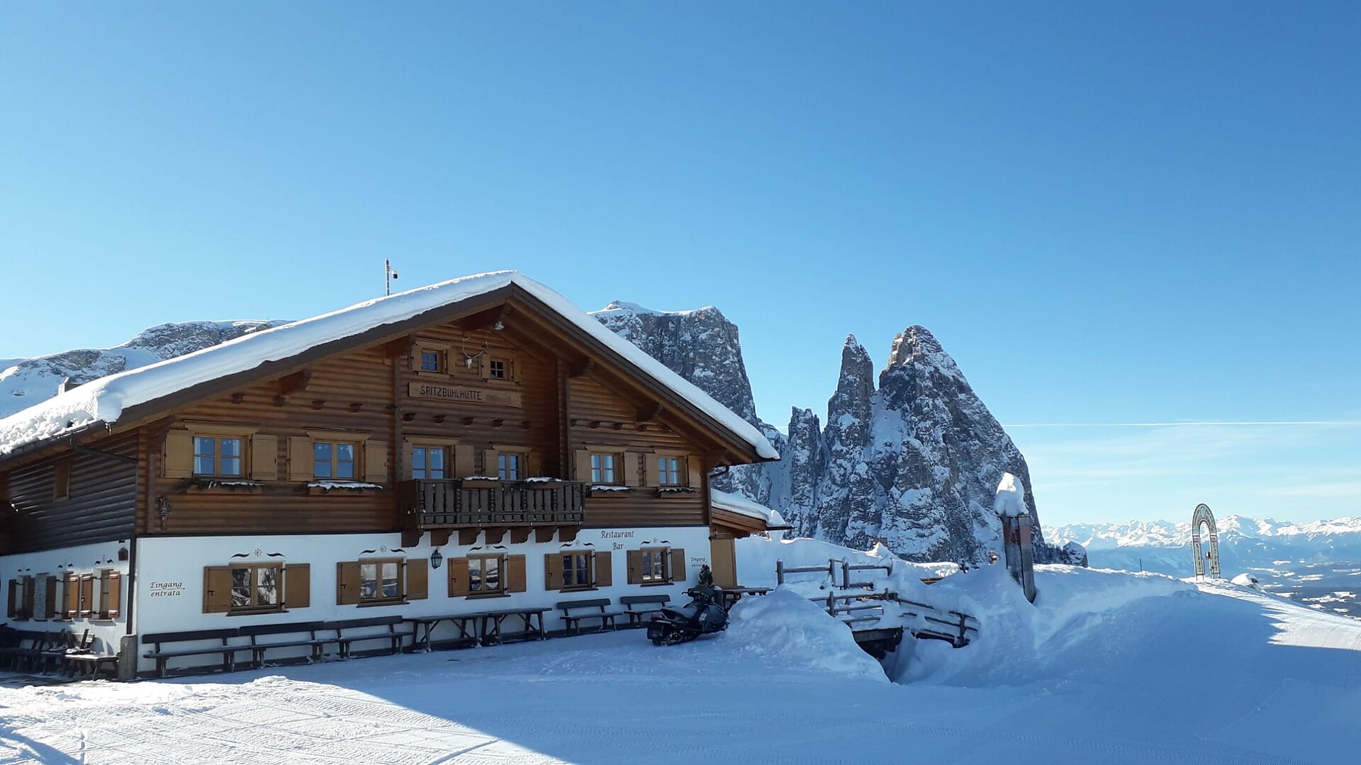
Südtirol Guide App Logo
Passer au contenu

ajouté(e) aux favoris

supprimé(e) des favoris

Oups ! Une erreur s’est produite. Réessayer

Ton compte est en cours de création

Ton compte a été créé avec succès et tu es maintenant connecté

Tu es connecté!

Ton compte a été créé avec succès, mais nous n'avons pas pu te connecter automatiquement

Tu es déconnecté

Filtrer
Filtres sélectionnés
    Niveau de difficulté
    Durée
    Distance en km
    Manger & boire

    Vivre la montagne dans les alpages du Sud-Tyrol

    Que serait la randonnée dans le Sud-Tyrol sans la traditionnelle "Brettl-Marende" ? Le Sud-Tyrol compte près de 200 alpages et refuges situés entre 300 mètres et 2.000 mètres d'altitude, surplombant les vallées et offrant une vue magnifique sur les montagnes. Que ce soit sur le haut plateau de l'Alpe de Siusi, sur le Hirzer, sur le Salten ou dans d'autres parties du pays : Là où se trouvent les sentiers de randonnée, les délicieuses possibilités de se restaurer ne sont généralement pas loin. Ainsi, ta prochaine randonnée dans les alpages sera un moment fort pour toute la famille.

    Résultats
    Alpine Farms
    Bacherhütte
    Mühlbach/Rio di Pusteria, Brixen/Bressanone and environs
    The Bacherhütte is an ideal finish after a calm hike with the family. Open from mid May to end of October and from the beginnings of Dicember to Easter. You can reach the Bacherhütte from the parking lot Gitschberg in about 1 hour and 15 minutes.
    Alpine Farms
    Flatschberg Alm
    Ulten/Ultimo, Meran/Merano and environs
    Ausgangspunkt: Parkplatz Flatschhöfe (1.750 m), Wanderweg: Nr. 143, Endpunkt: Flatschberg Alm, Gehzeit: 1 h 30 min, Höhenunterschied: 360 m (leichte Bergtour)
    Alpine Farms
    Moarerbergalm
    Ratschings/Racines, Sterzing/Vipiteno and environs
    Starting point: head valley Val Ridanna - Masseria (1.417m) Start at the gate and follow the asphalted road uphill, very steep at first, then a little flatter after 800m. At the bridge we turn left and follow the signposts to the mountain pasture Moarerbergalm. After the Poschhaus ruin we turn off to the right and hike approx. 200m to the mountain pasture Moarerbergalm. Alternative: reachable by using the bus of the Mining Museum, registration required (Tel. +390472656364) Tip: homemade cheese and butter
    Alpine Farms
    Valtiglalm
    Ratschings/Racines, Sterzing/Vipiteno and environs
    Starting point: upper Gasse (1.500m) The hiking tour starts in Gasse in Ridanna. You can also take the car and drive on for about 15 minutes. Turn left towards “Entholz” and at the sign to the Valtiglalm drive on about 2 kilometers until you reach a wooden bridge, where you can park your car. Then follow the path no. 26 upwards to the mountain pasture Valtiglalm. Tip: traditional dishes
    Alpine Farms
    St. Anna Pfistradalm Alp
    St.Leonhard in Passeier/San Leonardo in Passiria, Meran/Merano and environs
    St. Anna Pfistradalm Alp (1,350 m) Starting point: St. Leonhard/S. Leonardo, parking area Schnitzerhof farm ¦ Walten/Valtina, "Sagstatt" Hiking trail number: 13 ¦ 12+13a+13 Difference in altitude: 500 m ¦ 300 m Walking time: 1,5 hours ¦ 2 hours Difficulty level: medium Opening hours: end of May - beginning of October Closing day: none Accessible by baby carriage (from Schnitzerhof farm) - playground
    Alpine Farms
    Staudenbergalm
    Ratschings/Racines, Sterzing/Vipiteno and environs
    Starting point: Ridanna - Masseria (1.370m) Take the same route to the mountain pasture Martalm and then follow the marking no. 30 to the mountain pasture Staudenbergalm. Alternative: starting point Bergl (1.560m) to the Martalm and further on follow path no. 30. Tip: homemade bacon and sausages, on the weekend roasted kid or lamb
    Alpine Farms
    Schutzhaus Halbweghütte
    Kaltern an der Weinstraße/Caldaro sulla Strada del Vino, Alto Adige Wine Road
    Our family run restaurant is open since 1959. We offer our guests homemade meals typical from South Tyrol and Trentino. We have a comfy sitting room, a big terasse and a big children's playground. For group reservation we ask to make them in advance. New: E-Bike charging station.
    Alpine Farms
    Ausserwegeralm 1.956m
    Rasen-Antholz/Rasun Anterselva, Dolomites Region Kronplatz/Plan de Corones
    Starting Point: Lake Antholz | Staller Saddle Roundtrip: 3h (from Lake Antholz) | 40 min. (from Staller Saddle) Hiking Trail: 11,113
    Alpine Farms
    Grentealm Messnerwirt 2.002m
    Rasen-Antholz/Rasun Anterselva, Dolomites Region Kronplatz/Plan de Corones
    Starting Point: Antholz Mittertal, Antholz Mittertal, parking lot for the Grente Alm hut Roundtrip: approx 3h | 5h (depending on starting point) Hiking Trail No. 6
    Alpine Farms
    Hinterpasslerhütte 1.956m
    Rasen-Antholz/Rasun Anterselva, Dolomites Region Kronplatz/Plan de Corones
    Starting Point: Lake Antholz | Staller Saddle Roundtrip: 3h (from Lake Antholz) | 40 min. (from Staller Saddle) Hiking Trail: 11,113
    Alpine Farms
    Sot Pütia Hut
    San Martin /San Martino, Dolomites Region Kronplatz/Plan de Corones
    ONlin 20 minutes from the car park, perfect spot to sit back and marvel at the Sas de Pütia while discovering the traditional Ladin cuisine.
    Alpine Farms
    Wollbachalm hut
    Ahrntal/Valle Aurina, Ahrntal/Valle Aurina
    Accessible for old and young (even with baby strollers or by mountain bike). Located 30 minutes from the parking lot on foot, the hut is an ideal hiking destination also when the weather is inconsistent.

    Stop by and enjoy a 'Brettljause' (a plate of cold cuts) or other Ahrntal valley delicacies while you are surrounded by a breath-taking mountain backdrop.

    Alpine Farms
    Latscher Alm
    Latsch/Laces, Vinschgau/Val Venosta
    Family Tschenett awaits you with typical South Tyrolean delicacies on the Latscher Alm. Bikers, hikers and connoisseurs are always welcome.
    Alpine Farms
    Baronkaser
    Sterzing/Vipiteno, Sterzing/Vipiteno and environs
    The Baronkaser is one of the three chees dairy's of the Vallming village on the Monte Cavallo.
    Alpine Farms
    Obermair Alm
    Mühlwald/Selva dei Molini, Ahrntal/Valle Aurina
    The Obermair alpine pasture is located near Lake Wengsee above Selva dei Molini/Mühlwald. It is also accessible via the forest road.
    Alpine Farms
    Gampiel Alm
    Vintl/Vandoies, Brixen/Bressanone and environs
    The Gampiel Alpine pasture is a family business aside from overrun hiking trails. It is starting point of several walking tours. Exquisite panorama sight of the Dolomites. Tyrolean specialities, yoghurt of own produktion. Open in June only on Saturdays and Sundays; from 1. July to end of September open dayly. You can reach the Gampielalm in 2 hours from the parking Dun
    Alpine Farms
    Jaufen Alp
    St.Leonhard in Passeier/San Leonardo in Passiria, Meran/Merano and environs
    Jaufen Alp (1,850 m) The alp is located directly on the street below the Jaufenpass mountain pass. Starting point: Walten/Valtina, parking place in front of the inn Alpenrose Hiking trail number: 17a+17b+17 or 17 Difference in altitude: 600 m Walking time: 1,5 hours Difficulty level: medium Opening hours: June - October Closing day: Monday (holidays no closing day) Accessible by car - playground
    Alpine Farms
    Pfandler Alp
    St.Leonhard in Passeier/San Leonardo in Passiria, Meran/Merano and environs
    Pfandler Alp (1,350 m) Starting point: St. Martin/S. Martino, parking area above Pfandlerhof farm ¦ top terminal "Klammeben" of the Hirzer aerial tram Hiking trail number: E5 Difference in altitude: 205 m ¦ 650 m (descent) Walking time: 45 minutes ¦ 3 hours Difficulty level: easy ¦ medium Opening hours: 01/05 - 31/10 Closing day: Friday Accessible by baby carriage (from Pfandlerhof farm) - accommodation - playground - wildlife enclosure
    Alpine Farms
    Utia de Resciesa
    Urtijëi/Ortisei, Dolomites Region Val Gardena
    Enjoy high-quality, home-made delicacies from the traditional South Tyrolean cuisine, prepared with love and culinary art for our guests. Our plates are served in the cozy hut or on the sunny terrace with a view of the surrounding imposing mountains.
    Alpine Farms
    Ütia Munt de Fornella
    San Martin /San Martino, Dolomites Region Kronplatz/Plan de Corones
    Cosy hut at the foot of Sass de Pütia, easily reached from Passo delle Erbe in 20 minutes. Typical Ladin dishes, on Sundays BBQ and tutres
    Alpine Farms
    Angerer Alp
    Olang/Valdaora, Dolomites Region Kronplatz/Plan de Corones
    From the “Panorama” restaurant, trail no. 22 leads up to the Angerer Alm, which can be reached in about 45 minutes. The forest road covers around 400 metres of elevation gain, and at the top you can reward yourself with regional dishes and delicious desserts. The starting point is accessible by Citybus 435.1 – simply get off at the “Olang, Abzweigung Panorama” stop and follow the trail signs. By bike, the alpine hut is easily reached from the Children’s World via trail no. 22.
    Alpine Farms
    Simile Mahd Alm
    Mühlbach/Rio di Pusteria, Brixen/Bressanone and environs
    An alp with traditional kitchen, a sunny and calm position and a perfect stop for biker and walker. Open from mid June to mid September.
    Alpine Farms
    Unterrieseralm
    Sand in Taufers/Campo Tures, Ahrntal/Valle Aurina
    In the Rieserferner-Ahrn Nature Park. Traditional local dishes, homemade butter and "Graukäse"
    Alpine Farms
    Kuttnhütte
    Mühlbach/Rio di Pusteria, Brixen/Bressanone and environs
    The hut “Kuttn” is situated on the alp of Fane (1,700 m) at the end of the Valley Valles/Vals. The sun-terrace is the right backdrop for a hiking break with hut specialties and the homemade cheese, which is produced directly at the cheese dairy next to the hut. Open from middle of April to middle of November. You can reach the Kuttnhütte from the parking lot at Fane Alm in about 10 minutes. Otherwise, it takes about 1.5 hours from the parking lot at the Kurzkofelhütte to the Kuttnhütte.
    Alpine Farms
    Obere Gostalm Alp
    Moos in Passeier/Moso in Passiria, Meran/Merano and environs
    Obere Gostalm Alp (1,990 m) Starting point: Timmelsjoch High Alpine Road, parking area Platterköfel Hiking trail number: 29b Difference in altitude: 350 m Walking time: 45 minutes Difficulty level: easy Opening hours: beginning of June - middle of October Closing day: none Accessible by baby carriage - playground
    Alpine Farms
    Bockhütte Alp
    Moos in Passeier/Moso in Passiria, Meran/Merano and environs
    Bockhütte Alp (1,899 m) Starting point: Stuls/Stulles, parking area Hochegg ¦ Jaufenpass mountain pass, "Römerkehre" ¦ curve Rabenstein/Corvara Hiking trail number: 14+14b+15b ¦ 12a+12+15+15a+15b ¦ 26+14b+15b Difference in altitude: 260 m ¦ 400 m (ascent) 490 m (descent) ¦ 430 m Walking time: 40 minutes ¦ 5 hours ¦ 1 hour 45 minutes Difficulty level: medium Opening hours: beginning of May - beginning of November Closing day: none Accessible by baby carriage (from Stuls/Stulles) - playground
    Alpine Farms
    Prantacher Alm - Fartleis Alp
    St.Martin in Passeier/San Martino in Passiria, Meran/Merano and environs
    Prantacher Alm - Fartleis Alp (1,470 m) Starting point: car park "Fartleishöfe" ¦ St. Martin/S. Martino ¦ St. Leonhard/S. Leonardo Hiking trail number: 2 ¦ 2 ¦ E5 + 2a + 2 Difference in altitude: 350 m ¦ 870 m ¦ 820 m Walking time: 1 hour ¦ 2 hours 45 minutes ¦ 3 hours Difficulty level: easy¦ medium ¦ medium Opening hours: May - October Closing day: none Our alp is easily accessible and ideal for a family hike or bike tour. We offer Alpine dishes prepared with lots of love, a sun terrace to enjoy, a small playground and lots for the little ones to discover!
    Alpine Farms
    Obisell Alm Alp
    Riffian/Rifiano, Meran/Merano and environs
    Obisell Alm Alp (2,160 m) Starting point: "Öbersthöfe" Vernuer/Vernurio Hiking trail number: 5 or 21a+21 Difference in altitude: 760 m Walking time: 2 hours or 2,5 hours Difficulty level: medium Opening hours: middle of June - middle of October Closing day: none
    1 2 3 4 5 6 7 8 9 10 11 12 13 14 15 16 17