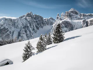
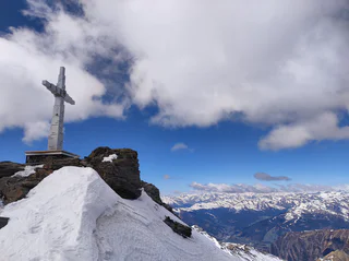
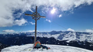
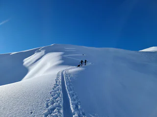
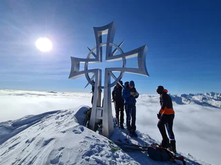
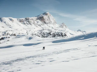
Passer au contenu
ajouté(e) aux favoris
supprimé(e) des favoris
Oups ! Une erreur s’est produite. Réessayer
Ton compte est en cours de création
Ton compte a été créé avec succès et tu es maintenant connecté
Tu es déconnecté
Filtrer
Filtres sélectionnés
    Niveau de difficulté
    Durée
    Distance en km
    Activités

    Randonnées à ski dans le Sud-Tyrol

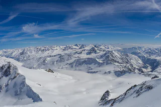
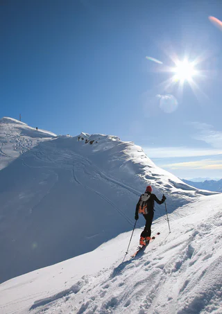
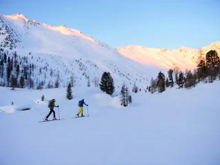
    Un paysage intact, une quiétude absolue en dehors des pistes et des pentes bien enneigées avec de la poudreuse et des névés. Vous voulez partir à l'assaut des Dolomites ? Ou bien préférez-vous des sommets aux pentes plus douces ? Raffolez-vous des vues panoramiques ? Ou seuls les plus hauts sommets sont-ils capables de vous satisfaire ? Quel que soit le type de randonnée à ski que vous choisissez, le Sud-Tyrol vous donne la garantie de profiter d'aventures sportives et d'expériences uniques dans la nature.

    Résultats
    Ski Tours
    Ski tour Großer Tauernkopf/Testa dei Tauri 2,874 m
    Prettau/Predoi, Ahrntal/Valle Aurina

    Wonderful Ski Tour in Kasern/Casere on the sunny side the Zillertal Alps. 


    Slope orientation: south-east, west

    Highest point: 2,874 m 

    Altitude difference: 1,274 m

    Approx. time for ascent: 5 hours


    Avalanche danger: moderate

    > Avalanche report


    Information without guarantee

    Difficulté : moyenne
    1290 altitude
    5h:00 min durée
    Ski Tours
    Skitouring Mittereck in Vallelunga/Langtaufers
    Graun im Vinschgau/Curon Venosta, Vinschgau/Val Venosta

    Mittereck Mountain in Vallelunga is truly magnificent skiing. The route is quite clear and there is a very low avalanche risk—as long as you make sensible choices. Just one safety note: good equipment, an appropriate level of physical fitness, comprehensive planning of the ski tour, and the ability to recognise natural hazards are essential. Slope orientation: North Starting point: Caprone/Kapron, Gehöft Perwag

    Difficulté : moyenne
    0 altitude
    4h:00 min durée
    Ski Tours
    Skitouring Furnacia - La Crusc
    Badia, Dolomites Region Alta Badia

    An easy ski mountaineering excursion on a groomed path which, after an initial stretch of woodland, soon gives you a way to a magnificent landscape, with the Putia mountain and the Gardenacia plateau being the first ones to be seen during the ascent. A little higher up, the white enchantment of the Armentara meadows awaits you, one of the wonders of Alta Badia, with the imposing Sasso Croce peeping out. On the final ascent, the spectacular landscape also includes the majestic Sassongher and the Sella Group.

    Difficulté : facile
    356 altitude
    1h:30 min durée
    Mountaineering
    to the Grionplotten - Ski tour an higking
    Graun im Vinschgau/Curon Venosta, Vinschgau/Val Venosta

    Worthwhile hike.
    The Tour has in good conditions and reasonable route choice on any particular difficulties. When visibility is poor is absolutely to be avoided.

    Difficulté : moyenne
    0 altitude
    3h:00 min durée
    Ski Tours
    Ski Tour Schaufler 2,265 m
    Ahrntal/Valle Aurina, Ahrntal/Valle Aurina

    An easy excursion in the beautiful mountains of the Ahrntal valley!


    Slope orientation: South-East

    Highest point: 2,265 m

    Altitude difference: 905 m

    Approx. time for ascent: 3 hours


    Avalanche danger: low


    > Avalanche report


    Information without guarantee

    Difficulté : facile
    827 altitude
    3h:00 min durée
    Ski Tours
    Skitouring trail Brunst hut
    Al Plan/San Vigilio, Dolomites Region Kronplatz/Plan de Corones

    A real insider tip is the ski touring trail to the Brunst hut, which is prepared weekly with the snow cat.
    In the midst of the UNESCO Dolomites World Heritage, the path winds its way up to the alpine hut, where you can warm up in a room and enjoy the breathtaking view to the Dolomites of Olang.
    Attention: The path is closed in the evening due to the preparation.

    Difficulté : moyenne
    758 altitude
    2h:31 min durée
    Ski Tours
    Ski moutaineering to Hohe Wiegenspitze (from Certosa/Karthaus)
    Schnals/Senales, Meran/Merano and environs

    Starting point: Certosa/Karthaus (1,327 m a.s.l)
    Ascent: 1,653 m elevation gain, 4.5 hours
    Best time: April and May

    Together with the Kleinen Wiegenspitze that is situated slightly northwards, the Hohe Wiegenspitze rises between the Mastauntal and the Penaudtal valleys. Follow the trail from Certosa/Karthaus into the Penaudtal valley, as in ski tours to the Grubenspitze, the Vermoi Peak and and the Mountain Zerminiger. At mountain pasture Penaud (2,319 m a.s.l), take a right and follow the rather steep but sunny southern slope upwards to the summit. You can descend either by the same route or through the Mastauntal valley (ski tour to the Hohe Wiegenspitze from Madonna di Senales/Unser Frau).

    For practised skiers.


    Difficulté : difficile
    1677 altitude
    6h:45 min durée
    Ski Tours
    Skitour to GLockhauser
    Graun im Vinschgau/Curon Venosta, Vinschgau/Val Venosta

    Starting point of the ski tour to the Glockhauser mountain is the car park in Melago/Melag. From there north-westward across soft ground up to the last post of a disused ski lift. Across the steep slope towards the right and further towards Melagtal Valley. At the bridge, cross to the right-hand side of the valley and at a height of 2,300 m veer left to the Schönkar ridge. After the large trough from right to left across stepped terrain on to a shoulder. Across the back, left up to the ridge (take care!) and further up to the summit. Your climb is rewarded with a beautiful valley view and panoramic view to the nearby summits.

    Descend via the Mitterkar or along the ascent route.

    Difficulté : moyenne
    1013 altitude
    3h:07 min durée
    Ski Tours
    To the Piz Pleres in winter
    Vinschgau/Val Venosta

    This ski tour in the Matscher Valley is especially suitable as a firn tour in spring. It is very popular and, with its well-graded slopes, is one of the easier tours. On the Pleresspitze you can enjoy a magnificent view. The mountain panorama to the north-east with the Weißkugel is particularly special.  

    Difficulté : moyenne
    1370 altitude
    4h:30 min durée
    Ski Tours
    Skitour to Grionkopf
    Graun im Vinschgau/Curon Venosta, Vinschgau/Val Venosta

    From the car park on the right side of the valley, the route initially heads south into the valley. In a right turn slightly uphill into the Grion valley. At the bottleneck and also afterwards always stay to the right (caution!) of the stream or valley. Continue south over slopes and hollows. Below the Schartl, caution! In western (right) direction further into a saddle. From there turn left towards the ridge and continue to the summit.

    Difficulté : moyenne
    0 altitude
    3h:00 min durée
    Ski Tours
    Ski moutaineering to Finail Peak
    Schnals/Senales, Meran/Merano and environs

    Starting point: Maso Corto/Kurzras (2,011 m a.s.l)
    Ascent: 646 m elevation gain, 3 hours, from the Giogo Alto/Hochjoch glacier (Refuge Bella Vista 2,842 m a.s.l)
    Best time for departure A: December to May
    Best time for departures B and C: March to May

    This is a very pleasant tour on a mountain that is still very much glaciated on the north side but that is not without its risks in one part where the “icefall” east of the Giogo Alto/Hochjoch glacier is hazardous due to glacier crevasses. The ascent is from Maso Corto/Kurzras to the Bella Vista lodge or with the Schnalstal valley cable car to the Giogo Alto/Hochjoch glacier; you leave the east side by climbing through the icefall. Avoiding the crevasses, the trail rises steeply to the upper glacier terrace, and keeping to the west of the summit, very steeply to the ridge shoulder. Continue along the short but exposed ridge to the summit.

    Descent A: go along the ascent route to the Giogo Alto/Hochjoch pass and descend to the valley as far as Maso Corto/Kurzras or take the Schnalstal Valley cable car.

    Descent B: Taking the first steep slope down, then to the right/north-east and continue south-easterly and southwards to the Giogo Alto/Niederjoch pass and on to the Refuge Similaun.

    Descent C: Northwards towards the Hochjoch-Hospiz hut and Vent (A)

    For good skiers with Alpine experience

    Difficulté : moyenne
    634 altitude
    3h:16 min durée
    Ski Tours
    Skitour Valbenair peak
    Graun im Vinschgau/Curon Venosta, Vinschgau/Val Venosta

    From the parking lot in Melago/Melag in Langtaufers valley you go to the Melager Alm Alpine Pasture. After 100 m you turn right and follow trail no. 5 in direction to "Planeilscharte" through the wood. Then you follow the east ridge until you reach the Valbenairspitz peak.

    Difficulté : difficile
    1301 altitude
    5h:01 min durée
    Ski Tours
    Skitour Großer Schafkopf
    Graun im Vinschgau/Curon Venosta, Vinschgau/Val Venosta

    From Gasthof Alpenfriede across meadows to the left onto a forest path. On this up to the level of a mountain barn, turn left there and follow the old military road until you cross the forest line. Caution is advised there. After that the terrain becomes pleasant and flat. Over wide hollows to the right of the saddle, Wetterkreuz, past and up to Wölfelesjoch. There the prominent south ridge begins, which is partly done on skis and on foot.

    Difficulté : moyenne
    1141 altitude
    4h:25 min durée
    Ski Tours
    Ski tour Merbjoch/Passo Merbe 2,829 m
    Prettau/Predoi, Ahrntal/Valle Aurina

    Panoramic ski-tour to the Merbjoch/Passo Merbe above Prettau/Predoi .


    Slope orientation: north

    Highest point: 2,829 m

    Altitude difference: 1,359 m

    Approx. time for ascent: 4,5 hours


    Avalanche danger: frequent

    > Avalanche report


    Information without guarantee

    Difficulté : moyenne
    1370 altitude
    3h:58 min durée
    Ski Tours
    Ski moutaineering to Gerstgraser Peak
    Schnals/Senales, Meran/Merano and environs

    Starting point: Madonna di Senales/Unser Frau (1,508 m a.s.l)
    Ascent: 1,586 m elevation gain, 5 hours
    Best time: March to May

    A double summit (western summit 3,083 m a.s.l, eastern summit 3,094 m a.s.l) to the west of the Mastaun summit and the Mastaunjoch pass. Take the trail upwards from Madonna di Senales/Unser Frau through the Mastauntal Valley, as with Tours 9, until you reach flat ground having negotiated the steep slope. Then, take a right in a north-westerly direction until you come to the Mastaunjoch pass (2,927 m a.s.l) and the quite difficult climb up to the western summit. You can also turn off towards the north beneath the Mastaunjoch pass and climb to the eastern summit, which is the easier one. The descent is similar to the ascent.

    For practised skiers with Alpine experience

    Difficulté : moyenne
    1507 altitude
    5h:25 min durée
    Ski Tours
    Ski moutaineering to Similaun
    Schnals/Senales, Meran/Merano and environs

    Starting point: Mountain station Grawand (3,212 m a.s.l) or Refuge Bella Vista (2,842 m a.s.l)
    Best time: March to May
    Degree of difficulty: for good skiers with Alpine experience

    Day 1 ascent: 600 m elevation gain, 4 hours
    The same ascent route as ski tour to the Ötzi discovery site; the trail then takes you downhill on the Niederhochferner glacier and briefly uphill to the Refuge Similaun (3,019 ma.s.l).

    Day 2 ascent: 600 m elevation gain, 2 hours
    The ascent goes from the Similaun lodge to Similaun in a south-easterly direction over the Niederjochferner glacier, rising only slightly to begin with but becoming steeper, up to a narrow and often monitored summit ridge.

    Descent A: descend back along the ascent route.

    Descent B: eastwards to the Similaunjoch pass and then northwards over the Marzellferner glacier to the Mountain hut Martin-Busch and on to Vent (A)

    Descent C: eastwards to the Similaunjoch pass and then southwards over the Grafferner glacier and Graftal Valley to Inn Jägerrast  (Vorderkaser) in the Pfossental Valley.

    Of the 3 options, descent C (down into the Pfossental Valley) is highly recommended but only in good conditions.

    Difficulté : difficile
    1422 altitude
    6h:54 min durée
    Ski Tours
    Ski moutaineering to Palla Bianca/Weißkugel
    Schnals/Senales, Meran/Merano and environs

    Route A

    Starting point: Maso Corto/Kurzras, car park (2,011 m a.s.l)
    Ascent: 1,728 m elevation gain, 6-7 hours
    Best time: March to May

    This tour is difficult alone due to the difference in elevation. From Maso Corto/Kurzras along the Sommerweg (summer path as far as the bridge; then in each case take a right into the Steinschlagtal Valley. Climb up through the valley, which is narrow at the start but then widens out. Head towards the north-west, cross the Steinschlagferner glacier and cross over through Quellenjoch pass to the Matscherferner glacier; or at 2,900 m a.s.l, veer right over steep slopes to the ridge where you reach the traces of the Hintereisfern glacier. Moving further north, you arrive at the Hintereisjoch pass where you can climb the Weißkugel by the south ridge. You can only reach the secondary summit with skis. The climb to the 30 m high main summit is very exposed. You can descend either by the same route or by the Bella Vista route (Route B).

    Only for good and very fit touring skiers with Alpine experience.

    Route B

    Starting point: Maso Corto/Kurzras, mountain station Grawand (3,212 m a.s.l) or Refuge Bella Vista (2,842 m a.s.l – with overnight stay)
    Ascent: 1,150 m elevation gain, 5 hours
    Best time: March to the beginning of May

    The tour starts at the Hintereis chair lift mountain station. The trail continues diagonally westwards, beneath the Im Hinter Eis mountain (3,270 m a.s.l) to the ridge shoulder at 3,163 m a.s.l. Downhill to the Hintereisferner glacier as far as the trail that comes up from Vent. Arrive at Hintereisjoch pass having passed over the flat Hintereisferner glacier, from there northwards and over the south ridge to the secondary summit of the Weißkugel. You can descend by the same route or by the route described in Route A or C.

    For good skiers with Alpine experience

    Route C

    Starting point: Maso Corto/Kurzras, mountain station chairlift Teufelsegg (3,034 m a.s.l)
    Ascent: 1,000 m elevation gain, 4 hours
    Best time: March to the beginning of May

    with the construction of the chairlift Teurelsegg, the tour to the Weisskugel peak is mainly started from there. The disadvangage, however, is that many tourers usually start at the same time. The ascent is via Teurelsegg (3,227 m a.s.l) from there short descent to the Hintereisferner. Via the flat Hintereisferner you reach the Hintereisjoch (3,471 m a.s.l). From there turning north, overcoming the steep mud wall and over the south degree to te pre-peak of the Weißkugel (there is a skidepot). To the 30 m main summit one reaches an exposed degree. The descent is the same as the ascent route and then back down to the valley via the slopes, both routes variant A an B for good skiers with alpine experience.

    Difficulté : moyenne
    1099 altitude
    3h:46 min durée
    Ski Tours
    Ski Tour Speikboden 2,517 m
    Ahrntal/Valle Aurina, Ahrntal/Valle Aurina

    Easy tour with a stunning panoramic view.


    Highest point: 2,517 m

    Altitude difference: 1,150 m

    Approx. time for ascent: 5 hours


    > Avalanche report


    Information without guarantee

    Difficulté : facile
    1176 altitude
    4h:00 min durée
    Ski Tours
    Ski moutaineering to pre-summit Trumserspitze
    Schnals/Senales, Meran/Merano and environs

    Starting point: Certosa/Karthaus (1,327 m a.s.l.)
    Ascent: 1,474 m elevation gain, 4 hours
    Best time: winter and early spring

    Uphill and downhill possible with skis from  to Certosa/Karthaus if the snow conditions are good. Referred to as Gamseck on some maps. The ascent is from Certosa/Karthaus along the road to Farmstead Sennhof and then on the forest path to malga del convento, above Certosa/Karthaus, from there continue southwards to the highest and rather steep ascent to the secondary summit of the Trumserspitze.

    Descent A: The same as the ascent route and the road to Certosa/Karthaus.

    Descent B: Northwards to malga del convento and along the forest path as far as the viewing point for Certosa/Karthaus and then directly downhill to Certosa/Karthaus through the forest aisle.

    For practised skiers

    Difficulté : moyenne
    1600 altitude
    5h:52 min durée
    Ski Tours
    Skitour Innerer Nockenkopf
    Graun im Vinschgau/Curon Venosta, Vinschgau/Val Venosta

    From Rojen across the animal gathering path up to the last larch stand, valley inwards on a slightly ascending path to the Mitter-Scharte and finally over a steep ridge to the summit.

    Difficulté : difficile
    796 altitude
    2h:52 min durée
    Snowshoe Hikes
    To the Watleskreuz in winter
    Vinschgau/Val Venosta

    The tour to the Watleskreuz leads along a comfortable path through the wintry landscape. Here, above all, the beautiful mountain scenery becomes a highlight for the winter hiker.   

    Difficulté : moyenne
    406 altitude
    1h:18 min durée
    Ski Tours
    Ski moutaineering to Langgrubjoch
    Schnals/Senales, Meran/Merano and environs

    The ski tour to Langgrubjoch is still relatively popular. It is relatively easy and not as challenging as the tours on the high neighbouring peaks. However, it does rise to over 3,000 m and offers a good insight into the mountain world of Schnalstal Valley.

    Difficulté : moyenne
    1163 altitude
    3h:42 min durée
    Ski Tours
    Ski Touring Laite Va Piz
    Villnöss/Funes, Dolomites Region Villnösstal

    Start at Ranui, car park Waldschenke (1,370 m), in direction Weissbrunn and Brogles Alm and on the Laite Va Piz (2,284 m)

    Difficulté : moyenne
    921 altitude
    3h:01 min durée
    Ski Tours
    Ski moutaineering to Mountain Stotz
    Schnals/Senales, Meran/Merano and environs

    Starting point: Maso Corto/Kurzras, Masi Kofel/Koflhöfe (1,938 m a.s.l.)
    Ascent: 949 m elevation gain, 3 hours
    Best time: December to April

    A pleasant tour and not too difficult; only the part through the woods, along the narrow Sommerweg is somewhat difficult, especially when descending. The ascent starts at Koflhof farm (0.7 km before Maso Corto/Kurzras), moving southwards through the Lagauntal Valley. Before the valley basin, go to the right up the slope north-westwards, arriving at Stotz, north of the Saldurkamm mountains. You can descend either by the same route or by going north via Lazaun Mountain hut to Maso Corto/Kurzras.

    Also suitable for intermediate-level skiers.


    Difficulté : facile
    968 altitude
    3h:34 min durée
    Ski Tours
    Skitour Weissseejoch
    Graun im Vinschgau/Curon Venosta, Vinschgau/Val Venosta

    From Melag (car park) in northern direction diagonally left to the upper end of the drag lift. From there diagonally right over the southern slope up to a level with a crossroads (2090 m). Flat right to the bridge over the Melager stream. On the right side of the valley inwards to point 2321 m on the map. Here the brooks divide ("Zwischenbach" on the map). One climbs up a little steeply to the left of the right stream and ends on a hill at the beginning of a wide, flat valley. Through this valley to its end. There through a short but steep hollow up to a saddle (2600 m). Through the following, flat hollow at the left edge until
    to their end. Up through a hollow again. Then first right over a ridge and further left into a flat depression (2800 m). Through it, then again left through a hollow and right up to the yoke with the wayside cross. Up to the elevation at 3049 m, one climbs another half hour with the skis on the left and then over a short ridge - not difficult - to the worthwhile lookout point with a pole.

    Difficulté : moyenne
    1036 altitude
    3h:58 min durée
    Ski Tours
    Ski moutaineering to Texelspitze
    Schnals/Senales, Meran/Merano and environs

    Starting point: Pfossental Valley, car park Gasthof Jägerrast inn (1,693 m a.s.l)
    Ascent: 1,625 m elevation gain, 5-6 hours
    Best time: March to mid-June

    The Texelspitze is not only well known for its Nature Park but is also very popular because of the wonderful ski touring run. However, the tour is somewhat difficult due to the long climb through the Pfossental valley. After travelling along the forest path on the bottom of the valley for about 5 km you’ll arrive at Maso Gelato/Eishof farm at 2,069 m a.s.l. Take a right here over the stream and southwards, firstly on a sleep slope and then across splendid ridges to arrive at the Texelferner glacier. Cross the glacier, the trail rising in a southerly direction as far as the south-west side of the summit. The final steps to the summit can be taken once you’ve removed your skis. The best descent is by the same route.

    For good skiers with Alpine experience

    Difficulté : difficile
    1674 altitude
    6h:13 min durée
    1 2 3 4 5 6