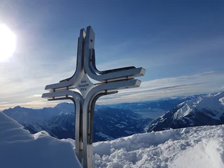
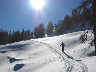
1/5
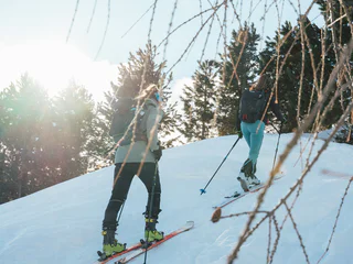
Ski tour from Flading to the Kleine Kreuzspitze summit (2518 m)
Stulles/Stuls, Ratschings/Racines, Sterzing/Vipiteno and environs
medium
Poziom trudności
1033 m
Wzlot
3h:10 min
czas trwania
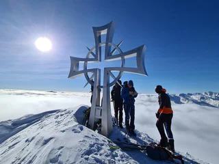
Dziewiczy krajobraz, spokój i cisza z dala od tras zjazdowych, zbocza pokryte głębokim puchem i firnem. Porywasz się na Dolomity? Wolisz łagodniejsze podejścia? Uwielbiasz dalekie panoramy? A może satysfakcjonują cię wyłącznie najwyższe osiągnięcia? Każdy wybór będzie dobry, bo skitury w Południowym Tyrolu oznaczają zawsze niesamowite wrażenia w zetknięciu z przyrodą oraz sportową przygodę.
1/5
Stulles/Stuls, Ratschings/Racines, Sterzing/Vipiteno and environs
medium
Poziom trudności
1033 m
Wzlot
3h:10 min
czas trwania
1/3
Fundres/Pfunders, Vintl/Vandoies, Brixen/Bressanone and environs
difficult
Poziom trudności
1000 m
Wzlot
2h:45 min
czas trwania

Stulles/Stuls, Moos in Passeier/Moso in Passiria, Meran/Merano and environs
medium
Poziom trudności
1073 m
Wzlot
3h:00 min
czas trwania
1/8
S. Giacomo/St. Jakob - Val di Vizze/Pfitsch, Pfitsch/Val di Vizze, Sterzing/Vipiteno and environs
difficult
Poziom trudności
1572 m
Wzlot
4h:47 min
czas trwania
1/5
Corvara/Corvara, Badia, Dolomites Region Alta Badia
medium
Poziom trudności
547 m
Wzlot
2h:16 min
czas trwania
Tesido/Taisten, Welsberg-Taisten/Monguelfo-Tesido
easy
Poziom trudności
700 m
Wzlot
3h:30 min
czas trwania
Sesto/Sexten, Sexten/Sesto, Dolomites Region 3 Zinnen
difficult
Poziom trudności
1337 m
Wzlot
4h:40 min
czas trwania
1/5
San Vigilio, Olang/Valdaora, Dolomites Region Kronplatz/Plan de Corones
medium
Poziom trudności
758 m
Wzlot
2h:31 min
czas trwania
S.Valentino /St. Valentin, Graun im Vinschgau/Curon Venosta, Vinschgau/Val Venosta
difficult
Poziom trudności
1301 m
Wzlot
5h:01 min
czas trwania
1/4
San Leonardo i.P./St. Leonhard i.P., Ratschings/Racines, Sterzing/Vipiteno and environs
medium
Poziom trudności
876 m
Wzlot
2h:40 min
czas trwania
1/6
S. Giacomo/St. Jakob - Val di Vizze/Pfitsch, Pfitsch/Val di Vizze, Sterzing/Vipiteno and environs
medium
Poziom trudności
1787 m
Wzlot
5h:34 min
czas trwania
Altavalle/Hintermartell, Martell/Martello, Vinschgau/Val Venosta
difficult
Poziom trudności
1251 m
Wzlot
4h:15 min
czas trwania
Glorenza/Glurns, Prad am Stilfser Joch/Prato allo Stelvio, Vinschgau/Val Venosta
medium
Poziom trudności
1354 m
Wzlot
3h:00 min
czas trwania
1/2
Valgiovo/Jaufental, Ratschings/Racines, Sterzing/Vipiteno and environs
medium
Poziom trudności
843 m
Wzlot
2h:32 min
czas trwania
Sesto/Sexten, Sexten/Sesto, Dolomites Region 3 Zinnen
medium
Poziom trudności
641 m
Wzlot
2h:51 min
czas trwania
1/2
Valles/Vals, Mühlbach/Rio di Pusteria, Brixen/Bressanone and environs
medium
Poziom trudności
560 m
Wzlot
2h:00 min
czas trwania
1/3
Casateia/Gasteig, Freienfeld/Campo di Trens, Sterzing/Vipiteno and environs
medium
Poziom trudności
1373 m
Wzlot
4h:10 min
czas trwania
Braies di Fuori/Ausserprags, Prags/Braies, Dolomites Region 3 Zinnen
medium
Poziom trudności
856 m
Wzlot
3h:07 min
czas trwania
1/4
S. Giacomo/St. Jakob - Val di Vizze/Pfitsch, Pfitsch/Val di Vizze, Sterzing/Vipiteno and environs
medium
Poziom trudności
1266 m
Wzlot
3h:58 min
czas trwania
1/3
Maso Corto/Kurzras, Schnals/Senales, Vinschgau/Val Venosta
medium
Poziom trudności
1163 m
Wzlot
3h:42 min
czas trwania
S.Martino/Reinswald, Sarntal/Sarentino, Bolzano/Bozen and environs
medium
Poziom trudności
890 m
Wzlot
2h:46 min
czas trwania
1/3
Maso Corto/Kurzras, Schnals/Senales, Vinschgau/Val Venosta
easy
Poziom trudności
968 m
Wzlot
3h:34 min
czas trwania
Fleres/Pflersch, Brenner/Brennero, Sterzing/Vipiteno and environs
medium
Poziom trudności
1267 m
Wzlot
4h:55 min
czas trwania
1/4
Valgiovo/Jaufental, Ratschings/Racines, Sterzing/Vipiteno and environs
difficult
Poziom trudności
1294 m
Wzlot
3h:57 min
czas trwania
1/9
Terento/Terenten, Terenten/Terento, Brixen/Bressanone and environs
medium
Poziom trudności
818 m
Wzlot
2h:40 min
czas trwania
1/3
Certosa/Karthaus, Schnals/Senales, Vinschgau/Val Venosta
medium
Poziom trudności
1600 m
Wzlot
5h:52 min
czas trwania
San Vigilio, Al Plan/San Vigilio, Dolomites Region Kronplatz/Plan de Corones
medium
Poziom trudności
682 m
Wzlot
2h:28 min
czas trwania
Pescosta/Pescosta, Sëlva/Selva di Val Gardena, Dolomites Region Val Gardena
easy
Poziom trudności
182 m
Wzlot
0h:58 min
czas trwania
Plan/Pfelders, Moos in Passeier/Moso in Passiria, Meran/Merano and environs
difficult
Poziom trudności
1844 m
Wzlot
6h:00 min
czas trwania
Anterselva di Sopra/Antholz-Obertal, Rasen-Antholz/Rasun Anterselva, Dolomites Region Kronplatz/Plan de Corones
medium
Poziom trudności
1280 m
Wzlot
4h:28 min
czas trwania
Dziękujemy za zapisanie się!
Rejestracja już aktywna
Potwierdź rejestrację
Aby zakończyć rejestrację, otwórz e-mail, który właśnie wysłaliśmy, i kliknij link potwierdzający.
Nie widzisz wiadomości? Sprawdź folder spam.
Otrzymujesz już nasze wyjątkowe oferty, przydatne wskazówki i specjalne propozycje, aby w pełni cieszyć się wakacjami.
Już próbowałeś zapisać się do naszego newslettera, ale nie potwierdziłeś rejestracji. Właśnie wysłaliśmy ci ponownie e‑mail. Sprawdź swoją skrzynkę odbiorczą i folder ze spamem i potwierdź teraz.


