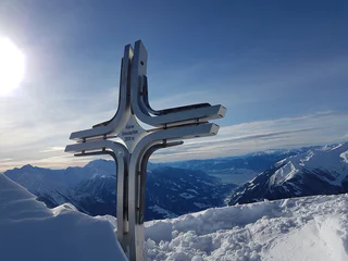
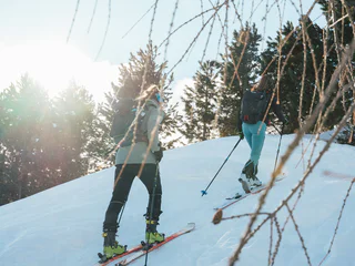
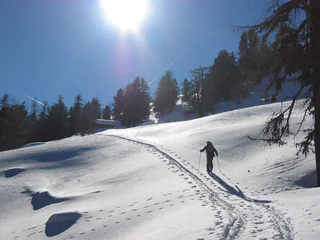
The tour to the Watleskreuz leads along a comfortable path through the wintry landscape. Here, above all, the beautiful mountain scenery becomes a highlight for the winter hiker.
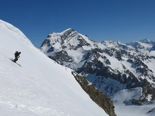
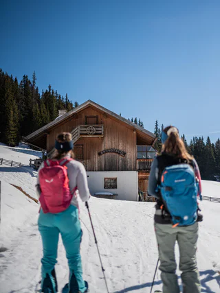
A pristine landscape, tranquility nearby the ski slopes and steep descents with powder and firn. Would you like to storm the Dolomites? Or would you prefer gentler peaks? Do you love endless horizons? Or are you only fulfilled with extremely high-altitudes? Whatever you decide to do: On a ski tour in South Tyrol you will enjoy unique nature experiences while doing sport adventures.
The tour to the Watleskreuz leads along a comfortable path through the wintry landscape. Here, above all, the beautiful mountain scenery becomes a highlight for the winter hiker.
This ski tour in the Matscher Valley is especially suitable as a firn tour in spring. It is very popular and, with its well-graded slopes, is one of the easier tours. On the Pleresspitze you can enjoy a magnificent view. The mountain panorama to the north-east with the Weißkugel is particularly special.
Worthwhile hike.
The Tour has in good conditions and reasonable route choice on any particular difficulties. When visibility is poor is absolutely to be avoided.
A real insider tip is the ski touring trail to the Brunst hut, which is prepared weekly with the snow cat.
In the midst of the UNESCO Dolomites World Heritage, the path winds its way up to the alpine hut, where you can warm up in a room and enjoy the breathtaking view to the Dolomites of Olang.
Attention: The path is closed in the evening due to the preparation.
An easy ski mountaineering excursion on a groomed path which, after an initial stretch of woodland, soon gives you a way to a magnificent landscape, with the Putia mountain and the Gardenacia plateau being the first ones to be seen during the ascent. A little higher up, the white enchantment of the Armentara meadows awaits you, one of the wonders of Alta Badia, with the imposing Sasso Croce peeping out. On the final ascent, the spectacular landscape also includes the majestic Sassongher and the Sella Group.
Starting point: Maso Corto/Kurzras (2,011 m a.s.l)
Ascent: 646 m elevation gain, 3 hours, from the Giogo Alto/Hochjoch glacier (Refuge Bella Vista 2,842 m a.s.l)
Best time for departure A: December to May
Best time for departures B and C: March to May
This is a very pleasant tour on a mountain that is still very much glaciated on the north side but that is not without its risks in one part where the “icefall” east of the Giogo Alto/Hochjoch glacier is hazardous due to glacier crevasses. The ascent is from Maso Corto/Kurzras to the Bella Vista lodge or with the Schnalstal valley cable car to the Giogo Alto/Hochjoch glacier; you leave the east side by climbing through the icefall. Avoiding the crevasses, the trail rises steeply to the upper glacier terrace, and keeping to the west of the summit, very steeply to the ridge shoulder. Continue along the short but exposed ridge to the summit.
Descent A: go along the ascent route to the Giogo Alto/Hochjoch pass and descend to the valley as far as Maso Corto/Kurzras or take the Schnalstal Valley cable car.
Descent B: Taking the first steep slope down, then to the right/north-east and continue south-easterly and southwards to the Giogo Alto/Niederjoch pass and on to the Refuge Similaun.
Descent C: Northwards towards the Hochjoch-Hospiz hut and Vent (A)
For good skiers with Alpine experience
This easy ski tour that leads up to the Golfen/Monte Calvo is a pleasure tour. The tour can be done also soon even after snowfall.
IMPORTANT: Before starting any ski tour/snowshoe excursion, you must check the weather conditions and danger avalanches report (https://avalanche.report), asking also experts (alpine guides etc.).
An absolute must for every mountain lover, whether summer or winter. The wildly beautiful Fiscalina Valley and the Three Peaks make every heart beat faster.
IMPORTANT: Before starting any ski tour/snowshoe excursion, you must check the weather conditions and danger avalanches report, asking also experts (alpine guides etc.).
WARNING: The GPX data may differ from reality
Starting point: Pfossental Valley, car park Gasthof Jägerrast inn (1,693 m a.s.l)
Ascent: 1,625 m elevation gain, 5-6 hours
Best time: March to mid-June
The Texelspitze is not only well known for its Nature Park but is also very popular because of the wonderful ski touring run. However, the tour is somewhat difficult due to the long climb through the Pfossental valley. After travelling along the forest path on the bottom of the valley for about 5 km you’ll arrive at Maso Gelato/Eishof farm at 2,069 m a.s.l. Take a right here over the stream and southwards, firstly on a sleep slope and then across splendid ridges to arrive at the Texelferner glacier. Cross the glacier, the trail rising in a southerly direction as far as the south-west side of the summit. The final steps to the summit can be taken once you’ve removed your skis. The best descent is by the same route.
For good skiers with Alpine experience
Medium difficulty from Kreuzbergpass up to the Pfandleck.
starting point: Kreuzbergpass
metres of altitude: 470m
Only walkable if the current weather conditions and the avalanche documents are good. WARNING: The GPX data may differ from reality. For information your contact is the Alpinschule Sexten Drei Zinnen +39 0474 710375 info@alpinschule-dreizinnen.com
An easy ski mountaineering tour on a groomed path, initially along a nice trail through the woods which then leads to a wonderful panoramic point: a stop is a must here to admire the charm of nature covered in a beautiful white mantle. Once you have reached your destination, from the refuge located at the foot of the splendid Pralongiá plateau, you can admire the Sassongher and the Sella Group.
Difficult ski tour
Time of the year: Throughout winter
Easy 2-hour snow-shoe hike from the Val Fiscalina valley (1454 m) to the Croda Rossa mountain (1900 m)
Slope orientation: various
Starting point: Fischleinboden/ Piano Fiscalina (at 1454 m)
Highest point: 1.900 m
Only walkable if the current weather conditions and the avalanche documents are good. WARNING: The GPX data may differ from reality. For information your contact is the Alpinschule Sexten Drei Zinnen +39 0474 710375 info@alpinschule-dreizinnen.com
From Melag (car park) in northern direction diagonally left to the upper end of the drag lift. From there diagonally right over the southern slope up to a level with a crossroads (2090 m). Flat right to the bridge over the Melager stream. On the right side of the valley inwards to point 2321 m on the map. Here the brooks divide ("Zwischenbach" on the map). One climbs up a little steeply to the left of the right stream and ends on a hill at the beginning of a wide, flat valley. Through this valley to its end. There through a short but steep hollow up to a saddle (2600 m). Through the following, flat hollow at the left edge until
to their end. Up through a hollow again. Then first right over a ridge and further left into a flat depression (2800 m). Through it, then again left through a hollow and right up to the yoke with the wayside cross. Up to the elevation at 3049 m, one climbs another half hour with the skis on the left and then over a short ridge - not difficult - to the worthwhile lookout point with a pole.
Ski tour through the Röttal/Valle Rossa to the Lenkjöchlhütte/Giogo Lungo mountain refugee (closed in winter).
Highest point: 2,590 m
Altitude difference: 990 m
Approx. time for ascent: 3,5 hours
Information without guarantee
Starting point: Kratzegg (Ulfas), at 1,504 m
Time of the year: Throughout winter
Easy tour with a stunning panoramic view.
Highest point: 2,517 m
Altitude difference: 1,150 m
Approx. time for ascent: 5 hours
Information without guarantee
Lake Antholz > Steinzger Hut > Upper Steinzger Hut > Rotwand.
In case of snow orif you have to draw the passage independently, travel times are getting longer considerably.
IMPORTANT NOTE: Good physical fitness, a high level of skiing ability, suitable kit and knowledge of the weather and snow conditions in the mountains are imperative. Please check the weather and avalanche reports before you start, and only start with the right kit and possibly accompanied by a mountain guide. Ski tours are at your own risk.
Wonderful Ski Tour in Kasern/Casere on the sunny side the Zillertal Alps.
Slope orientation: south-east, west
Highest point: 2,874 m
Altitude difference: 1,274 m
Approx. time for ascent: 5 hours
Avalanche danger: moderate
Information without guarantee
Starting point: Mountain station Grawand (3,212 m a.s.l) or Refuge Bella Vista (2,842 m a.s.l)
Best time: March to May
Degree of difficulty: for good skiers with Alpine experience
Day 1 ascent: 600 m elevation gain, 4 hours
The same ascent route as ski tour to the Ötzi discovery site; the trail then takes you downhill on the Niederhochferner glacier and briefly uphill to the Refuge Similaun (3,019 ma.s.l).
Day 2 ascent: 600 m elevation gain, 2 hours
The ascent goes from the Similaun lodge to Similaun in a south-easterly direction over the Niederjochferner glacier, rising only slightly to begin with but becoming steeper, up to a narrow and often monitored summit ridge.
Descent A: descend back along the ascent route.
Descent B: eastwards to the Similaunjoch pass and then northwards over the Marzellferner glacier to the Mountain hut Martin-Busch and on to Vent (A)
Descent C: eastwards to the Similaunjoch pass and then southwards over the Grafferner glacier and Graftal Valley to Inn Jägerrast (Vorderkaser) in the Pfossental Valley.
Of the 3 options, descent C (down into the Pfossental Valley) is highly recommended but only in good conditions.
The ski tour to Langgrubjoch is still relatively popular. It is relatively easy and not as challenging as the tours on the high neighbouring peaks. However, it does rise to over 3,000 m and offers a good insight into the mountain world of Schnalstal Valley.
Panoramic ski-tour to the Merbjoch/Passo Merbe above Prettau/Predoi .
Slope orientation: north
Highest point: 2,829 m
Altitude difference: 1,359 m
Approx. time for ascent: 4,5 hours
Avalanche danger: frequent
Information without guarantee
Route A
Starting point: Maso Corto/Kurzras, car park (2,011 m a.s.l)
Ascent: 1,728 m elevation gain, 6-7 hours
Best time: March to May
This tour is difficult alone due to the difference in elevation. From Maso Corto/Kurzras along the Sommerweg (summer path as far as the bridge; then in each case take a right into the Steinschlagtal Valley. Climb up through the valley, which is narrow at the start but then widens out. Head towards the north-west, cross the Steinschlagferner glacier and cross over through Quellenjoch pass to the Matscherferner glacier; or at 2,900 m a.s.l, veer right over steep slopes to the ridge where you reach the traces of the Hintereisfern glacier. Moving further north, you arrive at the Hintereisjoch pass where you can climb the Weißkugel by the south ridge. You can only reach the secondary summit with skis. The climb to the 30 m high main summit is very exposed. You can descend either by the same route or by the Bella Vista route (Route B).
Only for good and very fit touring skiers with Alpine experience.
Route B
Starting point: Maso Corto/Kurzras, mountain station Grawand (3,212 m a.s.l) or Refuge Bella Vista (2,842 m a.s.l – with overnight stay)
Ascent: 1,150 m elevation gain, 5 hours
Best time: March to the beginning of May
The tour starts at the Hintereis chair lift mountain station. The trail continues diagonally westwards, beneath the Im Hinter Eis mountain (3,270 m a.s.l) to the ridge shoulder at 3,163 m a.s.l. Downhill to the Hintereisferner glacier as far as the trail that comes up from Vent. Arrive at Hintereisjoch pass having passed over the flat Hintereisferner glacier, from there northwards and over the south ridge to the secondary summit of the Weißkugel. You can descend by the same route or by the route described in Route A or C.
For good skiers with Alpine experience
Route C
Starting point: Maso Corto/Kurzras, mountain station chairlift Teufelsegg (3,034 m a.s.l)
Ascent: 1,000 m elevation gain, 4 hours
Best time: March to the beginning of May
with the construction of the chairlift Teurelsegg, the tour to the Weisskugel peak is mainly started from there. The disadvangage, however, is that many tourers usually start at the same time. The ascent is via Teurelsegg (3,227 m a.s.l) from there short descent to the Hintereisferner. Via the flat Hintereisferner you reach the Hintereisjoch (3,471 m a.s.l). From there turning north, overcoming the steep mud wall and over the south degree to te pre-peak of the Weißkugel (there is a skidepot). To the 30 m main summit one reaches an exposed degree. The descent is the same as the ascent route and then back down to the valley via the slopes, both routes variant A an B for good skiers with alpine experience.
An easy excursion in the beautiful mountains of the Ahrntal valley!
Slope orientation: South-East
Highest point: 2,265 m
Altitude difference: 905 m
Approx. time for ascent: 3 hours
Avalanche danger: low
Information without guarantee
Mittereck Mountain in Vallelunga is truly magnificent skiing. The route is quite clear and there is a very low avalanche risk—as long as you make sensible choices. Just one safety note: good equipment, an appropriate level of physical fitness, comprehensive planning of the ski tour, and the ability to recognise natural hazards are essential. Slope orientation: North Starting point: Caprone/Kapron, Gehöft Perwag
Starting point: Maso Corto/Kurzras, Masi Kofel/Koflhöfe (1,938 m a.s.l.)
Ascent: 949 m elevation gain, 3 hours
Best time: December to April
A pleasant tour and not too difficult; only the part through the woods, along the narrow Sommerweg is somewhat difficult, especially when descending. The ascent starts at Koflhof farm (0.7 km before Maso Corto/Kurzras), moving southwards through the Lagauntal Valley. Before the valley basin, go to the right up the slope north-westwards, arriving at Stotz, north of the Saldurkamm mountains. You can descend either by the same route or by going north via Lazaun Mountain hut to Maso Corto/Kurzras.
Also suitable for intermediate-level skiers.
From Rojen across the animal gathering path up to the last larch stand, valley inwards on a slightly ascending path to the Mitter-Scharte and finally over a steep ridge to the summit.
Panorama hike: over the Lutter- and Durakopf
Starting point: parking area above the mountain restaurant Mudler Hof in Taisten 1584 m
Ascent: ca. 3 to 3 ½ hours
Descent: ca. 2 hours, toboggan run until mountain restaurant Mudler Hof
Level of difficulty: moderate – difficult; slightly steep ascent through the forest – unproblematic and fairly smooth alpine terrain – mostly gentle downhill run
Altitude difference: ca. 700 m
Toboggan run: easy