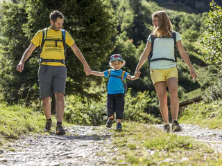
Südtirol Guide App Logo
Passer au contenu

ajouté(e) aux favoris

supprimé(e) des favoris

Oups ! Une erreur s’est produite. Réessayer

Ton compte est en cours de création

Ton compte a été créé avec succès et tu es maintenant connecté

Tu es connecté!

Ton compte a été créé avec succès, mais nous n'avons pas pu te connecter automatiquement

Tu es déconnecté

Filtrer
Filtres sélectionnés
    Niveau de difficulté
    Durée
    Distance en km

    Randonnée à Sterzing Vipiteno et dans les environs

    Le paysage est un cadeau dont tu peux profiter au mieux à pied. Au printemps dans le Sud-Tyrol, tu assistes au réveil de la nature dans la vallée et dans les prairies alpines en fleurs, tandis qu'en plein été, tu es attiré par les sommets aériens, les refuges recommandés et les randonnées en altitude. Les randonnées d'automne offrent une vue grandiose et des couleurs magnifiques. En hiver, la nature enneigée t'enveloppe lors de randonnées romantiques en raquettes et en hiver.
    Résultats
    Summer
    Excursion to the hut Ochsenalm
    Ratschings/Racines, Sterzing/Vipiteno and environs

    The hike starts at the fire station in Obertelfes/Telves di Sopra. Follow the comfortable path no. 5 for about one hour, evenly rising to the first mountain pasture, the Freundalm. Further on uphill on path no. 5 and no. 6, which lead to the mountain pasture Ochsenalm.
    Alternative: reachable also by using the cable car Rosskopf Monte Cavallo

    Difficulté : facile
    590 m altitude
    1h:58 min durée
    Summer
    To the pasture Edelweißhütte/Rifugio Stella Alpina
    Brenner/Brennero, Sterzing/Vipiteno and environs

    Starting point: mountain station Ladurns (1.713m)
    From the mountain station of the cable car Ladurns a path leads slightly ascending past the pasture village Ladurns with the farmed mountain hut Ladurnerhütte across the so-called “Mahder” to the mountain hut Edelweißhütte/Rifugio Stella Alpina. On the right there is an alp crucifix and behind it is located a little fishpond. There you can see a rock formation - the huge alpine massif of the summit Tribulaun. Although it is 3.100 high, it overshadows the remaining summits. Tip: delicious apple pie

    Looking for an hike with breathtaking views and a cozy stop? Then the trail from the Ladurns mountain station (1,713 m) to the Edelweisshütte is perfect. The trail takes you past the Ladurns mountain village and the Ladurnerhütte hut. From there, continue across the "Mahder" to the Edelweisshütte, which you can already see from afar. Along the way, you'll enjoy spectacular views of the impressive Pflerscher Tribulaun rock mass, which towers over the surrounding mountains.

    At the Edelweisshütte, you can take a break and admire the mountain cross and a small fish pond. Additionally, there's an opportunity to fish in the lake – the freshly caught fish will be prepared for you right on site by chef Luis. A special tip: enjoy the delicious apple strudel at the hut, which will perfectly round off your outing.

    Difficulté : moyenne
    245 m altitude
    0h:49 min durée
    Summer
    Excursion to the hut Outer Wumblsalm
    Ratschings/Racines, Sterzing/Vipiteno and environs

    The hiking tour to the mountain pasture Outer Wumblsalm (no service!) starts in Ratschings/Racines about 800 meters towards Bichl/Colle. There is a crossway, where a road branches off on the right side to the guesthouse Seeberhof. On the left side branches off the path no. 15 to the Outer Wumblsalm. Alternative: reachable also by using the cable car Ratschings-Jaufen across the Ratschinger Almenweg.


    Difficulté : facile
    547 m altitude
    1h:52 min durée
    Summer
    The Gurgl cascade
    Ratschings/Racines, Sterzing/Vipiteno and environs

    Experience close up the roaring cascade on the natural new created path! A pleasant hiking tour for the whole family. From the Obertal in Jaufental walk on the pasture road respectively the new created hiking trail towards the mountain pasture Bergalm. Along the path cross the Gurgl cascade, which rushes imposingly over rocky territories and pulverizes the water-molecule. Reached the Ontratt valley, the smooth mountain stream induces to a natural Kneipp adventure.

    Alternative: from Mittertal on the panoramic path towards the valley.

     
    Difficulté : facile
    296 m altitude
    1h:26 min durée
    Summer
    Excursion to the hut Aglsalm
    Ratschings/Racines, Sterzing/Vipiteno and environs
    From the head of the Ridnauntal valley, follow the hiking trail no. 9 through the forest to the entrance to the Burkhardklamm gorge and continue either along the gorge or left along the forest path to the water barrier at Aglsboden. At the eastern edge of the bottom, trail no. 9A branches off to the right from the main trail, which leads to the refugees and leads steeply up to the Aglsalm. The return follows the same route as the ascent.
    Difficulté : moyenne
    628 m altitude
    2h:02 min durée
    Summer
    Excursion to the hut Martalm
    Ratschings/Racines, Sterzing/Vipiteno and environs

    Starting point: Ridnaun/Val Ridanna – Maiern/Masseria (1.370m)
    From the park area at the village center of Maiern walk along the transit road to the Hotel Schneeberg, along the asphalted road to a fork, where you turn left and follow the signpost Martalm. Then continue on relatively flatter ground along the asphalted road, past the heating system of the Hotel Schneeberg, through an underpass and uphill in serpentines to the farm Staudnerhof. Pass the farmhouse and continue to walk on a gravel path in the Staudenberg valley. Along the river Staudenberg towards the valley to the first left bend and along a forest path following the signposts “Martalm”. After a short flat section you reach the mountain pasture.
    Alternative: starting from Bergl (1.560m) the walk time is about 30 minutes

    Difficulté : facile
    360 m altitude
    1h:23 min durée
    Summer
    Hike to pasture Kalcheralm
    Ratschings/Racines, Sterzing/Vipiteno and environs

    Ideal for those who do not like long hikes! Continue on the road Jaufenstraße with direction Jaufenpass by car or hiking shuttle. 2 km before the pass Jaufenpass a small road branches from the main road- well marked with "Kalcheralm". Right at the entrance is a large parking lot. From there it is only about 45 minutes to the pasture. 
    Tip: On the occasion you can also drive up to the alpine pass Jaufenpass and enjoy the magnificent panorama over the Passeiertal!
    Alternative: Take the mountain railway in Innerratschings, from there follow the sign Kalcheralm.

    Difficulté : facile
    93 m altitude
    1h:07 min durée
    Hiking
    Circular route Ladurns
    Brenner/Brennero, Sterzing/Vipiteno and environs

    The Ladurns Loop starts at the Ladurns mountain station (with dining options). The approximately 2-hour hike takes you past the Hirsch-Lacken, a biotope with two small lakes. You continue on the Dolomieu Trail until the junction to Teissljöchl/Edelweiß Hut. A short climb leads to Wastenegg, where you can enjoy a stunning panorama of the rugged Tribulaun peaks. Continuing with a gentle descent, you reach Teissljöchl and then turn left to the Edelweiß Hut, where you can rest and refuel. From here, you have two options to descend: either along the forest road marked with number 34 or along trail number 8 (starting behind the water reservoir of Ladurns), both leading back to the starting point.

    Difficulté : moyenne
    319 m altitude
    1h:51 min durée
    Summer
    Saxner
    Ratschings/Racines, Sterzing/Vipiteno and environs

    From the end of the valley Ratschings/Racines follow path no. 10, walk steeply at first through the mountain forest, then up through alpine meadows to the inner pasture of Wumblsalm. Following the mark you will reach the pass Schlotterjoch (2,283 m), left from here, on path no. 12 climb to the top of the mountain Saxner. From here you will enjoy a spectacular view, on a clear day as far as to the mountain Ortler-area! The decent follows the same route.

    Difficulté : moyenne
    1303 m altitude
    5h:45 min durée
    Hiking
    Circular snowshoe hike Mittertal / Val di Mezzo - Obertal / Val di Sopra
    Ratschings/Racines, Sterzing/Vipiteno and environs

    From the village of Mittertal/Val di Mezzo, follow the small road signposted “Hotel Jaufentalerhof”. Continue past the hotel and stay on the paved road until you reach Kaltenbrunn. There, turn right onto the forest road and continue straight ahead to the junction for the Ontrattal and Obertal valleys. Take the right fork towards Obertal/Val di Sopra. Follow the road out of the valley until the first hairpin bend, then continue straight ahead to the Steinhof farm. From there, walk through the forest to Dörfl and return to the starting point.

    Note: Although parts of the route are paved, it also leads through forest terrain – therefore snowshoes are required.

    Difficulté : moyenne
    557 m altitude
    2h:43 min durée
    Summer
    Tightrope walk Jaufenpass/Passo Giovo
    Ratschings/Racines, Sterzing/Vipiteno and environs

    Starting from the Jaufenpass/Passo Giovo (either by car to the pass or from Ratschings/Racines by using the cable car towards the Rinneralm and then by foot to the pass). In the second case there is an additional walking time of about 40-60 minutes. Path no. 12 over the Fleckernspitze, the Saxner, the Glaitnerjoch, the Schlotterjoch to the Kleine Kreuzspitze. From this down to Flading in the Ratschingstal Valley. In case you have parked your car at the Jaufenpass: to the Schlotterjoch, then on path no. 10 to the Innere Wumblsalm, from there on path no. 15 and then take path no. 13A back to the Jaufenpass. Surefootedness necessary!

    Difficulté : moyenne
    428 m altitude
    6h:00 min durée
    Summer
    Circular Hike in the Ridnauntal Valley
    Ratschings/Racines, Sterzing/Vipiteno and environs

    The trail starts from the mine at the top of the Ridnauntal valley and then continues across the Mareiterbach stream and down the valley to below Ridnaun/Ridanna. Then the trail takes you for about 20 minutes along marked route 7A up to the chapel. This can be visited every Monday at 4 pm from May to the end of October, and in July and August also on Fridays at 10 am.

    Difficulté : facile
    0 m altitude
    1h:30 min durée
    Summer
    Excursion to the hut Inner Wumblsalm
    Ratschings/Racines, Sterzing/Vipiteno and environs

    Starting from Innerratsching/Racines di Dentro, shortly after the farm “Pulvererhof” behind the Hotel Larchhof, follow the path no. 10, which leads over a bridge and then continue on a bit steeper path until you reach a tree line. Continue towards the mountain pasture Inner Wumblsalm. Alternative: reachable also by using the cable car Ratschings-Jaufen along the Ratschinger Almenweg.
    No service!

    Difficulté : facile
    504 m altitude
    1h:33 min durée
    Summer
    Excursion to the hut Aglsboden
    Ratschings/Racines, Sterzing/Vipiteno and environs

    From the valley head in Ridnaun/Ridanna hike along the path no. 9 through a forest towards the entrance of the Burkhardklamm gorge and continue either along the gorge or on the forest path at your left side to the water barrier of the Aglsboden. From there you can reach the mountain pasture Aglsbodenalm after a walk of 10 minutes on path no. 9.
    Alternative: reachable also starting from Maiern/Masseria and following the forest path (1,5h)

    Difficulté : facile
    330 m altitude
    1h:11 min durée
    Summer
    Mittagspitze
    Ratschings/Racines, Sterzing/Vipiteno and environs

    Starting point is the hamlet Schluppes at the end of the Jaufental valley. From this point first you go 600 meters along a forest and then on the path no. 12 further into the valley. Turn left at the sign Mittagsspitze/no. 16 and walk up the quite steep way through the mountain forest. Continue on the marked trail over the tree line and towards the avalanche barrier under the mountain Mittagsspitze. The last piece again steeply along the ridge, to the summit cross at 2052 m. Hike the same path back to reach the starting point.

    Difficulté : moyenne
    710 m altitude
    2h:53 min durée
    Hiking
    Winter hike from Maiern to the Untere Gewingesalm mountain hut
    Ratschings/Racines, Sterzing/Vipiteno and environs

    From Maiern/Masseria, behind the Hotel Schneeberg (1,400 m), follow the signs for “Untere Gewingesalm”: First head south across the open valley floor to the edge of the forest, then ascend via a wide, groomed forest road in several switchbacks through wooded slopes. The Untere Gewingesalm alpine hut (1,782 m) is located at the tree line.
    Return along the same route – either on foot or by toboggan.

    Difficulté : moyenne
    404 m altitude
    2h:43 min durée
    Summer
    Adventure trail "On the trail of water"
    Brenner/Brennero, Sterzing/Vipiteno and environs

    This adventurous family hike on the South Tyrolean side runs along the banks of the Pflerscherbach stream and features various play stations on the theme of ‘water’ and ‘climbing’. The educational hike with the two water drops Gossy and Gschnitzy starts at the sports field in Gossensass and leads to Innerpflersch to the viewing platform Hölle. To get back to the starting point, you can take the public bus number 313 every hour. On this easy yet long adventure trail, you have several opportunities to stop for refreshments or to enjoy a cosy picnic. 

    Difficulté : facile
    433 m altitude
    3h:40 min durée
    Summer
    Excursion to the hut Wasserfalleralm
    Ratschings/Racines, Sterzing/Vipiteno and environs

    The cable car Ratschings-Jaufen takes you from Bichl to the mountain station. From there you can hike along the Ratschinger Almenweg to the mountain pasture Wasserfalleralm.

    Difficulté : facile
    74 m altitude
    0h:19 min durée
    Summer
    Kleine Kreuzspitze
    Ratschings/Racines, Sterzing/Vipiteno and environs

    Starting from Flading at the end of the Ratschingstal , walk first through a forest ascending on path no. 12. Then steep over meadows to the pasture Klammalm (1925m). From there forward on path no. 12B over meadows until the climb beneath the summit gets steep. On it up to the summit of the Kleine Kreuzspitze with summit cross. The return follows the same route as the ascent.  Exposed and brittle rocky ridge! Surefootedness necessary!

    Difficulté : moyenne
    1032 m altitude
    3h:51 min durée
    Summer
    To the mountain hut Hühnerspiel/Gallina
    Brenner/Brennero, Sterzing/Vipiteno and environs

    The starting point is the Gossensass parking lot in the town center at Ibsen Square (1,098 m). From Ibsen Square, the trail leads north to the Raiffeisen Bank, where you cross the pedestrian crossing to reach the "Alte Postgasse" Alley. Then, head east, climbing uphill, passing the Aparthotel Pichler on the left. At the intersection, you will find the trail signs, and from there, Trail No. 22 leads up to the mountain hut Hühnerspielhütte (1,868 m).

    Variant:
    From Sterzing, drive on the state road towards Brenner. After about 4 km, you will reach the village of Gossensass. Continue on the road for another 3 km until you reach a sharp S-curve (first a right turn, then a left turn). In the left curve, you will find an exit for the highway on the right, and right next to it, a narrow asphalted road. Follow this road for about 800 m to reach the DAX parking lot. From there, continue on foot along a forest road to the hut.

    Difficulté : moyenne
    797 m altitude
    3h:15 min durée
    Summer
    MountainAdventure Ratschings/Racines
    Ratschings/Racines, Sterzing/Vipiteno and environs

    The tour “Mountain Adventure World” starts directly at the mountain station of the cable car Ratschings-Jaufen on a good, suitable for buggies, path. This tour can easily be covered at an altitude difference of 50 meters in about 45 minutes and is therefore ideal especially for families with children. The adventurous hiking trail surprises with numerous attractions, like the ant words, the marmot world, the petting zoo, funny water games, the penguin giant, surprising climbing scaffolds, viewing bridges and rest points in the mountain pastures. At many locations there are educational signposts, that inform about the local flora and fauna and satisfy the thirst of knowledge of nature lovers.

    Difficulté : facile
    48 m altitude
    0h:45 min durée
    Hiking
    Winter hike to Bergl
    Ratschings/Racines, Sterzing/Vipiteno and environs
    This hike starts in Maiern/Masseria and leads through peaceful winter landscapes in a quiet setting. The route is ideal for anyone looking for a relaxed tour away from the main paths.
    Difficulté : facile
    203 m altitude
    1h:28 min durée
    Hiking
    Winter hike to the Wurzeralm mountain hut
    Ratschings/Racines, Sterzing/Vipiteno and environs
    Dal villaggio „Gasse“ a Ridanna sulla strada asfaltata verso sud fino al gruppo di masi Entholz. Da lì il sentiero n. 25 attraversa il bosco in direzione della malga Wurzeralm (without service). Il ritorno avviene lungo lo stesso percorso – a scelta a piedi o con lo slittino.
    Difficulté : moyenne
    494 m altitude
    2h:22 min durée
    Summer
    Mountain Einachtspitze
    Ratschings/Racines, Sterzing/Vipiteno and environs

    From the hamlet Gasse in the valley Ridnauntal past the farm group Entholz. Go up on path no. 24 through meadows and woods to the pasture Joggelealm. Passing the pasture Joggelealm, the path continues to the lake Fuchssee, from there following the markings to the small summit plateau with a new summit cross. The return follows the same route as the ascent.

    Variant: From the valley Ridnauntal follow path no. 26 through the valley of Valtigl until shortly before the pass. Then follow a wellmarked path without numbering alongside the pastures to the rewarding panoramic mountain Einachspitz. From there follow the red-white marking, past the small lake Fuchsee, through the mountain pasture Joggelealm and the new forest road to the starting point.

    Difficulté : moyenne
    1005 m altitude
    4h:13 min durée
    Hiking
    Winter hike from Telves to the Freundalm mountain hut
    Ratschings/Racines, Sterzing/Vipiteno and environs

    From Obertelfes/Telves di Sopra (1,258 m, at the village fountain with several signposts), follow the signs for “Telfer Almen” or “Freundalm”. First, take the narrow farm road to Kappelerhof (1,353 m), then continue on a wide, cleared hiking and sledding path through meadows and forest with a moderate ascent northwestwards. Finally, cross open meadows to reach Freundalm alpine hut (approx. 1,720 m). The return follows the same route and can be done either on foot or by sled.

    Difficulté : moyenne
    471 m altitude
    2h:16 min durée
    Summer
    Excursion to the hut Kuhalm
    Ratschings/Racines, Sterzing/Vipiteno and environs

    This hike starts at the fire station in Obertelfes/Telves di Sopra. Follow the path no. 5 for about 1,5 hours upwards to the first mountain pasture, the Freundalm. Continue on path no. 5 until you reach a fork, from where you turn right to path no. 5A and shortly thereafter reach the mountain pasture Kuhalm.
    Alternative: reachable also over the mountain railway station Rosskopf Monte Cavallo in about 45 minutes across the panoramic trail.

    Difficulté : facile
    668 m altitude
    2h:12 min durée
    Hiking
    Excursion to the hut Valtiglalm
    Ratschings/Racines, Sterzing/Vipiteno and environs

    The hiking tour starts in Gasse in Ridnaun/Ridanna. You can also take the car and drive on for about 15 minutes. Turn left towards “Entholz” and at the sign to the Valtiglalm drive on about 2 kilometers until you reach a wooden bridge, where you can park your car. Then follow the path no. 26 upwards to the mountain pasture Valtiglalm.

    Difficulté : facile
    214 m altitude
    0h:42 min durée
    Summer
    Mareiter Stein
    Ratschings/Racines, Sterzing/Vipiteno and environs

    Starting from Pardaun/farm Platzhof (parking in Pardaun, no available parking at the farm Platzhof). In front of the farm Platzhof to the left, at first follow a wider path, no. 25, which tightens to a narrow path through the woods and leads into a steeper climb towards the timberline. Then with a wonderful panoramic view along the broad ridge of the mountain to the large summit plateau with its cross. The return follows the same route as the ascent.

    Variant: Starting from Gasse/Entholz along the path no. 24 and later on the path no. 25 to the pasture Wurzeralm. Always on path no. 25 it goes up to the Mareiter Stein. The return goes first on the path no. 25 and then on path no. 25B to the pasture Kerschbaumeralm. Contiune on path no. 23 to the Joggelealm and in the descent briefly on path 24B and 24A down to Gasse. Duration 5 hours.

    Difficulté : moyenne
    1104 m altitude
    6h:30 min durée
    Summer
    Excursion to the hut Rinner
    Ratschings/Racines, Sterzing/Vipiteno and environs

    The cable car Ratschings-Jaufen takes you from Bichl/Colle to the mountain station. From there you hike along the Ratschinger Almenweg to the mountain pasture Rinneralm. Alternative: visit the Mountain Adventure World Racines

    Difficulté : facile
    55 m altitude
    0h:12 min durée
    Hiking
    Winter hike from Gasteig to Mareit
    Ratschings/Racines, Sterzing/Vipiteno and environs

    This hike starts in Gasteig/Casateia and follows the snowy Mareiter Bach stream all the way to Mareit/Mareta. Along the way, you pass the village of Stange/Stanghe, which can also be used as an alternative starting point to shorten the tour. Especially on warm, sunny days, the icicles and frozen water surfaces offer an impressive natural spectacle.

    Difficulté : facile
    104 m altitude
    2h:37 min durée
    1 2 3 4 5 6