Passer au contenu
ajouté(e) aux favoris
supprimé(e) des favoris
Oups ! Une erreur s’est produite. Réessayer
Ton compte est en cours de création
Ton compte a été créé avec succès et tu es maintenant connecté
Tu es déconnecté
Filtrer
Filtres sélectionnés
    Niveau de difficulté
    Durée
    Distance en km

    Circuits VTT et trails dans le Sud-Tyrol

    De l'adrénaline à l'état pur devant un décor de montagne impressionnant. Les tours en VTT dans le Sud-Tyrol offrent du plaisir à tous les vététistes. En piste, c'est parti ! Explorez en tant que freerider les versants de la vallée du Vinschgau, découvrez l'Alpe de Siusi, le plus grand alpage d'Europe, sur deux roues ou sentez le vent souffler sur vous lors d'une descente endiablée du Kronplatz. Les circuits VTT du Sud-Tyrol garantissent le plaisir de rouler et de découvrir la nature.
    Résultats
    Mountain bike
    Freeride Ciampinoi
    Sëlva/Selva, Dolomites Region Val Gardena

    The freeride track is unique in the whole valley. It starts from the mountain station of the Ciampinoi and leads you down until the Pra Valentini hut. The track was built in the woods and the ride down to the bottom is for everyone an unforgettable experience.

    Difficulté : facile
    5 altitude
    2.4 Km distance
    Mountain bike
    Latscher Panorama Trail
    Latsch/Laces, Vinschgau/Val Venosta

    A fireworks of trails for experts with head for heights due to exposed S3-G5 passages at the Laces panoramic trail. S2 at the successive Propain trail.

    The name of the Laces panoramic trail says it: the panorama is amazing. But this trail is also simply marvelous as it includes everything from technical and exposed passages with hairpins to flowing forest trails and stepped passages. Start at the mountain station of San Martino in Monte (1,740 m). First take the asphalt road and then the gravel hiking path no. 14. After about 2.5 km, the actual trail begins shortly after the Egghof.
    Please note: There is a time regulation from 10 a.m. to 2 p.m. for hikers only!
    The partially rather exposed path with some technical passages takes you along the slope passing by the Laggar and Zuckbichl ruins. You will be overwhelmed by the wonderful panorama again and again. After a few flow sections, steep hairpins and a short stretch where bikes have to be carried (S3-S4) you get to a forest road and can start the propain trail shortly after Patsch.

    The trail becomes more flowing but with many narrow turns on the beautiful trail floor of Val Venosta’s Sun Mountain. The sunny slope declines sharply near the trail and clearings offer views of the apple orchards and the fantastic mountain world. This trail section of 550 depth meters was built with a width of 80 cm and thus offers security to beginners and leaves space for speed and airtime to experts. If you don’t want to get off the bike, a good turn technique and back wheel lifting are required in narrow turns. You can stop for a refreshment with view at Fisolgut near Castel Schlandersberg with a few extra meters.

    Several “Share the Trail” sections are marked. The rest of trail no. 14 as well as trail no. 7 are for hikers only!

    Difficulté : facile
    50 altitude
    2.8 Km distance
    Mountain bike
    E-Bike Tour Albeins-Nafen-St. Peter-Ranui
    Villnöss/Funes, Dolomites Region Villnösstal

    Enjoy mountain bike tours also on steeper trails with the latest e-bike. Even beginners will be impressed by the electric mobility! Explore effortlessly the Geisler mountain landscape with an E-Bike. It’s emission-free, climate-friendly and without being stiff and sore.
    E-Bikes are for everyone due to the very simple operation. Overcome steep inclines with ease and cycle into the wind with a smile on your face, because that makes your bike trip even more fun.

    Difficulté : facile
    1082 altitude
    23.1 Km distance
    Mountain bike
    Bosco di Monticolo
    Eppan an der Weinstaße/Appiano sulla Strada del Vino, The South Tyrolean Wine Road
    Wild trails, forestry routes or flow trails - Montiggl Forest is a sensational mountain bike territory.
    Difficulté : facile
    306 altitude
    14.1 Km distance
    Mountain bike
    255 Schnaggenkreuz Cross loop route
    Völs am Schlern/Fiè allo Sciliar, Dolomites Region Seiser Alm

    The Schnaggenkreuz Cross loop route begins in Völs am Schlern and passes by the hamlets of Umes, Völser Aicha and Prösels, offering immense variety and close contact with the surrounding countryside. In Prösels, it is well worth taking a detour to the historic Prösels Castel, which organises fascinating guided tours.   

    Difficulté : facile
    570 altitude
    16.6 Km distance
    Cycling
    Pustertal Valley Bike Route Leg Bruneck - Franzenfeste
    Innichen/San Candido, Brixen/Bressanone and environs

    The Brunico|Bruneck to Fortezza|Franzensfeste leg is rich in cultural and historical treasures that make the route unique. The settlements, fortresses, and historical monuments from Roman times through the Middle Ages line the bike path along the Rienza|Rienz, offering interesting insights into the history of the valley.

    Difficulté : facile
    369 altitude
    34.8 Km distance
    Mountain bike
    285 Tagusens Tour with Moosbühel variant
    Kastelruth/Castelrotto, Dolomites Region Seiser Alm

    The Moosbühel variant of the route leads between the Rendenbühl and Tisenser Bühel hills, and offers a shorter version of the traditional Tagusens loop route. The trail is relatively flat and leads mainly through woodland.

    Difficulté : facile
    76 altitude
    4.8 Km distance
    Cycling
    Pustertal Valley Bike Route : Leg Innichen - Bruneck
    Toblach/Dobbiaco, Brixen/Bressanone and environs

    On the San Candido|Innichen to Brunico|Bruneck leg, the green color of the meadows, fields, and forests dominates the view. Along the railway route, sometimes through inhabited areas and sometimes through an undisturbed natural landscape, the bike path runs with a constant up and down from village to village as far as Brunico, the economic center of the Pustertal|Val Pusteria. 

    Difficulté : facile
    684 altitude
    35.0 Km distance
    Cycling
    211 Paravis Trail
    Sëlva/Selva, Dolomites Region Val Gardena

    An absolute pleasure trail: flowing and embedded in the beautiful Dolomite landscape, the Paravis Trail winds its way from the mountain station of the Gran Paradiso chairlift, at the highest point of the famous Città dei Sassi (Stone City), to the valley station. The Ladin name Paravis stands for paradise and the trail lives up to its name, as it is constantly accompanied by paradisiacal views of the Sella massif and the Sassolungo. Fun for big and small bikers alike, and anyone sitting on the chairlift can often hear the bikers whooping with joy on the trail.

    Difficulté : facile
    2433 altitude
    2.8 Km distance
    Mountain bike
    429 Variante Schnaggenkreuz Cross loop route I
    Völs am Schlern/Fiè allo Sciliar, Dolomites Region Seiser Alm

    At the Braunhof farm there is a connection from the Hofer Alpl hut loop tour to the entrance of the Schnaggenkreuz loop route at the Tasioler farm. So you can quickly and comfortably switch between the tours.

    Difficulté : facile
    0 altitude
    376.0 m distance
    Mountain bike
    Montesole (Sunny Benny) Trail
    Latsch/Laces, Vinschgau/Val Venosta

    "One of the most beautiful trails in the Alps" – this is how Bike Magazine described the Montesole /Sunny Benny Trail in Val Venosta.

    This trail is passable nearly all year round and takes you through the austere cultural landscape of Val Venosta’s Sun Mountain. You will not only enjoy the flowing passages, but also the fantastic panoramic views of Monte Tramontana and of the surrounding mountain peaks and glaciers. Start at the mountain station in San Martino in Monte and follow the asphalt road downhill. Turn right after 1.2 km and take hiking path no. 9 for the first broader warm-up trail passage. The main part of the trail with flowing forest floors and more difficult stone passages (partially S2) starts after a short asphalt road crossing at Birchaböden. Look forward to pure trail fun after a short crosswise drive on the Ratschillweg road to the newly built trail section with fantastic steep turns. The successive flatter, flowing “Share the Trail” section starts after a few meters in altitude and takes you along Piani di Annenerg. Continue until the suspension bridge, pass by the cairns and take the partially steep path no. 5 to Tiss. Variant: You can also take path no. 5A to Tiss, just before the suspension bridge. Return on the asphalt road towards Laces or Coldrano. Please note: “Share the Trail” sections for some parts, especially on paths no. 5 and 7. Please show consideration for hikers as they have right of way!


    Difficulté : facile
    0 altitude
    6.0 Km distance
    Cycling
    Brenner-Bozen Bicycle Route
    Mühlbach/Rio di Pusteria, Brixen/Bressanone and environs

    This bike route through the Isarco Valley is a pleasure tour that offers idyllic scenery. Rolling hills, small towns and cultural treasures line this well-marked bike route, which leads from Brennero to South Tyrol’s capital city of Bolzano. The Brennero/Brenner–Bolzano/Bozen Bike Route starts at the Brenner Pass and runs along the former railway line, which is at a slight downhill grade, to Vipiteno/Sterzing. The marked bike path then continues, partly flat and with a light ascent, through picturesque villages and small hamlets up to Franzensfeste Fortress, past Lake Vahrn, and along the Kastanienweg (Chestnut) Trail towards Novacella/Neustift Abbey and then continuing on towards Bressanone/Brixen. The section from Bressanone to Bolzano is again a brisk ride through the narrow Isarco Valley, with a stopover in the little artists’ town of Chiusa/Klausen, known for its imposing hilltop Säben Abbey. From there, the route continues to the capital city of Bolzano. The Brennero/Brenner–Bolzano/Bozen Bike Route runs a total length of 96 kilometers from Brennero to Bolzano.

    Difficulté : facile
    327 altitude
    103 Km distance
    Cycling
    Bike route Tauferer Ahrntal
    Sand in Taufers/Campo Tures, Brixen/Bressanone and environs

    The “Ahrtour” bike route runs through the entire Valli di Tures Aurina - Tauferer Ahrntal and promises an adventurous trip through nature itself. From the start in Brunico - Bruneck until Campo Tures - Sand in Taufers, the Ahrtour is a fairly flat and easy ride. This bike tour is an adventure for athletes and amateur bikers alike and of course it can also be enjoyed in individual sections.

    Difficulté : moyenne
    92 altitude
    15.9 Km distance
    Mountain bike
    430 Variante Schnaggenkreuz Cross loop route II
    Völs am Schlern/Fiè allo Sciliar, Dolomites Region Seiser Alm

    The 600 m long Hofer Alpl II variant is a connection from Moar Mühle to Peternaderhof farm, where you can enter in the Schnaggenkreuz loop rout or vice versa.

    Difficulté : facile
    0 altitude
    599.0 m distance
    Cycling
    Connection path Malga Tarres and Malga Laces
    Latsch/Laces, Vinschgau/Val Venosta

    Short, but exerting connection with the Tarres alp abouth the "Schwellerweg".

    Optimally to cobine various Trails. At the crossroad with the Laces alp it goes first moderately precipitously, then level and then again a little more precipitously high to the Tarres alp.

    Difficulté : facile
    231 altitude
    2.4 Km distance
    Mountain bike
    260 Tagusens loop route
    Kastelruth/Castelrotto, Dolomites Region Seiser Alm

    The natural landscape of the Tagusens loop route offers endless variety, and leads along meadows, woods and forest trails past the two hamlets of Tisens and Tagusens. At 12.8 km it is a moderately difficult tour, but the Moosbühel route offers a shorter alternative.

    Difficulté : facile
    500 altitude
    12.9 Km distance
    Mountain bike
    249 Hofer Alpl loop route
    Völs am Schlern/Fiè allo Sciliar, Dolomites Region Seiser Alm

    This tour takes you along forest roads through masses of woodland to the Schlern-Rosengarten nature reserve. The trail leads past the Völser Weiher Lake and the Tuff Alm hut mountain hut to the Hofer Alpl on the slopes of the Schlern.

    Difficulté : facile
    684 altitude
    16.6 Km distance
    Mountain bike
    259 St. Oswald-Tour
    Kastelruth/Castelrotto, Dolomites Region Seiser Alm

    This route from Kastelruth village centre to Seis am Schlern passes through the picturesque hamlets of Tisens and St. Oswald with their small chapels, the fascinating natural spectacle of the “Ice Hole” wind tunnels, the ruins of Aichach and the Malenger water mill. The route leads, in part, along ancient roads with tracks that have been worn down over the centuries and offers beautiful views over the Eisacktal, the Ritten and, naturally, the Schlern and its neighbouring mountains.
    ATTENTION: the section from km 3.2 to km 4.2 is very steep (downhill) and narrow!

    Difficulté : facile
    659 altitude
    16.5 Km distance
    Cycling
    Laces round
    Latsch/Laces, Vinschgau/Val Venosta

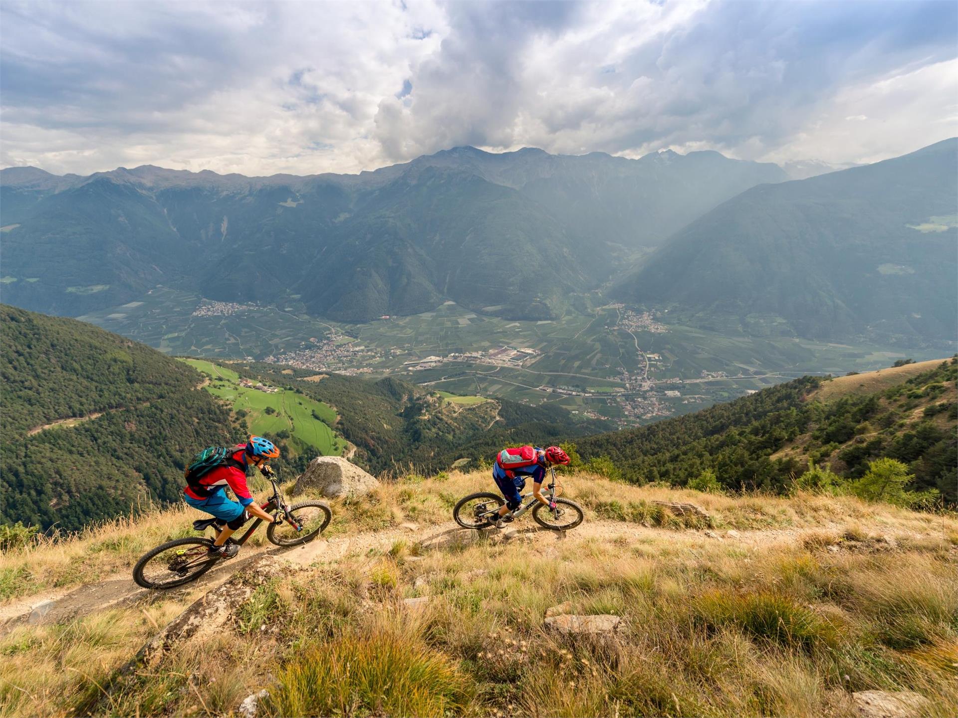
    A flowing trailround without great increases. Shady forests at Monte Tramontana, closed forest roads, short single trails, green meadows in the valley basin and sunny slopes at Monte Sole.

    This 20 km-long tour is characterized by its great variety, which you can only find in Val Venosta Valley. The tour starts in Laces and takes you to Tiss and Coldrano along the slopes of Monte Sole. Pass by Coldrano Castle, continue to the Tschanderle hamlet and cross the river. The tour then takes you through the village of Vezzano and back to Coldrano where you continue through orchards until you reach the Holzbrugg bridge. Take the forest road and then the single trail along Monte Tramontana to the weather cross above Morter. Cross the village of Morter and go towards Val Martello until you reach the junction for Montani Castle.

    In 2002, the Trans Alp race led along this irrigation channel path until the so-called Magrin Böden. You then continue on the "Südtirol Cup" route until the ice rink and the asphalt road. Cross the recreation area in Laces and return to your starting point.

    Difficulté : facile
    214 altitude
    15.0 Km distance
    1 2 3 4 5 6 7 8 9 10 11 12 13