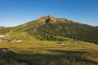
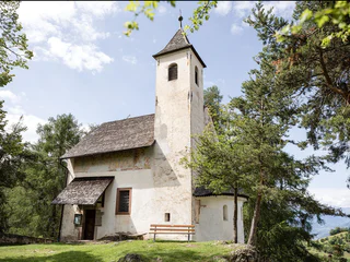
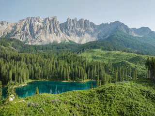
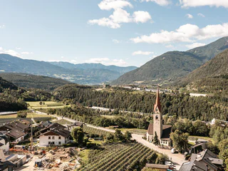
Südtirol Guide App Logo
Passer au contenu

ajouté(e) aux favoris

supprimé(e) des favoris

Oups ! Une erreur s’est produite. Réessayer

Ton compte est en cours de création

Ton compte a été créé avec succès et tu es maintenant connecté

Tu es connecté!

Ton compte a été créé avec succès, mais nous n'avons pas pu te connecter automatiquement

Tu es déconnecté

Filtrer
Filtres sélectionnés
    Niveau de difficulté
    Durée
    Distance en km

    Randonnée en poussette dans le Sud-Tyrol

    Découvrez le Sud-Tyrol avec toute la famille. Nos sentiers et destinations adaptés aux poussettes vous permettront, à vous et à vos enfants, de vivre des expériences inoubliables dans la nature époustouflante du Sud-Tyrol
    Résultats
    Summer
    Around Trodena/Trodena
    Truden/Trodena
    Due to its isolated position, Trodena still retained many testimonies of what men have conceived, built and transformed here over the centuries. On the circular route of Trodena we will learn about the centuries-old urban culture. From the town square we move towards the upper part of the town, pass in front of a 700-year-old lime tree and walk along the paved road up to the entrance to the town. From there we follow trail marker 3 to a parking lot. From the panoramic road (3A) we come to a viewing platform, a sort of balcony. from which we can admire the "3 horns": Corno Nero, Corno Bianco and Monte Corno. This is where the geological "line" of Trodena develops. The view over the roofs of Trodena testifies to the division of the farms that has taken place for generations. We then walk until we reach the Via Cislon. From here we follow trail no. 1 to return to the starting point of Trodena, which we will reach through the historic center.
    Tip: take a walk in the village to discover the "The walls tell" project ... The brochure is available at the tourist office. Also discover the Monte Corno Visitor Center
    Difficulté : facile
    76 m altitude
    0h:31 min durée
    Summer
    The Andreas Hofer Trail from St. Leonhard/S. Leonardo
    St.Leonhard in Passeier/San Leonardo in Passiria, Meran/Merano and environs

    This easy circular route starts at the Tourist Office in San Leonardo. Crossing the steel bridge (above the bus station), follow the road on the right all the way up to the church. The route then passes the Brühwirt Restaurant leading right up to the primary school buildings. Turn right and take the Happergweg road as far as the Happerg farm at the edge of the forest. Follow the signs to the Andreas-Hofer-Rundweg circuit until Gerlosweg/Via Gerlos road then turn right across the main street and continue to the historic Sandwirt farm, Andreas Hofer’s place of birth and the museum named after him. The route back to San Leonardo follows the Gandellenweg road, under the main road.

    Difficulté : facile
    102 m altitude
    1h:30 min durée
    Summer
    Circular hike tour from Schenna on the Blosegg hiking path
    Schenna/Scena, Meran/Merano and environs
    This leisurely circular hike leads from Schenna through the apple orchards along the Bloseggweg hiking path, continuing to the Kampflkreuz, and then back via the Mitterplattweg hiking path. Due to the nature of the path, it is also suitable for strollers. This circular hike is especially recommended in the spring during the apple blossom and in the autumn during the harvest season.
    Difficulté : facile
    200 m altitude
    1h:45 min durée
    Summer
    The Tschon boulder on the Seiser Alm
    Kastelruth/Castelrotto, Dolomites Region Seiser Alm
    Relaxed family-friendly circular hike to Panorama, Spitzbühl and back to Compatsch.
    If you walk from Compatsch towards Saltria on the tarred road, after around 600 m you will come to an immense boulder on the left-hand side of the road.

    This hiking tour can be found in the family hiking booklet “Out and About with Nix the Witch”.
    Difficulté : facile
    194 m altitude
    2h:10 min durée
    Summer
    S. Valburga Kneippweg Trail
    Ulten/Ultimo, Meran/Merano and environs

    A flat-surfaced, shaded, idyllic path along the lakeshore of the Zoggler reservoir with 6 stations with sculptures on the subject of Kneipp, a central water basin, loungers, tables, benches, a fountain, a mill by the stream...

    Difficulté : facile
    0 m altitude
    0h:49 min durée
    Summer
    Gitschberg Sun Park
    Vintl/Vandoies, Brixen/Bressanone and environs

    The  Gitschberg Sun Park is the perfect destination for families looking to experience summer in the mountains. With a wide variety of play areas and breathtaking views, the park is an unforgettable experience for both young and old.

    Difficulté : facile
    98 m altitude
    0h:19 min durée
    Summer
    Vorbichl Adventure Trail
    Tisens/Tesimo, Meran/Merano and environs

    The "Vorbichl" Adventure Trail is located in Prissiano. This path is ideal for children and adults. 

    Difficulté : facile
    162 m altitude
    1h:13 min durée
    Summer
    Nössler path
    Rasen-Antholz/Rasun Anterselva, Dolomites Region Kronplatz/Plan de Corones

    From Antholz Niedertal > path n. 15 to the Dörfl > Nösslerhof > Berghotel Johanneshof > and back on the main road to the starting point. 

    Difficulté : facile
    173 m altitude
    1h:15 min durée
    Summer
    Compatsch - to the Refuge Molignon
    Kastelruth/Castelrotto, Dolomites Region Seiser Alm
    Family-friendly hike along numerous huts to the Molignon Refuge. The path is passable with a pram. You have a wonderful view of the Rosszähne and the Langkofel and Plattkofel.
    Difficulté : moyenne
    403 m altitude
    3h:25 min durée
    Summer
    The fabulous world of Toni
    Ritten/Renon, Bolzano/Bozen and environs
    The fabulous world of Toni on the Corno del Renon. 
    Eagle eyes and eagle's nest, King Laurin and his Catinaccio, Eagle's lookout, Willeweis an her view, Tonis water geames, witsches of the sciliars dance, vrave knight prack, Tonis files, nörggelen are bowling, cave of the glant...
    Difficulté : facile
    63 m altitude
    0h:37 min durée
    Summer
    Jochtal adventure park
    Mühlbach/Rio di Pusteria, Brixen/Bressanone and environs

    The Jochtal Adventure Park offers a fun-filled family hike combining nature, interactive activities, and incredible views. Perfect for those who enjoy exploring and experiencing the outdoors.

    Difficulté : facile
    151 m altitude
    1h:07 min durée
    Summer
    A walk through the farms of Mölten
    Mölten/Meltina, Bolzano/Bozen and environs
    The hike through the Mölten farm landscape starts in the center of Mölten (1140 m) and leads past beautiful farms with a wide view into the valley.
    Difficulté : moyenne
    341 m altitude
    2h:23 min durée
    Summer
    Mushroom trail in Pfitsch Valley
    Pfitsch/Val di Vizze, Sterzing/Vipiteno and environs

    The new Mushroom Trail starts at the kids playground "Aue"in St. Jakob in the Pfitsch Valley near Sterzing and extends one kilometer through the forest. Information panels along the themed trail inform hikers about the world of mushrooms, their reproduction, and their uses.

    The life-sized mushrooms were mainly crafted from wooden elements with a uniform design to ensure recognizability along the entire themed trail. The Mushroom Trail is easy for everyone to walk and offers children and school groups the unique opportunity to learn about the life of mushrooms. Additionally, the themed trail provides visitors with an interesting recreational activity in the forests of the Pfitsch Valley.

    This project was realized by the Tourism Cooperative of Sterzing – Pfitsch – Freienfeld.

    Difficulté : facile
    38 m altitude
    0h:25 min durée
    Summer
    Family hike: Source of the Drava (Drau) River
    Innichen/San Candido, Dolomites Region 3 Zinnen

    A very easy family hike with no significant inclines. The outward route goes almost entirely through woods, a very peaceful setting. The destination is the source of the Drava river between San Candido/Innichen and Dobbiaco/Toblach. You can drink the water directly from the little fountain: you're unlikely to find fresher, clearer water anywhere.

    Difficulté : facile
    0 m altitude
    0h:45 min durée
    Summer
    Niederrasen - Oberstall - Oberrasen
    Rasen-Antholz/Rasun Anterselva, Dolomites Region Kronplatz/Plan de Corones

    From Niederrasen > passing the church > continue on the asphaltic road on the edge of the woods (mark n. 20) > Oberstallerhöfe > path of return following mark n. 5 > Oberrasen. 

    Difficulté : moyenne
    166 m altitude
    1h:00 min durée
    Summer
    Compatsch - Wiedner Eck
    Kastelruth/Castelrotto, Dolomites Region Seiser Alm
    Relaxing family and circular hike with a stunning view of Saltria, the Rosszähne, and the Molignon. From Compatsch to Wiedner Eck and from there towards Panorama. Despite the few meters of elevation gain, once you reach the Panorama, you will be rewarded with a breathtaking view. This route is also very suitable for strollers, up to the Panorama and back to the starting point.
    Difficulté : moyenne
    138 m altitude
    1h:53 min durée
    Summer
    Pfeifer Huisele path
    Ratschings/Racines, Sterzing/Vipiteno and environs

    Starting at the inn Jaufensteg, the Pfeifer-Huisile-Path leads along the valley path to Bichl/Colle and on to Vallettina, where the ruins of the birthplace of the sorcerer can be seen. The "Pfeifer Huisele", which was above all distinguished by his humour, is without doubt one of the most famous Tyrolean mythical figures. In the manner of Till Eulenspiegel, a well-known folklore character from northern Germany, he roamed through valleys and mountains on his little donkey. His ideas were so whimsical that you can still laugh about them today. Along the way, several information signs in text and pictures inform about the life of the Pfeifer Huisile. To get back to the starting point, you can either walk back the same way or take the public bus from Larchhof. 

    Difficulté : facile
    336 m altitude
    2h:34 min durée
    Summer
    trail "mountain pine"
    Villanders/Villandro, Brixen/Bressanone and environs

    Trail "mountain pine" e distillery Mountain Pine - Villanderer Alps

    Difficulté : facile
    203 m altitude
    1h:48 min durée
    Summer
    Niederrasen - Neunhäusern
    Olang/Valdaora, Dolomites Region Kronplatz/Plan de Corones

    From Niederrasen > Camping Corones > foresty road in the woods > Neunhäusern.

    Caution: use the path under the bridge of the statal road.

    Difficulté : facile
    26 m altitude
    0h:45 min durée
    Summer
    Family walking tour: Toblach/Dobbiaco - Toblach/Dobbiaco lake - Nature Educational Trail - Toblach
    Toblach/Dobbiaco, Dolomites Region 3 Zinnen

    This family hike leads around the beautifully situated Toblacher See. A nature adventure trail with 11 stations around the lake provides valuable information about the flora, fauna and geomorphology of the area and, above all, explains the special features of Lake Dobbiaco. The viewing platform on the west bank offers a place to rest and a view of the flora and fauna and the silting zone. In addition, the special and very varied panorama of the circular route should be mentioned.


    Suitable for pushchairs


    Further information on the Toblacher water treasures:

    https://www.drei-zinnen.info/de/toblach/toblach/toblach-erleben/toblacher-see-duerrensee-toblacher-wasserschaetze.html


    Difficulté : facile
    61 m altitude
    2h:30 min durée
    Summer
    Castle trail San Genesio variation C
    Bolzano/Bozen, Bolzano/Bozen and environs

    Arrival by own car at the public parking space of Cologna. Subsequently on the path n. 9 and n. 11 to the restaurant Noafer and then to the castle ruin Grifo/Greifenstein. (enter at your own risk!)

    After visiting the castle ruin Grifo/Greifenstein, turn back to the path n. 9 and walk up to the farm Moar in Rumsein. 

    Between the restaurant Noafer and the farm Moar in Rumsein, exists a particular route (walking duration 1 hour), which is very suitable for buggies!

    From the farm Moar in Rumsein, continue to the Restaurant Plattner, the high point of this hike.

    From the restaurant Plattner, you can enjoy the incredible view overlooking the whole city of Bolzano and the beautiful Etsch/Adige Valley!  

    After this climax of hiking, you can turn back to the Car Parking space Cologna on the path n. 5. 

    Approx. walking duration: 3.30 hour


    Difficulté : moyenne
    512 m altitude
    3h:17 min durée
    Summer
    Hofstatt Alm Hut
    Rasen-Antholz/Rasun Anterselva, Dolomites Region Kronplatz/Plan de Corones

    From Antholz Niedertal (towards the fishpond or starting from Walderhöfe) follow the mark n. 31b > Hofstatt Alm.

    Difficulté : facile
    243 m altitude
    0h:55 min durée
    Summer
    Geo-Trail - Circular hike lake "Mesner Lacke"
    Villnöss/Funes, Dolomites Region Villnösstal

    A relaxing stroll to the lake “Mesner Låcke” which is surrounded by a circular path with information boards about geology of the area. The path is accessible for wheelchairs and buggies!

    Difficulté : facile
    0 m altitude
    0h:10 min durée
    Summer
    Geologic route "Höllental"
    Tramin an der Weinstraße/Termeno sulla Strada del Vino, Alto Adige Wine Road

    Along the geological path you will find a lot of signs and stations that shows the geology and the connected relations. The main attraction of the trail is the "Höllenbach" catastrophe of 1986. Following the path you will arrive on a big rock of tufa and the S. Nepomuk santuary. This rock last a violent mudslud and reminds the power of nature. The next sign reminds the mudslide of 1986. Just a short look to the panorama shows the different layers of rock from Montan to Weis and Schwarzhorn. Nearby you will find another rock. That's a Voltago conglomerate who resisted a mudslide 245 millions of years ago. After it there's the possibility to take a little break on a quiet island with 5 columns and a little bench with some small different rockets from the sourroundings. On the dam of the river a sign will explane you the different layers of the rock infront of you. The last sign indicate some fossils which where found in the river bed and with a bit of luck also you could find one. 

    Difficulté : facile
    135 m altitude
    0h:30 min durée
    Summer
    On a journey of discovery through “Prader Sand”
    Prad am Stilfser Joch/Prato allo Stelvio, Vinschgau/Val Venosta

    The pine forest “Kultur”, the unique torrential stream landscape of the River Solda and dry floodlands of the “Prader Sand” can be experienced via three loop roads with a total length of 4.8 km. 19 interactive stations as well as information tables offer fun and sensory experiences. The loop roads can be walked separately or combined.

    Difficulté : facile
    21 m altitude
    1h:07 min durée
    Summer
    Trejer Alm (Äußere Michlreis Alm) [alpine hut]
    Sand in Taufers/Campo Tures, Ahrntal/Valle Aurina

    The Speikboden is more than just a favorite ski area. It is also an ideal hiking area. The mountain got its name from a little flower that grows in the high mountains – Alpine valerian, or “Speik” in German – and that is in fact because this lovely flower is often found in the hiking area.

    With the cable cars you can reach the "Speikboden Alm" at 2000 metres of altitude or the Sonnklar mountain at 2400 metres above sea level. Both are starting points for fantastic walks and hikes along well maintained trails. Particularly popular are the sunrise walks - to spot the first sunrays while the valley still lies in darkness is a memorable experience.

    Difficulté : facile
    108 m altitude
    1h:00 min durée
    1 2 3 4 5 6 7 8 9 10