1/3
Mölten- Schlaneid- Cable Car to Vilpian- Terlan- Mölten
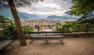
Vallesina/Versein, Mölten/Meltina, Bolzano/Bozen and environs
medium
Difficulté
1476 m
Gain d'altitude
43.5 Km
distance
1/3
Vallesina/Versein, Mölten/Meltina, Bolzano/Bozen and environs
medium
Difficulté
1476 m
Gain d'altitude
43.5 Km
distance
1/4
Malles/Mals, Mals/Malles, Vinschgau/Val Venosta
medium
Difficulté
1249 m
Gain d'altitude
26.4 Km
distance

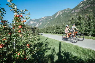
Cortaccia s.S.d.V./Kurtatsch, Kurtatsch an der Weinstraße/Cortaccia sulla Strada del Vino, Alto Adige Wine Road
easy
Difficulté
473 m
Gain d'altitude
40.0 Km
distance

1/2
Siusi/Seis, Kastelruth/Castelrotto, Dolomites Region Seiser Alm
medium
Difficulté
842 m
Gain d'altitude
10.0 Km
distance
1/3
Karthaus/Certosa, Naturns/Naturno, Meran/Merano and environs
medium
Difficulté
912 m
Gain d'altitude
9.2 Km
distance
1/4
Parcines/Partschins, Algund/Lagundo, Meran/Merano and environs
easy
Difficulté
765 m
Gain d'altitude
30.9 Km
distance
1/3
Cortaccia s.S.d.V./Kurtatsch, Kurtatsch an der Weinstraße/Cortaccia sulla Strada del Vino, Alto Adige Wine Road
easy
Difficulté
436 m
Gain d'altitude
62.7 Km
distance
1/4
Cauria/Gfrill, Salorno/Salurn, Alto Adige Wine Road
medium
Difficulté
1741 m
Gain d'altitude
121.4 Km
distance
Caldaro Paese/Kaltern Dorf, Kaltern an der Weinstraße/Caldaro sulla Strada del Vino, Alto Adige Wine Road
difficult
Difficulté
1936 m
Gain d'altitude
76.2 Km
distance
Nove Case/Neunhäusern, Rasen-Antholz/Rasun Anterselva, Dolomites Region Kronplatz/Plan de Corones
difficult
Difficulté
1656 m
Gain d'altitude
38.0 Km
distance
Resia/Reschen, Graun im Vinschgau/Curon Venosta, Vinschgau/Val Venosta
easy
Difficulté
30 m
Gain d'altitude
2.5 Km
distance
1/4
Marlengo/Marling, Mals/Malles, Vinschgau/Val Venosta
medium
Difficulté
892 m
Gain d'altitude
63.3 Km
distance
Novale/Ried - San Martino i.P./St. Martin i.P., St.Martin in Passeier/San Martino in Passiria, Meran/Merano and environs
medium
Difficulté
682 m
Gain d'altitude
17.5 Km
distance
Colle/Koll, Villnöss/Funes, Dolomites Region Lüsen Villnöss
medium
Difficulté
0 m
Gain d'altitude
673.0 m
distance
Lana di Sotto/Niederlana, Lana, Meran/Merano and environs
difficult
Difficulté
0 m
Gain d'altitude
113.3 Km
distance
Naturno/Naturns, Naturns/Naturno, Meran/Merano and environs
easy
Difficulté
1250 m
Gain d'altitude
23.9 Km
distance
1/4
Marlengo/Marling, Mals/Malles, Vinschgau/Val Venosta
easy
Difficulté
168 m
Gain d'altitude
60.8 Km
distance
Transacqua/Ennewasser, Martell/Martello, Vinschgau/Val Venosta
medium
Difficulté
764 m
Gain d'altitude
11.0 Km
distance
Montesole/Sonnenberg - Parcines/Partschins, Partschins/Parcines, Meran/Merano and environs
easy
Difficulté
821 m
Gain d'altitude
17.1 Km
distance
1/3
Ora/Auer, Auer/Ora, Alto Adige Wine Road
easy
Difficulté
0 m
Gain d'altitude
0.0 m
distance
1/3
Malles/Mals, Mals/Malles, Vinschgau/Val Venosta
medium
Difficulté
1051 m
Gain d'altitude
30 Km
distance
Nove Case/Neunhäusern, Rasen-Antholz/Rasun Anterselva, Dolomites Region Kronplatz/Plan de Corones
medium
Difficulté
778 m
Gain d'altitude
18.1 Km
distance
1/4
Tubre/Taufers i. M., Mals/Malles, Vinschgau/Val Venosta
easy
Difficulté
355 m
Gain d'altitude
22.5 Km
distance
Cortaccia s.S.d.V./Kurtatsch, Kurtatsch an der Weinstraße/Cortaccia sulla Strada del Vino, Alto Adige Wine Road
easy
Difficulté
545 m
Gain d'altitude
46.6 Km
distance
Maranza/Meransen, Bolzano/Bozen, Bolzano/Bozen and environs
medium
Difficulté
327 m
Gain d'altitude
103 Km
distance
Caminata di Tures/Kematen, Sand in Taufers/Campo Tures, Ahrntal/Valle Aurina
medium
Difficulté
92 m
Gain d'altitude
15.9 Km
distance
1/3
Scena/Schenna, Schenna/Scena, Meran/Merano and environs
easy
Difficulté
369 m
Gain d'altitude
19.5 Km
distance
1/3
Naturno/Naturns, Naturns/Naturno, Meran/Merano and environs
medium
Difficulté
455 m
Gain d'altitude
38.5 Km
distance
1/2
Kastelruth/Castelrotto, Sterzing/Vipiteno, Sterzing/Vipiteno and environs
medium
Difficulté
984 m
Gain d'altitude
65.3 Km
distance
Nove Case/Neunhäusern, Rasen-Antholz/Rasun Anterselva, Dolomites Region Kronplatz/Plan de Corones
medium
Difficulté
342 m
Gain d'altitude
25.3 Km
distance


