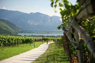
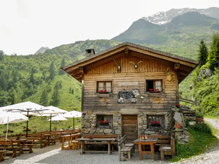
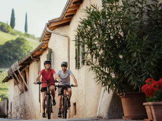
Skip to content
added to favourites
removed from favourites
Oops! Something went wrong. Try again
Your account is being created
Your account has been successfully created and you are now logged in
You are logged out.
Filter
Selected filters
    Level of difficulty
    Duration
    Distance in KM

    Bike tours

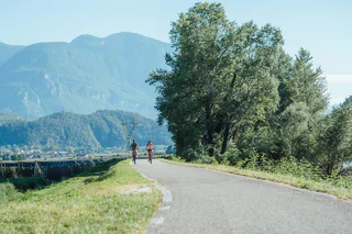
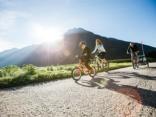
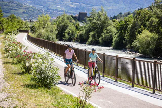
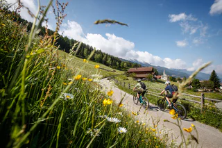
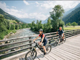
    Embark on thrilling bike tours in South Tyrol, pedaling through enchanting vineyards, picturesque valleys, and majestic mountains. Uncover breathtaking scenery, conquer challenging trails, and savor the region's rich culture and gastronomy. An unforgettable adventure for every cycling enthusiast!

    Results
    Cycling
    Cycle route | Lana to S. Leonardo in Passiria
    Lana, Meran/Merano and environs

    Begin in Andreas Hofer Strasse near Lana Tourist Information Office and ride to Tribusplatz square. There turn left into St. Agathaweg path and follow the road. At the end of St. Agathaweg turn right and cross the bridge over the MEBO expressway. Ride to the right to the Etschtal Valley cycle path and then right again towards Merano. At the dairy in Merano turn left into Schotterwerkstrasse and at the end turn left again into Katzensteinstrasse.

    At the crossroads turn left into Dante Alighieri Strasse and follow this until Brunnenplatz square in Obermais/Maia Alta. There cross the square and ride straight on into Virgilstrasse. Then turn left onto St. Georgenstrasse and at the end turn right. After approx. 100 m you will reach the Passeiertal Valley cycle path on your right-hand side. Follow this for 18 km.

    At the end of the cycle path follow the signposts for Merano center and ride along Sommerpromenade to Sissi Park. Here cross the road and pedal alongside the river Passer to Merano Thermal Baths. There turn right into Giosuè Carducci Strasse and over the bridge to Theater Platz square. Turn left into Carducci Strasse and follow this to the crossroads. Again turn left and follow the signs to the Bolzano cycle path. The return journey is via the same route from the Lana-Postal exit.

    Sights along the route: the Gardens of Trauttmansdorff Castle, Passeier Museum, Sissi Park in Merano, Merano Thermal Baths

    Difficulty: easy
    0 altitude up
    60.1 Km distance
    Cycling
    Bike route from Terlan to Lana
    Terlan/Terlano, The South Tyrolean Wine Road

    The route is easy to ride, there are no special height differences to be overcome. Three bike service areas invite you to have a rest: one stop at Vilpian shortly after the Etsch Bridge, a short drive further in Gargazon and one stop at Burgstall/Lana (via the "Old Railway Bridge").

    Attractions in Lana:

    • The Schnatterpeckaltar in the parish church of Niederlana
    • Museum of Fruit-Growing at Brandiser Waalweg No. 4 (near the golf course).
    Difficulty: easy
    93 altitude up
    30.9 Km distance
    Cycling
    The mystical Haderburg Castle in Salorno
    Auer/Ora, The South Tyrolean Wine Road

    The mystical Haderburg Castle in Salorno is majestically enthroned on a ledge and offers a breathtaking view over the whole valley.

    Difficulty: easy
    0 altitude up
    0.0 m distance
    Cycling
    Kaltern Bike Graveltour: To the Heilig lake
    Kaltern an der Weinstraße/Caldaro sulla Strada del Vino, The South Tyrolean Wine Road

    This is a wild and demanding gravel tour which will take you across the "Green Line" of the South Tyrolean forests and down to Lago Santo ("Lake Heilig") in Trentino. You'll proceed along winding forest trails and curving paths – requiring a good command of your gravel bike on earthy terrain.

    You'd better have an adventurous spirit if you want to undertake this tour. In the border area between South Tyrol and the province of Trentino, you'll be passing through seemingly endless forests radiating an enchanting quality. There are many reasons to undertake this tour: You'll love the unparalleled peace and quiet – in part on earthy trails where you can have some fun. And idyllic "Lago Santo" is certainly a worthwhile destination. You'll first proceed at a quick pace via Lake Caldaro and down into the Etsch / Adige Valley. You'll start your ascent on the valley's left flank near Auer / Ora. The trail along the former Fleims / Fiemme Valley railroad will afford you splendid views of the "South of South Tyrol." Once you've passed the last few hamlets, you'll be leaving civilization and ascending on forest roads to the Gfrill Saddle. After a short ascent, you'll arrive in the hamlet of Gfrill / Cauria, 1,000 meters above the Etsch Valley, the last small outpost of South Tyrol before you pass over the provincial border to Trentino. You'll enter into this wild forest and proceed along earthy trails on your way to Lake Heilig. But the adventure isn't over yet! First, there's an exciting descent where you'll come out in Salorno / Salurn, on the shores of the Etsch River. The Etsch Bicycle Trail is the quickest connection back to Lake Caldaro where you can perhaps take a refreshing dip and maybe enjoy a snack near Klughammer. The real end of this tour is only after you have accomplished the final 200 meters of altitude differential on your way to Kaltern / Caldaro. But you'll already have rest-stop options along the way – e.g., at the Albergo Lago Santo or in Salurn. Neumarkt / Egna is likewise worth a side-trip. The bicycle trail will lead you right to it.

    Variants: This tour can also be taken in the reverse order. However, when cycling from Salorno / Salurn up to Lake Heilig, you'll have to overcome slight ramps.

    Difficulty: easy
    1871 altitude up
    83.2 Km distance
    Cycling
    Wine & bike: The Wine Road
    Bolzano/Bozen, Bolzano/Bozen and environs
    The circular bike tour leads through some of the most famous and beautiful historical wine villages along the South Tyrolean Wine Road, Cornaiano/Girlan, Appiano/Eppan, and Caldaro/Kaltern, well-known for their Pinot Blanc wine.

    From Bolzano follow the bike trail that leads to Cornaiano, a historical wine village featuring underground cellars that take up more space than the village itself. The next stage is San Michele/St. Michael, the actual centre of the Appiano castle region. A visit to the wineries in this outstanding wine region is really worthwhile. The wine route now leads back to Caldaro by the lake, famous not only for the wine named after the Kalterer See, but also because it is one of the most well-known wine villages in the province. The route then leads to the village Ora/Auer and from here returns to Bolzano following the Adige/Etsch river.
    Difficulty: medium
    436 altitude up
    49.2 Km distance
    Cycling
    Kaltern Bike Graveltour: "Gfriller Sattel"
    Kaltern an der Weinstraße/Caldaro sulla Strada del Vino, The South Tyrolean Wine Road

    This is a challenging gravel tour in which you will proceed from the shore of the Etsch River via a demanding ascent to this hidden pass. In the Etsch / Adige Valley, it will take you to Salorno / Salurn, on the border to Trentino and then disappears in the quiet forest behind the cliffs which sharply demarcate the Etsch / Adige Valley on the eastern side.

    The start will help you limber up and warm your muscles. From Kaltern / Caldaro, you'll roll down at a fast pace to Lake Caldaro. From the southern shore of the lake, you'll quickly reach the Etsch Valley Bicycle Trail. Here, you will follow the river another 10 km – with a tailwind, if you're lucky – and soon reach Salorno / Salurn, the southernmost settlement in South Tyrol. But that isn't entirely true – because just before you come to it, there's a forest road representing a short-cut to the road up to Gfrill / Cauria, a peaceful hamlet 1,000 meters above the valley. That is the decisive ascent of this tour – because you'll have to master another 200 meters of altitude differential on forest trails to the saddle – with an average grade of 10%. This is then followed by a descent of 400 meters on the other side on gravel trails in the forest as you approach Gschnon / Casignano. This is the perfect place to take a short side-trip (one kilometer in each direction) to the "Kanzel," an extraordinary lookout point high above the Etsch Valley. A street leads from Gschnon to Mühlen and into the valley through which the Truden Brook runs steeply down into the Etsch / Adige Valley. You'll follow it uphill till you get to Truden / Trodena and gain another 300 meters of altitude differential along the little valley road. The descent from Truden into the Etsch / Adige Valley represents the highpoint of this tour, with regards to beautiful landscape. The gravel trail along the former Fleims / Fiemme Valley railroad will take you down to Montan / Montagna. ATTENTION! The entrance to the tunnels can be a little daunting – built-in motion sensors will first have to detect your presence before they switch on the lights. After you've exited the final tunnel, the landscape will open up, and you'll be treated to a sublime view of the Etsch / Adige Valley – the most-spectacular of which is on the viaduct near Pinzon / Pinzano, a looped bridge which the engineers used to elegantly smooth out the necessary hairpin curve of the railroad in the somewhat steeper area of the slope. Then you'll be treated to the Castelfeder biotope, an ancient cult site which is certain to catch your eye against the surrounding landscape. Extravagant geological formations and enormous boulders left behind by receding glaciers are scattered about at various elevations. The wild, romantic hilly landscape has lost none of its magical appeal. Castelfeder is the subject of numerous legends and stories. The so-called "Kuchelen" on the highest level are the remains of a ring wall dating back to the Early Middle Ages. This is an ideal place to pause for a breather and enjoy the scenery. Or to prepare for the next segment. That's because the trail from the Etsch / Adige Valley, Lake Caldaro, and uphill to the center of Kaltern represents another 200 meters of altitude differential to be managed.

    Variants: If you'd like to enjoy some sightseeing in Salorno / Salurn, you can also take the ascent to Gfrill / Cauria from the center of Salurn. However, that entails more time on the streets. If you'd like to take a short-cut, proceed from Mühlen and follow the Truden Brook downhill until you return to the main trail just before you pass the small hamlet of Glen prior to the viaduct.

    Difficulty: easy
    1868 altitude up
    80.0 Km distance
    Cycling
    Tour to the Garda Lake
    The South Tyrolean Wine Road

    This tour leads you to the breathtaking GardaLake with its Mediterranean flair and pictorial villages.

    Difficulty: medium
    0 altitude up
    0.0 m distance
    Cycling
    Bike tour in Terlan
    Terlan/Terlano, The South Tyrolean Wine Road

    This route crosses four villages of the Val d'Adige by orchards, vineyards, along the forest and also provides some viewpoints. The route is easy to ride, since no large height differences have to be overcome. There are several places of interest which invite you to linger. The route leads not only past designated bike paths, but also to non-busy routes. Very easy to ride with the bike.

    Difficulty: easy
    121 altitude up
    12.3 Km distance
    Cycling
    Bolzano's bike routes
    Bolzano/Bozen, Bolzano/Bozen and environs

    A bike ride past the main sights of the town and its surroundings

    The beginning of our Bolzano bike-tour is the Talvera/Talfer bridge. We follow the cycle-lane along the left-hand bank of the river, going northwards, passing idyllic Castle Mareccio/Maretsch, nestling in the vineyards, up to Sant'Antonio/St. Anton, where the valley begins to narrow, and on to the fairy-tale Castle Roncolo/Runkelstein with its amazing frescoes. After visiting the castle (leave your bike in the bike-park below, before walking up the short but steep path to the castle), you make your way back to the Talfer bridge. At the Piazza Vittoria/Siegesplatz you could visit the new museum-display entitled "BZ 18-45" in the crypt of the Victory Monument. Then we cycle down the Corso Libertá/Freiheitsstrasse to the square of Gries, formerly a village-municipality in its own right and an internationally-renowned spa. The square is dominated by the massive baroque parish church and Benedictine monastery. Nearby is the old parish church of Gries with its romantic cemetery outside and a gem of Gothic wood-carving inside, the beautiful altar by Michael Pacher. From Gries we take the Vittorio Veneto street westwards. For the first 100 metres you will really need to pay attention to the traffic until you hit the cycle lane again. You then pass farms and vineyards before you come to the hospital.  Here the cycle lane forks and you head for the Via Druso/Drususstraße. At the big roundabout follow the signs for Appiano/Eppan as far as the bridge, then take the cycle lane to Castle Firmiano/Sigmundskron and the Messner Mountain Museum. The way back follows the bank of the Isarco/Eisack river, passing below several bridges. After the swimming pool complex we turn left just before the yellow iron bridge, now following the Talvera river until we come opposite the futuristic glass cube of the Museion modern art gallery. We are now back in the town centre, but we have to watch out: the Via Museo/Museumstraße, the Piazza Erbe/Obstplatz and the Piazza Walther Platz are pedestrianized and closed to cyclists, so that means pushing the bike. If you still have got some energy left, you could visit the Ötzi Museum, the Civic museum or the Natural History Museum.

    Difficulty: easy
    153 altitude up
    18.8 Km distance
    Cycling
    Drava Cycle Path (Drau-Radweg): Innichen/San Candido - Lienz (AUT)
    Innichen/San Candido, Dolomites Region 3 Zinnen

    This cycling tour takes you along a marked cycle trail from San Candido (or from Villabassa/Niederdorf or Dobbiaco/Toblach) via Versciaco/Vierschach and Prato Drava/Winnebach along the Drava (Drau) river to Lienz and is suitable for all types of bikes.

    Characteristics: The route goes from San Candido in Italy to Lienz in East Tirol. This part of the Drava cycle trail was the first to be developed and is currently the best maintained section. You can also start in Villabassa or Dobbiaco, which would make the tour longer accordingly. The section from Dobbiaco to Sillian is downhill. The cycle trail is almost always away from the road on the other side of the river and, because of its width and gradient, is also suitable for families with young children. Along the way there are several bus stops so that sections can be shortened if necessary. The route is well signposted and asphalted throughout. There are many opportunities for rest and refreshment along the way.

    Starting points: Villabassa/Niederdorf (52,5 km), Dobbiaco/Toblach (47,8 km), San Candido/Innichen (44,8 km)

    This tour is also suitable for e-bikes.

    flyer & train information

    Difficulty: easy
    0 altitude up
    44.8 Km distance
    Cycling
    Bassa Atesina/Unterland Tour
    Auer/Ora, The South Tyrolean Wine Road

    Visit the Bassa Atesina and go in for a beautiful bike tour alomg the Südtiroler Weinstraße/Strada del Vino. The pictorial arbours of Egna, the contemplative Village Cortaccia and the romantic historical center of Termeno are waiting for you!

    Difficulty: easy
    273 altitude up
    25.3 Km distance
    Cycling
    Adige cycling path along the Via Claudia Augusta from Naturno to Nalles
    Tisens/Tesimo, Meran/Merano and environs

    The Adige cycling path along the Via Claudia Augusta is a cultural experience through gardens and architecture. The cycling path leads you through the beautiful landscapes of the Etschtal Valley from the Vinschgau Valley to Merano/Meran and to the south to Bolzano/Bozen and Caldaro/Kaltern. Here is the description of the tour from Stava/Staben near Naturno/Naturns to Nalles/Nals, which leads you to Merano and further south. Without any big efforts you can explore the wide valley. The tour is ideal for families and bikers who want to take it slow.

    https://maps.merano-suedtirol.it/en/etschradroute

    Difficulty: easy
    279 altitude up
    34 Km distance
    Cycling
    E-Bike tour Ratsberg/Monte Rota
    Toblach/Dobbiaco, Dolomites Region 3 Zinnen

    The moderately difficult e-bike tour runs mainly on asphalt roads, but also on a forest path. The tour offers a wonderful view of the Höhlensteintal/Val di Landro  valley and the Toblach/Dobbiaco lake.

    Charging stations:
    Dobbiaco/Toblach center

    Difficulty: medium
    436 altitude up
    12.2 Km distance
    Cycling
    E-Bike tour Toblach/Dobbiaco - Cortina
    Toblach/Dobbiaco, Dolomites Region 3 Zinnen

    The scenery is dominated by the panorama of the Dolomites UNESCO World Heritage. The route follows the old railway from Toblach/Dobbiaco to Cortina d´Ampezzo, from the Hochpustertal/Alta Pusteria valley across the Höhlensteintal/Val di Landro valley, past lakes and the View of the Three Peaks.  

    From Cortina back to Toblach there are buses with bike trailers operated by the Cortina Express bus company (only in season).

    Charging stations:
    Dobbiaco/Toblach center
    Hotel Tre Cime/Drei Zinnen
    Hotel Union
    Cheese Dairy Three Peaks

    Difficulty: medium
    563 altitude up
    30.7 Km distance
    Cycling
    E-Bike tour Silvestertal/Valle San Silvestro valley
    Toblach/Dobbiaco, Dolomites Region 3 Zinnen

    The mountainbike roundtour with the Silvesteralm/Malga San Silvestro hut and the Lachwiesenhütte/Rifugio Lachwiesen hut, which invite you to stop for a break, runs mainly on forest paths in the middle of the forest. This tour does not have any difficult parts.

    Charging stations:
    Dobbiaco/Toblach center

    Charging possibility:
    Malga San Silvestro/Silvesteralm hut


    Difficulty: easy
    674 altitude up
    21.4 Km distance
    Cycling
    Kaltern Bike Graveltour: Regglberg "Almrunde"
    Kaltern an der Weinstraße/Caldaro sulla Strada del Vino, The South Tyrolean Wine Road

    The Regglberg is a high-altitude plateau rising above the eastern shores of the Etsch / Adige River. If you choose to ascend from Leifers / Laives to Deutschnofen / Nova Ponente, you'll land in a landscape of alpine meadows. Here you'll find plenty of rest-stop options – too many, in fact, since you couldn't possibly stop for a break in every inn and cafe situated along this challenging and long tour.

    This tour is challenging, but allows you to explore the east of the Etsch / Adige Valley, on the fringe of the foot of the Dolomites. The meadow landscape at the Regglberg between Deutschnofen and Aldein / Aldino resembles a verdant carpet stretching out in front of the impressive Latemar – from the perspective of Kaltern, the nearest outpost of the Dolomites, this most-prominent peak looms 2,842 meters above sea-level. But to approach it, you'll have to constantly pedal. The first milestone of your journey is the Mitterberg / Monte di Mezzo, accessible via the little Pass Road and the Kreither Saddle and then into the Etsch / Adige Valley. After a couple of relatively level kilometers, you'll reach Leifers / Laives, where the Branten Valley indicate the continued upward direction. At the upper end of the Branten Valley, you'll find the town of Deutschnofen / Nova Ponente perched on a high-altitude plateau. There is a path in the valley basin for your ascent, but the winding trails on the north flank of the valley offer more scenic beauty and are just as quick – besides giving you more panoramic views towards Deutschnofen. You will now proceed upwards into the rolling meadow landscape. You've mastered the steep uphill grade; now, it's a constant up and down. This route offers beauty and variety, and every couple of kilometers, you can take a rest-stop at one of the many charming inns and cafes along the way: the Laabalm, the Neuhütt-Alm, the Schmiederalm, or the Schönrast-Alm. In view of this wealth of options, you might be tempted to spend too much time here – but don't forget: The return leg is still ahead of you! The trail will first take you down into the Etsch Valley. But because the direct way from the Regglberg into the valley is possible only via very steep trails that are best traversed on foot, you'll have to instead take a slight diversion and follow the trail along the former Fleims / Fiemme Valley railroad, which displays a pleasant downhill grade at Montan / Montagna. And you'll be treated to spectacular scenery along the way: First, there's the unobstructed view of the valley, then the rolling terrain of the Castelfeder biotope with its mystical medieval cult site. Once you've arrived in Auer / Ora, you can traverse the Etsch River and quickly reach Lake Caldaro. On warm summer days, you could now take a pleasant dip at Klughammer. After a refreshing dip, you'll be ready to attack the final 200 meters of altitude differential from the lake up to Kaltern / Caldaro.

    Difficulty: easy
    1936 altitude up
    76.2 Km distance
    Cycling
    Bike route Val Casies - Gsieser Tal
    Welsberg-Taisten/Monguelfo-Tesido

    This cycle route starts in the heart of the village of Monguelfo and heads into the valley along the banks of the Gsieser Bach stream. Stay on the old Gsieser Tal valley road until you come to the hamlet of Oberplanken, where you cross the stream. In the hamlet of Preindl, you should follow the main road for a brief period – but you can return to the bank of the stream once you come to the small Church of Mary of the Visitation. The tour then continues on to San Martino, after which you head uphill to the Talschlusshütte mountain hut in Santa Maddalena. The return journey follows the same route in reverse.

    Difficulty: medium
    425 altitude up
    18.3 Km distance
    Cycling
    Passeiertal Valley Bike Path
    St.Leonhard in Passeier/San Leonardo in Passiria, Meran/Merano and environs

    The 20-km bike path along the Passer river promises unforgettable moments with your family.

    Difficulty: easy
    17 altitude up
    20 Km distance
    Cycling
    Cycle route | From Lana to Lake Kalterersee
    Lana, Meran/Merano and environs

    Begin in Andreas Hofer Street near Lana tourism association and ride to Tribusplatz square. There turn right into Treibgasse and then left at the crossroads into Zollstrasse. Follow the signposts to Bolzano (left). Cross the MEBO highway and the river Etsch and ride along the Bolzano-Merano cycle path towards Bolzano.

    In Ponte d’Adige follow the signposts to Appiano. Passing Sigmundskron Castle, turn right onto the Bolzano-Appiano cycle path. In San Michele/Appiano follow the signposts to Caldaro. At the end of the cycle path in Caldaro (near the winery) ride along the main road to the junction of Klughammer/Ora cycle path. The route takes you through vineyards to Lake Kalterersee.

    At the end of an alley turn right and ride along the Kalterer Moos road to the roundabout. Take the third exit. Cross the highway and the river Etsch and ride along the Bolzano-Trento cycle path for approx. 16 km to Bolzano. There, at the turnoff for Überetsch/Oltradige take the Bolzano-Merano cycle path and return to the starting point on this path.

    Sights along the route: Lana-Postal electric locomotive, Caldaro Wine Museum, MMM Firmian in Sigmundskron, Lake Kalterersee habitat.

    Difficulty: medium
    0 altitude up
    81.8 Km distance
    Cycling
    Cycle route | Lana to Martello
    Lana, Meran/Merano and environs

    Begin at Lana Tourist Information Office in Andreas Hofer Strasse and ride to Tribusplatz square. There turn left into St. Agathaweg path and follow the road. At the end of St. Agathaweg turn right and cross the bridge over the MEBO highway. Ride to the right to the Etschtal Valley cycle path and then right again towards Merano. In Sinigo turn left (signposts to the Vinschgau Valley) and follow the white/green signage.

    After passing the racecourse in Merano turn right. Continue to follow the signs for Vinschgau (Note: within Merano, the signage is green). Ride along the right-hand bank of the Etsch to Lagundo. The climb to Tel begins on Schwimmbadweg path. At the start and end of the climb there are places to stop for a rest and a drink of water. Continue to ride to Tel and cross the main road there. Then turn right and follow the cycle path as far as Naturno. Here cross the river, ride approx. 3 km to Stava and cross back over the river. At the junction for the cycle path to Passo Resia pass turn right and follow the trail until you have crossed over the river.

    Then turn left into the cycle path and ride to Coldrano past Lake Goldrain. At the end of the cycle path turn left to Martello. Follow the main road until you eventually reach the Church of Maria in der Schmelz. The ride can be extended with a detour to the Zufrittsee reservoir, which is approx. 8 km away (1,850 m - ramp with 20% incline).

    Sights along the route: dam on the Tel, Prokulus Church in Naturno, Culturamartell Stilfserjoch National Park.

    Difficulty: difficult
    0 altitude up
    113.3 Km distance
    Cycling
    Radroute | Von Lana zum Naturbad Gargazon
    Lana, Meran/Merano and environs

    Begin in Andreas Hofer Strasse near Lana tourism association and ride to Tribusplatz square. Here turn right into Treibgasse and left at the crossroads into Zollstrasse. Follow the signs for Bolzano (left). Cross the MEBO highway and the river Etsch and ride along the Bolzano-Merano cycle path towards Bolzano.

    In Gargazon turn left and access the natural swimming pool via an underpass. Return to the starting point via the same route. Gargazzone natural swimming pool offers a natural water landscape and uses absolutely no chemical additives for cleaning the water. The secret of the natural, clean water is in its plant life.

    Opening times natural bath Gargazon: middle of May to early September, daily from 10 a.m. to 7 p.m. Evening opening: Tuesdays and Fridays until 8 p.m. (middle of June to mid-August)

    Sights along the route: Lana-Postal electric locomotive

    Difficulty: easy
    0 altitude up
    16.2 Km distance
    Cycling
    Cycling tour to the Lake Kaltern
    Terlan/Terlano, The South Tyrolean Wine Road
    We ride on the Etsch cycle path from Terlan in the direction of Bozen to the Sigmundskron train station. Here we take the main road, cross the Etsch bridge on the right and then drive towards Girlan. After a short ascent, we come back to the bike path, which leads in a moderate incline and with a wonderful view of the Adige Valley to the village of St. Michael / Eppan. Here we always stay on the bike path and continue to the village of Kaltern, where we come to the “New Cellar”. There we have to cycle back a short distance and then come right downhill through the orchards into the Lavason valley. We ride downwards and enjoy the wonderful view of Lake Kaltern. At the crossroad to Kaltern we stay left towards Klughammer. Here the lake is on our right. We continue to Gmund and keep left, past some houses, pass under the motorway, onto a bridge and immediately turn left onto the cycle path towards Bozen. Along the Etsch river it goes to Bozen Süd, where you turn left towards Sigmundskron and Terlan.
    Difficulty: easy
    355 altitude up
    52.6 Km distance
    Cycling
    Cycle route | Lana to Meltina via Terlano
    Lana, Meran/Merano and environs

    Begin in Andreas Hofer Strasse near Lana tourism association and ride to Tribusplatz square. Here turn right into Treibgasse and then left at the crossroads into Zollstrasse. Follow the signs for Bolzano (left). Cross the MEBO highway and the river Etsch and ride along the Bolzano-Merano cycle path towards Bolzano.

    At the end of the cycle path in Terlano ride left over the rail crossing and then continue right into the center of Terlano. Go straight ahead at the roundabout and turn left near the Haus des Apfels building after Meltina. Follow this twisting road to the parishes of Verschneid and Versein before reaching Meltina.

    There, after a steep sloping section turn left into Schlaneider Strasse as far as the crossroads to Paradeis. Turn left here and continue into Aschler Bachstrasse road, which opens out into Vöraner Strasse. Follow this road to Avelengo. Before entering the first tunnel ensure that you put on your reflective vest/strips! The descent towards Merano begins here. The route negotiates several reversements to Maia Alta; at the roundabout continue to Sinigo passing the Gardens of Trauttmansdorff Castle. In Sinigo take the cycle path to Bolzano; leave the path in Postal on the bridge and ride back to the starting point.

    Note: you will pass through a number of tunnels. Ensure that you have lighting for your bicycle.

    Difficulty: medium
    0 altitude up
    68.5 Km distance
    Cycling
    Cycle route | On the tracks of the railway
    Lana, Meran/Merano and environs

    Begin at the Lana Tourist Information Office in Andreas Hofer Strasse and ride to Tribusplatz square. There turn left to Falschauer bridge. Follow the signposts to Merano (right) and cross the bridge over the MEBO expressway. Drive on the transregional cycle path towards Merano. In Sinigo follow the signposts for the Vinschgau Valley. After passing the racecourse in Merano turn right. Continue to follow the signs for Vinschgau. (Note: within Merano, the signage is green).

    Ride along the right hand bank of the river Etsch to Lagundo. The climb to Tel begins at the swimming baths. At the start and end of the climb there are places to stop for a rest and a drink of water. At the end of the climb you will also be rewarded by a wonderful view. Continue to ride to Tel and cross the main road there, turn right and follow the cycle path to Naturno past the public playground.

    Here cross the river and ride along the left bank after approx. 2 km to the Erlebnisbahnhof (adventure railway station) which is reached via the underpass. (Note: the adventure station is only open on Sundays from 2-6 pm from May to the end of October). The return journey is along the same route as far as Sinigo; from there continue towards Bolzano. Just after the exit for Lana, there is a restored locomotive to the right of the rest point that is well worth seeing. Your ride can be concluded with a visit to Lana open air pool.

    Sights along the route: dam on the Tel, Prokulus Church in Naturno, Rablà railway museum.

    Difficulty: medium
    0 altitude up
    60.1 Km distance
    Cycling
    Kaltern Bike Graveltour: Tour of Caldaro
    Kaltern an der Weinstraße/Caldaro sulla Strada del Vino, The South Tyrolean Wine Road
    If you start cycling in Kaltern, you will first find yourself surrounded by vines. Soon, however, the paths disappear into forests where you can lose yourself. This tour can only explore a few kilometres of the huge network of paths, but as a selection of the best paths it does justice to the claim of getting to know the area.

    It first leads into the forest on the western flank of the Adige Valley between the sports centre and the small hamlet of Altenburg with one of the most beautiful viewpoints over Lake Kaltern. On the other side, between Kaltern and Etsch, rises the Mitterberg. From the Adige valley, rugged walls rise 400 metres steeply. On the Kalterer side, the wooded terrain slopes gently. Over there is the next destination of the tour, the large stone valley. On the slopes of the Mitterberg you now stay in the forest and pass the Montiggler Lakes. Here you can dangle your feet in the water or go swimming. The Montiggl forest offers an endless network of paths that lead via the village of Montiggl to the cosy wine village of Girlan. Now the vines line the path again when it goes from Girlan back to Kaltern.

    Variants: You can also skip the detour to Altenburg and just do the short loop via the Große Steintal and Montiggl to Girlan. If you feel like it, you can also include a detour to Lake Kaltern in the loop.
    Difficulty: easy
    840 altitude up
    35.0 Km distance
    Cycling
    Pustertal Valley Cycle Trail: Innichen/San Candido - Bruneck/Brunico
    Innichen/San Candido, Dolomites Region 3 Zinnen

    A very varied cycling trip through the wonderful scenery of the Pustertal valley.

    Characteristics: The bike tour takes you sometimes on asphalt tracks and sometimes on well-maintained gravel tracks across meadows and through woods on the left of the main Pustertal valley road to Brunico/Bruneck. You start at 1,175 m in San Candido/Innichen and end up at 800 m in Brunico. The difference in altitude of only 400 m is deceptive; there are some sections that are really tiring. However, most of the route is flat, and from Valdaora/Olang it is almost all downhill. Conveniently, you can put your bike on the train to return. For less experienced cyclists or for families with children, there is the option of travelling back by train from any of the villages on the way.

    Starting points: San Candido/Innichen (35 km), Dobbiaco/Toblach (30 km), Villabassa/Niederdorf (27,5 km)

    This tour is also suitable for e-bikes.

    flyer & train information

    Difficulty: medium
    0 altitude up
    35 Km distance
    Cycling
    From Ora to Trento
    The South Tyrolean Wine Road

    This tour leads you through the Adige cycle path to the historic city of Trento.

    Difficulty: easy
    0 altitude up
    0.0 m distance
    Cycling
    Monte S. Pietro link Trail
    Deutschnofen/Nova Ponente, Dolomites Region Eggental
    This easy bike link tour conects the village of Monte S. Pietro with the famous Pilgrimage site of
    Madonna di Pietralba. The tour delights everyone, as it runs mostly on paved roads and offers a fantastic view of the neighbouring Dolomite mountains such as Rosengarten/Catinaccio, Schlern/Sciliar and Latemar.
    Difficulty: easy
    139 altitude up
    2.3 Km distance
    1 2 3 4 5 6 7 8 9 10 11
      image
      Summer
      Uphill Seespitz
      Meran and environs
      Starting point: Töll Etschbrücke (525 m) End point: Gasthaus …
      44 km total slope
      7 lifts
      Highest point: 2,505 m