Südtirol Guide App Logo
Přeskočit na obsah

přidáno k oblíbeným

odebráno z oblíbených

Jejda! Došlo k problému, zkuste to prosím znovu

Vytváří se váš účet

Váš účet byl úspěšně vytvořen a nyní jste přihlášeni

Jste úspěšně přihlášeni!

Váš účet byl úspěšně vytvořen, ale nepodařilo se nám vás automaticky přihlásit

Jste odhlášeni

Filtr
Vybrané filtry
    Úroveň obtížnosti
    Doba trvání
    Vzdálenost v km

    Dovolená v Sterzing/Vipiteno a okolí

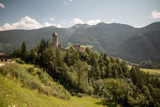
    Objevte jedinečný charakter jihotyrolského údolí Wipptal s malebným Sterzingem/Vipitenem, nejsevernějším městem Jižního Tyrolska. Boční údolí Alp nabízejí impozantní horské vrcholy a vášnivou sportovní kulturu. Cestou poznávejte a setkávejte se s krásnými hrady.

    Výsledky
    Summer
    Excursion to the Sternhütte at Rosskopf
    Ratschings/Racines, Sterzing/Vipiteno and environs

    Starting point: mountain station Rosskopf Monte Cavallo (1.860m)
    The cable car (valley station near the north park in Vipiteno) takes you to the mountain of Vipiteno. Leave the mountain station and follow on your right the marked trails: “Kastellacke”, “Flaner Jöchl” or “Vallminger Almen”. After approx. 15 minutes of walking time you finally reach the mountain hut Sternhütte above the mountain station.
    Alternative: by foot to the Rosskopf Monte Cavallo: starting point is the valley station of the Rosskopf Monte Cavallo cable car. Follow path no. 19 or no. 23 through a shady forest and over serpentines to a forest path. Continue to the mountain station. From there follow the trails “Kastellacke”, “Flaner Jöchl” or “Vallminger Almen” until you reach the mountain hut Sternhütte.
    Tip: children’s playground and sunbathing area, on Sundays spear ribs

    Obtížnost: nízká
    72 m nadmořská výška
    0h:16 min doba trvání
    Summer
    To the Rofis Boden
    Freienfeld/Campo di Trens, Sterzing/Vipiteno and environs

    Easy family hiking tour from Stilves to the Rofis Boden wood play ground. Start in Stilves and along the road in direction Niederried/Novale Bassa. Soon after leaving the village along the trail 17 on the right side upwards to the Rofis Boden. Along the forestal road you will arrive to the Rofis Boden also with a stroller.

    Lunch possibility: Walcher Bakery, Hotel Wieser

    Obtížnost: nízká
    138 m nadmořská výška
    1h:45 min doba trvání
    Mountaineering
    Alpine Path Zirog/Zirago
    Brenner/Brennero, Sterzing/Vipiteno and environs

    From Gossensass/Colle Isarco trail nr. 22 to the mountain hut Hühnerspiel/Cima Gallina and then on trail nr. 11 to the pastures of Zirog/Zirago. Descent to the village Brennerbad/Terme di Brennero and back to Gossensass/Colle Isarco with the bus.

    Obtížnost: vysoká
    1144 m nadmořská výška
    6h:30 min doba trvání
    Mountaineering
    To the Gliederscharte
    Vintl/Vandoies, Sterzing/Vipiteno and environs

    By the 3rd turn following the trail 1 to the mountain huts and furtheron on the right trail (mark 8) along the stream through the valley. Passing on the bridge the stream and following always trail 8, on the steep and stoney walk upwards to the Gliederscharte joke (2635m) with a wonderful view on the Hochfeiler summit.

    Obtížnost: střední
    1094 m nadmořská výška
    4h:30 min doba trvání
    Mountaineering
    To the Kraxentrager summit
    Pfitsch/Val di Vizze, Sterzing/Vipiteno and environs

    Start by the parking lot at the 4th turn on the forrestal road to the Pfitscherjoch joke. On the trail 4A over the Grieplalm pasture (no service) to the Landshuter Höhenweg trail (mark 3) and furtheron to the Europahütte mountain hut. By the hut following trail 3A along the Italian and Austrain border crest to the Kraxentrager summit (2999m). The last part is exposed, but fixe with a steel rope. Lunch possibility: Europahütte mountain hut

    Obtížnost: vysoká
    1662 m nadmořská výška
    7h:00 min doba trvání
    Mountaineering
    Wetterspitze from Maiern/Masseria | Ridnauntal/Val Ridanna
    Ratschings/Racines, Sterzing/Vipiteno and environs

    In Maiern/Masseria, at the end of the Ridnauntal valley, starts the Path no. 27, first through the mountain  forest and then up to meadows. In about 1 ½ hours you reach the mountain pasture Prischeralm (2160m). From there rise up in not steep serpentines for about 1 hour to the pass Maurerjoch (2511m). From the pass continue over the western ridge on a climb to the summit for about ½ hour. Surefootedness and no fear of heights necessary!

    Obtížnost: vysoká
    1349 m nadmořská výška
    5h:00 min doba trvání
    Summer
    To the mountain hut Hühnerspiel/Gallina
    Brenner/Brennero, Sterzing/Vipiteno and environs

    The starting point is the Gossensass parking lot in the town center at Ibsen Square (1,098 m). From Ibsen Square, the trail leads north to the Raiffeisen Bank, where you cross the pedestrian crossing to reach the "Alte Postgasse" Alley. Then, head east, climbing uphill, passing the Aparthotel Pichler on the left. At the intersection, you will find the trail signs, and from there, Trail No. 22 leads up to the mountain hut Hühnerspielhütte (1,868 m).

    Variant:
    From Sterzing, drive on the state road towards Brenner. After about 4 km, you will reach the village of Gossensass. Continue on the road for another 3 km until you reach a sharp S-curve (first a right turn, then a left turn). In the left curve, you will find an exit for the highway on the right, and right next to it, a narrow asphalted road. Follow this road for about 800 m to reach the DAX parking lot. From there, continue on foot along a forest road to the hut.

    Obtížnost: střední
    797 m nadmořská výška
    3h:15 min doba trvání
    Mountaineering
    To the Günther Messner bivouac
    Vintl/Vandoies, Sterzing/Vipiteno and environs

    By the 3rd turn on the road to the Pfitsch joke following trail 7 on the left valley side, through alpine pastures to a scree slope and upwards the moraine to the bivouac (2510m) in front of the big northern walls of the Hochferner and the Griesverner.

    Obtížnost: vysoká
    851 m nadmořská výška
    4h:00 min doba trvání
    Summer
    To the Drosberg pastures
    Pfitsch/Val di Vizze, Sterzing/Vipiteno and environs

    Start by the Fußendras hamlet along trail 17 through the Droßberg valley on the steady ascending trail to the Drosberg mountain hut (1933m, no service).

    Obtížnost: nízká
    602 m nadmořská výška
    2h:04 min doba trvání
    Summer
    To the Edelweiß mountain hut
    Brenner/Brennero, Sterzing/Vipiteno and environs

    Going left from the Ladurns mountain station a farm trail climbs gently over the so-called Mahder to the Edelweiss Hut.

    Obtížnost: nízká
    246 m nadmořská výška
    1h:38 min doba trvání
    Summer
    To the pasture Furtalm/Malga Furt
    Brenner/Brennero, Sterzing/Vipiteno and environs

    Starting point: park area Stein/Sasso (1.350m) or park area "Hölle/All'inferno" (1.450m)
    Version 1: starting from Stein/Sasso in Pflersch/Fleres walking towards the valley on the sunny side over the easily accessible pasture path in direction to the mountain pasture Furtalm. Version 2: over the forest path, underneath the Steinhöfe turn left and continue until you reach the mountain pasture Furtalm/Malga Furt. Version 3: from the gate following the signpost “Pflerscher Hölle” on your right and from there you reach the destination over a pasture path after approx. 45 minutes. Tip: special location at the valley basin, hiking tour for families, handmade products.

    The starting point of this beautiful hike is the parking lot in Stein, Innerpflersch at 1,350 m. You can choose from three different routes:

    • Option 1: Hike along the sunny side of the valley via the Waterfall Trail No. 6 towards Furtalm, reaching it in about 1.5 hours.
    • Option 2: For a shorter route, follow the wide forest path 6B, below the Steinhöfe, where you turn left after about an hour to reach Furtalm.
    • Option 3: From the barrier, take the path on the right marked to the "Pflerscher Hölle." From here, you’ll reach the Furtalm in about 45 minutes via the alptrail.

    The Furtalm is located in a quaint basin, offering a perfect spot for a break. Enjoy homemade products, and it's an excellent family-friendly hike. For an even more immersive nature experience, combine the hike with a visit to the "Hölle" Waterfall and its new viewing platform.

    Obtížnost: nízká
    222 m nadmořská výška
    1h:04 min doba trvání
    Mountaineering
    To the Mountain hut Tribulaun near the Lake Sandessee
    Brenner/Brennero, Sterzing/Vipiteno and environs

    From the parking place Stein/Sasso in the Pflersch/Fleres valley on the trail nr. 8 to the mountain hut Tribulaunhütte. Descend on the same trail.

    Obtížnost: vysoká
    1000 m nadmořská výška
    4h:46 min doba trvání
    Summer
    To the Redwitzplatz/Radura Redwitz
    Brenner/Brennero, Sterzing/Vipiteno and environs

    For those looking to explore a new, refreshing path, a visit to Redwitzplatz in Gossensass is perfect. The trail begins by crossing the river of Pflerscher at the sports field, then turning right into the wonderful river promenade. Right at the start of this promenade, a small path to the left leads you to Redwitzplatz, where the healing iron spring is located – a true gem for nature and health enthusiasts. From here, various routes open up, leading to Gottschalkweg trail, Vallmingalm hut, or back to the river promenade.

    To get there, you can park at the Gossensass train station parking lot, just 10 minutes away. From there, the path takes you through the pedestrian underpass, then turning right into the valley and left at the second side street, heading towards the forest. The football field is visible from a distance, serving as a landmark.

    A special highlight at Redwitzplatz is the new barefoot trail, allowing you to connect with the earth naturally – a refreshing and relaxing experience. The area is perfect for relaxation or enjoying a picnic surrounded by nature. If you’re looking for a varied outing in a beautiful setting, this is the place for you.

    Obtížnost: nízká
    67 m nadmořská výška
    0h:25 min doba trvání
    Summer
    To the Riedbergalm
    Pfitsch/Val di Vizze, Sterzing/Vipiteno and environs

    Starting point: park area a few meters after the Braunhof (1.350m) in Schmuders near Prati.
    From the inn Braunhof near Schmuders follow the marked trail no. 3 on good forest paths upward the mountain pasture Prantneralm. From there a forest path leads to the mountain pasture Riedbergalm.
    Tip: handmade yoghurt, alpine cheese, children’s playground, accessible by car

    Obtížnost: nízká
    601 m nadmořská výška
    2h:04 min doba trvání
    Summer
    Pasture Zirog/Zitago and Mountain hut Enzian/Rifugio Genziana
    Brenner/Brennero, Sterzing/Vipiteno and environs

    Starting point: Village Brennerbad/Terme di Brennero, at the one-time valley station Zirog/Zirago (1.320m)
    The mountain hut is located southwards the Brenner/Brennero and offers shelter and food. The path leads past the old cable car station over a little bridge on path no. 4 to the mountain pasture Badalm and forwards following the signpost “Enzianhütte 4a” to the mountain hut Enzianhütte/Rifugio Genziana.

    Obtížnost: střední
    571 m nadmořská výška
    1h:45 min doba trvání
    Mountaineering
    To the Wolfendorn
    Pfitsch/Val di Vizze, Sterzing/Vipiteno and environs

    By the parking lot over Kematen following the forestal road. By the junction turn right and follow the road to the turnoff of the trail 5A on the left side. Along trail 5 thorugh the forest upwards to the Grubberg mountain hut (no service). Passing by and following trail 5, 5B to the crest and on the left along the Landshuter Höhenweg (mark 3) to the junction to the Wolfendorn summit (2783m). Lunch possibility: Restaurant Kranebitt, Gasthof Alpenrose

    Obtížnost: střední
    1506 m nadmořská výška
    5h:00 min doba trvání
    Summer
    Excursion to the Sterzinger Haus at Rosskopf
    Ratschings/Racines, Sterzing/Vipiteno and environs

    Starting point: mountain station Rosskopf Monte Cavallo (1.860m)
    The cable car Rosskopf Monte Cavallo (valley station near the north park in Vipiteno) takes you to the leisure mountain. From the mountain station follow the marked trail no. 19 until you reach the Sterzinger Haus, which is situated above the mountain station.
    Alternative: by foot to the Rosskopf Monte Cavallo: starting from the valley station of the cable car Rosskopf Monte Cavallo, follow path no. 19 or no. 23. Continue through a shady forest over serpentines and further on to the mountain station. From there follow path no. 24 uphill to the mountain hut Sterzinger Haus.

    Obtížnost: nízká
    68 m nadmořská výška
    0h:15 min doba trvání
    Mountaineering
    Mountain Zunderspitze
    Ratschings/Racines, Sterzing/Vipiteno and environs

    From Ried follow the forest path no. 29 for approx. 2 hours to the alpine hut Zunderspitzhütte (1950m). After another 1 ½ hours on foot you reach the pasture Obere Gewingesalm (2050m). From there continue on a marked path for another 1-1 ½ hours to the mountain Zunderspitze. The view of the glacier and the surrounding valley is worth every effort! Shortly after the pasture Obere Gewingesalm walk downhill to the mountain pasture Martalm in about 40-60 minutes. From there follow the forest road to the valley.

    Obtížnost: střední
    1053 m nadmořská výška
    4h:55 min doba trvání
    Summer
    To the Puntleider See lake
    Sarntal/Sarentino, Sterzing/Vipiteno and environs

    By the Puntleid farms near Le Cave follow the trail 14 upwards through steep forest to the Puntleider See Alm shelter. Passing by the pasture always on trail 14 on easy trail to the Puntleider See lake (1850m). Lunch possibility: Puntleidersee Alm.

    Obtížnost: střední
    761 m nadmořská výška
    3h:00 min doba trvání
    Hiking
    Three-pasture-trail
    Brenner/Brennero, Sterzing/Vipiteno and environs

     The Three-Passture-Trail is a fantastic day trip for the whole family, which starts at the mountain station of the Ladurns cable car and leads through the idyllic alpine village. Firstly, you hike uphill to the right in the direction of Wastenegg, past small, glistening mountain lakes to the idyllic Toffringalm. There, a breathtaking panorama opens up before you: on one side, the imposing Telfer Weissen (2588 m) and the Wetterspitze (2709 m) tower up, while on the other side, the Tribulaun massif (3096 m), the Weisswandspitze (3016 m) and the Schneespitze (3128 m) impress, while the Feuersteine (3246 m) adorn the horizon.

    From the Toffringalm, the trail continues slightly uphill to the Pfaffenberg before finally descending to the Allrissalm. On the way back, you can either take the forest road and the so-called ‘Sogeweg’ to the Ladurns valley station or a cosy forest road to St. Anton in Innerpflersch. From there, the 313 bus takes you back to the valley station every hour.

    A perfect hike for nature lovers who want to enjoy the magnificent views and experience the calming tranquillity of the mountains.

    Obtížnost: střední
    585 m nadmořská výška
    3h:19 min doba trvání
    Summer
    To the Moaßl waterfall
    Pfitsch/Val di Vizze, Sterzing/Vipiteno and environs

    By the parking lot in St. Jakob in Pfitsch Valley near Sterzing / Vipiteno over the bridge and on the left side along trail 9 to the Moaßl waterfall. Suitable for strollers.

    Obtížnost: nízká
    243 m nadmořská výška
    1h:30 min doba trvání
    Summer
    To the Prantneralm mountain hut
    Pfitsch/Val di Vizze, Sterzing/Vipiteno and environs

    Above the Braunhof farm near Schmuders on the trail 3 in direction to the Weisse Spitze summit. Furtheron on the forestal road for a little while and descent on the left to the Prantneralm mountain inn (1780m). Alternativ: ascent on the forestal road, suitable for strollers. Lunch possibility: Prantneralm, Braunhof

    Obtížnost: nízká
    541 m nadmořská výška
    2h:15 min doba trvání
    Summer
    To the Hochfeiler mountain hut
    Vintl/Vandoies, Sterzing/Vipiteno and environs

    By the 3rd turn follow the trail 1 upwards, passing by the old mountain huts and following the trail along the hillside through the valley. On the serpentines upwards the grass slope to the Hochfeiler mountain hut (2715m). Lunch possibility: Hochfeilerhütte mountain hut.

    Obtížnost: střední
    1525 m nadmořská výška
    5h:45 min doba trvání
    Summer
    To the Europahütte mountain hut
    Brenner/Brennero, Sterzing/Vipiteno and environs

    By the Stein hamlet following trail 3 upwards through the wood, along steep serpentines to flater pastures, cutting the forrestal road to the joke, to the Pfitscherjoch mountain hut. Furtheron on trail 3 (Landshuter Tiroler Höhenweg) with a splendid mountain view all along to the Europahütte mountain hut (2693m). Lunch possibilities: Europahütte, Pfitscherjochhaus, Gasthof Stein

    Obtížnost: vysoká
    1718 m nadmořská výška
    8h:30 min doba trvání
    Mountaineering
    Telfer Weissen peak trail
    Ratschings/Racines, Sterzing/Vipiteno and environs

    Mountain trail to a panoramic peak over Sterzing/Vipiteno for experienced hikers.

    Obtížnost: vysoká
    888 m nadmořská výška
    4h:30 min doba trvání
    Snowshoe Hikes
    Winter hiking trail to the Prantneralm
    Pfitsch/Val di Vizze, Sterzing/Vipiteno and environs

    Easy winter hiking trail for the whole Family in Wiesen newar Sterzing / Vipiteno with a wonderful panoramic view.

    Obtížnost: nízká
    481 m nadmořská výška
    1h:25 min doba trvání
    Summer
    To the pasture Ladurnerhütte/Malga Ladurns
    Brenner/Brennero, Sterzing/Vipiteno and environs

    The Ladurns alpine area offers various beauties for its tranquility. You will arrive to the mountain hut Ladurnerhütte/Malga Ladurns on trail 34, which starts near the Ladurns valley station. Refreshments: Ladurnerhütte/Malga Ladurns.

    The hike to the mountain hut Ladurnerhütte takes you through a breathtaking mountain landscape, inviting relaxation with its tranquility and seclusion, while the cozy hut with its warm atmosphere and stunning panoramic view offers the perfect place to unwind after your hike.

    Variant 1:
    Start your adventure directly at the valley station in Ladurns. From there, the steep trail 34 takes you through the forest and along the slopes up to the hut Ladurnerhütte. Once there, you can enjoy the sun on the spacious terrace and relax with a delicious traditional dish.

    Variant 2:
    If you prefer a more calm tour, you can take the cabin lift from Ladurns and reach the top comfortably. From the mountain station, it's just a few more meters to the hut Ladurnerhütte, where you can relax in an idyllic setting.

    Obtížnost: střední
    588 m nadmořská výška
    1h:49 min doba trvání
    Summer
    To the pasture Allriss in the Pflersch/Fleres Valley
    Brenner/Brennero, Sterzing/Vipiteno and environs

    Start in St. Anton/S. Antonio in Pflersch/Fleres. Follow the indications to the "Allrissalm". We arrive after an hour at the pasture.

    For those looking to try a new and easy hiking trail, the route from St. Anton in Innerpflersch to the Allrissalm is ideal. The trail starts in the valley floor at 1215 m and follows the sign for "Allriss" southwards. First, you cross the river on a wide bridge and then continue on the road towards Stein/Sasso, until you reach a fork in the road where you turn left. The marked hiking trail 27 leads you along a wide forest road or the old footpath, which ascends through the steep forest slopes to the Allrissalm at 1534 m, where you’ll find a cozy place to rest.

    The trail is perfect for families and is also suitable for strollers or bicycles. With an ascent time of about one hour and a 45-minute descent, this hike offers a simple yet beautiful nature experience. The Allriss Alm is a great opportunity to relax and enjoy traditional, delicious dishes – a perfect spot for a relaxing break during your outing.

    Obtížnost: nízká
    312 m nadmořská výška
    1h:04 min doba trvání
    Mountaineering
    To the Wetterspitze summit
    Brenner/Brennero, Sterzing/Vipiteno and environs

    From the mountain station following the trail to the Edelweisshütte mountain hut, further on passing the Teisljöchl on a difficult mountain trail to the Wetterspitze summit.

    Obtížnost: vysoká
    1397 m nadmořská výška
    5h:30 min doba trvání