
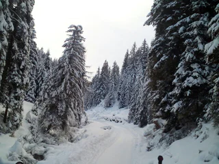
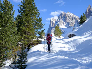
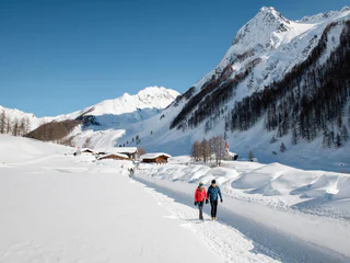
Winter hike: The Stumpfalm hut in the Gsiesertal Valley 2000 m
S. Maddalena/St. Magdalena - Casies/Gsies, Gsies/Valle di Casies
medium
Obtížnost
503 m
Převýšení
2h:00 min
doba trvání
Během zimních túr po upravených stezkách poznáte klidnou stránku Jižního Tyrolska. Objevte okouzlující vyhlídky v Dolomitech, zasněžené lesy v tichých bočních údolích a vychutnejte si přírodu na vlastní pěst v absolutním tichu. Na sněžnicích se vydáte daleko od sjezdovek a lanovek do nedotčených lesů. Tak se turistika na sněžnicích a zimní turistika stává skutečným zážitkem.
S. Maddalena/St. Magdalena - Casies/Gsies, Gsies/Valle di Casies
medium
Obtížnost
503 m
Převýšení
2h:00 min
doba trvání
S. Maddalena/St. Magdalena - Casies/Gsies, Gsies/Valle di Casies
easy
Obtížnost
239 m
Převýšení
1h:00 min
doba trvání
Nove Case/Neunhäusern, Rasen-Antholz/Rasun Anterselva, Dolomites Region Kronplatz/Plan de Corones
easy
Obtížnost
20 m
Převýšení
2h:30 min
doba trvání
1/2
S. Candido/Innichen, Toblach/Dobbiaco, Dolomites Region 3 Zinnen
easy
Obtížnost
319 m
Převýšení
2h:00 min
doba trvání
1/8
Montesole/Sonnenberg - Parcines/Partschins, Partschins/Parcines, Meran/Merano and environs
easy
Obtížnost
123 m
Převýšení
1h:30 min
doba trvání
1/3
Redagno/Radein, Aldein/Aldino
easy
Obtížnost
157 m
Převýšení
1h:25 min
doba trvání
Mendelpass, Kaltern an der Weinstraße/Caldaro sulla Strada del Vino, Alto Adige Wine Road
easy
Obtížnost
241 m
Převýšení
1h:30 min
doba trvání
Villabassa/Niederdorf, Niederdorf/Villabassa, Dolomites Region 3 Zinnen
easy
Obtížnost
48 m
Převýšení
1h:03 min
doba trvání
Obereggen/Obereggen, Deutschnofen/Nova Ponente, Dolomites Region Eggental
medium
Obtížnost
519 m
Převýšení
3h:00 min
doba trvání
1/2
Antholz-Obertal/Anterselva di Sopra, Rasen-Antholz/Rasun Anterselva, Dolomites Region Kronplatz/Plan de Corones
easy
Obtížnost
0 m
Převýšení
0h:30 min
doba trvání
1/2
S. Maddalena/St. Magdalena - Funes/Villnöss, Brixen/Bressanone, Brixen/Bressanone and environs
medium
Obtížnost
468 m
Převýšení
3h:00 min
doba trvání
1/5
Avelengo Paese/Hafling Dorf, Hafling/Avelengo, Meran/Merano and environs
medium
Obtížnost
477 m
Převýšení
3h:25 min
doba trvání
Mazia/Matsch, Taufers im Münstertal/Tubre, Vinschgau/Val Venosta
easy
Obtížnost
502 m
Převýšení
1h:43 min
doba trvání
1/3
Alpe di Siusi/Seiseralm, Kastelruth/Castelrotto, Dolomites Region Seiser Alm
medium
Obtížnost
524 m
Převýšení
4h:24 min
doba trvání
1/9
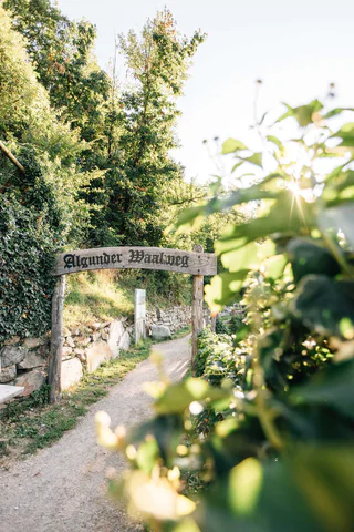
Lagundo/Algund, Algund/Lagundo, Meran/Merano and environs
easy
Obtížnost
29 m
Převýšení
1h:08 min
doba trvání
Anterselva di Sopra/Antholz-Obertal, Rasen-Antholz/Rasun Anterselva, Dolomites Region Kronplatz/Plan de Corones
medium
Obtížnost
360 m
Převýšení
1h:45 min
doba trvání
Valgiovo/Jaufental, St.Leonhard in Passeier/San Leonardo in Passiria, Meran/Merano and environs
easy
Obtížnost
86 m
Převýšení
0h:30 min
doba trvání
1/2
Casere/Kasern, Prettau/Predoi, Ahrntal/Valle Aurina
easy
Obtížnost
98 m
Převýšení
1h:15 min
doba trvání
1/2
Martello/Martell, Martell/Martello, Vinschgau/Val Venosta
easy
Obtížnost
147 m
Převýšení
1h:46 min
doba trvání

1/4
Avelengo Paese/Hafling Dorf, Hafling/Avelengo, Meran/Merano and environs
easy
Obtížnost
79 m
Převýšení
0h:49 min
doba trvání
Caminata di Tures/Kematen, Sand in Taufers/Campo Tures, Ahrntal/Valle Aurina
medium
Obtížnost
694 m
Převýšení
2h:30 min
doba trvání
Sesto/Sexten, Sexten/Sesto, Dolomites Region 3 Zinnen
medium
Obtížnost
100 m
Převýšení
0h:30 min
doba trvání
1/3
La Val/La Val, La Val, Dolomites Region Alta Badia
easy
Obtížnost
528 m
Převýšení
3h:34 min
doba trvání
medium
Obtížnost
0 m
Převýšení
2h:00 min
doba trvání
1/5
Maranza/Meransen, Mühlbach/Rio di Pusteria, Brixen/Bressanone and environs
easy
Obtížnost
258 m
Převýšení
1h:36 min
doba trvání
1/5
Postal/Burgstall, Vöran/Verano, Meran/Merano and environs
easy
Obtížnost
187 m
Převýšení
0h:40 min
doba trvání
1/4
Vallesina/Versein, Mölten/Meltina, Bolzano/Bozen and environs
easy
Obtížnost
202 m
Převýšení
0h:43 min
doba trvání
1/2
Alpe di Siusi/Seiseralm, Kastelruth/Castelrotto, Dolomites Region Seiser Alm
medium
Obtížnost
415 m
Převýšení
2h:28 min
doba trvání
Solda/Sulden, Stilfs/Stelvio, Vinschgau/Val Venosta
easy
Obtížnost
172 m
Převýšení
2h:04 min
doba trvání
Bolzano Centro/Bozen Zentrum, Bolzano/Bozen, Bolzano/Bozen and environs
medium
Obtížnost
426 m
Převýšení
2h:22 min
doba trvání


