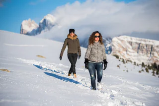
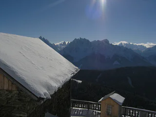
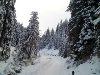
Südtirol Guide App Logo
Passer au contenu

ajouté(e) aux favoris

supprimé(e) des favoris

Oups ! Une erreur s’est produite. Réessayer

Ton compte est en cours de création

Ton compte a été créé avec succès et tu es maintenant connecté

Tu es connecté!

Ton compte a été créé avec succès, mais nous n'avons pas pu te connecter automatiquement

Tu es déconnecté

Filtrer
Filtres sélectionnés
    Niveau de difficulté
    Durée
    Distance en km

    Randonnées hivernales dans les Dolomites

    La randonnée hivernale sur les sentiers tracés te permettra de découvrir le côté paisible de l'hiver. Découvre des points de vue enchanteurs dans les Dolomites, des forêts enneigées dans des vallées latérales tranquilles et profite uniquement de toi-même et de la nature dans un silence absolu. La randonnée hivernale devient ainsi une véritable expérience.

    Résultats
    Hiking
    Winter hike: The Taistner Alm hut in Tesido 2012 m
    Welsberg-Taisten/Monguelfo-Tesido

    A well-known hut with a beautiful view

    Starting point: Monguelfo-Tesido – Tesido, parking lot above the mountain farm Mudler (1620 m)
    Distance: 4,1 km
    Descent: along the ascending route
    Walking time: 01:30 h
    Difficulty: easy
    Difference in altitude: 392m
    Tobogganing possibility: yes / difficulty easy
    Information: also feasible with snow shoes or touring skis

    Difficulté : moyenne
    420 m altitude
    1h:30 min durée
    Hiking
    Winter hike: Hiking amongst farms in Tesido
    Welsberg-Taisten/Monguelfo-Tesido

    Hike passing by characteristic farms

    Starting point: Monguelfo-Tesido – Tesido, tourist office (1206 m)
    Distance: 8 km
    Descent: circular route
    Duration: 02:40 h
    Difficulty: medium
    Difference in altitude: 300 m
    Possibility of sledding: no

    Difficulté : moyenne
    300 m altitude
    2h:30 min durée
    Long-Distance Hiking Paths
    Winter hike: Hiking along the Via Romana in Monguelfo
    Niederdorf/Villabassa, Dolomites Region 3 Zinnen

    Home of mountain farmers: hike from Monte Eggerberg mountain to Villabassa

    Starting point: Monguelfo-Tesido – Monguelfo, school center (1112 m)
    Distance: 8 km
    Descent: with public transportation
    Duration: 02:45 h
    Difficulty: medium
    Difference in altitude: 348 m
    Possibility of sledding: no

    Difficulté : moyenne
    320 m altitude
    2h:30 min durée
    Barrier-Free
    Winter trail: Niederdorf/Villabassa - Aufkirchen/Santa Maria - Toblach/Dobbiaco - Niederdorf/Villabassa
    Niederdorf/Villabassa, Dolomites Region 3 Zinnen

    This pleasant circular hike begins in Niederdorf and follows the peaceful Rienz River, where the gentle murmur of the water and the calm valley landscape create an inviting start. At Neunhäusern, a gradual ascent takes you through meadows and light woodland up to Aufkirchen – a charming hamlet with traditional farms and panoramic views of the Dolomites.

    From there, the route descends gently toward Toblach along a quiet road, offering open views of the Upper Puster Valley and the surrounding peaks. The return to Niederdorf is an easy walk along a flat, paved road, perfect for a leisurely finish.

    A lovely tour for those who appreciate nature, scenic views, and a relaxed pace – ideal for a mindful and restorative day outdoors.

    Difficulté : facile
    600 m altitude
    4h:30 min durée
    Summer
    Winter hike: Along the “Talblickweg” path in the Val Casies/Gsiesertal Valley
    Gsies/Valle di Casies

    The panoramic street of the Val Casies Valley

    Starting point: Val Casies/Gsiesertal Valley – S. Maddalena, Head of the valley (1465 m)
    Distance: 16,5 km
    Descent: using public transport
    Walking time: 05:00 h
    Difficulty: easy
    Difference in altitude: 200 m
    Tobboganing possibility: no
    Information: Depending on weather conditions: with freshly fallen snow only accessible with snow shoes.

    Difficulté : facile
    268 m altitude
    4h:28 min durée
    Hiking
    Winter hike on the Hans and Paula Steger trail
    Kastelruth/Castelrotto, Dolomites Region Seiser Alm

    Ski racers and mountaineers Hans and Paola Steger made their mark on the Seiser Alm like no other, before or since. Pioneers of mountaineering in the Dolomites, they made an immense contribution to the development of skiing on the Seiser Alm: The Hans & Paola Steger trail pays homage to their achievements. Info boards lining the route provide a host of information on the nature and culture of the Seiser Alm. A magnificent Dolomite panorama accompanies hikers along this leisurely yet fascinating trail. 

    Difficulté : moyenne
    299 m altitude
    2h:55 min durée
    Hiking
    Winter hike: The Moos Alm hut in the Val Casies/Gsiesertal Valley 1477 m
    Gsies/Valle di Casies

    For winterlovers

    Starting point: Val Casies/Gsiesertal Valley – S. Maddalena, Head of the valley (1465 m)
    Distance: 0,5 km
    Descent: along the ascending route
    Walking time: 00:10 h
    Difficulty: easy
    Difference in altitude: 12m
    Tobogganing possibility: no
    Information: Directly at the cross country track

    Difficulté : facile
    11 m altitude
    0h:12 min durée
    Hiking
    Winter hike to the Molignon refuge
    Kastelruth/Castelrotto, Dolomites Region Seiser Alm

    This beautiful winter hike to the Mahlknechthütte leads right over the Seiser Alm. Endless snow-blanketed Alpine meadows, idyllic Alpine huts and breathtaking views into the distance and depths are guaranteed to enchant hikers on this peaceful tour far from the commotion of the ski resorts.

    Difficulté : moyenne
    524 m altitude
    4h:24 min durée
    Hiking
    Winter hike: The Stumpfalm hut in the Val Casies/Gsiesertal Valley 2000 m
    Gsies/Valle di Casies

    Through a marvellous winter forest

    Starting point: Val Casies/Gsiesertal Valley – S. Maddalena, Head of the valley (1465 m)
    Distance: 5 km
    Descent: along the ascending route
    Walking time: 02:00 h Difficulty: medium
    Difference in altitude: 536 m
    Tobboganing possibility: yes / medium difficulty
    Information: also feasible with snowshoes or touring skis  

    Difficulté : moyenne
    503 m altitude
    2h:00 min durée
    Hiking
    Winter hike from Saltria to Zallinger refuge
    Kastelruth/Castelrotto, Dolomites Region Seiser Alm

    This winter hike starts in Saltria and leads past the Floralpina and Tirler hotels to the refuge Berghaus Zallinger and the church of the same name, in the immediate vicinity of the Plattkofel valley basin.

    Difficulté : moyenne
    382 m altitude
    2h:40 min durée
    Summer
    Winter hike: The Messnerhütte hut in the Val Casies/Gsiesertal Valley 1660 m
    Gsies/Valle di Casies

    Family friendly hike

    Starting point: Val Casies/Gsiesertal Valley – S. Maddalena, Head of the valley (1465 m)
    Distance: 3 km
    Descent: along the ascending route
    Walking time: 01:00 h
    Difficulty: easy
    Difference in altitude: 195 m
    Tobogganing possibility: yes / easy difficulty
    Information: also feasible with snowshoes or touring skis

    Difficulté : facile
    200 m altitude
    0h:49 min durée
    Summer
    Winter hike hut Gampen
    Villnöss/Funes, Dolomites Region Villnösstal
    Beautiful circular hike to the hut Gampenalm with a magnificent view of the Geisler peaks.
    Difficulté : moyenne
    400 m altitude
    2h:13 min durée
    Summer
    Sun Trail-Panoramic Trail
    Villnöss/Funes, Dolomites Region Villnösstal

    A beautiful circular hike between the villages of St. Peter and St. Magdalena with ancient wayside shrines and a magnificent view of the Geisler Mountains. Also ideal for jogging!

    Difficulté : facile
    322 m altitude
    2h:01 min durée
    Hiking
    Winter hike to Mont Seuc
    Kastelruth/Castelrotto, Dolomites Region Seiser Alm
    This hike offers an impressive view of the Lang- and Plattkofel mountains (Sassolungo and Sassopiatto). The trail runs across extensive snow-covered Alpine meadows.
    Difficulté : moyenne
    351 m altitude
    3h:37 min durée
    Hiking
    Winter hike on the Puflatsch
    Kastelruth/Castelrotto, Dolomites Region Seiser Alm

    This hike offers a breathtaking 360° view of the surrounding mountains. Highlights of this circular hike are the legendary witches' benches, the Filln cross and the observation platform Engelsrast.

    Difficulté : moyenne
    406 m altitude
    2h:43 min durée
    Hiking
    Winter hike: The Uwald Alm hut in the Val Casies/Gsiesertal Valley 2042 m
    Gsies/Valle di Casies

    Where you get the most beautiful view of the valley

    Starting point: Val Casies/Gsiesertal Valley – S. Maddalena, Head of the valley (1465 m)
    Distance: 5 km
    Descent: along the ascending route
    Walking time: 01:30 – 02:00 h
    Difficulty: medium
    Difference in altitude: 577 m
    Tobboganing possibility: yes
    Information: also feasible with snowshoes or touring skis  

    Difficulté : moyenne
    577 m altitude
    2h:00 min durée
    Barrier-Free
    Winter trail: Niederdorf/Villabassa - Mooskircherunde/Passeggiata "Mooskirche" circuit - Niederdorf/Villabassa
    Niederdorf/Villabassa, Dolomites Region 3 Zinnen

    The hike starts in the center of Niederdorf at the Spitalkirche (Church). The path follows the edge of the forest towards the picturesque Moos Chapel, offering constant views of the charming village and the majestic backdrop of the Pragser Dolomites. Upon reaching the small Gothic chapel of St. Magdalena im Moos, also known as the "Moos Chapel," inviting benches welcome you to rest and reflect – a perfect spot to soak in the peaceful atmosphere and the stunning natural surroundings.

    The return route leads gently back along a paved road, surrounded by expansive fields, returning to the village – a lovely opportunity to savor the tranquility of nature once more.

    Difficulté : facile
    21 m altitude
    0h:37 min durée
    Hiking
    Winter hike: Panoramic hike in the Val Casies/Gsiesertal Valley
    Gsies/Valle di Casies

    Hike amongst characteristic hamlets: Schintlholz/Schintlholz, Hölzl, Prati di Tesido

    Starting point: Val Casies/Gsiesertal Valley – Colle, parish church (1260 m)
    Distance: 6 km
    Descent: along the same route or by public transport
    Duration: 02:00 h
    Difficulty: medium
    Difference in altitude: 300 m
    Possibility of sledding: no

    Difficulté : facile
    200 m altitude
    3h:00 min durée
    Barrier-Free
    Nature Trail Zans
    Villnöss/Funes, Dolomites Region Villnösstal

    The Nature Trail Zans is accessible for wheelchairs. Fourteen sections give an insight in the flora and fauna of the Nature Park Puez-Geisler.

    Hiking time: 1h 

    Difficulté : facile
    90 m altitude
    0h:51 min durée
    Summer
    Winter hike: Passing by historic farmsteads and farmhouses
    Gsies/Valle di Casies

    Circular hike to the head of the valley in the Val Casies/Gsiesertal Valley 

    Starting Point: Val Casies/Gsiesertal Valley – S. Maddalena, Head of the valley, Parish church (1400 m)
    Distance: 6 km
    Descent: circular hike
    Walking time: 01:50 h
    Difficulty: medium
    Difference in altitude: 175 m
    Information: Depending on weather conditions: with freshly fallen snow only accessible with snow shoes.

    Difficulté : facile
    222 m altitude
    1h:43 min durée
    Hiking
    Winter hike: The Kradorfer Alm hut in the Val Casies/Gsiesertal Valley 1704 m
    Gsies/Valle di Casies

    Hiking fun for all ages

    Starting point: Val Casies/Gsiesertal Valley – S. Maddalena, Head of the valley (1465 m)
    Distance: 3,5 km
    Descent: along the ascending route
    Walking time: 01:10 h
    Difficulty: easy
    Difference in altitude: 239 m
    Tobogganing possibility: yes / easy difficulty
    Information: also feasible with snowshoes or touring skis

    Difficulté : facile
    239 m altitude
    1h:00 min durée
    Hiking
    Saltria - Piz - Saltria
    Kastelruth/Castelrotto, Dolomites Region Seiser Alm

    This winter hike starts in Saltria and leads along the hiking trail towards Piz. From there the trail runs through the snow-covered landscape with a wonderful panoramic view of the Dolomites.

    Difficulté : moyenne
    344 m altitude
    2h:31 min durée
    Hiking
    Winter hike: Panoramic hike in Tesido
    Welsberg-Taisten/Monguelfo-Tesido

    Towards the Dolomites

    Starting point: Monguelfo-Tesido – Tesido, tourist office (1206 m)
    Distance: 3,5 km
    Descent: along the ascending route
    Duration: 01:00 h
    Difficulty: easy
    Difference in altitude: 171 m
    Possibility of sledding: no

    Difficulté : facile
    165 m altitude
    1h:00 min durée
    Hiking
    Winter hike: Hiking from Monguelfo to the dam of Valdaora
    Welsberg-Taisten/Monguelfo-Tesido

    Along the shores of the Rienza river to the Salla hamlets

    Starting point: Monguelfo-Tesido – Monguelfo, tourist information office (1087 m)
    Distance: 6 km
    Descent: circular hike
    Duration: 03:45 h
    Difficulty: medium
    Difference in altitude: 180 m
    Possibility of sledding: no

    Difficulté : facile
    327 m altitude
    4h:00 min durée
    Hiking
    Winter hike to the Sanon Hut
    Kastelruth/Castelrotto, Dolomites Region Seiser Alm

    This pleasant walk leads from Compatsch towards Saltria, passing the Ritsch hut and the Monte Piz and over vast mountain meadows to the Sanon hut on a relaxing traverse of the Seiser Alm. The Alpine pastures and mountain huts along the route provide a welcome destination for a relaxing break.

    Difficulté : facile
    160 m altitude
    2h:13 min durée
    Hiking
    Winter hike: To the Gallfallalm huts 1667m in the Val Casies/Gsiesertal Valley
    Gsies/Valle di Casies

    Hike from S. Martino to the Karbacher Tal Valley

    Starting point: Val Casies/Gsiesertal Valley – S. Martino, tourist information office (1276 m) or Karbacherhof farm (1425 m)
    Distance: 5 km
    Descent: same way as ascent
    Walking time: 01:50 h
    Difficulty: medium
    Difference in altitude: 391 m S. Martino | 242 m maso Karbacherhof
    Tobogganing possibility: no
    Information: Depending on weather conditions: with freshly fallen snow in parts only accessible with snow shoes.

    Difficulté : facile
    230 m altitude
    1h:30 min durée
    1 2 3 4 5 6 7 8