Snowshoe Hikes
Mals/Malles, Vinschgau/Val Venosta
Snowshoe hiking with a view over the Mals Heath from Burgeis to the Faulen See Lake.
| Vinschgau vás okouzlí svou krásou a širokými možnostmi pro zimní sporty a rekreaci. |
The cross-country skiing trail in Schmelz, starting at the Hotel Waldheim at 1520m, is a forest hiking trail. Here it is allowed to hike on the cross-country trail, to go sledding and dogs are also allowed, but must be kept on a leash.
Please give priority to cross-country skiers!
Winter walk along the Plima river in the fairy-tale winter landscape of Val Martello.
From the Glieshöfe farms to Tanas:
Difference in height: 780 hm
Descent: 1.060 hm
Length: 21,7 km
Duration: 6 - 6,5 h
The berry bear trail with wooden sculptures and information boards for children and adults on the Schludernser Berg mountain.
From the Lake Gioveretto up to the Grün- and Gelbsee Lake until the Gioveretto Peak with its wondreful view.
The cross-country skiing trail in Schmelz, starting at the Hotel Waldheim at 1520m, is a forest hiking trail. Here it is allowed to hike on the cross-country trail, to go sledding and dogs are also allowed, but must be kept on a leash.
Please give priority to cross-country skiers!
From Stilfs/Stelvio to the Düsseldorfer hut:
Difference in height: 1.796 hm
Descent: 397 hm
Length: 17 km
Duration: ca. 9h
A beautiful but technically more demanding trail and mountain run that passes directly beneath the Ortler, Monte Zebrù and Königspitze triumvirate.
The last great waterwaal of the Val Venosta Valley dates back to 1873, using the waters of the Adige River near Goldrain at an altitude of 660 metres and ending after 6 kilometres in Galsaun, municipality of Castelbello.
Short, pleasant route along the "Kondlwaal "irrigation channel to Greithof and back to the Stallwies inn.
The old church-path from Tanas to the church of St. Peter became a way of calm and quiet. The meditation trail leads from Tanas to the church of St. Peter, with 4 wooden sculptures of the artist Ruth Schönthaler and offers a great view over the central Venosta Valley and the mountains of the Ortler group.
The start of the fourth stage of the circular hiking trail 360° Upper Vinschgau Valley is the mountaineering village Matsch/ Mazia. Along this stretch, you will experience the numerous cultural highlights of the Upper Vinschgau Valley.
In the about 3 kilometers long loop road, twelve stations invite young and old to play and discover. Zipf and Zapf go along with the little natural scientists on their walk and narrate them interesting facts about the forest and its inhabitanst. At the same time the children have to crack several riddles to find the mysterious treasure at the end of the road. The trail is positioned amid of the talai forest in San Valentino. Don't forget to take paper and pencil to note the answers. Preprints also available at the Tourist Information.
From Planol to the Glieshöfe farms:
Difference in height: 1,633 hm
Descent: 1,391 hm
Length: 26.8 km
Duration: 9.5 - 10 h
From Resia to Planol/Planeil:
Difference in height: 956 hm
Descent: 920 hm
Length: 20,5 km
Duration: 6 - 6,5h
The trail is located in the Stilfserjoch National Park and leads through a forest of spruce and larch.
Five information boards provide information about the history of the inclined railway:
the valley station and the construction of the incline railway from 1929
technical data about the incline railway
the St Martin church constructed in the 17th century, as well as marble transport in times before the construction of the incline railway when boulders were transported into the valley by means of brake slides,
hemp-rope pulleys and flatbed wagons pulled by oxen
the mountain station with the machine house, the drive engine and the cylinder rope winch
a brief company profile of the marble works in Lasa and a list of the historical mining sites
The hike can be done as a circular route, in combination with a visit to the “Gurgl” gorge in the lower Laaser Tal valley.
This section of the hike is not recommended for those uncomfortable with heights. All others can go along the trail through the Laaser Tal valley.
The eighth stage is the most demanding tour of the circular hiking trail 360° Upper Vinschgau Valley. The Tellajoch surprises with a typical 360° panoramic view to the mountain peaks of the Ortler group and the Sesvenna group. The 360° viewing platform titles the mountainous panorama.
From there it continues with insights into the Upper Vinschgau Valleys alpine pasture to Schlinig/ Slingia.
Eight churches from various eras, along a well-signed circular trail in Taufers i. M.
From the Stelvio Pass to Stilfs/Stelvio:
Difference in height: 335 hm
Descent: 1.811 hm
Length: 18,5 km
Duration: ca. 7,5h
The cross-country skiing trail in Schmelz, starting at the Hotel Waldheim at 1520m, is a forest hiking trail. Here it is allowed to hike on the cross-country trail, to go sledding and dogs are also allowed, but must be kept on a leash.
Please give priority to cross-country skiers!
An easy winter hike to the Matscheralm on the groomed winter trail. Perfect for families.
Starting point: North lakeshore of the Lake Haider in S. Valentino alla Muta Ascent: Along the western lakeshore to the southern end of the Lake Haider, then take the road on the right side, along the trail number 8 for Lake Faulensee. Turn right again to the old alpine path, which goes into Zerzertal. Pass the St. Martin Church and walk up the bridge just before the alpine pasture Malga Brugger/Brugger Alm (it is closed in winter). Over the lower trail number 7 across the Petsch forest in north direction back to the village St. Valentin. Arrived at the forest road, the way goes further on the skiing slope. Down to Plagött (posibility to stop for a bite to eat), and on to the valley station of the Malga S. Valentino/Haideralm.
Spring and autumn are the ideal times for this hike. From the sports ground in Lasa/Laas, walk along the dry Lasa Leitenwaal canals (Laaser Leiten) to the mountain village of Tanas. From here hikers can enjoy unique panoramic views of the valley basin and the Ortler range on the opposite side.
This hike is normally snow-free, with gorgeous views of the Laaser Tal valley, the marble quarry and the incline railway.
The new Ortler High Mountain Trail extends around the Stelvio National Park, from Venosta Valley in South Tyrol to Valtellina in Lombardy. With an altitude performance of 8,126 m across the entire route, this high Alpine hike circumnavigates the Ortler Group, in sections running at over 3,000 m altitude, and is one of the most demanding high-altitude routes in the Alpine region. Here, everything is demanded of even the most experienced mountain hikers: surefootedness, good fitness and suitable equipment are basic requirements for the seven-day tour, as one section runs over glacial terrain. The company of a mountain guide is recommended.
The Ortler High Mountain Trail is approximately 119.5 km long, and offers a highly unique experience in nature. It is divided into seven daily stages, each of which can be completed in six to eight hours. The individual stages of the circular hike can also be undertaken as eventful single-day hikes exploring the wide variety of local fauna and flora in the Stelvio National Park. The ideal time for all experienced mountain hikers is between June to September, with mild temperatures and clear visibility offering a unique panoramic view of the Ortler Group glaciers. Each stage of this high Alpine circular hiking trail offers its own special scenic highlights in the truest sense of the word.
The designated Alpine pastures and mountain huts along this high Alpine route are working farms and offer both food and accommodation to hikers.
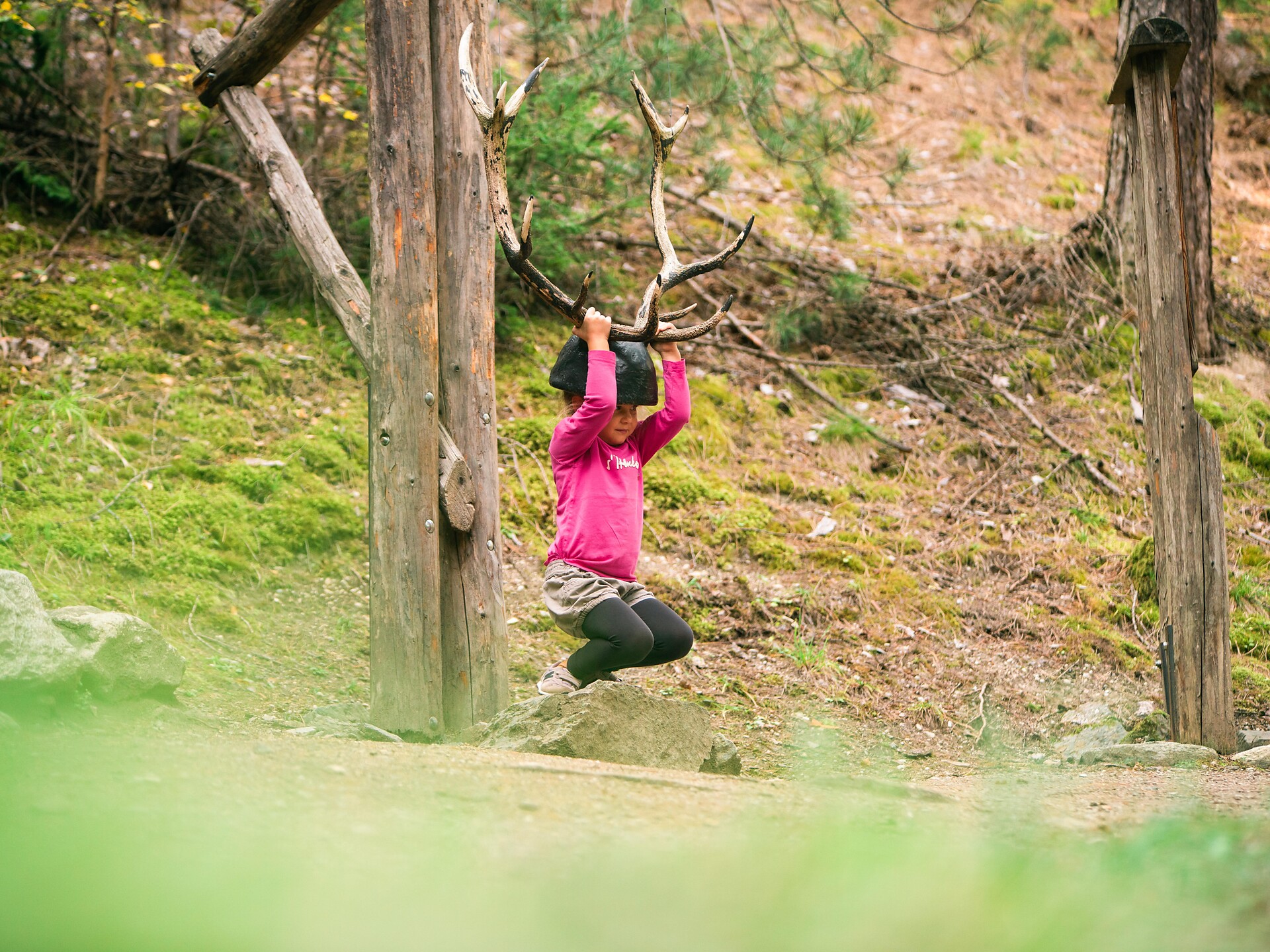
In 15 interesting stations, many different games await the families. Together with the wood mouse Ferdinand, the parents and their kids search for animal tracks, listen to bird voices, lift up the horn of a deer, work themselves through a tunnel and climb up the pecker-hill.
Beautiful circular snowshoe hike across the Eisa meadows to the Matscher Alm.
Short and pleasant loop between Prad and the Prader fishing ponds.