Přeskočit na obsah

přidáno k oblíbeným

odebráno z oblíbených

Jejda! Došlo k problému, zkuste to prosím znovu

Vytváří se váš účet

Váš účet byl úspěšně vytvořen a nyní jste přihlášeni

Jste úspěšně přihlášeni!

Váš účet byl úspěšně vytvořen, ale nepodařilo se nám vás automaticky přihlásit

Jste odhlášeni

Filtr
Vybrané filtry
    Úroveň obtížnosti
    Doba trvání
    Vzdálenost v km

    Objevte krásy Vinschgau

    Vinschgau vás okouzlí svou krásou a širokými možnostmi pro zimní sporty a rekreaci.
    Výsledky
    Running & Fitness
    Trail Elfer peak
    Mals/Malles, Vinschgau/Val Venosta
    A very beautiful, alpine trail running loop with a magnificent view of Lake Reschen and the Ortler Group. The tour is signposted from Haideralm via the Elferspitze to the Schöneben cable car and, due to the moderate distances, is suitable for beginners as well. The ascent to the Elferspitze can be managed with some surefootedness. The route leads across simple block terrain over the Zwölferkopf down to the Schöneben hut. Afterwards, you can take the Schöneben cable car and bus back to the Haideralm valley station. If you want to extend the tour a bit, you can run the dreamy high-altitude trail from the Schöneben mountain station to the Haideralm mountain station. Of course, the tour can also be started from Schöneben
    Obtížnost: vysoká
    1120 m nadmořská výška
    4h:55 min doba trvání
    Mountaineering
    Solda–Passo del Madriccio–Val Martello
    Stilfs/Stelvio, Vinschgau/Val Venosta

    The high mountain tour from Solda across the Madriccio Pass is a slightly steep path to the Passo del Madriccio, where you can enjoy a fabulous panoramic view. Marvel at Ortler, Zebru and Gran Zebru as well as at the glaciers around Cima Cevedale and Monte Cevedale. Also the descent to the Rifugio Martello and Rifugio Corsi is absolutely a highlight.

    Obtížnost: střední
    529 m nadmořská výška
    3h:08 min doba trvání
    Lifts
    Magic carpet Grogg
    Martell/Martello, Vinschgau/Val Venosta

    The biathlon centre "Grogg" in Val Martello, famous far beyond the borders, offers guest biathlon, competitions, 12km of wonderful cross-country ski trails and a 100m long magic carpet for tobogganing, snow tubing and small skiers.

    Magic carpet - ski conveyor belt at the Val Martello biathlon centre
    A 100m long ski conveyor belt takes the kids to the start on a beginners slope and off they go skiing. Whether with the skis or with the toboggan - everyone will find his place.


    Obtížnost: nízká
    0 m nadmořská výška
    0h:00 min doba trvání
    Mountaineering
    To the Punta Beltovo di Dentro/Hintere Schöntaufspitze
    Stilfs/Stelvio, Vinschgau/Val Venosta

    The Punta Beltovo di Dentro/Hintere Schöntaufspitze is one of the easiest three thousand metre peaks in South Tyrol. From its peak you can enjoy a beautiful view of the mountains of the Martell Valley. On the way to the peak you can stop at the rif. Madriccio to get some refreshments.

    Obtížnost: střední
    725 m nadmořská výška
    2h:30 min doba trvání
    Snowshoe Hikes
    "Suachbichl" viewpoint
    Martell/Martello, Vinschgau/Val Venosta

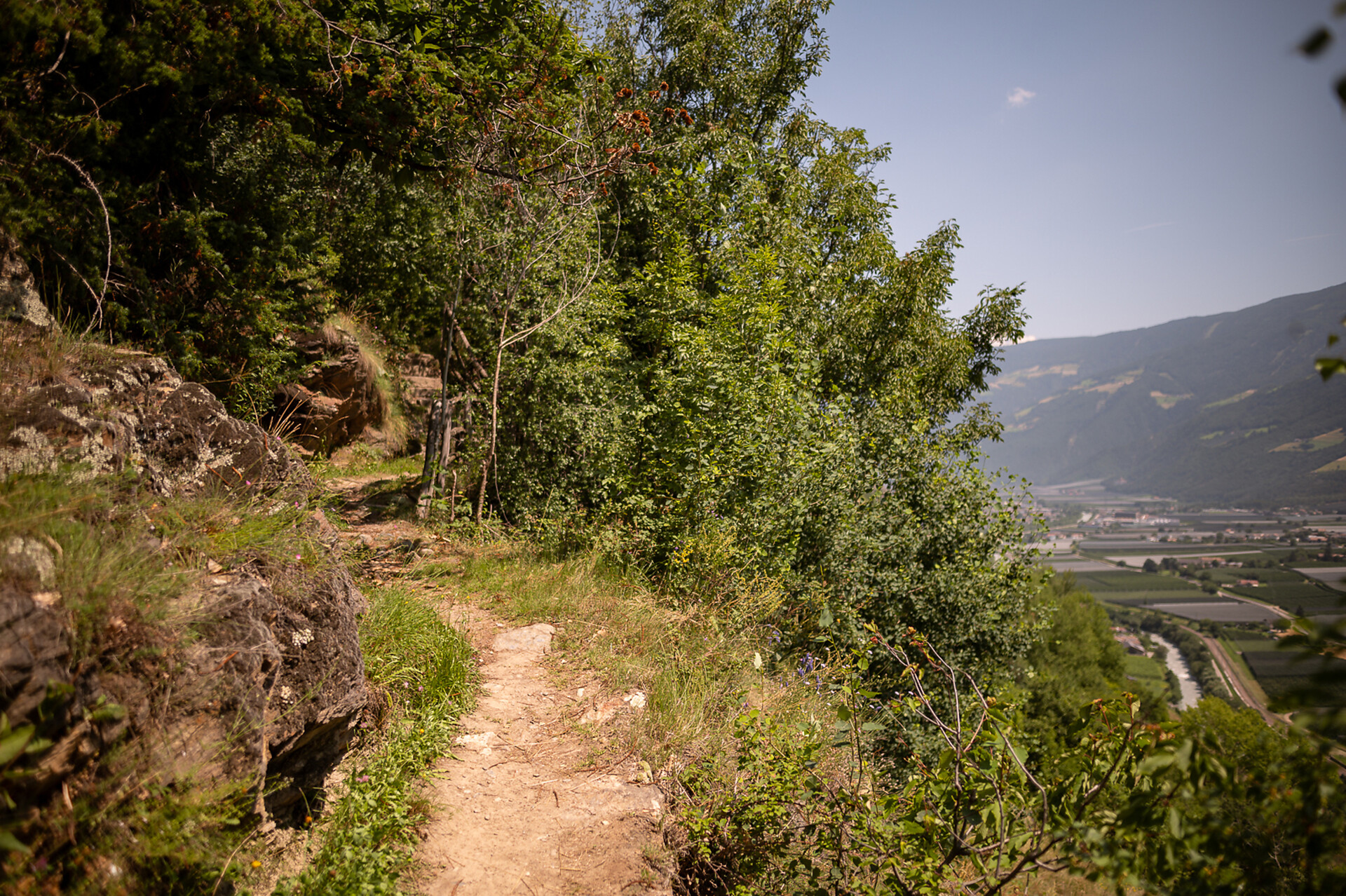
    Discover the area of the Kondlwaal (wooden irrigation channel) and sunny Selva from Europe’s highest corn farm.

    Obtížnost: nízká
    269 m nadmořská výška
    1h:33 min doba trvání
    Themed Hikes
    Schnalswaal irrigation channel
    Kastelbell-Tschars/Castelbello-Ciardes, Vinschgau/Val Venosta

    Schnalswaal irrigation channel has been in use for more than 500 years and offers plenty to see: a Waalerhütte hut, a functional Waalschelle bell, chestnut woods, steppic vegetation, and, of course, Juval castle.

    Obtížnost: nízká
    300 m nadmořská výška
    3h:00 min doba trvání
    Hiking
    Jochwaal di Tarres
    Latsch/Laces, Vinschgau/Val Venosta
    A unique loop trail: Sure-footedness is required to reach this Waal trail, one of the highest in the entire Alps. Tarscher Jochwaal, no longer in use nowadays, was originally built in the 18th century.

    Refreshment stop:
    Latscher Alm hut, Tarscher Alm hut and Tarscher Alm mountain restaurant

    Water course:
    No water flow
    Obtížnost: střední
    689 m nadmořská výška
    2h:40 min doba trvání
    Running & Fitness
    Elevation Trail Nauders
    Graun im Vinschgau/Curon Venosta, Vinschgau/Val Venosta
    A top-class trail run! After a longer ascent, the high-altitude trail runs permanently along the forest border to Italy and Lake Reschen. From the starting point Parditsch in Nauders, you follow the trail to the inn of the same name and continue to the Labaunalm. Now you branch off to the south and follow the trail to the Labauner Köpfl. The long ascent is now overcome, and you can really enjoy the trails with a great view of Lake Reschen and the surrounding mountains. At the Piengalm, after about 14 km, you can stock up on food and drinks before the high-altitude trail climbs slightly again towards Bergkastel. Now you have almost completed all the altitude meters and continue across the border to Italy to the Plamort rock. The downhill is rewarded with a fantastic view of Lake Reschen. Soon the forest road is reached, along which you run the last kilometer to Reschen.
    Obtížnost: vysoká
    1344 m nadmořská výška
    7h:37 min doba trvání
    Lifts
    Cabin lift Belpiano
    Graun im Vinschgau/Curon Venosta, Vinschgau/Val Venosta

    The skiing area in the middle of the lake landscape in Reschen does justice to its name: 15 lifts, snow guarantee until spring and wide slopes offer variety for families, snowboarders and skiers. 65 kilometres of perfectly groomed pistes and the lifts promise a varied skiing day in the Venosta valley. A skiing area for families

    In summer, the Schöneben cable car takes both hikers and bikers to the top. Once you reach the top, it is a true paradise for active holidays. Especially the 3-country Enduro Trails are a paradise for adrenalin junkies. You can take a break either in the mountain restaurant or in Sciuri at the valley station

    Obtížnost: nízká
    0 m nadmořská výška
    0h:00 min doba trvání
    Running & Fitness
    Morterer-Waal-Round via variant Montani
    Latsch/Laces, Vinschgau/Val Venosta

    Beautiful scenic running track at the south of Morter with a great variation over the castle ruins of Montani.

    Obtížnost: střední
    538 m nadmořská výška
    3h:34 min doba trvání
    Waalwege
    "Kastanienwaal" irrigation channel path
    Schlanders/Silandro, Vinschgau/Val Venosta
    Schlanderser Sonnenpromenade, the sun trail, lives up to its name, winding along Sonnenberg mountain, home to Mediterranean plants and chestnut trees, and through orchards down in the valley.

    Refreshment stop: In the inns in Schlanders
    Water flow: May-October
    Obtížnost: nízká
    70 m nadmořská výška
    0h:31 min doba trvání
    Running & Fitness
    Path along the water channel at Morter
    Latsch/Laces, Vinschgau/Val Venosta

    A scenic and beautiful running route in Morter which leaves nothing to be desired. Flat passages changes with moderate increases, to sensational sleep tracks along the "Neuwaal" and the "Rautwaal".


    Obtížnost: střední
    0 m nadmořská výška
    0h:40 min doba trvání
    Climbing
    Ferrata Trafoi
    Stilfs/Stelvio, Vinschgau/Val Venosta

    Ideal for beginners and children, the Trafoi via ferrata features a short ascent and descent. Thrill-seekers can soar right up to the entrance via the Flying Fox.

    Obtížnost: střední
    121 m nadmořská výška
    0h:25 min doba trvání
    Running & Fitness
    To the Melager Alm alpine pasture
    Graun im Vinschgau/Curon Venosta, Vinschgau/Val Venosta
    The running trail from Melag to the Melager Alm in Langtaufers is a scenic route for running enthusiasts. The run starts at the parking lot in the hamlet of Melag. From the parking lot, you run into the valley and turn right between the houses. Signs 2 and 5 mark the path, which is also clearly visible without markings. With a gentle incline, you jog to the Karlinbach, cross the bridge, and continue on a flat path to the alm. At the valley's end, there are impressive views of the snow-capped peaks surrounding the Weißkugel, with numerous three-thousanders flanking the valley to the north and south. The return is via the same route.
    As an alternative for runners, starting from the hamlet of Kappl at the former valley station of the Maseben lift is recommended, where you can follow the forest road to the Melager Alm
    Obtížnost: nízká
    146 m nadmořská výška
    0h:40 min doba trvání
    Themed Hikes
    "Stabnerwaal" irrigation channel path
    Naturns/Naturno, Vinschgau/Val Venosta

    The Stabner Waalweg trail is one of the most beautiful hikes at Sonnenberg mountain in Vinschgau valley. This family-friendly route pairs perfectly with a visit to Juval castle.

    Obtížnost: nízká
    160 m nadmořská výška
    2h:00 min doba trvání
    Hiking
    Marmotta peak
    Stilfs/Stelvio, Vinschgau/Val Venosta

    One of the classics in the Val Martello: glacier tour with fantastic views of the triumvirate of Königsspitze, Monte Zebru and Ortler as well as the Val Martello mountain Zufallspitze and Monte Cevedale.

    Obtížnost: vysoká
    1210 m nadmořská výška
    8h:45 min doba trvání
    Long-Distance Hiking Paths
    Family hike Watles
    Mals/Malles, Vinschgau/Val Venosta

    A leisurely hike on the Watles adventure mountain. Perfect for families, this tour leads from the Plantapatsch mountain hut through the picturesque forests of Watles.

    Obtížnost: nízká
    132 m nadmořská výška
    1h:19 min doba trvání
    Lifts
    Cable Car Solda
    Stilfs/Stelvio, Vinschgau/Val Venosta
    The Sulden cable car is one of the largest cable cars in the world and takes hikers and enthusiasts to the mountain station in comfort. The cabins offer space for up to 110 people per gondola at lofty heights. Once at the top, you can embark on numerous marked hiking trails or be enchanted by the mountain panorama surrounding King Ortler.
    Obtížnost: nízká
    0 m nadmořská výška
    0h:00 min doba trvání
    Themed Hikes
    Herbal path Flora TraFul
    Stilfs/Stelvio, Vinschgau/Val Venosta
    A world of medicinal and edible herbs grow on our doorstep.

    Along the Flora TraFul wild herb trail you’ll find information about our unique alpine plants and their multiple uses. The purpose of the Flora TraFul nature trail is to vividly illustrate how herbs are used in traditional folk medicine. Along the two-km-long hike, the rudiments of identification are explained, as well as the essentials of plant foraging, insights into herb processing, and the effects produced by some of the herbs.

    Starting point of the hike is the naturatrafoi Visitor Centre of Stelvio National Park, or at the bus stop.
    Obtížnost: nízká
    0 m nadmořská výška
    1h:40 min doba trvání
    Long-Distance Hiking Paths
    Alpine pastures panorama tour
    Mals/Malles, Vinschgau/Val Venosta

    The fantastic Alpine pasture panorama tour starts in the Schlinig Valley and continues via the Planatapatsch hut on the Watles adventure mountain to the Sesvenna mountain hut. Constantly accompanied by a marvellous panorama, this tour is a real treasure for all hiking and nature enthusiasts.

    Obtížnost: střední
    665 m nadmořská výška
    5h:00 min doba trvání
    Lifts
    Cable car Malga San Valentino
    Graun im Vinschgau/Curon Venosta, Vinschgau/Val Venosta
    The Haideralmbahn, which is centrally located in the village, shines in winter with offers for everyone. From winter hikes, beginner's slopes and wonder carpet to a fantastic downhill run. You can take a break in the restaurant right next to the mountain station, so that non-skiers can also enjoy a warm meal without any problems. A ski tour & snowshoe evening is also organised weekly

    In summer you will be taken to the wonderful hiking area. Children will enjoy the various attractions, while parents can pamper themselves on the magnificent panoramic terrace. The number of hiking possibilities knows no limits.
    A little insider tip: The panoramic trail Haideralm - Schöneben
    Obtížnost: nízká
    0 m nadmořská výška
    0h:00 min doba trvání
    Long-Distance Hiking Paths
    Long distance hike 2nd stage: Chamonna Tuoi CAS - Ardez
    Vinschgau/Val Venosta
    The second stage starts on the Chamonna Tuoi CAS and leads over the Lai Blau to Alp Sura and along the tree line to the village of Ardez, with its striking "Steinsberg".


    The route starts below the mighty Piz Buin in the direction of the picturesque Lai Blau (2,613 m above sea level), where it is worth taking a short break. Along the western flank you reach Alp Sura, which offers the ideal view for a short lunch break. Above the tree line with a magnificent view of the Lower Engadine and the unique villages, you hike via the hamlet of Munt d'Ardez to Ardez, the second stage destination.
    Obtížnost: střední
    435 m nadmořská výška
    4h:19 min doba trvání
    Running & Fitness
    Stelvio Trail
    Stilfs/Stelvio, Vinschgau/Val Venosta

    Very demanding but extremely rewarding trail to the peak of the Stelvio Pass.

    Obtížnost: vysoká
    1540 m nadmořská výška
    7h:25 min doba trvání
    Waalwege
    Raminiwaal irrigation channel path
    Latsch/Laces, Vinschgau/Val Venosta
    Discover old ruins, chimes, and picnic areas at Raminiwaal Trail in the Untervinschgau region. This pleasant, almost level trail connecting Tarsch and Morter is nicely shaded and offers plenty to explore.

    Refreshment stop:
    Knofelkeller in Tarres
    Zum Riesen in Tarres
    Restaurants in Laces

    Water course:
    May-October
    Obtížnost: nízká
    0 m nadmořská výška
    0h:54 min doba trvání
    Running & Fitness
    Joggl Trail
    Graun im Vinschgau/Curon Venosta, Vinschgau/Val Venosta
    A great challenging round over several peaks, but requiring some surefootedness and good weather. From Graun, you first follow the Panorama Trail (R6), turn off after about 3 km, cross the main road, and follow the trail up to the Joggl (Endkopf). Now you continuously follow the ridge over several peaks, up to the 2,909 m high Mittereggspitze, which offers a magnificent view of the Ortler. The route continues along the ridge, mostly downhill and over a last ascent to the summit of the Großhorn. Now you follow the path down the north side, past the Grauner Alm, and back to Graun to the starting point.
    Obtížnost: vysoká
    1950 m nadmořská výška
    9h:01 min doba trvání