
3-Country Elevation Path
Resia/Reschen, Graun im Vinschgau/Curon Venosta, Vinschgau/Val Venosta
medium
Difficulty
2424 m
Elevation gain
6h:00 min
duration
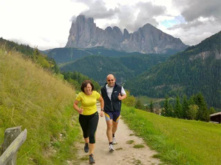
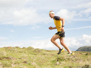
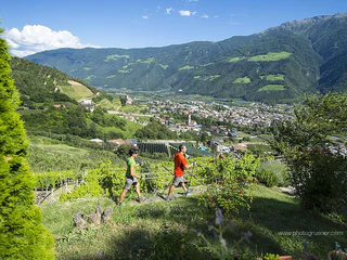
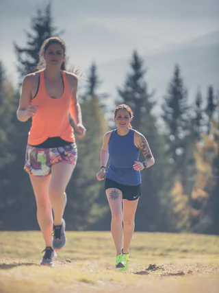
South Tyrol is the varied Mecca for runners. Whether uphill, downhill, flat, on asphalt, in forests, on meadows or over hill and dale: every runner gets his money's worth in South Tyrol. The offer of signposted and well-maintained running trails is large and ranges from the running paradise at the Reschensee to the healthy altitude training on the Seiser Alm.
Resia/Reschen, Graun im Vinschgau/Curon Venosta, Vinschgau/Val Venosta
medium
Difficulty
2424 m
Elevation gain
6h:00 min
duration
1/2
Ortisei/Urtijëi/St. Ulrich/Urtijëi, Urtijëi/Ortisei, Dolomites Region Val Gardena
medium
Difficulty
462 m
Elevation gain
2h:36 min
duration
Obereggen/Obereggen, Deutschnofen/Nova Ponente, Alto Adige Wine Road
medium
Difficulty
634 m
Elevation gain
2h:13 min
duration
S. Martino al Monte/St. Martin - Laces/Latsch, Latsch/Laces, Vinschgau/Val Venosta
medium
Difficulty
309 m
Elevation gain
2h:13 min
duration
1/4
Naturns/Naturno, Meran/Merano and environs
easy
Difficulty
5 m
Elevation gain
0h:09 min
duration
Vellau/Velloi, Algund/Lagundo, Meran/Merano and environs
medium
Difficulty
684 m
Elevation gain
2h:16 min
duration
Juvale/Juval, Kastelbell-Tschars/Castelbello-Ciardes, Vinschgau/Val Venosta
easy
Difficulty
154 m
Elevation gain
1h:43 min
duration
Scena/Schenna, Schenna/Scena, Meran/Merano and environs
easy
Difficulty
85 m
Elevation gain
0h:15 min
duration
1/2
Nobls/Nobls, Jenesien/San Genesio Atesino, Bolzano/Bozen and environs
easy
Difficulty
378 m
Elevation gain
2h:38 min
duration
Bolzano Centro/Bozen Zentrum, Bolzano/Bozen, Bolzano/Bozen and environs
easy
Difficulty
25 m
Elevation gain
1h:37 min
duration
Redagno/Radein, Aldein/Aldino
difficult
Difficulty
474 m
Elevation gain
2h:37 min
duration
Bolzano Centro/Bozen Zentrum, Bolzano/Bozen, Bolzano/Bozen and environs
medium
Difficulty
358 m
Elevation gain
3h:00 min
duration
San Nicolò/St. Nikolaus, Ulten/Ultimo, Meran/Merano and environs
difficult
Difficulty
493 m
Elevation gain
4h:55 min
duration
Monte Scena/Schennaberg, Schenna/Scena, Meran/Merano and environs
difficult
Difficulty
700 m
Elevation gain
1h:00 min
duration
Selva/Sëlva/Wolkenstein/Sëlva, Sëlva/Selva di Val Gardena, Dolomites Region Val Gardena
difficult
Difficulty
969 m
Elevation gain
5h:01 min
duration
Videgg/Videgg, Schenna/Scena, Meran/Merano and environs
easy
Difficulty
150 m
Elevation gain
0h:19 min
duration
1/3
Roncadizza/Runggaditsch - Ortisei/St.Ulrich, Kastelruth/Castelrotto, Dolomites Region Seiser Alm
medium
Difficulty
182 m
Elevation gain
1h:58 min
duration
Nove Case/Neunhäusern, Rasen-Antholz/Rasun Anterselva, Dolomites Region Kronplatz/Plan de Corones
medium
Difficulty
253 m
Elevation gain
3h:00 min
duration
Siusi/Seis, Kastelruth/Castelrotto, Dolomites Region Seiser Alm
easy
Difficulty
67 m
Elevation gain
1h:46 min
duration
Redagno/Radein, Aldein/Aldino
medium
Difficulty
621 m
Elevation gain
2h:34 min
duration
1/2
Avelengo Paese/Hafling Dorf, Hafling/Avelengo, Meran/Merano and environs
medium
Difficulty
448 m
Elevation gain
2h:45 min
duration
1/3
Naturno/Naturns, Naturns/Naturno, Meran/Merano and environs
medium
Difficulty
248 m
Elevation gain
2h:00 min
duration
Cologna/Glaning, Jenesien/San Genesio Atesino, Bolzano/Bozen and environs
easy
Difficulty
321 m
Elevation gain
2h:31 min
duration
1/3
Lana di Sotto/Niederlana, Lana, Meran/Merano and environs
easy
Difficulty
0 m
Elevation gain
0h:45 min
duration
Sesto/Sexten, Sexten/Sesto, Dolomites Region 3 Zinnen
easy
Difficulty
282 m
Elevation gain
1h:49 min
duration
Monguelfo/Welsberg, Welsberg-Taisten/Monguelfo-Tesido
medium
Difficulty
123 m
Elevation gain
2h:32 min
duration
1/3
Barleit-Lavardi/Barleit-Lavardi, Kaltern an der Weinstraße/Caldaro sulla Strada del Vino, Alto Adige Wine Road
easy
Difficulty
29 m
Elevation gain
2h:00 min
duration
Redagno/Radein, Aldein/Aldino
medium
Difficulty
253 m
Elevation gain
2h:28 min
duration
Stegona/Stegen, Bruneck/Brunico, Dolomites Region Kronplatz/Plan de Corones
medium
Difficulty
71 m
Elevation gain
1h:19 min
duration
1/2
Terento/Terenten, Terenten/Terento, Brixen/Bressanone and environs
easy
Difficulty
104 m
Elevation gain
0h:54 min
duration
Thank you for signing up!
Your subscription is already active
Confirm your registration
To complete your subscription, open the email we just sent you and click on the confirmation link.
Can’t find it? Check your spam folder too.
We noticed that you tried to subscribe to the newsletter, but your email address is already registered. You will continue to receive our offers, tips and inspiration for your holiday.
We noticed that you already tried to subscribe to our Newsletter in the past but didn’t confirmed the subscription. We have resent you an email now, please check your inbox and spam folder to confirm.


