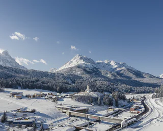
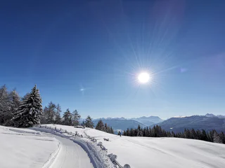
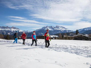
Südtirol Guide App Logo
Přeskočit na obsah

přidáno k oblíbeným

odebráno z oblíbených

Jejda! Došlo k problému, zkuste to prosím znovu

Vytváří se váš účet

Váš účet byl úspěšně vytvořen a nyní jste přihlášeni

Jste úspěšně přihlášeni!

Váš účet byl úspěšně vytvořen, ale nepodařilo se nám vás automaticky přihlásit

Jste odhlášeni

Filtr
Vybrané filtry
    Úroveň obtížnosti
    Doba trvání
    Vzdálenost v km
    Aktivity

    Zimní turistika v Jižním Tyrolsku

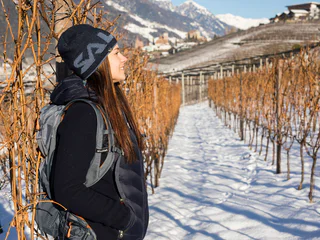
    Během zimních túr po upravených stezkách poznáte klidnou stránku Jižního Tyrolska. Objevte okouzlující vyhlídky v Dolomitech, zasněžené lesy v tichých bočních údolích a vychutnejte si přírodu na vlastní pěst v absolutním tichu. Na sněžnicích se vydáte daleko od sjezdovek a lanovek do nedotčených lesů. Tak se turistika na sněžnicích a zimní turistika stává skutečným zážitkem.

    Výsledky
    Hiking
    Winter hiking tour - Untergasse - Lärcha/Larici - NIederdorf/Villabassa
    Niederdorf/Villabassa, Dolomites Region 3 Zinnen

    Very easy walk on the "Kirchweg" path with a view over the Pustertal valley.
    Starting point: Säge/Segheria (1206 m)

    Please note: Due to the temperature fluctuations, there may be icy patches on the trails and we therefore recommend the use of crampons!


    Obtížnost: nízká
    48 m nadmořská výška
    1h:03 min doba trvání
    Hiking
    Knottnkino in Vöran - Short hike from Eggerhof
    Vöran/Verano, Meran/Merano and environs

    The Knottnkino is a lookout point. It's outfitted with thirty cinema seats, where the hikers can take a seat and enjoy the unique experience: nature as cinema. The site overlooks the whole of the Adige Valley so visitors enjoy stunning views that encompass the Texel Mountains, Mount Penegal, and even Weißhorn farther afield.


    Obtížnost: nízká
    190 m nadmořská výška
    0h:45 min doba trvání
    Summer
    Winter hike: Panoramic hike in the Val Casies/Gsiesertal Valley
    Gsies/Valle di Casies

    Short hike at the head of the valley

    Starting point: Val Casies/Gsiesertal Valley – S. Maddalena, Head of the valley (1465 m)
    Distance: 2 km
    Descent: circular hike
    Walking time: 00:40 h
    Difficulty: easy
    Difference in altitude: 80 m
    Tobboganing possibility: no

    Obtížnost: nízká
    73 m nadmořská výška
    0h:34 min doba trvání
    Hiking
    Knottnkino in Vöran - start at the bus stop Alpenrose
    Burgstall/Postal, Meran/Merano and environs

    The Knottnkino is a lookout point. It's outfitted with thirty cinema seats, where the hikers can take a seat and enjoy the unique experience: nature as cinema. The site overlooks the whole of the Adige Valley so visitors enjoy stunning views that encompass the Texel Mountains, Mount Penegal, and even Weißhorn farther afield.

    Obtížnost: nízká
    187 m nadmořská výška
    0h:40 min doba trvání
    Hiking
    "Feuersteig" Schlanders - Vetzaner Leiten
    Schlanders/Silandro, Vinschgau/Val Venosta

    This trail is mostly snow-free and offers a magnificent view of the opposite Monte Tramontana mountains with the Stelvio National Park and the snowy Ortler group.

    Obtížnost: střední
    348 m nadmořská výška
    2h:37 min doba trvání
    Hiking
    Winter Hike: Moos - Kreuzbergpass
    Sexten/Sesto, Dolomites Region 3 Zinnen

    It is a very fine and enjoyable hike for everyone - easy, practical and very beautiful, but the best thing is the view!!!

    Obtížnost: střední
    649 m nadmořská výška
    4h:04 min doba trvání
    Summer
    Winter hike: Passing by historic farmsteads and farmhouses
    Gsies/Valle di Casies

    Circular hike to the head of the valley in the Val Casies/Gsiesertal Valley 

    Starting Point: Val Casies/Gsiesertal Valley – S. Maddalena, Head of the valley, Parish church (1400 m)
    Distance: 6 km
    Descent: circular hike
    Walking time: 01:50 h
    Difficulty: medium
    Difference in altitude: 175 m
    Information: Depending on weather conditions: with freshly fallen snow only accessible with snow shoes.

    Obtížnost: nízká
    222 m nadmořská výška
    1h:43 min doba trvání
    Hiking
    Winter hiking along Ried, Lettner, Waldbrunn and Gailerhof in Monguelfo
    Welsberg-Taisten/Monguelfo-Tesido

    A hike along Ried, Lettner, Waldbrunn and Gailerhof and back to Welsberg

    Starting point: Monguelfo-Tesido – Monguelfo, bus stop in the Via Stazione 1087 m
    Distance: round hike of ca. 5 km
    Hiking time: 2 hours
    Level of difficulty: medium to difficult
    Altitude difference: 144 m

    Obtížnost: střední
    144 m nadmořská výška
    2h:00 min doba trvání
    Hiking
    Hike to Rastlhof Farm
    Schenna/Scena, Meran/Merano and environs
    Panoramic family hike on the Schennaberg to the Rastlhof Farm. Rastlhof Farm is a paradise for animals alike: cats, ponies, a Bernese mountain dog and Highland cattle live on this farm!
    Obtížnost: nízká
    220 m nadmořská výška
    1h:30 min doba trvání
    Summer
    Monte S. Vigilio/Vigiljoch to Colle Scabro/Rauher Bühel
    Tscherms/Cermes, Meran/Merano and environs

    Take the cable car and the chair lift up. About sunny plateaus teaseling Bühel on Vigiljoch. The road (Mark. 4) leads slightly downhill to the west, crosses the path of a small ski lift and leads between the inn and the church of St. Jocher.

    From there you follow the markings 9-30 in moderate ascents through the forests to the south and southwest. From a large clearing, which can be reached on the southern edge, suddenly the rough Bühel is right diagonally forward to identify on which (unfortunately) are an antenna system and a hunter high level. The direct descent to Naturnser Alm is possible, but more difficult. The short descent back to the gate and the circumnavigation is also the next hilltop, where you a beautifully located plateau crossed by the north (Mark. 9B) and short to Naturnser Alm (no winter) descends.

    From Naturnser Alm it's off to Mark. 30 in the north-east mainly through forest back to San Vigilio.

    Obtížnost: střední
    217 m nadmořská výška
    3h:30 min doba trvání
    Hiking
    Knottnkino hike from Vöran
    Vöran/Verano, Meran/Merano and environs

    The Knottnkino (Knott meaning rock, kino meaning cinema) is one of the most beautiful viewpoints in Vöran/Verano and is located upon the Rotstein Knott mountain. In the seats made from steel and chestnut wood designed and positioned by the artist Franz Messner from Ritten/Renon, one can enjoy unique views of the Texelgrupperange all the way to Penegal mountain and the Weißhorn peak, as though sitting comfortably in a cinema. But the film is always changing in the Knottnkino: daily, hourly, with the time of day and the changing of the season, with the climate and weather, there is always something new to see...

    Obtížnost: střední
    300 m nadmořská výška
    2h:15 min doba trvání
    Snowshoe Hikes
    Premium Panorama Tour on the Rittner Horn Mountain
    Ritten/Renon, Bolzano/Bozen and environs

    Italy’s first premium winter trail is located on the Rittner Horn mountain. Along the trail, especially during the descent from the Rittner Horn peak to the Unterhorn inn, you can enjoy panoramic views of the fascinating Dolomites, a UNESCO World Heritage Site.

    Route: the winter hike begins at the mountain station of the Bergbahn Rittner Horn cable car on the Schwarzseespitze peak. Pass by the Runder Tisch viewpoint and the “Dolomitoskop” on the panoramic trail no. 19 to the Unterhorn inn. Bear left at the Feltuner Hütte mountain hut and continue following the markers up to the Rittner Horn, the highest point. Head via the Alpine pastures down to the Unterhornhaus inn and to the Schwarzenseespitze.

    An alternative route for families with children: take only the smaller circular route along the panoramic trail. Walking time: approx 1 hour.

    Tip: The easy way to get from Bolzano/Bozen to Soprabolzano/Oberbozen is on the Rittner Seilbahn cable car. Continue on the narrow-gauge railway to Collalbo/Klobenstein. Finally take bus 166 to the valley station of the Bergbahn Rittner Horn cable car.

    Obtížnost: střední
    355 m nadmořská výška
    2h:47 min doba trvání
    Hiking
    Winter hike: The Kradorfer Alm hut in the Val Casies/Gsiesertal Valley 1704 m
    Gsies/Valle di Casies

    Hiking fun for all ages

    Starting point: Val Casies/Gsiesertal Valley – S. Maddalena, Head of the valley (1465 m)
    Distance: 3,5 km
    Descent: along the ascending route
    Walking time: 01:10 h
    Difficulty: easy
    Difference in altitude: 239 m
    Tobogganing possibility: yes / easy difficulty
    Information: also feasible with snowshoes or touring skis

    Obtížnost: nízká
    239 m nadmořská výška
    1h:00 min doba trvání
    Hiking
    Meditation walk for families in Vöran
    Vöran/Verano, Meran/Merano and environs

    The eight stations designed by Oswald Kröss will accompany you and will touch important values of your life.

    Obtížnost: nízká
    18 m nadmořská výška
    0h:25 min doba trvání
    Hiking
    Winter hike: The Moos Alm hut in the Val Casies/Gsiesertal Valley 1477 m
    Gsies/Valle di Casies

    For winterlovers

    Starting point: Val Casies/Gsiesertal Valley – S. Maddalena, Head of the valley (1465 m)
    Distance: 0,5 km
    Descent: along the ascending route
    Walking time: 00:10 h
    Difficulty: easy
    Difference in altitude: 12m
    Tobogganing possibility: no
    Information: Directly at the cross country track

    Obtížnost: nízká
    11 m nadmořská výška
    0h:12 min doba trvání
    Summer
    Winter hike: The Messnerhütte hut in the Val Casies/Gsiesertal Valley 1660 m
    Gsies/Valle di Casies

    Family friendly hike

    Starting point: Val Casies/Gsiesertal Valley – S. Maddalena, Head of the valley (1465 m)
    Distance: 3 km
    Descent: along the ascending route
    Walking time: 01:00 h
    Difficulty: easy
    Difference in altitude: 195 m
    Tobogganing possibility: yes / easy difficulty
    Information: also feasible with snowshoes or touring skis

    Obtížnost: nízká
    200 m nadmořská výška
    0h:49 min doba trvání
    Hiking
    From Tall to Hiaslbauer Mountain Inn
    Schenna/Scena, Meran/Merano and environs
    An easy family hike to the Hiaslbauer Mountain Inn in the idyllic mountain hamlet of Videgg. Videgg is an old hamlet at an altitude of 1,500 meters. This charming hamlet consists of a little church, mountain inns and a few farms.
    Obtížnost: nízká
    190 m nadmořská výška
    2h:00 min doba trvání
    Hiking
    Winter walking tour - Braies Vecchia/ Altprags
    Prags/Braies, Dolomites Region 3 Zinnen

    Pleasant hike along the bright side of the Altpragsertal valley.

     Starting point: Untergasse(1140m)                                                                                                    
     Arrival point: Brückele/Ponticello (1491 m)

    Please note: Due to the temperature fluctuations, there may be icy patches on the trails and we therefore recommend the use of crampons!

    Obtížnost: nízká
    373 m nadmořská výška
    2h:25 min doba trvání
    Hiking
    Vallunga/Langental Winter Walk
    Sëlva/Selva di Val Gardena, Dolomites Region Val Gardena

    The Vallunga is the entrance to the Naturepark Puez - Odle. It lasts a few km and it's in the middle of woods and mountains. The valley has a flair of quiteness and calm and everybody can enjoy it during a walk in the valley.

    Obtížnost: nízká
    0 m nadmořská výška
    2h:00 min doba trvání
    Summer
    Mount Vigiljoch - St. Vigilius church - Naturnser Alm
    Tscherms/Cermes, Meran/Merano and environs
    Family hike starting at the Vigiljoch mountain station, from where numerous hiking trails lead to unique places such as the St. Vigilius church. This hike is particularly beautiful in autumn, when larches and blueberry bushes glow brightly.
    Obtížnost: nízká
    410 m nadmořská výška
    3h:00 min doba trvání
    Hiking
    Winter hike: To the Gallfallalm huts 1667m in the Val Casies/Gsiesertal Valley
    Gsies/Valle di Casies

    Hike from S. Martino to the Karbacher Tal Valley

    Starting point: Val Casies/Gsiesertal Valley – S. Martino, tourist information office (1276 m) or Karbacherhof farm (1425 m)
    Distance: 5 km
    Descent: same way as ascent
    Walking time: 01:50 h
    Difficulty: medium
    Difference in altitude: 391 m S. Martino | 242 m maso Karbacherhof
    Tobogganing possibility: no
    Information: Depending on weather conditions: with freshly fallen snow in parts only accessible with snow shoes.

    Obtížnost: nízká
    230 m nadmořská výška
    1h:30 min doba trvání
    Summer
    Winter hike: Short hike at the Ackerle in the Val Casies/Gsiesertal Valley

    An afternoon hike

    Starting point: Val Casies/Gsiesertal Valley – S. Maddalena, Head of the valley (1465 m)
    Distance: 2,5 km
    Descent: circular hike
    WalkingTime: 00:50 h
    Difficulty: easy
    Difference in altitude: 102 m
    Tobboganing possibility: no
    Information: Depending on weather conditions: partially only accessible with snow shoes.

    Obtížnost: nízká
    104 m nadmořská výška
    0h:43 min doba trvání
    Hiking
    Circular Hike: Kalterer See Lake
    Kaltern an der Weinstraße/Caldaro sulla Strada del Vino, Alto Adige Wine Road

    Route: from the car park at Kalterer See lake, continue north to the Geier restaurant. Behind the restaurant, a narrow trail leads to the north into the orchards. Walk along these and turn off to the right in an easterly direction following the markers. At the slope on the eastern side of the valley, turn right, passing by the hotel on the left to the Klughammer road. First follow this road, then continue on a trail above the road.

    This trail ends at the southern end of the lake. Cross the road to join the Nature Discovery Trail (Naturerlebnisweg). At the end of this nature trail, turn right onto the so-called Kuchlweg trail, hiking to the vineyards on the western side of the valley. Just before the wine road, turn right into the trail through the field, following it until you reach the point where the wine road curves to the right. Cross over and now follow a trail through the field once more. Then follow the footpath next to the wine road to the church of San Giuseppe al Lago/St. Josef am See (Kirche St. Josef). Take the farm track to the right back to the starting point of the hike.

    Obtížnost: nízká
    0 m nadmořská výška
    2h:00 min doba trvání
    Summer
    Winter hike: Along the “Talblickweg” path in the Val Casies/Gsiesertal Valley
    Gsies/Valle di Casies

    The panoramic street of the Val Casies Valley

    Starting point: Val Casies/Gsiesertal Valley – S. Maddalena, Head of the valley (1465 m)
    Distance: 16,5 km
    Descent: using public transport
    Walking time: 05:00 h
    Difficulty: easy
    Difference in altitude: 200 m
    Tobboganing possibility: no
    Information: Depending on weather conditions: with freshly fallen snow only accessible with snow shoes.

    Obtížnost: nízká
    268 m nadmořská výška
    4h:28 min doba trvání
    Hiking
    Winter hike: The Taistner Alm hut in Tesido 2012 m
    Welsberg-Taisten/Monguelfo-Tesido

    A well-known hut with a beautiful view

    Starting point: Monguelfo-Tesido – Tesido, parking lot above the mountain farm Mudler (1620 m)
    Distance: 4,1 km
    Descent: along the ascending route
    Walking time: 01:30 h
    Difficulty: easy
    Difference in altitude: 392m
    Tobogganing possibility: yes / difficulty easy
    Information: also feasible with snow shoes or touring skis

    Obtížnost: střední
    420 m nadmořská výška
    1h:30 min doba trvání
    Hiking
    Winter hiking - Brückele/Ponticello - Plätzwiese high plateau
    Prags/Braies, Dolomites Region 3 Zinnen

    This hike leads to one of the most beautiful high plateaus in South Tyrol in the heart of the Fanes-Sennes-Braies nature park, which is a UNESCO World Heritage Site. Plätzwiese high plateau fascinates with an overwhelming view of the surrounding mountains of the Dolomites. Dominating everything is the northernmost 3000 metre peak in the Dolomites - the Hohe Gaisl (3146m).

    Please note: Due to the temperature fluctuations, there may be icy patches on the trails and we therefore recommend the use of crampons!


    Obtížnost: střední
    561 m nadmořská výška
    2h:17 min doba trvání
    Hiking
    Winter hiking: The Aschtalm hut in the Val Casies/Gsiesertal Valley 1950 m
    Gsies/Valle di Casies

    Hiking and sledding fun at “Hubi”

    Starting point: a) Val Casies/Gsiesertal Valley – S. Maddalena, Head of the valley (1465 m) b) Val Casies/Gsiesertal Valley – S. Maddalena, “Huben” cottages
    Distance: a) 3,3 km b) 3,8 km
    Descent: along the ascending route
    Walking time: a) 01:30 - 02:00 h b) 01:15 h – 01:30 h
    Difficulty: a) medium b) easy
    Difference in altitude: a) 485 m b) 410 m
    Tobboganing possibility: yes / medium difficulty
    Information: also feasible with snowshoes or touring skis | Tip: Snowshoe hike from Calsale "Huben (limited parking available) along Pfinn stream possible (01:00 h)

    Obtížnost: nízká
    485 m nadmořská výška
    1h:15 min doba trvání
    Hiking
    Winter hike: The Uwald Alm hut in the Val Casies/Gsiesertal Valley 2042 m
    Gsies/Valle di Casies

    Where you get the most beautiful view of the valley

    Starting point: Val Casies/Gsiesertal Valley – S. Maddalena, Head of the valley (1465 m)
    Distance: 5 km
    Descent: along the ascending route
    Walking time: 01:30 – 02:00 h
    Difficulty: medium
    Difference in altitude: 577 m
    Tobboganing possibility: yes
    Information: also feasible with snowshoes or touring skis  

    Obtížnost: střední
    577 m nadmořská výška
    2h:00 min doba trvání
    1 2 3 4 5 6 7 8 9 10 11 12 13 14 15