Přeskočit na obsah

přidáno k oblíbeným

odebráno z oblíbených

Jejda! Došlo k problému, zkuste to prosím znovu

Vytváří se váš účet

Váš účet byl úspěšně vytvořen a nyní jste přihlášeni

Jste úspěšně přihlášeni!

Váš účet byl úspěšně vytvořen, ale nepodařilo se nám vás automaticky přihlásit

Jste odhlášeni

Filtr
Úroveň obtížnosti
Doba trvání
Vzdálenost v km

Objevte krásy Dolomiti Kronplatz

Kronplatz vás okouzlí svou krásou a širokými možnostmi pro lyžování a zimní sporty.
Výsledky
Leisure & Experience
Jogging Biotope "Rasner Möser"
Rasen-Antholz/Rasun Anterselva, Dolomites Region Kronplatz/Plan de Corones

From the culture house in Rasun di Sopra enter in the Biotope "Rasner Möser". Continue through the biotope to the Walder farm until reaching the fish pond in Anterselva do Sotto. Along the river back to Rasun di Sopra.

Obtížnost: střední
60 m nadmořská výška
2h:45 min doba trvání
Summer
Panoramic trail Pfalzen / Falzes
Pfalzen/Falzes, Dolomites Region Kronplatz/Plan de Corones
This pleasant hike above Pfalzen leads through meadows and along the edge of the forest, passes wayside crosses, chapels and farms and offers a beautiful view on the village and the Kronplatz.
Obtížnost: nízká
189 m nadmořská výška
2h:00 min doba trvání
Mountaineering
Alpine tour on the summit of the Rammelstein/Monte Montone
Percha/Perca, Dolomites Region Kronplatz/Plan de Corones

Nice mountain hike with great views over the Puster Valley and the mountains of the Rieserferner-Ahrn nature park. Suitable only for trained hikers, sure-footedness is required.

Obtížnost: vysoká
1111 m nadmořská výška
3h:30 min doba trvání
Leisure & Experience
Nordic Walking Niederrasen - Neunhäusern
Rasen-Antholz/Rasun Anterselva, Dolomites Region Kronplatz/Plan de Corones

Upon leaving the Recreation Park in Rasun di Sotto, cross the bridge, turn left, and preceed along the brook to the main road. From here, proceed towards Camping Corones and then pass under and across the main road, continue along Novecase until you reach the Bridge at Valdaora di Sotto, and then turn left and proceed towards Valdaora di Sotto, connecting to the Routes at Olang.

Obtížnost: nízká
30 m nadmořská výška
1h:30 min doba trvání
Lifts
Olang 1
Olang/Valdaora, Dolomites Region Kronplatz/Plan de Corones

In the winter season 2021/22 the new cable car Olang 1+2 will be open for skiers for the first time. 

With a speed of 6.5m/s and a transport capacity of 3,900 persons per hour, the new lift is the ascent system with the highest transport capacity at Kronplatz/Plan de Corones.  

With the architectural masterpiece of Dip-Ing. Cornelius Schlotthauer (former Senior Associate at Zaha Hadid Architects) and the modern lift technology of Doppelmayr Italia, the Olang 1+2 lift system is the new highlight on the No. 1 ski mountain in South Tyrol.

The new cable car is not only the fastest and most innovative, but also one of the most comfortable lifts leading directly from the valley to the summit.

Obtížnost: nízká
0 m nadmořská výška
0h:09 min doba trvání
Summer
Family hike in the kids world
Olang/Valdaora, Dolomites Region Kronplatz/Plan de Corones

The playground situated in close proximity to nature stretches out over several hundred meters and invites the whole family to test their abilities in the forest playground with its water world and climbing area. Whilst enjoying this, the children breathe the fresh, healthy forest air while simultaneously refreshing and strengthening their brain, their whole being in fact, with oxygen. The play trail is mostly accessible with a pushchair. It is ideal as a place to go for a stroll or longer walk, a stop off point on a day trip to the Pusteria Valley, Lake Braies/Prags or the panoramic walk at Plan de Corones. Starting point is the elementary school in Valdaora di Sopra (street Aue 16), from there crossing the bridge, in about 5 minutes you can reach easily the Kids World.

Obtížnost: nízká
33 m nadmořská výška
0h:07 min doba trvání
Summer
Nössler path
Rasen-Antholz/Rasun Anterselva, Dolomites Region Kronplatz/Plan de Corones

From Antholz Niedertal > path n. 15 to the Dörfl > Nösslerhof > Berghotel Johanneshof > and back on the main road to the starting point. 

Obtížnost: nízká
173 m nadmořská výška
1h:15 min doba trvání
Slopes
Erta
Al Plan/San Vigilio, Dolomites Region Kronplatz/Plan de Corones

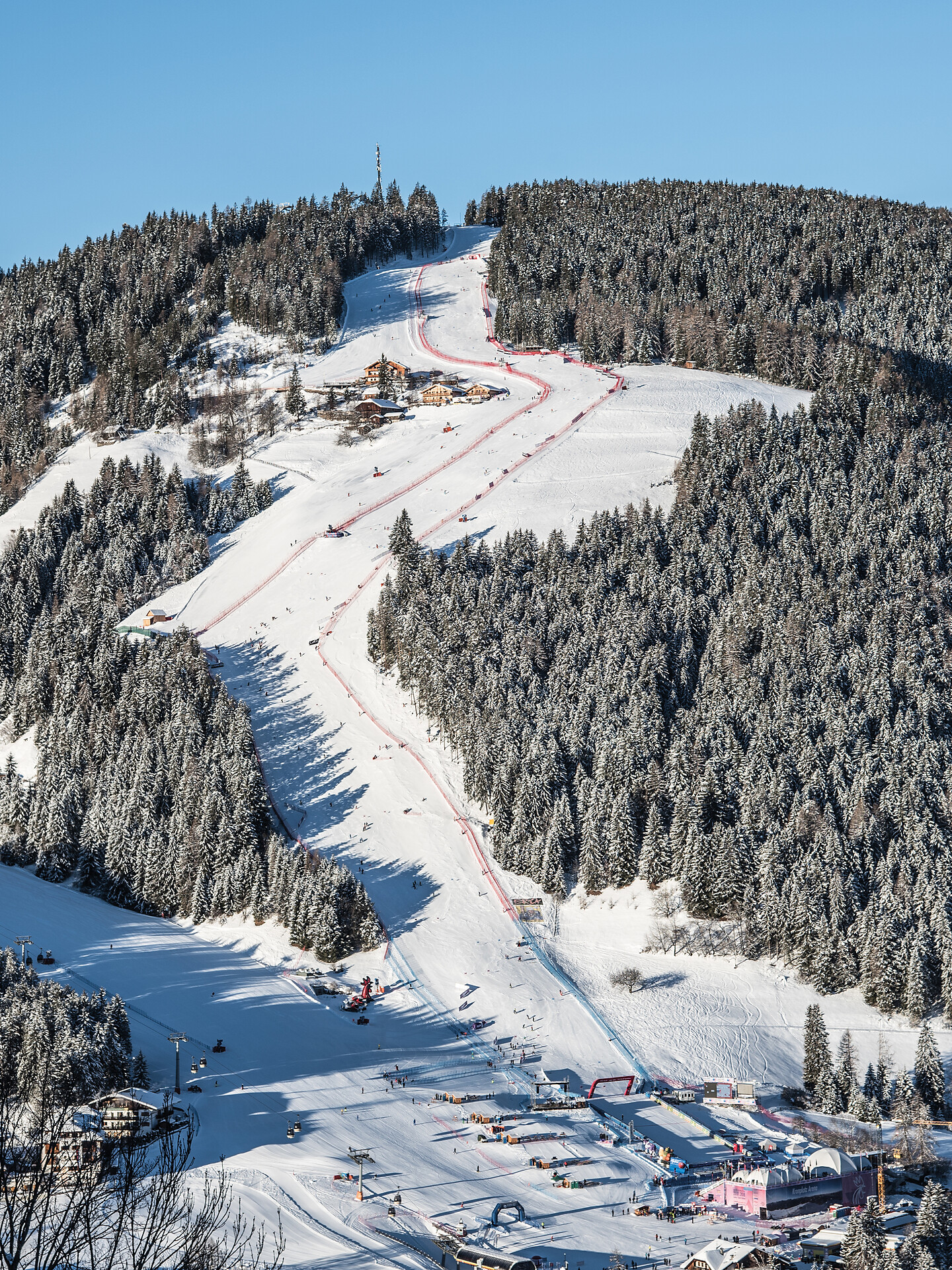
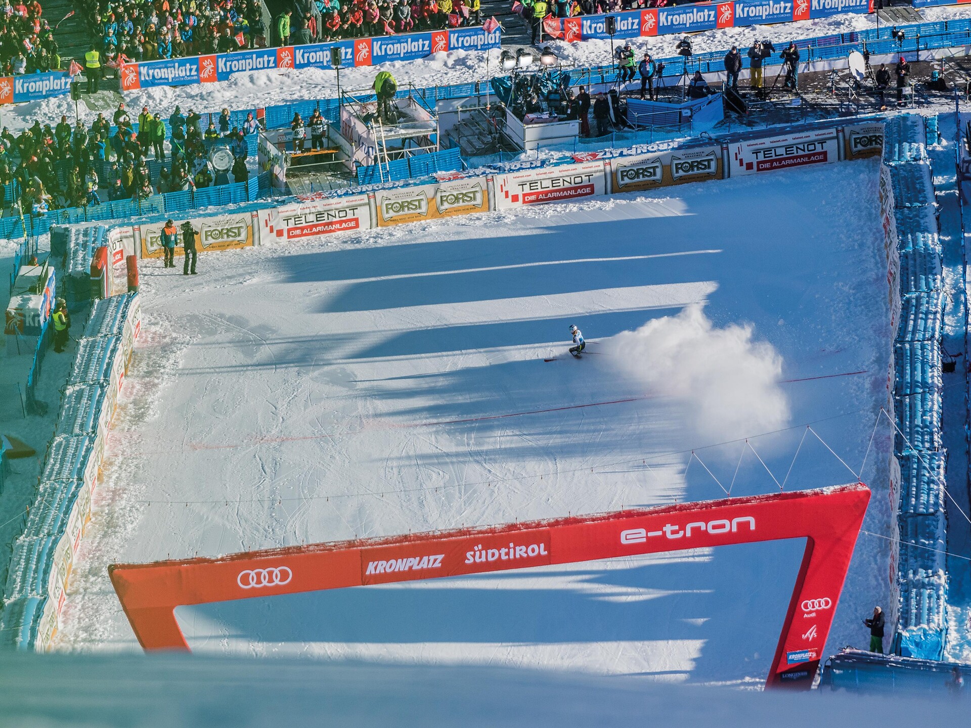
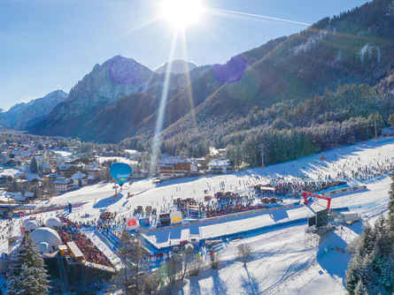
With their key figures, the "ERTA" can be quite impressive and does not need to fear comparisons with other prestigious racing circuits. The start is at 1.605 m above sea level on the Piz de Plaies and is served by the same named cable car. The goal, on the other hand, is 1.200 m on the "Pedagà" slope and thus has a height difference of 405 m with a length of 1.325 m.

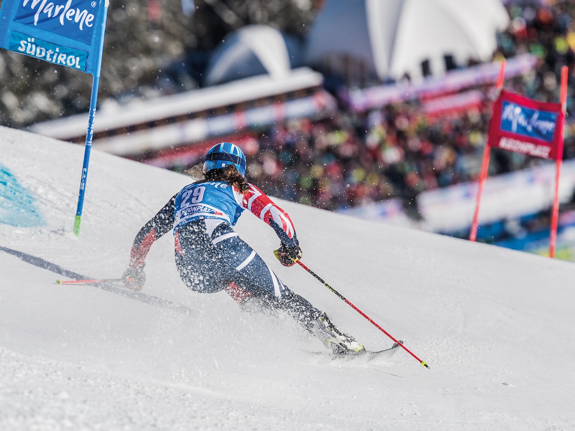
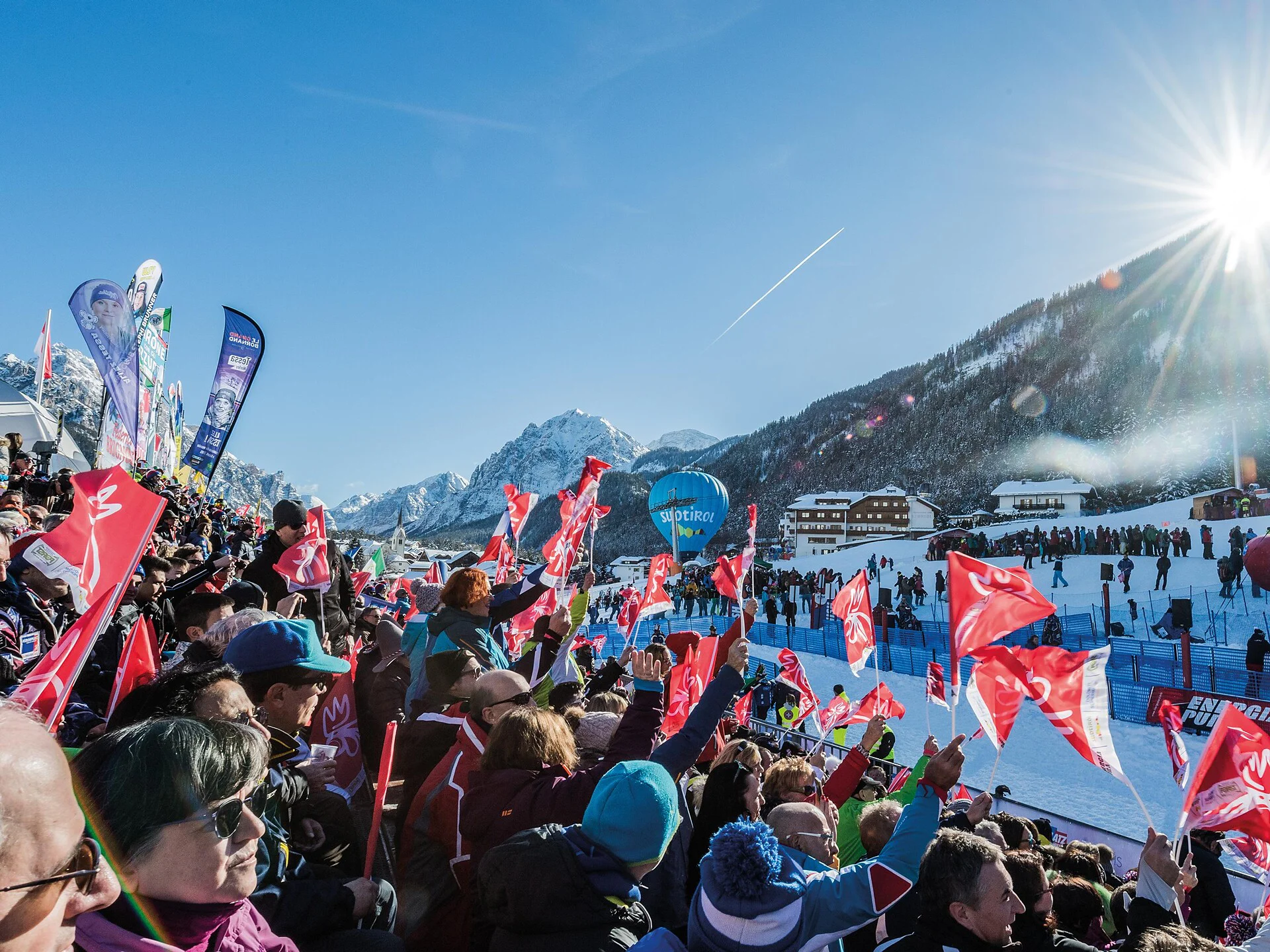
Also impressive is the slope, with an average of 32% with a lowest inclination of 22% and a maximum inclination of 61% on the "Gran Para" slope in the middle part of the track. On the "ERTA" track, which was built in 2003 on the initiative of winter pioneer Erich Kastlunger, has hosted some editions of the FIS European Cup, both GS and SL. Among others, Marcel Hirscher (AUT), Marcus Sandell (FIN), Alexander Ploner (ITA), Florian Eisath (ITA) and Kalle Palander (FIN) were the winners.

Obtížnost: vysoká
0 m nadmořská výška
0h:07 min doba trvání
Summer
Panoramic walking tour: Niederrasen - Redensberg - Raut
Rasen-Antholz/Rasun Anterselva, Dolomites Region Kronplatz/Plan de Corones

From Niederrasen > Pfaffingerhöfe > Burgfriedenhof > path n. 4 > Redensberg > mark n. 22 > "Schweinberg" > Rauterhöfe > descent on path n. 8 to Niederrasen or following mark n. 22 to Neunhäusern > Camping Corones > Niederrasen.

Obtížnost: střední
426 m nadmořská výška
3h:00 min doba trvání
Summer
Monghezzo/Getzenberg mountain farm hike
Kiens/Chienes, Dolomites Region Kronplatz/Plan de Corones

Traditions and a glimpse of times long gone

The mountain farmsteads on the southern hillside of the Pusteria/Pustertal valley are a remnant of the times when the Romans began to settle in the area. Only a little is left of the ancient baths of Ilistra/Ilstern, to which the locals once flocked in search of the soothing medicinal effect of their spa waters. Not far off, a small chapel has successfully defied the centuries and can easily be reached on a meditation trail. But hiking along Monghezzo/Getzenberg also offers plenty of impressions of the hard life and labor of mountain farmers, and the ancient farmhouses are often named after the dwellers' special dedication: The Vögler farmstead, for example, recalls the old Tyrolean tradition of fowling, or bird-catching.
Half-way up the route at 1112 m, the Jausenstation Hoferhof inn is a fine place for a break and some refreshments. A small, carefully restored chapel is all that is left of a hermitage, which is said to have been located not far from the Getzenbergerhof inn. The Kustoler-Hof farmstead was named after the Romance term for a fortified area, and the Roman milestone on the western edge of the hamlet Casteldarne/Ehrenburg is yet another witness of the ancient settlements in and around Chienes/Kiens.

Obtížnost: střední
600 m nadmořská výška
4h:30 min doba trvání
Summer
Niederrasen - Jagdhaus - Oberrasen
Rasen-Antholz/Rasun Anterselva, Dolomites Region Kronplatz/Plan de Corones

From Niederrasen (Pfaffingerhöfe) > following the edge of the woods (Dorfrundweg) > Jagdhaus > on the asphaltic road (mark n. 3) down to Oberrasen > back to Niederrasen along the river.

Obtížnost: nízká
166 m nadmořská výška
1h:00 min doba trvání
Summer
Hiking Trail Via Artis
Bruneck/Brunico, Dolomites Region Kronplatz/Plan de Corones
Situated at an altitude of 2,275 metres, the Via Artis is the highest located open-air art gallery in the world! This 6 km circular trail features 6 works of local artists which you can enjoy alongside the impressive backdrop of the Dolomites and the main Alpine divide. As they are crafted out ofthe damaged wood caused by storm Vaja in 2018 as well as the massive snow load damages in 2019, the exhibited artworks represent a further contribute to our endeavours towards a more sustainable future. Moreover, at its three access points, the Via Artis provides you with interesting insights into three topics of major importance for the Kronplatz/Plan de Corones: the Kronplatz military trail, protection of our flora, our alpine pastures in between tradition, tourism and economy.

Easy, three-hour hike around the top of Mount Kronplatz, suitable for all hiking levels.

Obtížnost: střední
270 m nadmořská výška
3h:00 min doba trvání
Leisure & Experience
Nordic Walking Rasen
Rasen-Antholz/Rasun Anterselva, Dolomites Region Kronplatz/Plan de Corones
From the Recreation Park in Rasun di Sotto through the heart of the village to the curch. From there, take the hiking trail up to the Oberstall Estates. Descend via the road towards Rasun di Sopra to the "House of Culture". Retur via the Mühl Valley towards Rasun di Sotto.
Obtížnost: nízká
238 m nadmořská výška
2h:30 min doba trvání
Summer
Niederolang - Gassl - Bad Bergfall
Olang/Valdaora, Dolomites Region Kronplatz/Plan de Corones

This varied hike begins in Lower Valdaora and follows trail no. 32B towards Bad Bergfall. The well-marked path winds through peaceful forest sections and offers lovely views of the surrounding mountains. It's a great choice for warm days, as much of the route is shaded and pleasantly cool. The destination is Bad Bergfall, known for its sulfur springs.

Obtížnost: nízká
318 m nadmořská výška
1h:37 min doba trvání
Leisure & Experience
Nordic Walking Oberstall
Rasen-Antholz/Rasun Anterselva, Dolomites Region Kronplatz/Plan de Corones

From the Recreation Park in Rasun di Sotto through the heart of the village to the curch. From there, take the hiking trail up to the Oberstall Estates. Descend via the road towards Rasun di Sopra to the "House of Culture". Retur via the Mühl Valley towards Rasun di Sotto.

Obtížnost: nízká
180 m nadmořská výška
1h:30 min doba trvání
Summer
Pfalzen / Falzes – Irenberg
Pfalzen/Falzes, Dolomites Region Kronplatz/Plan de Corones
Easy walk, suitable for families - in summer also with stroller - from the sports area in Pfalzen/Falzes to Irenberg.
Obtížnost: nízká
126 m nadmořská výška
2h:00 min doba trvání
Leisure & Experience
Jogging: Oberstall
Rasen-Antholz/Rasun Anterselva, Dolomites Region Kronplatz/Plan de Corones

From Rasun di Sotto you pass the church and the cemetery and you follow the street up to the farm Oberstall. Turn back on the road towards Rasun di Sopra and back to Rasun di Sotto near the river.

Obtížnost: střední
172 m nadmořská výška
1h:30 min doba trvání
Leisure & Experience
Jogging long round through Rasen
Rasen-Antholz/Rasun Anterselva, Dolomites Region Kronplatz/Plan de Corones

From Rasun di Sotto to the Camping Corones. Here turn right and continue on the path "Dorfrunde" to the hunting hut. Follow the path until you reach the Barbecue in Rasun di Sopra. Cross the main street and along the river turn back to Rasun di Sopra and Rasun di Sotto.

Obtížnost: střední
253 m nadmořská výška
3h:00 min doba trvání
Summer
Niederrasen - Wasserwaldile - Oberrasen - Biotope Rsner Möser
Rasen-Antholz/Rasun Anterselva, Dolomites Region Kronplatz/Plan de Corones
From the tourist office Niederrasen you can walk towards Oberrasen through the water adventure park, where you will find playgrounds for children based on the element water. Continue to Oberrasen and then follow the signs to the biotope "Rasner Möser". You can either take the same path or follow the Antholz stream back to Niederrasen. The hike can then be concluded with a Kneipp tour at the Niederrasen leisure park.
Obtížnost: nízká
116 m nadmořská výška
2h:22 min doba trvání
Leisure & Experience
Nordic Walking Redensberg
Rasen-Antholz/Rasun Anterselva, Dolomites Region Kronplatz/Plan de Corones

From Rasun di Sotto towards the Camping Corones and continue via the "Dorfrunde" hiking trail to a crossroad. Follow the street to Redensberg and on the hiking trail in direction Mount Hochnall. Go down to the farm Burgfrieden and descend to the hunting hut. Continue to the left following the "Dorfrunde" hiking trail until you reach the Barbecue in Rasun di Sopra. Cross the main street and go back along the river to Rasun di Sopra or Rasun di Sotto.

Obtížnost: vysoká
539 m nadmořská výška
3h:45 min doba trvání
Lifts
Ried
Percha/Perca, Dolomites Region Kronplatz/Plan de Corones
Obtížnost: nízká
0 m nadmořská výška
0h:18 min doba trvání
Leisure & Experience
Jogging Rasun di Sotto / Niederrasen
Rasen-Antholz/Rasun Anterselva, Dolomites Region Kronplatz/Plan de Corones

From Niederrasen in the middle of the wood to the Camping Corones and ahead to zhe Historic Bridge. There you turn right to the industrial zone and passing the Antonius Church to the soccer field in Niederrasen.

Obtížnost: střední
49 m nadmořská výška
1h:00 min doba trvání
Summer
Round of Pütia
San Martin /San Martino, Dolomites Region Kronplatz/Plan de Corones

ROUND OF PÜTIA (total walking time: 4 hours)
From Passo delle Erbe, this hike along trail 8a runs though stunning pastures. At the foot of the north face of Pütia, turn right at the fork and take trail no. 4 to the Forcella di Pütia pass. At Forcella di Putia, head south down to the Göma pass across the pastures and then on to the north face of Sasso Putia and back.

Obtížnost: střední
642 m nadmořská výška
4h:01 min doba trvání
Summer
Niederrasen - Neunhäusern
Olang/Valdaora, Dolomites Region Kronplatz/Plan de Corones

From Niederrasen > Camping Corones > foresty road in the woods > Neunhäusern.

Caution: use the path under the bridge of the statal road.

Obtížnost: nízká
26 m nadmořská výška
0h:45 min doba trvání
Summer
Niederrasen - Oberstall - Oberrasen
Rasen-Antholz/Rasun Anterselva, Dolomites Region Kronplatz/Plan de Corones

From Niederrasen > passing the church > continue on the asphaltic road on the edge of the woods (mark n. 20) > Oberstallerhöfe > path of return following mark n. 5 > Oberrasen. 

Obtížnost: střední
166 m nadmořská výška
1h:00 min doba trvání
Summer
Ruins Castle Altrasen
Rasen-Antholz/Rasun Anterselva, Dolomites Region Kronplatz/Plan de Corones

From Niederrasen (church) > from 500 m in direction > Oberstall (mark n. 20) > on the edge of the woods turn right > ruins of Altrasen.

Obtížnost: střední
147 m nadmořská výška
0h:30 min doba trvání
Long-Distance Hiking Paths
Dolomites World Heritage Geotrail II: from Armentarola to Pederü
Al Plan/San Vigilio, Dolomites Region Kronplatz/Plan de Corones

The seventh stage of the Dolomites World Heritage Geotrail II crosses the Fanes plateau between spectacular and imposing folds, evidence of when the Dolomites, part of the African continental margin, were moved 3000km northwards and collided with the rocks of the European margin.

The Dolomites UNESCO Geotrail consists of 10 daily stages, focussing particularly on the Dolomites’ geological history.

Obtížnost: střední
707 m nadmořská výška
5h:01 min doba trvání
Mountaineering
Rammelstein 2.483m
Rasen-Antholz/Rasun Anterselva, Dolomites Region Kronplatz/Plan de Corones
Antholz Mittertal or Antholz Niedertal (see walk to the Grentealm) > from there up to the Grente cross > Rammelstein. The way back by the same path or passing by the Laneralm (1.829 m) > following the mark n. 4b > Unterhütten (1.671 m, no rest stops) > by the alpine path back to the road to Antholz, on the opposite side of the Biotope.
Obtížnost: vysoká
1054 m nadmořská výška
3h:15 min doba trvání
Leisure & Experience
Jogging Oberrasen - Antholz Niedertal
Rasen-Antholz/Rasun Anterselva, Dolomites Region Kronplatz/Plan de Corones

Easy and flat jogging rout from Oberrasen to Antholz Niedertal along the river.

Obtížnost: nízká
36 m nadmořská výška
1h:30 min doba trvání