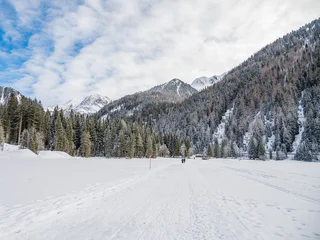
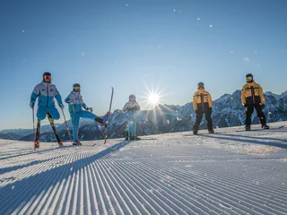
Przejdź do treści

dodano do ulubionych

usunięto z ulubionych

Coś poszło nie tak! Wystąpił problem. Spróbuj ponownie

Twoje konto jest właśnie tworzone

Twoje konto zostało pomyślnie utworzone i jesteś teraz zalogowany

Zalogowałeś się pomyślnie!

Twoje konto zostało pomyślnie utworzone, ale nie mogliśmy zalogować Cię automatycznie

Jesteś wylogowany

Filtr
Wybrane filtry
    Poziom trudności
    Czas trwania
    Odległość w km

    Kunsthandwerker in Dolomitenregion Kronplatz

    Wyniki
    Mountain bike
    To Innichen
    Rasen-Antholz/Rasun Anterselva, Dolomites Region Kronplatz/Plan de Corones

    Along the Pustertal cycling route to Innichen / San Candido.           

    Poziom trudności: łatwy
    342 wysokość w górę
    25.3 Km odległość
    Cycling
    Pustertal|Val Pusteria Bike Route: Variation San Lorenzo - Val Badia
    St.Lorenzen/San Lorenzo di Sebato, Dolomites Region Kronplatz/Plan de Corones

    This variation of the bike path continues from Brunico in the direction of S. Lorenzo|St. Lorenzen to the former Roman road station, Mansio Sebatum. Excavations and a museum offer the opportunity to learn more about the Romans in the Pustertal. The route goes from San Lorenzo to San Vigilio or to San Martin – 23 or 24 km (14.5 or 15 miles).

    Poziom trudności: łatwy
    0 wysokość w górę
    0.0 m odległość
    Mountain bike
    To the Brunst Alm Hut
    Rasen-Antholz/Rasun Anterselva, Dolomites Region Kronplatz/Plan de Corones

    From Niederrasen to Oberolang and ahead to the Brunst Alm hut (managed)

    Poziom trudności: łatwy
    1048 wysokość w górę
    10.4 Km odległość
    Mountain bike
    Langegg Alp
    Rasen-Antholz/Rasun Anterselva, Dolomites Region Kronplatz/Plan de Corones

    Antholz Niedertal > Walder Farms > Hofstattalm Hut > Langegg Hut > Antholz Niedertal.

    Poziom trudności: łatwy
    1097 wysokość w górę
    6.6 Km odległość
    Cycling
    Pustertal|Val Pusteria Bike Route: Leg San Candido|Innichen - Brunico|Bruneck
    Rasen-Antholz/Rasun Anterselva, Dolomites Region Kronplatz/Plan de Corones

    On the San Candido|Innichen to Brunico|Bruneck leg, the green color of the meadows, fields, and forests dominates the view. Along the railway route, sometimes through inhabited areas and sometimes through an undisturbed natural landscape, the bike path runs with a constant up and down from village to village as far as Brunico, the economic center of the Pustertal|Val Pusteria. 

    After the start in San Candido, the absolute first destination that is reached is the village of Dobbiaco|Toblach, the highest point of the entire leg. Following the Rienza-Rienz down the valley, the cyclist will then continue on to Villabassa|Niederdorf and Monguelfo|Welsberg. Anyone who would like to enjoy a game of golf can do so here in the newly built miniature golf course. For all culture lovers, a visit to Welsperg Castle is recommended. From Monguelfo, it is not far to Valdaora|Olang. Riders will pass by all three parts of the village, namely Valdaora di Sopra|Oberolang, Valdaora di Mezzo|Mitterolang, and Valdaora di Sotto|Niederolang, and the only problem will be too many choices as to whether there should be a detour to the Kinderwelt (“Kid’s World”) of Valdaora, a visit to the Kron Arc Adventure Park, or a trip to the restored Venetian “Lipper Säge” (Lippa Sawmill).  From Valdaora, the bike path continues downriver through undisturbed nature until the small medieval city of Brunico is reached. Towering high above the roofs of the city is Brunico Castle, while further down on the via Centrale|Stadtgasse, a lively hustle and bustle is going on in the charming shops and the many cafes, inns, and restaurants. In Brunico, there are a whole variety of museums and art treasures to experience. Of particular significance is the Folklore Museum in Teodone|Dietenheim, the Messner Mountain Museum MMM RIPA which is housed in Brunico Castle, and the newest museum, the MMM Corones. The latter is located at an elevation of 2,275 m (7,464 ft.) on the summit of the Kronplatz|Plan de Corones, and it can be reached from Riscone|Reischach by cableway.

    Possible variations along the route:

    • Valle di Casies-Gsieser Tal Bike Route from Monguelfo to Santa Maddalena-St. Magdalena – 15 km (9.5 miles)
      Experience the rural lifestyle.
    • Valle Anterselva-Antholzertal Bike Route from Rasun-Rasen to Anterselva di Mezzo-Antholz Mittertal – 13.5 km (8.5 miles) 
      On the route to one of the most beautiful high mountain lakes in South Tyrol-Südtirol.
    • Val Badia Bike Route from Brunico to San Vigilio or to San Martin – 23 or 24 km (14.5 or 15 miles)
      Getting to know the Ladin culture and language.
    • Valli di Tures and Aurina-Tauferer Ahrntal Bike Route from Brunico to S. Giacomo-St. Jakob – 36 km (22 miles)
      On two wheels through the realm of more than seventy peaks of three thousand meters (ten thousand feet).
    Poziom trudności: łatwy
    684 wysokość w górę
    34.8 Km odległość
    Cycling
    Furkelpass / Passo Furcia
    Al Plan/San Vigilio, Dolomites Region Kronplatz/Plan de Corones

    From the Antholz Valley to the Furkelpass/Passo Furcia (Altitude difference: 728 m | Lenght: 10,2 km)

    Poziom trudności: łatwy
    1373 wysokość w górę
    17.6 Km odległość
    Ski Areas
    Kronplatz ski area
    Dolomites Region Kronplatz
    The Kronplatz mountain is especially popular with demanding skiers and snowboarders. While the young practice new tricks in the two snow parks, the brave plunge down the notorious "Silvester" or "Hernegg" black slopes to Riscone/Reischach, where the après-ski bars fill up in the evenings. In the kids’ parks and ski schools, guests learn to parallel turn on the flatter slopes. Thanks to modern lifts, Bruneck’s local mountain with over 100 km of slopes is accessible from three sides. The "Piculin" lift even offers access to the "Sellaronda ski circuit", and the Ski Pustertal Express transports excited skiers to the Three Peaks Dolomites ski resort in Hochpustertal. The Plan de Corones area is an especially spacious, sunny plateau with a 360° panorama of the surrounding mountain landscape. Here, a true architectural highlight awaits discovery: at the Messner Mountain Museum "MMM Corones”, designed by star architect Zaha Hadid, mountaineering legend Reinhold Messner puts guests into dialogue with the world’s north faces, the supreme discipline of mountaineering.
    120km nachylenie stoku
    32 wyciągi
    Najwyższy punkt: 2,275 m
    Mountain bike
    Redensberg - Aschbach - Nasen
    Rasen-Antholz/Rasun Anterselva, Dolomites Region Kronplatz/Plan de Corones

    Antholz Niedertal > Redensberg > Aschbach > Nasen > Antholz Valley

    Poziom trudności: łatwy
    1121 wysokość w górę
    25.8 Km odległość
    Mountain bike
    To the Pragser Wildsee Lake
    Rasen-Antholz/Rasun Anterselva, Dolomites Region Kronplatz/Plan de Corones

    From the Antholz Valley along the Pustertal cycling route to the Pragser Wildsee lake.

    Poziom trudności: łatwy
    766 wysokość w górę
    27.1 Km odległość
    Ski Areas
    Speikboden ski area
    Ahrntal Valle Aurina, Dolomites Region Kronplatz
    Families in particular will feel at home on the gentle slopes of the Speikboden ski area in the Tauferer Ahrntal valley, where about half of the wide pistes are classified as easy. The Family fun park offers fun for young and old and the snow park gives freestylers the chance to practice their latest tricks. Long carving turns are best enjoyed next to the Sonnklar lift. The ski area’s cable cars will take you up to 2,400 m above sea level, where you can enjoy the scenery of the surrounding three thousand metre peaks either from the viewing tower or on one of the many marked snowshoe hiking trails. An overnight stay in an igloo is one of the romantic highlights of the snow-secure Speikboden ski area. Family fun is not in short supply thanks to the two toboggan runs. At ten and eight km, they are the longest toboggan runs in South Tyrol.
    38km nachylenie stoku
    8 wyciągi
    Najwyższy punkt: 2,400 m
    Mountain bike
    Bike route Antholz Valley
    Olang/Valdaora, Dolomites Region Kronplatz/Plan de Corones

    Cycling route from Neunhäusern to Antholz Mittertal                   

    Poziom trudności: łatwy
    96 wysokość w górę
    12.3 Km odległość
    Cycling
    Sellaronda
    Al Plan/San Vigilio, Dolomites Region Kronplatz/Plan de Corones

    The splendid Sellaronda route takes you round the Sella massif, offering breathtaking glimpses of the legendary Dolomites. The tour starts in San Vigilio. When you reach the centre of Corvara, turn right and take the uphill route towards Passo Gardena. After stopping to admire the Sella massif, continue on the tarmacked road to Passo Sella and from there, go uphill to the highest pass on the route, Pordoi, where a 10km descent begins, with plenty of hairpin bends, leading to the last pass on this route, Passo Campolongo. Continue for 7km to reach Corvara and then return to San Vigilio via Longega.

    Poziom trudności: średni
    2585 wysokość w górę
    106.3 Km odległość
    Mountain bike
    To Bruneck
    Bruneck/Brunico, Dolomites Region Kronplatz/Plan de Corones

    On the Pustertal cycling route from the Antholz Valley to Bruneck.

    Poziom trudności: łatwy
    54 wysokość w górę
    11.4 Km odległość
    Mountain bike
    To the view of the Three Peaks
    Toblach/Dobbiaco, Dolomites Region Kronplatz/Plan de Corones

    On the Pustertal cycling path to Toblach and ahead in direction Cortina till the View of the 3 Peaks.

    Poziom trudności: łatwy
    638 wysokość w górę
    31.6 Km odległość
    Cycling
    To Welsberg
    Welsberg-Taisten/Monguelfo-Tesido, Dolomites Region Kronplatz/Plan de Corones

    Along the Pustertal cycling route to Welsberg / Monguelfo.          

    Poziom trudności: łatwy
    254 wysokość w górę
    16.2 Km odległość
    Mountain bike
    To Niederolang and Mitterolang
    Olang/Valdaora, Dolomites Region Kronplatz/Plan de Corones

    From the Antholz Valley to Niederolang and further on to Mitterolang.

    Poziom trudności: łatwy
    172 wysokość w górę
    12.3 Km odległość
    Cycling
    Around the Kronplatz
    Rasen-Antholz/Rasun Anterselva, Dolomites Region Kronplatz/Plan de Corones

    Rasen > Olang > Furkelpass > Enneberg > Maria Saalen > Reischach > Ried > Rasen

    Poziom trudności: łatwy
    3019 wysokość w górę
    47.8 Km odległość
    Cycling
    To the Staller Saddle
    Olang/Valdaora, Dolomites Region Kronplatz/Plan de Corones

    From Niederrasen along the river to Antholz Niedertal > continue through the village Antholz Mittertal > along the main road up to the Lake Antholz > on the pass road up to the Staller Saddle.

    Poziom trudności: łatwy
    1424 wysokość w górę
    22.3 Km odległość
    Cycling
    Pustertal Valley Bike Route
    Kiens/Chienes, Dolomites Region Kronplatz/Plan de Corones

    The Pustertal Valley Bike Route is particularly suitable for bicycle tours and family cycling tours, not only for beginners but also for experts. The paved bike path starts in Rio Pusteria-Mühlbach and leads via the villages of Vandoies di Sotto-Niedervintl, Vandoies di Sopra-Obervintl, Chienes-Kiens, Casteldarne-Ehrenburg and S. Lorenzo-St. Lorenzen to Brunico-Bruneck. This first section is very flat and 25.5 km long.

    From Brunico, it takes about Perca-Percha, Valdaora di Sotto-Niederolang, Valdaora di Mezzo-Mitterolang, Valdaora di Sopra-Oberolang, Ried, Villabassa-Niederdorf and Dobbiaco-Toblach to San Candido-Innichen. This second section is again very flat, 33.5 km long, and suitable for everyone.

    The third section takes us from San Candido on Versciaco-Vierschach to Prato Drava-Winnebach where you cross the Austro-Italian border. Now follow along the Drava River to Lienz. This last subsection is 44 km long, very easy, and ideal for families. For the return, we can use the train to come back to the starting point. If the total distance is too long, you can also take only a small part of the track, and the rest you can travel by train.

    Poziom trudności: łatwy
    468 wysokość w górę
    62.3 Km odległość
    Mountain bike
    To the Lake Toblach
    Toblach/Dobbiaco, Dolomites Region Kronplatz/Plan de Corones

    Along the Pustertal valley cycling route to Toblach and ahead in direction Cortina till the lake Toblach.

    Poziom trudności: łatwy
    385 wysokość w górę
    22.4 Km odległość
    Mountain bike
    To the Lake Antholz
    Rasen-Antholz/Rasun Anterselva, Dolomites Region Kronplatz/Plan de Corones

    From Niederrasen along the river to Antholz Niedertal > continue through the village Antholz Mittertal > along the main road up to the Lake Antholz.

    Poziom trudności: łatwy
    778 wysokość w górę
    18.1 Km odległość
    Mountain bike
    To Sand in Taufers to the starting point of the Waterfalls Reinbach
    Rasen-Antholz/Rasun Anterselva, Dolomites Region Kronplatz/Plan de Corones

    On the Pustertal cycling route from the Antholz Valley to Bruneck and then in direction Ahnrtal to Sand in Taufers to the starting point of the waterfalls Reinbach. From there you can visit the waterfalls on foot.

    Poziom trudności: łatwy
    318 wysokość w górę
    33.4 Km odległość
    Cycling
    To the Biotope Rasner Möser
    Rasen-Antholz/Rasun Anterselva, Dolomites Region Kronplatz/Plan de Corones

    From Niederrasen to Oberrasen (culture house) > along the river > after approx. 1 km turn right on a country lane > further on northwards to the biotope (the moor area - an integral natural reserve with nature trail). This hike can also be started from Antholz Niedertal or Antholz Mittertal!

    Poziom trudności: łatwy
    192 wysokość w górę
    12.3 Km odległość
    Cycling
    Pustertal|Val Pusteria Bike Route: Leg Brunico|Bruneck - Fortezza|Franzensfeste
    Franzensfeste/Fortezza, Dolomites Region Kronplatz/Plan de Corones

    The Brunico|Bruneck to Fortezza|Franzensfeste leg is rich in cultural and historical treasures that make the route unique. The settlements, fortresses, and historical monuments from Roman times through the Middle Ages line the bike path along the Rienza|Rienz, offering interesting insights into the history of the valley.

    This leg of the Pustertal|Val Pusteria bike route is also hilly, as it forms the connecting point between the Central Val Pusteria and the Isarco|Eisack Valley. From Brunico, it continues in the direction of S. Lorenzo|St. Lorenzen to the former Roman road station, Mansio Sebatum. Excavations and a museum offer the opportunity to learn more about the Romans in the Pustertal. The petting zoo at Wildberg Manor is a pleasant change of pace for both young and old and not to forget the Castel Sonnenburg. Things continue on quietly through landscapes of forests and meadows toward Casteldarne|Ehrenburg (Castel Ehrenburg) and Chienes|Kiens. Those who enjoy cheese will be in for a treat at the Gatscher farmhouse cheese dairy. The trip then proceeds to S. Sigismondo|St. Sigmund and Vandoies|Vintl. At Lodenwelt, which is located there, the adventure museum devoted to the subject of loden felt can be visited, as can an animal reserve and the fine Capriz cheese dairy. Those who enjoy the finer things in life certainly won’t come up short along this route! After passing Vandoies, the bicycle trail passes by the Rio Molino|Mühlbach Gap, a former valley and road block from the twelfth century, continuing on to Rio Molino. At this point, it is possible to return by train. But for all those who have some energy and motivation left, continuing on to visit the fortress in Fortezza is certainly worthwhile.

    Possible variations along the route:

    • Val Badia Bike Route from Brunico to San Vigilio or to San Martin – 23 or 24 km (14.5 or 15 miles)
      Getting to know the Ladin culture and language.
    • Valli di Tures and Aurina|Tauferer Ahrntal Bike Route from Brunico via Campo Tures|Sand in Taufers to S. Giacomo|St. Jakob – 36 km (22 miles)
      On two wheels through the realm of more than seventy three thousand meter (ten thousand foot) peaks.
    • Bike Route Brennero-Bolzano from Fortezza|Franzensfeste toward Brennero|Brenner (45 km/28 miles) or in the direction of Bolzano|Bozen (43 km/27 miles).
    Poziom trudności: łatwy
    975 wysokość w górę
    34.8 Km odległość
    Mountain bike
    To the Kurpark in Niederdorf
    Niederdorf/Villabassa, Dolomites Region Kronplatz/Plan de Corones

    From the Antholz Valley along the Pustertal bike route to Villabassa to the Kurpark spa (playground).

    Poziom trudności: łatwy
    423 wysokość w górę
    23.4 Km odległość
    Mountain bike
    Korer Trail
    Al Plan/San Vigilio, Dolomites Region Kronplatz/Plan de Corones

    The Korer trail - a handcrafted trail master work in the valley area, which is not directly accessible by the lift. It requires full concentration, driving skills and above all, experience, and belongs to the best that mountain bikers can take under their wheels at Kronplatz.

    Length: 900 m
    Difficulty: Difficult

    Poziom trudności: łatwy
    0 wysokość w górę
    911.0 m odległość