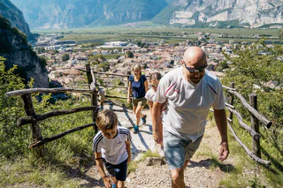
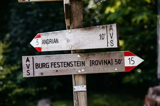
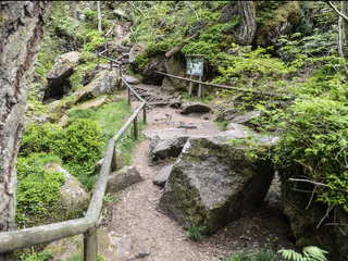
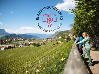
This hike leads through the Trudner Horn Nature Park, a natural jewel with diverse animal and plant life.
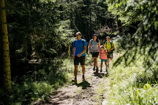
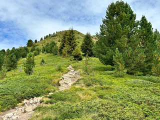
Załóż buty turystyczne i odkrywaj krajobrazy wzdłuż Południowotyrolskiej Drogi Winnej. Te wskazówki dotyczące wędrówek poprowadzą Cię krętymi ścieżkami, przez malownicze winnice i urocze wioski, aż do wietrznych panoramicznych miejsc. Od spokojnych spacerów po wymagające wycieczki - dosłownie każdy znajdzie tu coś dla siebie. Idealne połączenie obcowania z naturą i kulturą przy jednoczesnym delektowaniu się lokalnymi winami i ciepłą gościnnością charakteryzuje Południowotyrolski Szlak Winny jako region wędrówek dla koneserów.
This hike leads through the Trudner Horn Nature Park, a natural jewel with diverse animal and plant life.
Walking time: 60 - 90 minutes
Walk along the historic town center „Betlehem“, through the Gewürztraminer vineyards above Tramin-Termeno. Enjoy the Mediterranean culture, the landscape and a unique view on Tramin-Termeno and the environment.
This walk in the Monte Corno Natural Park provides you with the opportunity to admire unique landscapes and impressive mountain scenery. On a clear sunny day, you can make out the Palla Bianca, the Pennes Pass, the Mendola range of mountains and the Brenta Group.
The Pinot Noir walkway leads through the Pinot Nor growing area along the Trudner Horn/Monte Corno Nature Park and the characteristic villages of Auer/Ora, Montan/Montagna and Neumarkt/Egna. The Pinot Noir growing area in Montan and Mazon/Mazzon is one of the most famous in Italy. Furthermore you walk through several monuments and historical places. The walkway is family-friendly and not dangerous.
Along the geological path you will find a lot of signs and stations that shows the geology and the connected relations. The main attraction of the trail is the "Höllenbach" catastrophe of 1986. Following the path you will arrive on a big rock of tufa and the S. Nepomuk santuary. This rock last a violent mudslud and reminds the power of nature. The next sign reminds the mudslide of 1986. Just a short look to the panorama shows the different layers of rock from Montan to Weis and Schwarzhorn. Nearby you will find another rock. That's a Voltago conglomerate who resisted a mudslide 245 millions of years ago. After it there's the possibility to take a little break on a quiet island with 5 columns and a little bench with some small different rockets from the sourroundings. On the dam of the river a sign will explane you the different layers of the rock infront of you. The last sign indicate some fossils which where found in the river bed and with a bit of luck also you could find one.
Itinerary: A phenomenon that attracts visitors from all over South Tyrol, happens in Spring Valley between the two Laghi di Monticolo/Montiggl Lakes and Lago di Caldaro/Caldaro Lake: Yellow primrose, white daffodils, violet liverleaf, blue crocuses and primroses are stretching towards the sky - a colorful natural patchwork pleases everyone after the harsh winter days. Right in the middle there is as well the peaceful little Angel stream meandering southward. Best time to enjoy it is between mid February to late March.
From the car park the walk goes across the narrow strip of asphalt (not the main street) right down to the hamlet Monticolo/Montiggl. In the village it turns right in front of the church and follow the small asphalt street for 20 minutes through orchards and then through the forest to a crossroads. After 50 meters the Spring Valley is at the left. Going right the walk ends at Lago di Caldaro/Kaltern Lake passing through the lower part of the Spring Valley. However, on the left the walk goes up through the lovely valley following the signs to the asphalt street.
The Pichl is the starting-point for the Gfrill Village Route. From here, you continue to Unterstein and then along the cableway trail until you come to the remains of an abandoned cableway. From here, the Berger Trail will take you to the Old Gfrill Road. Continue along it until your get back to your starting-point at the Pichl.
Perdonig and Gaid are the mountain hamlets belonging to the municipality of Eppan with its otherwise mediterranean influences. Hiking here offers an excellent insight into mountain farming.
This hiking path goes through fabulous beech groves and pictorial forests.
From the main square of Penon the path follows the the trail marked nr. 7. This path follows the road - at the fork, stay left, along the forest road, then over the hiking path to Fennhals (1031 m). At the Di Pauli residence with its small church, we proceed downward over the Römerweg – marked 2 – back to Penon (605 m).
On this segment, you will proceed first from Gfrill to the bogland lakes of the "Weiss" and the "Schwarz." From there, the route continues to the Horn-Alm, the highest point of the segment. Hikers can stop here for refreshments and then continue downhill via the Ziss Saddle – not far from there, you can admire the stunning "huckete Stoan," a free-standing erratic boulder made of porphyry the size of a house – until you come to Altrei.
This alpine mountain hike in Eppan is an absolute must for vertigo- free hikers. A varied ascent through a narrow channel with a 25 metre-long (82 ft), newly installed ladder and a unique view from the summit cross.
From the village center, proceed to the sculpture garden where you can view various fascinating sculptures made of different materials. You can then continue through the splendid natural landscape until you come to the Niedere-Höfe Trail. You will pass by the Perkeo Restaurant and then through the village back to the starting-point. This is an easy stroll through the romantic natural surroundings and culture of Buchholz.
The Castelfeder hill is an ancient cultural landscape with settlement remains dating back to the Stone Age and Bronze Age. The remains of the castle complex, the legendary “slide of fertility” and the Santa Barbara chapel walls are testament to its mystical past. The area is of particular importance not only from an archaeological and historical perspective but also from an ecological point of view as for years it has enjoyed the status of being a protected natural habitat (biotope).
Hiking tour from the center of St. Michael | Eppan to the Montiggl lakes.
TIP: Go for a swim in one of the lakes and return to the starting point with the lake & hiking bus which runs from mid-June to early September.
From the main Square of Kurtatsch, the route starts up the short steep Obergasse to the little square where we turn to the right. At the next fountain the route follows Schiessstandweg for about 50 meters until the forest path marked 5a branches off. This leads into Lochweg (marking 5), which takes us to Graun. In Graun there are several places to eat and drink something before continuing back over the old Grauner Weg which turns right after the Goldener Adler Inn and just before the St. George's church. This road leads to the "new" Grauner Weg near "Kehr". Tip: Just past the St. George's church there is a wonderful view of the southern Adige valley from the "Sitzkofel"!
On this segment, you will proceed from the famed Pinot Noir village of Montan uphill to Aldein – from 500 meters up to 1,200 meters above sea-level. At the beginning of the segment, you will take the "Wine Forest Water" Trail and pass by the Enn Castle and the Elsenhof farmstead which belongs to it. You will then proceed along the old tracks and through the spruce forests (common here on the southwest flank of the Cislon) and farther to the Aldein Bridge (known as the "Little European Bridge" when first built in the 1960s). This is a good opportunity for hikers to make a rest-stop and/or get some refreshments. You will then proceed to the hamlet of Holen and on to Aldein.
In 1494, the famous German artist Albrecht Dürer travelled for the first time to Italy. His final destination was Venice. Because of the flooded Adige valley, he had to bypass from the cloister St. Florian in Egna/Neumarkt to Buchholz/Pochi. During his stay in the Segonzano Castle, he created a few of his most important watercolors.
A Part of the path is accessible today.
Starting from the pilgrims hospice “Klösterle” in St. Florian, the hiking path number 8 leads to Laag/Laghetti. From here to Buchholz/ Pochi we pass the famous “roman” bridge. To Garbe and Laag and back to Klösterle, you have to leave the Dürerweg just before the village of Buchholz and follow trail no. 3.
Moderately difficult hike below the Mendel Ridge, mostly on forestry trails with beautiful viewpoints over Eppan, the entire Überetsch and the Bozen basin.
Appiano has a distinctive architectural potential: Medieval castles, palaces and manor houses, traditional farms and newer grand villas in gentle hilly terrain sorrounded by vineyards.
Hiking trough the Monte Corno nature parkt to the Königswiese/Prato del Rè.
Walking time: about 2.5 hours
Starting point: Town Hall Square. Via Schneckenthaler Straße to St. Anna Nursing Home. Immediately after, turn left following the sign "Hiking Trail Kastelaz" up to the forest road. This leads first slightly uphill and then gently downhill through sparse mixed forest for 3 km to the neighboring village of Kurtatsch. In 2024, 5 new play stations for children were built. Right at the beginning of the hiking trail, children can now whizz down a rapid slide. A few steps ahead, a wooden snake invites balancing. Followed by a swing, a climbing igloo, and at the rest area "Bödala," a cable car. Right at the first houses of Kurtatsch, we reach via the less traveled panoramic road above the Wine Road via Rungg back to Tramin. (Opportunities to stop for food in Kurtatsch and at the Hofschank zur Pergola in Rungg, closed on Wednesdays).
The road starts from the centre of Aldein next to the Church. We follow the instructions of the road nr. 10 and after 1 1/2 we reach the main street, which has to be crossed. The instructions show the way to farms and meadows. Soon we reach the first station of the cross, this one as well as the others are made by the Schützenkompanie Aldein. At the "Bacherhof" farm starts the "Long way", called by the inhabitants of Aldein, which goes into the woods with a slight raising. Walking from one station of the cross to the next we reach the "Woller"-shed in the middle of alp meadows with beautiful flowers. The forest road (Nr. 2-8-10) leads us to the largest place of pilgrimage of South Tyrol: Maria Weißenstein. Behind the Curch we find the restaurant and the bus parking place, where a bus drives to the Centre of Aldein too.
Start off by walking up Kirchgasse to the beginning of the Margarethe Promenade. Then take the old, mostly cobble-paved Montigler Road (no. 9). After about 30 minutes on the incline you reach a cross-roads with the path coming from the Neuhaus ruins on the right and leading to Montigl. Continue on the old Montigler Road until you reach the new Montigler Road. Continue eastward on the new Montigler Road for approx. 20 minutes until you reach the "Moarhof" Farm. It is the last farm on this high plateau (not open to the public). In order to get back down to the valley, the moderately steep and little used road to Terlan can be utilized. Where it meets the road to Mölten it is preferable to cross it, go up for about 40 m and take path no. 3 to get back down to the village. After several hairpin bends your path meets the road to Mölten, coming out of a tunnel again. Follow it for approx. 50 m. Then there is an opening in the guard rail where the trail no. 3 A continues. After about 20 m we suggest you take a quick detour to the left to the "Wetterkreuz" (weather cross). This beautiful panoramic viewpoint grants a look at the ruins of the St. Peter Miner's Chapel that was built in the 14th century and on the opposite mountain slope you can still see the entrances to some galleries from the 15th century, when mining had its heyday in this region. The path then continues a little steeply down to the farmhouse "Klaus in der Mühl" and eventually feeds into the Kirchgasse which leads you back to the starting point.
On this segment, you will proceed from Aldein uphill to Montan. At first, you can proceed along a relatively relaxing trail until you reach Holen. From there, it gets steeper until you reach the Aldein Bridge (known as the "Little European Bridge" when first built in the 1960s). This is a good opportunity to make a rest-stop and/or get some refreshments. You then continue along the former route of the Fleims Valley railroad, through spruce forests (common here on the southwest flank of the Cislon). Just before arriving at Montan, you'll pass by the Elsenhof farmstead and the impressive Enn Castle. Then, continue via the "Wine Forest Water" Trail to the center of the village of Montan, famed for its Pinot Noir, at an elevation of 500 meters above sea-level. This is the end of the route.
At the bottom of the Gantkofel the Eppaner Castle triangle is located. On the art-historic walking tour you get an impression of the mediaeval South Tyrol. The walking tour to the castles takes you to the Castle Triangle. First you reach the Castle Hocheppan, which is one of the most important fortifications of SouthTyrol. After a visit as well as refreshment at the Castle tavern the hike continues to the ruin Boymont. A little bit underneath Castle Korb is located, which derived from the Roman époque and is now a hotel.
This challenging segment leads from Gfrill / Cauria (1,330 meters above sea-level) via the hamlet of Gschnon / Casignano and the Cisloner Alm and to Aldein (1,200 meters above sea-level). At the beginning, the route is uphill via the Gfrill Saddle until you reach Gschnon (option for rest-stop, food/drink, and overnight lodgings). From there, you will continue over the asphalt road uphill until you come to Mühlen / Molini (again: option for food/drink and overnight lodgings). After that, it's a rather steep path up to the Cisloner Alm. From here, you will proceed downhill until you reach the Aldein Bridge (known as the "Little European Bridge" when built back in the 1960s). This is a good spot to make a rest-stop (lodgings also available). You can then continue via Holen / Olmi until your come to Aldein / Aldino.
This walk leads from Kurtatsch on the hill to the valley floor. From the main square of Cortaccia, we proceed down the Kirchgasse, past the church and cross the Strada del Vino. There the hiking path begins, going down steps following the Milla stream to the bottom of the valley. At the end of the stairs, the path continues through the vineyards for about 100 meters, and then turns to the left through the orchards on a small road. We turn left upon reaching the paved road and reach the “Katzenleiter”, another set of stairs leading again up the cliff to the Strada del Vino. The path continues to the left until we cross the road at a roadside shrine, taking the Botengasse street past the lovely cemetery to the main square again.