Przejdź do treści
dodano do ulubionych
usunięto z ulubionych
Coś poszło nie tak! Wystąpił problem. Spróbuj ponownie
Twoje konto jest właśnie tworzone
Twoje konto zostało pomyślnie utworzone i jesteś teraz zalogowany
Jesteś wylogowany
Filtr
Wybrane filtry
    Poziom trudności
    Czas trwania
    Odległość w km

    Wędrówki tematyczne po Południowym Tyrolu

    Zlokalizowane we wszystkich regionach wypoczynkowych Południowego Tyrolu, oznakowane wędrówki tematyczne to wyjątkowe podróże odkrywcze zarówno dla młodszych, jak i starszych. Na przykład w regionie Unterland w Południowym Tyrolu odwiedzający jesienią mogą doświadczyć, jak winogrona przechodzą drogę od winorośli do beczki. W San Valentino w Campo/Gummer można odkrywać wszechświat i nasz układ słoneczny, a w Terlano/Terlan wiosną hodowcy szparagów pokazują, jak te cenne pędy są usuwane z ziemi. W sumie na odwiedzających Południowy Tyrol czeka ponad 150 oznakowanych i pouczających szlaków tematycznych.

    Wyniki
    Hiking
    Hike to the Earth Pyramids on the Ritten
    Ritten/Renon, Bolzano/Bozen and environs

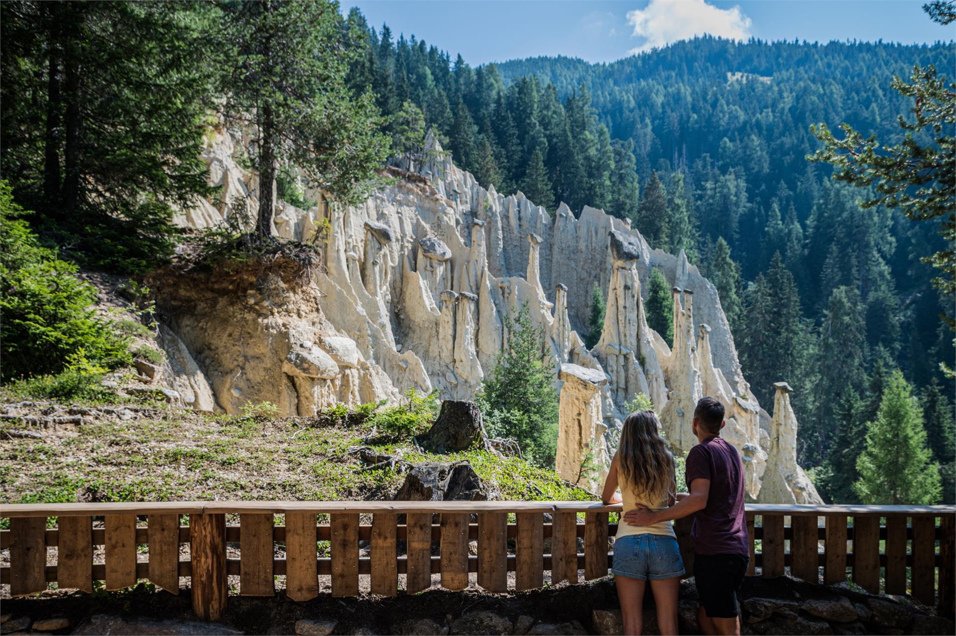
    The Renon/Ritten earth pyramids are a phenomenon caused by erosion, appearing where ice age moraine loam from glaciers collected in the valleys. When dry, the material is as hard as rock but, combined with water, it becomes a clay-like mush which flows into the valley. It remains protected from the rain under large stones so that columns of earth are built up becoming taller after each rainstorm.

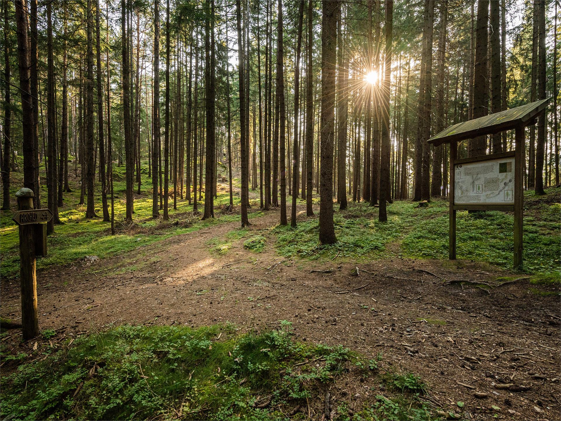
    Route: the hike begins in Collalbo/Klobenstein, the main village on the Corno del Renon mountain. The trail leads through Collalbo to Longomoso/Lengmoos until to the hiking trail no 24 in the Erdpyramidental valley, which is so flat that it can be walked with any sort of shoe and with a buggy. View the earth pyramids against the backdrop of the imposing Dolomites from the viewing terraces. Return via the same route, through Longomoso to the beginning of trail no. 37, the von-Eyrl Promenade and the starting point at the railway station in Collalbo.

    Tip: the easy way to get from Bolzano/Bozen to Collalbo is on the Rittner Seilbahn cable car and Rittner Bahn narrow-gauge railway.

    Poziom trudności: łatwy
    0 wysokość w górę
    1h:19 min czas trwania
    Hiking
    Hiking to the earth piramids near Oberbozen
    Ritten/Renon, Bolzano/Bozen and environs

    Tourism in Renon/Ritten can look back on a long tradition rooted in the desire of the town dwellers of Bolzano/Bozen to escape to their summer retreats. The Renon Themed Trail tells the stories of the Rittnerbahn narrow gauge railway, the tracks of the emperor, the earth pyramids, water and stone, Saint George and Jacob, as well as summer retreats in Santa Maria Assunta/Maria Himmelfahrt.


    Poziom trudności: średni
    275 wysokość w górę
    1h:21 min czas trwania
    Hiking
    LandArt trail
    Pfalzen/Falzes, Dolomites Region Kronplatz/Plan de Corones

    The walk through the LandArt path is a simple, family-friendly hike through the forests of Falzes/Pfalzen. LandArt is art in nature and with nature - nature is its space. With various materials and techniques the artists create their unique works using what nature offers and integrating artistic notes. This art is temporary, exposed to the weather conditions and changes along with nature.

    Poziom trudności: łatwy
    49 wysokość w górę
    1h:00 min czas trwania
    Hiking
    Earth Pyramids
    Rasen-Antholz/Rasun Anterselva, Dolomites Region Kronplatz/Plan de Corones

    From Niederrasen or Oberrasen (following the mark n. 4 or 3) > up to Redensberg > take the paths with the marks n. 4, 1a and 17 to Aschbach > Niedristhof (rest station) > earth pyramids (the last stretch is quite steep). To go back to Rasen take the same path on the opposite direction or as an alternative continue until Platten and Oberwielenbach (mark n. 16) and lastly Percha (possibly by bus from Percha to Rasen).

    Poziom trudności: trudny
    687 wysokość w górę
    2h:30 min czas trwania
    Hiking
    Ruins Castle Altrasen
    Rasen-Antholz/Rasun Anterselva, Dolomites Region Kronplatz/Plan de Corones

    From Niederrasen (church) > from 500 m in direction > Oberstall (mark n. 20) > on the edge of the woods turn right > ruins of Altrasen.

    Poziom trudności: średni
    147 wysokość w górę
    0h:30 min czas trwania
    Hiking
    "Dein Weg" Ladurns
    Brenner/Brennero, Sterzing/Vipiteno and environs
    A popular half-day tour. Enjoy the beauty of nature and recharge your batteries in Ladurns. Starting at Ladurns mountain station, take the Ladurns circular trail to Hinkerboden, followed by Panoramablick, Wastenegg and Hirschlackn. From there take "Dolomieuweg/6-Almen-Weg" via Toffring to Pfoffnberg, Hauseben, Allrisstal, Plottn and Blintekofl. From Blintekofl descent to St. Anton/San Antonio Pflersch valley to the Bront place of power.
    Poziom trudności: średni
    712 wysokość w górę
    6h:00 min czas trwania
    Hiking
    Wine Hiking Trail
    Klausen/Chiusa, Brixen/Bressanone and environs

    From the swimming pool in Chiusa/Klausen, you walk along the main road to the crossroads for Velturno/Feldthurns. Follow the marked Wine Trail (Weinwanderweg), first along the road and then through the Leitach vineyards past various wineries up to the Hienghof farm and from there back down to the swimming pool. On the way you will get a fascinating insight into winegrowing in the Eisacktal valley and learn about the different varieties of grape.

    Poziom trudności: średni
    0 wysokość w górę
    1h:49 min czas trwania
    Hiking
    Chestnut Experience Trail
    Lana, Meran/Merano and environs

    There are various stations where visitors can learn lots about chestnuts. The Chestnut Experience Trail (Kastanienerlebnisweg) is especially recommended for families and those who like a gentle walk. Along the trail one can learn a lot about the tree's wood, its fruit and the various types of chestnut.

    Parking is available next to the church in Foiana/Völlan or at the football ground. Follow the Propst-Wieser-Weg trail. After the sporting grounds a Keschtnigl, a spiky chestnut the size of a person, advertises the Chestnut Experience Trail.

    Follow the signs past the Weinreichhof farm to the start of the Chestnut Experience Trail. The trail is designed to be easy and interesting for young and old. Ten stations, some of them interactive, await visitors on a hike through the chestnut trees where it is all about the precious fruit.

    Poziom trudności: łatwy
    131 wysokość w górę
    0h:49 min czas trwania
    Hiking
    Farm Trail in Ulten Valley
    Ulten/Ultimo, Meran/Merano and environs

    The Ultner Höfeweg farms hiking trail  leads past ancient farmyards. Fantastic views of the surrounding mountains are available from here.

    Poziom trudności: łatwy
    0 wysokość w górę
    5h:10 min czas trwania
    Hiking
    Adventure trail "On the trail of water"
    Brenner/Brennero, Sterzing/Vipiteno and environs

    Welcome to the kingdom of Gossy and Gschnitzy! The two waterdrops tell their exciting story along two trails in North and South Tyrol. You can relive the adventures of the lively drops and learn a lot of interesting facts about water.

    Pflerscherbach/Rio Fleres river boardwalk with various play stations for kids regarding "water" and "climbing". The hike begins at the sports field in Gossensass/Colle Isarco and leads to the valley Pflersch/Fleres. It is possible to return by public bus.

    Poziom trudności: łatwy
    278 wysokość w górę
    2h:45 min czas trwania
    Hiking
    Pflersch/Fleres river boardwalk
    Brenner/Brennero, Sterzing/Vipiteno and environs

    The promenade walk starts by the football ground Gossensass/Colle Isarco and follows the river to the valley bottom. It ends in Außerpflersch/Fleres di Fuori. Suitable for strollers.

    Poziom trudności: łatwy
    36 wysokość w górę
    1h:01 min czas trwania
    Hiking
    Trail to the mills in Bulla
    Urtijëi/Ortisei, Dolomites Region Val Gardena

    The old mills of Bulla, a hamlet situated above Ortisei, were built in the 18th-19th century and were used to grind the locally grown cereals. The hike starts from the bus stop in Bulla and follows the steep street to the farmhouses Tuene and Kontot, follow the trail 3A until you get to a street. Take the street upward for 300 meters and then turn left downhill along the rill to the mills. The path continues in direction of the church and brings you again to the bus stop.

    Poziom trudności: średni
    0 wysokość w górę
    2h:00 min czas trwania
    Hiking
    Archaeological Panoramic Trail
    St.Lorenzen/San Lorenzo di Sebato, Dolomites Region Kronplatz/Plan de Corones

    Archaeological thematic hike in St. Lorenzen/San Lorenzo, around the hill "Sonnenburger Kopf". 

    Poziom trudności: łatwy
    65 wysokość w górę
    1h:45 min czas trwania
    Hiking
    Jochtal adventure park
    Mühlbach/Rio di Pusteria, Brixen/Bressanone and environs

    Starting point: Jochtal restaurant with zip-line swing and maxi trampoline
    Point of arrival: Stoanermandl panoramic platform

    Poziom trudności: łatwy
    162 wysokość w górę
    0h:58 min czas trwania
    Hiking
    The Geologist's Trail
    Kastelruth/Castelrotto, Dolomites Region Seiser Alm

    The Geologists’ Trail takes you on a journey through the history of the Earth. Over millions of years waters of the Frötschbach stream have eroded the rock strata, revealing how the Dolomites came into being. With spectacular waterfalls en-route, this trail offers hikers and amateur geologists a beautiful hike and a fascinating insight into the Earth’s history.

    Poziom trudności: średni
    613 wysokość w górę
    4h:10 min czas trwania
    Hiking
    Hike from the Gardena Pass to the Puez - Odle Nature Park
    Corvara, Dolomites Region Alta Badia

    The Puez-Odle Nature Park, a UNESCO World Heritage Site, is also known as "the witness to the geological history of the Dolomites". The natural park is particularly interesting from a geological and geomorphological point of view, with many typical rock formations and strata that are characteristic of the Dolomites.

    The hike in the south-eastern part of the Puez-Odle Nature Park presents no great technical difficulties for hikers.

    Poziom trudności: średni
    581 wysokość w górę
    4h:32 min czas trwania
    Hiking
    Pfunders Farm trail
    Vintl/Vandoies, Brixen/Bressanone and environs

    The farm trail leads from the village of Fundres/Pfunders by the Parthof farm to the viewing platform overlooking the Pichlerhof farm, then on down through the woods and for a short distance along the Pfundererbach stream. From here the trail leads over a bridge, past the Obergasserhof farm and, after the Wieserhof farm, down to the road, over the bridge and through the fields and meadows back to the starting point. There are frequent information boards to stop and read.

    Poziom trudności: średni
    0 wysokość w górę
    3h:30 min czas trwania
    Hiking
    Gitschberg Sun Park
    Vintl/Vandoies, Brixen/Bressanone and environs

    Starting point: right by the mountain terminal of the Nesselbahn lift
    Point of arrival: Gitschhütte hut with large play area and maxi trampoline

    Poziom trudności: łatwy
    98 wysokość w górę
    0h:19 min czas trwania
    Hiking
    Oswald von Wolkenstein Path
    Kastelruth/Castelrotto, Dolomites Region Seiser Alm

    The Oswald von Wolkenstein trail is a loop trail that leads past the ruins of Salegg and Hauenstein, and features 15 stations where you can stop and play. There’s a lot to discover along this tour, including a knight’s table, a knight‘s sword and mystical animals.

    This hiking tour can be found in the family hiking booklet “Out and About with Nix the Witch”.

    Poziom trudności: łatwy
    280 wysokość w górę
    2h:00 min czas trwania
    Hiking
    Theme path: Olperl alpine circuit for families
    Sexten/Sesto, Dolomites Region 3 Zinnen

    An entertaining alpine circuit for the entire family!                                                             

    Poziom trudności: łatwy
    154 wysokość w górę
    1h:00 min czas trwania
    Hiking
    Hike from San Cassiano to the Fanes Plateau
    La Val, Dolomites Region Kronplatz/Plan de Corones

    The Fanes-Sennes-Prags Nature Park has been included in the list of UNESCO World Heritage Sites on account of its distinctive natural features. The unique, legendary atmosphere of Fanes, the flora and fauna of the Dolomites and the stunning scenery all make this hike an unforgettable experience.
    From our area, Fanes is reachable from Sciaré/San Cassiano.

    Poziom trudności: średni
    563 wysokość w górę
    5h:30 min czas trwania
    Hiking
    Hiking tour to the Earth pyramides
    Percha/Perca, Dolomites Region Kronplatz/Plan de Corones

    The walk to the earth pyramids of Plata is suitable for families and leads to a unique attraction in the Dolomites. 

    Poziom trudności: łatwy
    140 wysokość w górę
    0h:34 min czas trwania
    Hiking
    To the Redwitzplatz/Radura Redwitz
    Brenner/Brennero, Sterzing/Vipiteno and environs

    From the river broadwalk to the Redwitzplatz/Radura Redwitz with its chalybeate spring and from here we have the possibility to arrive at the Alps of Vallming/Valmigna, Rosskopf/Monte Cavallo, Ladurns or back to the river broadwalk.

    Poziom trudności: łatwy
    37 wysokość w górę
    0h:34 min czas trwania
    Hiking
    Hike Along the Lasa Marble Trail – Schrägbahnsteig Trail
    Laas/Lasa, Vinschgau/Val Venosta

    The trail is located in the Stilfserjoch National Park and leads through a forest of spruce and larch.
    Five information boards provide information about the history of the inclined railway:

    the valley station and the construction of the incline railway from 1929
    technical data about the incline railway
    the St Martin church constructed in the 17th century, as well as marble transport in times before the construction of the incline railway when boulders were transported into the valley by means of brake slides,
    hemp-rope pulleys and flatbed wagons pulled by oxen 
    the mountain station with the machine house, the drive engine and the cylinder rope winch 
    a brief company profile of the marble works in Lasa and a list of the historical mining sites

    The hike can be done as a circular route, in combination with a visit to the “Gurgl” gorge in the lower Laaser Tal valley.
    This section of the hike is not recommended for those uncomfortable with heights. All others can go along the trail through the Laaser Tal valley.

    Poziom trudności: średni
    523 wysokość w górę
    1h:49 min czas trwania
    Hiking
    Hiking to the San Felice lake
    U.L.Frau i.W.-St. Felix/Senale-S.Felice, Meran/Merano and environs

    Enjoyble hiking tour through the forests and alpine pastures of Alta Val di Non, highly recommended over the late spring - early summer months because of the great variety of alpine flowers and in autumn due to its glowing larches. The hike starts at the parking area “Klammbrücke” just above the village of San Felice. From there the hiking trail no. 9 leads you directly to the San Felice lake (called also Felixer Weiher or Lago di Tret) in about 1 hour. The hike takes you through rough forests and mountain grassland whit panoramic views to the Val di Non and the Brenta Dolomites. The swimming lake (1604 m) has preserved itself as a natural biotope and has been rewarded for its excellent water quality. Not far from the lake there is the Felixer Alm - Malga di San Felice where you can rest end enjoy local dishes. The forest road from the Felixer Alm brings you back to the parking area. This hiking is also recommended for families with children.

    Poziom trudności: łatwy
    0 wysokość w górę
    1h:10 min czas trwania
    Hiking
    Dolomieu trail - Hike
    Sterzing/Vipiteno, Sterzing/Vipiteno and environs

    The Dolomieu Trail goes across six mountain pastures from the Rosskopf mountain in Sterzing / Vipiteno via Ladurns into the Pflerschtal valley. Enjoy beautiful panoramic views of the Dolomites from Rosskopf and hike past the idyllic Alpine village of Valleming towards the Pflerschtal valley where Deodat de Dolomieu discovered the dolomite rock at the foot of the Tribulaun mountain.

    Poziom trudności: średni
    1133 wysokość w górę
    7h:40 min czas trwania
    Hiking
    Excursion to the Grohmann monument
    Urtijëi/Ortisei, Dolomites Region Val Gardena
    Enjoy a shady hike to the Paul Grohman Monument, the first climber of the Sassolungo. This route winds through a forest, providing shelter from the sun. Immerse yourself in nature and discover the monument dedicated to the pioneer Paul Grohman.
    Poziom trudności: średni
    0 wysokość w górę
    0h:49 min czas trwania
    1 2 3 4 5 6 7 8 9 10 11 12 13 14 15 16 17