Přeskočit na obsah

přidáno k oblíbeným

odebráno z oblíbených

Jejda! Došlo k problému, zkuste to prosím znovu

Vytváří se váš účet

Váš účet byl úspěšně vytvořen a nyní jste přihlášeni

Jste úspěšně přihlášeni!

Váš účet byl úspěšně vytvořen, ale nepodařilo se nám vás automaticky přihlásit

Jste odhlášeni

Filtr
Vybrané filtry
    Úroveň obtížnosti
    Doba trvání
    Vzdálenost v km

    Lezecké trasy v horách Jižního Tyrolska

    Snažte se vysoko v horách Jižního Tyrolska. Připoutáni na laně na jedné z našich horolezeckých tras, tzv. via ferratách, můžete dosáhnout vrcholů nepřístupných běžným turistům a zdolat stěny, které jsou jinak viditelné jen zespodu. Více než 50 tras via ferrata vede po nejkrásnějších horských vrcholech Jižního Tyrolska, mnohé z nich v Dolomitech, které jsou zapsány na seznamu světového dědictví UNESCO. Kromě různých stupňů obtížnosti a vynikajícího značení jsou trasy každoročně kontrolovány, aby bylo zajištěno naprosto bezpečné užívání této formy lezení a majestátních scenérií.
    Výsledky
    Climbing
    Via ferrata "Heini Holzer" Ifinger - access from Merano 2000
    Hafling/Avelengo, Meran/Merano and environs

    The 500 m long climb is perfectly secured with 1000 m of steel cable, is rated at medium difficulty (A - B – in some places B/C) and is suitable for the less strong alpinists or for families with enthusiastic young climbers (14 years and older). An early start, alpine experience and a good overall physical condition is a prerequisite for the ascent of the climbing route. Along the ascent, there is no water and no escape routes. A withdrawal is possible only by down-climbing. The via ferrata is fully secured with a steel cable and no passages have to be dealt with in unsecured terrain or by free climbing. Many steep and difficult sections have been mitigated with steel clamps, which function as steps. Nevertheless, the last part of the via ferrata, the so-called Angel’s edge, presents a very impressive rock passage. The orientation of the via ferrata to the southwest allows for an early ascent of the route, and the climbing season extends well into late autumn (total climbing time: 2-3 hours).

    Obtížnost: střední
    750 m nadmořská výška
    4h:30 min doba trvání
    Climbing
    Via ferrata: Dolomites without borders - stage 8 - RIF. PORZE-HÜTTE - RIF. FILMOOR-STANDSCHÜTZEN-HÜTTE
    Sexten/Sesto, Dolomites Region 3 Zinnen

    "DOLOMITES WITHOUT BORDERS" - The project was born out of the idea that the Dolomites should no longer be a barrier but a place of meeting and friendship. A high-altitude trekking route including 12 „via ferrata“ - each of them unique from alpine or historical points of view. They are interlinking Italy with Austria. The project extends over the areas of the Cadore and the Hochpustertal, area of the Drei Zinnen all the way to the Tiroler Gailtal. "DOLOMITES WITHOUT BORDERS" runs partly along ancient warpaths, trenches and galleries, a "peace path" on former war sites. An Alpine experience for all mountain enthusiasts!

    Obtížnost: střední
    1050 m nadmořská výška
    7h:00 min doba trvání
    Climbing
    Via Ferrata Santnerpass
    Tiers am Rosengarten/Tires al Catinaccio, Dolomites Region Seiser Alm

    The outstandingly beautiful Via Ferrata Santner is secured with steel ropes, iron hooks and ladders, it leads you through small gullies and narrow passes, the most challenging of which is the “Ice Gully”, a small gully which is often covered in hard-packed snow even in August. Due to risk of landslides, this route should only be climbed uphill and not downhill. After you leave the Ferrata at the Santnerpass mountain hut, the trail goes on to the refuge Gartlhütte Hut through the valley of Vajolettal and the Tschagerjoch back to the Kölnerhütte Hut.

    Obtížnost: vysoká
    957 m nadmořská výška
    3h:49 min doba trvání
    Climbing
    Climbing path "Cima dei Colli Alti/Hochalpenkopf"
    Olang/Valdaora, Dolomites Region 3 Zinnen

    Short, not particulary difficult climbing path with long rising and falling section in an isolated area. Good orientation skills required. From the car park directly at the lake along the road to the “Riedlhof”, then on the path no. 20 to “Alpe di Pra della Vacca/Kühwiesenhütte” and continue on the path no. 61 and the climbing path until the peak of “Cima dei Colli Alti/Hochalpenkopf”. Walking time: 6 hours Challenge: ** (moderate difficulty)

    Obtížnost: střední
    1044 m nadmořská výška
    3h:07 min doba trvání
    Climbing
    Via ferrata tour: VIA DELLA PACE (the peace trail)
    Al Plan/San Vigilio, Dolomites Region Kronplatz/Plan de Corones

    Via ferrata tour: VIA DELLA PACE (Peace Trail, extended in 2003)
    Fanes > Gran Fanes › Furcia Rossa (2791 m, H: 2 hours) › First follow the trail marked VB, then turn right after approx. 1.5 hours.

    Obtížnost: střední
    1399 m nadmořská výška
    5h:13 min doba trvání
    Climbing
    Via ferrata: Punta Anna - Giuseppe Olivieri
    Badia, Dolomites Region 3 Zinnen

    The Giuseppe Olivieri via ferrata to Punta Anna leads steeply up the southern edge of the Tofana, in the middle of the Dolomites around Cortina.

    Obtížnost: vysoká
    770 m nadmořská výška
    4h:00 min doba trvání
    Climbing
    Nives (Forcella Nives - Piz Duleda)
    S.Crestina Gherdëina/Santa Cristina Val Gardana, Dolomites Region Val Gardena
    The short via ferrata in the Puez-Odle mountain range in the Cisles valley connects Forcella Roa (path no. 3A) with Forcella Nives. It then continues to the 2,909-metre-high Piz Duleda (path no. 3B). The magnificent 360° scenic view from Piz Duleda encompasses the Fanes Group, Cir peaks, Sella Group, Sassolungo, Seiser Alm, Pic Peak, and the Odle.
    Obtížnost: střední
    900 m nadmořská výška
    7h:00 min doba trvání
    Climbing
    Via Ferrata: Arzalpenturm
    Sexten/Sesto, Dolomites Region 3 Zinnen
    Approach

    From the passo Monte Croce 1.636m

    450 m – 1,5 hrs

    From the passo, take path no. 124 southwards until you reach Forcella Plan della Biscia (1,942 m) next to Cima Colesei. From there you continue along the old and wide road from the war. A few hundred meters after a prominent curve, you will find a sign and a small stone man. From there you turn left (2.010m) to arrive to the attack of the via ferrata. This climb is not yet well trodden on, but is marked with red dots. It is advisable to wear a helmet in advance, as in the last section you are just below the via ferrata and therefore exposed to a greater risk of falling rocks.

    From the Lunelli hut 1.568m

    510 m – 1,5 hrs

    From the hut you climb up to the Forcella Plan della Biscia (1,942 m) via path no. 171 or alternatively via the wide path no. 155. From there you continue along the old and wide road from the war. A few hundred meters after a prominent curve, you will find a sign and a small stone man. From there you turn left (2.010m) to arrive to the attack of the via ferrata. This climb is not yet well trodden on, but is marked with red dots. It is advisable to wear a helmet in advance, as in the last section you are just below the via ferrata and therefore exposed to a greater risk of falling rocks.

    Route description

    2,5 hrs – level C/D

    The entrance is located in a small rubble chute in which the steel cable begins. The path starts off in the same demanding way (D) and then follows a steep rock pillar (C/D) with quite homogeneous difficulty.

    After the first difficult third, it continues in easier terrain (A/B) until you reach the ridge of the Arzalpenturm after a traverse (C) and a steep step (C/D).

    Crossing the ridge, one reaches a small saddle next to the actual summit of the Campanile Colesei. Here, there is a one-way regulation. The actual summit of the tower can only be reached with an additional variant. One climbs down from the saddle along the steel cable south (C). Soon one reaches a junction with the variant. If you like, you can climb the Campanile Colesei (C/D) and get back to this point in one round. From the junction, follow the path downwards to a saddle (C) from where the steel cable on the opposite side climbs up to the plateau of the Croda Sora I Colesei (C).

    Obtížnost: střední
    1042 m nadmořská výška
    3h:28 min doba trvání
    Climbing
    Via ferrata: Col Rosá - Ettore Bovero
    Badia, Dolomites Region 3 Zinnen

    The Col Rosá via ferrata is varied, very steep in short sections and also exposed, but consistently on good rock.
    It is especially beautiful in autumn, when the colored deciduous trees round off the picture.

    Obtížnost: střední
    883 m nadmořská výška
    5h:00 min doba trvání
    Mountaineering
    Überetscher Hütte - Roen (Klettersteig)
    Tramin an der Weinstraße/Termeno sulla Strada del Vino, Alto Adige Wine Road

    From the festival place the via Molino up, to the forest road. The wood sign “Gummererhof” points us the direction. Starting from the “Gummerhof” moving way nr. 10 to the steep “Weiße Rissen” and the “Kleinen Göller” (water place), left up to the marking T from Termeno, leads into our moving way. Through seal coniferous forest, way nr. 523, further, past at the hunter hut, up to the waterfall, then 20 min. laborious rise to the “Rifugio Oltradige – Überetscher Hütte” (mountain inn).

    To reach the peak of Roen from the „Überetscher Hütte“ there exist two variants:
    1) for those who are ambitious and doesn’t suffer from vertigo: via ferrata (marking 523), to the peak of Roen (2116m above sea level), then down through meadows (marking 500) to the mountain pasture of Roen, and again to the „Überetscher Hütte“.
    2) The marking 10/560 in the northward direction until the mountain pasture of Roen and over the trail (marking 500) to the Roen. The way back to the Passo della Mendola or descend through the „Tauris“ (marking 10A) direct to Tramin.

    Obtížnost: střední
    2610 m nadmořská výška
    8h:18 min doba trvání
    Climbing
    Via ferrata: Punta Fiames - Michelli Strobel
    Badia, Dolomites Region 3 Zinnen
    The Michelli Strobel via ferrata on Punta FIames is repeatedly interrupted by inclined ribbons and offers a view of Cortina d’Ampezzo.
    Obtížnost: střední
    404 m nadmořská výška
    1h:08 min doba trvání
    Climbing
    Pisciadù (Tridentina al Pisciadù)
    Corvara, Dolomites Region Val Gardena

    The imposing mountain scenery of the Sella Group, the waterfall, the vertical climbing passages at Exner Tower, a suspension bridge and a mountain lake make the Pisciadù via ferrata
    one of the most popular and busiest in the Dolomites. 


    Obtížnost: vysoká
    830 m nadmořská výška
    2h:55 min doba trvání
    Climbing
    Gran Cir (Gran Cir Peak)
    Corvara, Dolomites Region Val Gardena

    The fairly short yet busy via ferrata boasts a magnificent view of the north face of the Sella
    Group, the Sassolungo and the Puez plateau.


    Obtížnost: nízká
    461 m nadmořská výška
    1h:30 min doba trvání
    Climbing
    Climbing route Punta Tabaretta/Tabarettaspitze
    Stilfs/Stelvio, Vinschgau/Val Venosta

    The via ferrata Tabaretta  is one of the most difficult and impressive in Europe. The via ferrata has many steep passages and not so many resting places. The mountain scenery and the perfect view of the Ortler north face is priceless, which is why this tour is a must.

    Obtížnost: vysoká
    835 m nadmořská výška
    3h:25 min doba trvání
    Climbing
    Fixed rope route Hochalpenkopf
    Olang/Valdaora, Dolomites Region Kronplatz/Plan de Corones

    An approvpriate mountain shoe is required to go through the way, that ends at the Kaserkopf. Reach the Hochalpenkopf across a glade toward sud.


    Obtížnost: střední
    368 m nadmořská výška
    1h:13 min doba trvání
    Climbing
    Latemar Towers Via Ferrata
    Deutschnofen/Nova Ponente, Dolomites Region Eggental

    Long but panoramic Alpine tour featuring an easy via ferrata between the Latemar towers. 

    Obtížnost: střední
    1140 m nadmořská výška
    6h:55 min doba trvání
    Climbing
    Sas Rigais (Odle)
    S.Crestina Gherdëina/Santa Cristina Val Gardana, Dolomites Region Val Gardena
    Together with the Furchëta, it is the highest peak of the Odle group. The Group is considered Reinhold Messner’s backyard. It boasts a stunning 360° view of the Puez plateau, Stevia,  Sassolungo and the Val di Funes. A demanding tour with a long ascent and descent and some unsecured passages, it requires a sure-footed approach. We are featuring the east-south trek.
    Obtížnost: střední
    1105 m nadmořská výška
    6h:30 min doba trvání
    Climbing
    Sasplat (Oskar Schuster Steig/Sasso Piatto)
    S.Crestina Gherdëina/Santa Cristina Val Gardana, Dolomites Region Val Gardena
    Wonderful but demanding via ferrata on one of the seven peaks of the Sassolungo Group. The climb develops along the Sassopiatto plateau and, turning to the north, you can admire the view of the Odle. The partly unsecured climb is rewarded with a unique view of the Marmolada and the Alpe di Siusi. This is a long mountain tour due to its descent over the Sasso Piatto ridge. Avoid it if the weather is not absolutely perfect.
    Pay attention! Potential rockfall – keep your eyes open.
    Obtížnost: vysoká
    1436 m nadmořská výška
    8h:30 min doba trvání
    Climbing
    Via ferrata: Tofana di Roces - Giovanni Lipella
    Badia, Dolomites Region 3 Zinnen

    This via ferrata is a very long and demanding mountain tour that requires mountain experience, knowledge of the weather and a very good physical condition. The long ribbons, which are well secured in the exposed areas, lead again and again in the lower part to the steep steps that connect the crossings.

    Obtížnost: vysoká
    1633 m nadmořská výška
    8h:00 min doba trvání
    Climbing
    Via ferrata: Alpinisteig
    Sexten/Sesto, Dolomites Region 3 Zinnen

    The Alpinisteig is a well-maintained mountain climbing trail dating from the First World War which shows just how well constructed these former military trails were. The section between the Elfer- and Sentinellascharte gaps is very icy even in summer, so crampons, pickaxes and ropes are essential.
    Starting point: Zsigmondyhütte mountain hut
    Map/literature: Tabacco no. 010

    Only walkable if the current weather conditions are good. WARNING: The GPX data may differ from reality.

    before departure: check the equipment, the weather conditions and the accessibility

    Obtížnost: vysoká
    600 m nadmořská výška
    7h:00 min doba trvání
    Climbing
    Via Ferrata Maximilian
    Kastelruth/Castelrotto, Dolomites Region Seiser Alm

    The Via Ferrata Maximilian is not technically demanding, although it is unsecured in places over a scree-ridge. Sure-footedness and a head for heights are a must. The Ferrata traverses the entire Rosszahnkamm ridge – from the summit of the Großer Rosszahn to the Roterdspitze – and boasts outstanding views over the Seiser Alm and the peaks of the Dolomites.

    Obtížnost: střední
    401 m nadmořská výška
    1h:28 min doba trvání
    Climbing
    Via ferrata Brigata Alpina Tridentina al Pisciadù
    Corvara, Dolomites Region Alta Badia

    The Dolomites, which many people regard as the most beautiful mountains in the world, are an awesome challenge that climbers and mountaineers shouldn't miss. Vertical rock faces and steep towers guarantee plenty of climbing challenges. Doubtless, one of the most famous fixed-rope routes in the Dolomites is the via ferrata Pisciadú (also known as the Via Ferrata Tridentina) in the Sella massif. The via ferrata, easily reachable from Colfosco, has some intriguing vertical sections and a suspension bridge.

    Obtížnost: vysoká
    0 m nadmořská výška
    2h:45 min doba trvání
    Climbing
    Via Ferrata Kesselkogel
    Kastelruth/Castelrotto, Dolomites Region Seiser Alm

    From the Molignon Pass/Grasleitenpass, the road up to the left leads to the Rosengarten Antermoia/Kesselkogel.

    Obtížnost: vysoká
    638 m nadmořská výška
    1h:21 min doba trvání
    Climbing
    Via ferrata tour PIZ DA PERES
    Badia, Dolomites Region Kronplatz/Plan de Corones

    The new via ferrata "PIZ DA PERES", built for the 2022 summer, consists of three interesting sections with a difficulty rating C/D (difficult). The via ferrata is located in a favorable geographical position and offers very good accessibility, with short access routes and breathtaking panoramic views. While climbing the via ferrata, you will have an exclusive vantage point to admire the mountain ranges of the Dolomites, the Zillertal and the Rieserferner Alps. You will be able to experience a spectacular mountain adventure, surrounded by beautiful scenery.

    Still in need of a via ferrata set? No problem, you can rent it from MIARA Bike Rental or at the shop Sport Sagmeister in Valdaora.

    Obtížnost: střední
    186 m nadmořská výška
    1h:31 min doba trvání
    Climbing
    Via ferrata Small Cir
    Corvara, Dolomites Region Alta Badia

    Short, steep via ferrata on solid rock with good grip. Easy access and gorgeous panorama.

    Obtížnost: střední
    397 m nadmořská výška
    1h:16 min doba trvání
    Climbing
    Via ferrata: Fanes Valley - G. Barbara
    Badia, Dolomites Region 3 Zinnen
    The short waterfall via ferrata is located in the Val di Fanes, which is just out of Cortina d'Ampezzo.
    Obtížnost: nízká
    575 m nadmořská výška
    3h:00 min doba trvání
    Mountaineering
    Hiking to the Piz Boé peak in the Sella Massif
    Corvara, Dolomites Region Alta Badia
    Piz Boé, in the Sella Group, stands at 3,152 meters and is one of the most accessible peaks over 3,000 meters, making it a popular destination for hikers. However, it's important to note that the ascent from Corvara and the return to Passo Gardena, as outlined in this route, are quite demanding. While climbing equipment isn't required, sure-footedness and mountain experience are essential for tackling this hike. The route primarily traverses rocky terrain, with sections of scree and an equipped trail. As you ascend, the landscape changes, offering breathtaking views of some of the most iconic Dolomite peaks, including the Marmolada, Civetta, Catinaccio, and Sassolungo. At the summit, you'll find the small Capanna Piz Fassa hut, where you can spend the night. However, the true reward is the stunning panorama that only an altitude of over 3,000 meters can provide. The descent involves crossing part of the massif before reaching Gardena Pass.
    Obtížnost: vysoká
    904 m nadmořská výška
    3h:21 min doba trvání
    Climbing
    Via ferrata: Col dei Bos
    Badia, Dolomites Region 3 Zinnen

    The challenging via ferrata has at one point grade D with a protruding stretch. The whole via ferrata is secured by a very taut, thick rope and anchors placed at short gaps.


    Obtížnost: vysoká
    488 m nadmořská výška
    3h:30 min doba trvání
    Climbing
    Via Ferrata: Paternkofel
    Sexten/Sesto, Dolomites Region 3 Zinnen

    Highly recommendable fixed-cable climbing path for experienced via ferrata climbers Starting point: Locatelli/Drei Zinnen Hut

    This via ferrata is only suitable for experienced via ferrata climbers who are sure-footed, have a good head for heights and a lot of stamina.

    From the Drei Zinnen hut the trail takes towards the “Frankfurter" rock and then enters into the tunnel. At the end of the tunnel the fixed-cable trail takes to the Gamsscharte passage. From there, it goes steeply up to the summit. In the scree around the summit, you have to concentrate on your climbing – there are various places where you could get confused and go wrong. From the summit, returns to the Gamsscharte passage and from there it goes down a few metres in a rocky gully and further on at the wartime trail to the Forgella Paterno/Paternsattel.

    The impressive tunnel passages, numerous openings in the rock and an interesting section where you have to crawl, just before the Paternsattel, make this via ferrata extremely exciting and highly recommended, both for its central location in the Sexten Dolomites and for its summit panoramas.

    Only walkable if the current weather conditions are good. WARNING: The GPX data may differ from reality. For information your contact is the Alpinschule Sexten Drei Zinnen +39 0474 710375 info@alpinschule-dreizinnen.com

    Before departure: check the equipment, the weather conditions and the accessibility

    Obtížnost: střední
    728 m nadmořská výška
    3h:00 min doba trvání
    1 2 3

      Eine Vielzahl von unterschiedlichen Schwierigkeitsgraden, eine hervorragende Beschilderung und jährlich geprüfte Routen machen diese Form des Kletterns so sicher wie möglich und zum landschaftlichen Erlebnis.
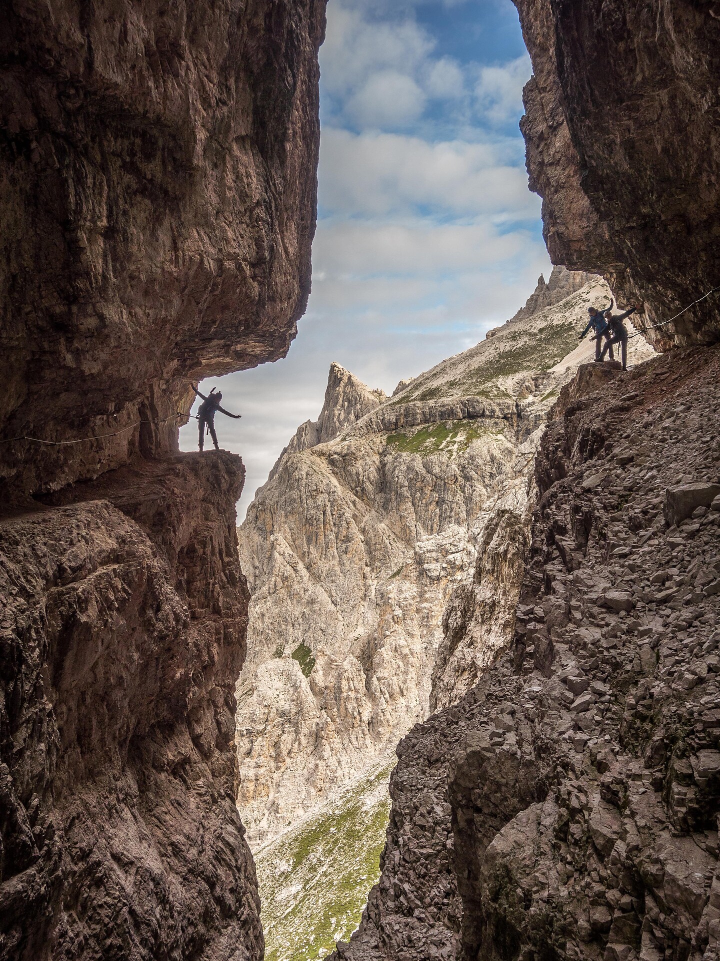