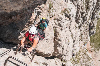
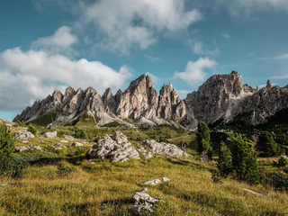
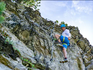
Skip to content
added to favourites
removed from favourites
Oops! Something went wrong. Try again
Your account is being created
Your account has been successfully created and you are now logged in
You are logged out.
Filter
Selected filters
    Level of difficulty
    Duration
    Distance in KM

    Climbing routes in South Tyrol’s Mountains

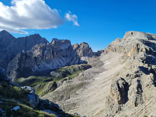
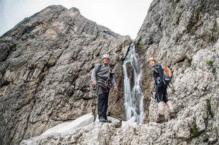
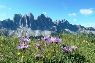
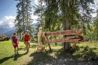
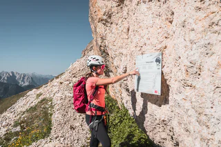
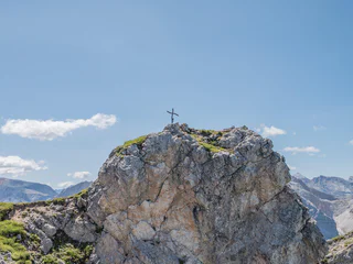
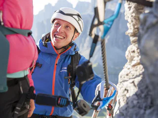
    Aim high in South Tyrol’s mountains. Securely attached to rope on one of our climbing routes called "via ferrata", you can reach peaks unattainable for normal hikers and conquer walls otherwise visible only from below. More than 50 vie ferrate run along South Tyrol’s most beautiful peaks, many of which are located in the Dolomites, a UNESCO World Heritage Site. In addition to a variety of difficulty levels and excellent sign-posting, the routes are checked on an annual basis to ensure a perfectly safe way to enjoy this form of climbing and the majestic scenery.

    Results
    Vie Ferrate
    Via Ferrata Maximilian
    Kastelruth/Castelrotto, Dolomites Region Seiser Alm

    The Via Ferrata Maximilian is not technically demanding, although it is unsecured in places over a scree-ridge. Sure-footedness and a head for heights are a must. The Ferrata traverses the entire Rosszahnkamm ridge – from the summit of the Großer Rosszahn to the Roterdspitze – and boasts outstanding views over the Seiser Alm and the peaks of the Dolomites.

    Difficulty: medium
    401.0 altitude up
    1h:28 min duration
    Vie Ferrate
    Masarè Via Ferrata
    Welschnofen/Nova Levante, Dolomites Region Eggental

    Beautiful, varied via ferrata in the southern Rosengarten massif with fantastic views of the Dolomites.

    Difficulty: difficult
    690.0 altitude up
    5h:00 min duration
    Vie Ferrate
    Climbing the Gran Cir peak at sunrise
    Corvara, Dolomites Region Alta Badia

    The first moments of the morning at the top of a peak, when the shy rays of the sun illuminate the surrounding rocks, making them glow a warm orange-gold colour: breathtaking moments that will remain engraved in your heart forever.
    Just outside Colfosco, on the bends of the Gardena pass, you can enjoy the inimitable spectacle of the Dolomite sunrise as you climb the peaks of the Cir group. Of all the possible climbs, that to the summit of the Gran Cir is the least difficult.

    Difficulty: medium
    2h:04 min duration
    Vie Ferrate
    Hike to the Zuckerhütl Summit (3,507 m) (A)
    Ratschings/Racines, Meran/Merano and environs

    A high mountain climb across the glacier and over the rocks

    This two-day trip is recommended only for those with a head for heights (not for sufferers of vertigo), sure-footed, sturdy climbers with experience in glacier and rock-climbing. Under no circumstances should anyone attempt to climb the flat Schwarzwandscharte wind gap without ropes. Right from the outset there are hidden crevasses under the snow, some of which run in the direction of travel. Some sections of the Wilder Pfaff are rated II on the Difficulty Level Scale (UIAA). The gap below the Zuckerhütl summit is very steep and at times smooth and slippery (note: ice axes and crampons are essential). An experienced guide is highly advisable on this high mountain hiking adventure.


    Starting point: Timmelsbrücke bridge km 19,7

    Endpoint: Timmelsbrücke bridge km 19,7

    Refreshment stop: Timmelsalm pasture, Müllerhütte refuge

    Difficulty: difficult
    1850.0 altitude up
    12h:34 min duration
    Vie Ferrate
    Via Ferrata Santnerpass
    Tiers am Rosengarten/Tires al Catinaccio, Dolomites Region Seiser Alm

    The outstandingly beautiful Via Ferrata Santner is secured with steel ropes, iron hooks and ladders, it leads you through small gullies and narrow passes, the most challenging of which is the “Ice Gully”, a small gully which is often covered in hard-packed snow even in August. Due to risk of landslides, this route should only be climbed uphill and not downhill. After you leave the Ferrata at the Santnerpass mountain hut, the trail goes on to the refuge Gartlhütte Hut through the valley of Vajolettal and the Tschagerjoch back to the Kölnerhütte Hut.

    Difficulty: difficult
    957.0 altitude up
    3h:49 min duration
    Vie Ferrate
    Sass Rigais
    Villnöss/Funes, Dolomites Region Villnösstal

    The Sass Rigais is the main summit of the Geisler and with its 3025 m an absolute must for anyone who wants to conquer the pale mountains. Sure-footedness, head for heights, experience in the mountains and the use of a climbing harness are required. 

    Difficulty: difficult
    1699.0 altitude up
    6h:01 min duration
    Vie Ferrate
    Santner Pass Via Ferrata
    Welschnofen/Nova Levante, Dolomites Region Eggental

    This via ferrata is a classic in the Dolomites and is framed by rugged walls and towers with magnificent views. The via ferrata is relatively short with difficult Alpine passages that require Alpine experience.

    Difficulty: medium
    1125.0 altitude up
    3h:45 min duration
    Mountaineering
    Compatsch – Antermoiasee Lake – Compatsch
    Kastelruth/Castelrotto, Dolomites Region Seiser Alm
    Difficult hike that requires very good physical condition. Good surefootedness, sturdy shoes and alpine experience are necessary.

    The crystal blue Antermoia Lake amidst the barren mountain world of the Dolomites is impressive. There are several refuges along this route that invite you to stop for a bite to eat.
    Difficulty: difficult
    1986.0 altitude up
    9h:13 min duration
    Vie Ferrate
    Hiking to the Piz Boé peak in the Sella Massif
    Corvara, Dolomites Region Alta Badia

    The Piz Boé in the Sella group, at a height of 3,152 m, is one of the most accessible peaks over three thousand metres and, for this reason, very popular with hikers.  However, you should bear in mind that the ascent from Corvara and the return to Passo Gardena proposed in this route are of a demanding level: the use of climbing equipment is not compulsory, but sure-footedness and mountain experience are prerequisites for tackling this hike. The route runs mainly on rocky terrain and in places on scree or on an equipped trail, with a panorama that changes as you ascend and beautiful views of the best-known Dolomite peaks such as the Marmolada, Civetta, Catinaccio and Sassolungo. Once you have reached the summit, you will find the small Capanna Piz Fassa hut, where you can stay overnight, but above all, you will be greeted by the fantastic view that only the over 3000 m altitude can offer. On the way back, you will have to cross part of the massif and then descend to Gardena Pass.

    Difficulty: difficult
    904.0 altitude up
    3h:21 min duration
    Vie Ferrate
    Günther Messner Trail
    Villnöss/Funes, Dolomites Region Villnösstal

    A demanding mountain tour over the alpine via ferrata dedicated to the mountaineer Günther Messner. The route alternates between passages of exposed trails and passages of via ferrata, on which securing with a climbing harness is recommended. Only for those who are free from giddiness!

    Difficulty: difficult
    1327.0 altitude up
    5h:25 min duration
    Vie Ferrate
    Via Ferrata Oskar Schuster
    Sëlva/Selva, Dolomites Region Seiser Alm
    The via ferrata leads over 700 m through steep walls and cirques before you reach the summit at 2,958 m and look down on the Val Gardena valley and the South Tyrolean Dolomites.
    The descent is via the Plattkofel normal trail to the same hut and via the Friedrich August trail back to the Sella Pass.
    Difficulty: difficult
    1511.0 altitude up
    5h:31 min duration
    climbing tour
    Climb: Sarner Scharte
    Sarntal/Sarentino, Bolzano/Bozen and environs

    Climbing Route | Sarner Scharte | Sarner Scharte rises to an elevation of 2,468 metres, directly above Val Sarentino/Sarntal Valley | Climb: Sarner Scharte | Starting point: Sarentino/Sarnthein

    Difficulty: medium
    408.0 altitude up
    1h:04 min duration
    Vie Ferrate
    Via Ferrata Fennberg
    Kurtinig an der Weinstraße/Cortina sulla Strada del Vino, The South Tyrolean Wine Road

    An almost vertical chimney makes the beginning of the via ferrata found 3.8 km south of Margreid. This is followed by rock passageways with brackets, wire ropes and iron ladders. A partially exposed hiking trail leads through scrub forest to the last rock passage (summit book). Then follows a short secured route, until the trail merges into a forest path that leads to the first houses of Unterfennberg. After approx. 300 meters on a paved road, a forest path branches off to the left - marking 3 -. On this you reach the meadow and lake of Unterfennberg (1047 m), where there are two restaurants.

     There are two options for the way back: on the "normal way" (signpost 3) to Margreid and from there either by taxi - taxi Boccher Tel. +39 3356142064 - or on foot about ¾ hour to the starting point. Or from Unterfennberg south following the mark 502 B to Aichholz (Roverè della Luna). From the center on asphalt in a northerly direction about 2 km to your starting point.

     Tip: Do not start too late; the rock walls heat up very fast!

    Difficulty: medium
    820.0 altitude up
    2h:30 min duration
    Vie Ferrate
    Latemar Towers Via Ferrata
    Deutschnofen/Nova Ponente, Dolomites Region Eggental

    Long but panoramic Alpine tour featuring an easy via ferrata between the Latemar towers. 

    Difficulty: medium
    6h:45 min duration
    Vie Ferrate
    Via Ferrata Laurenzi
    Kastelruth/Castelrotto, Dolomites Region Seiser Alm

    The Via Ferrata Laurenzi passes over the Molignon ridge, and is one of the most difficult Via Ferrata routes in the Dolomites. A sure foot, a good head for heights and experience are an absolute must, as, in part, it crosses an exceptionally narrow, exposed ridge. From a scenery point of view, this route promises breathtaking views over the Langkofel range, the Sella massif, the Marmolada and down into the Duron Valley below.

    Difficulty: difficult
    644.0 altitude up
    2h:01 min duration
    Vie Ferrate
    Lampskopf - climbing crag to the Tribulaun hut
    Brenner/Brennero, Sterzing/Vipiteno and environs
    Recently in Pflerschtal/Val di Fleres a new climbing crag has been created, which leads from "Erl" in Innerpflersch/Fleres di Dentro over the Lampskopf, Goglberg and finally the hut Tribulaunhütte/Rifugio Tribulaun (2379m) ; altitude difference 1100 m.
    Difficulty: difficult
    1053.0 altitude up
    3h:30 min duration
    Mountaineering
    Überetscher Hütte - Roen (Klettersteig)
    Kaltern an der Weinstraße/Caldaro sulla Strada del Vino, The South Tyrolean Wine Road

    From the festival place the via Molino up, to the forest road. The wood sign “Gummererhof” points us the direction. Starting from the “Gummerhof” moving way nr. 10 to the steep “Weiße Rissen” and the “Kleinen Göller” (water place), left up to the marking T from Termeno, leads into our moving way. Through seal coniferous forest, way nr. 523, further, past at the hunter hut, up to the waterfall, then 20 min. laborious rise to the “Rifugio Oltradige – Überetscher Hütte” (mountain inn).

    To reach the peak of Roen from the „Überetscher Hütte“ there exist two variants:
    1) for those who are ambitious and doesn’t suffer from vertigo: via ferrata (marking 523), to the peak of Roen (2116m above sea level), then down through meadows (marking 500) to the mountain pasture of Roen, and again to the „Überetscher Hütte“.
    2) The marking 10/560 in the northward direction until the mountain pasture of Roen and over the trail (marking 500) to the Roen. The way back to the Passo della Mendola or descend through the „Tauris“ (marking 10A) direct to Tramin.

    Difficulty: medium
    2610.0 altitude up
    8h:18 min duration
    Vie Ferrate
    To the Sas de Putia passing by Schlüterhütte
    Villnöss/Funes, Dolomites Region Villnösstal

    A challenging hike with a stunning view of Villnöss/Funes valley, the Geisler mountains and the surrounding Dolomites. The last part beneath the summit consists of a via ferrata on which belaying with a climbing harness is recommended. 

    Difficulty: medium
    1275.0 altitude up
    5h:31 min duration
    Vie Ferrate
    Via ferrata tour: VIA DELLA PACE (the peace trail)
    Al Plan/San Vigilio, Dolomites Region Kronplatz/Plan de Corones

    Via ferrata tour: VIA DELLA PACE (Peace Trail, extended in 2003)
    Fanes > Gran Fanes › Furcia Rossa (2791 m, H: 2 hours) › First follow the trail marked VB, then turn right after approx. 1.5 hours.

    Difficulty: medium
    1399.0 altitude up
    5h:13 min duration
    Vie Ferrate
    Via ferrata: Col Rosá - Ettore Bovero
    Badia, Dolomites Region 3 Zinnen

    The Col Rosá via ferrata is varied, very steep in short sections and also exposed, but consistently on good rock.
    It is especially beautiful in autumn, when the colored deciduous trees round off the picture.

    Difficulty: medium
    883.0 altitude up
    5h:00 min duration
    Vie Ferrate
    Via Ferrata Kids Pirate's Rock Speikboden
    Ahrntal/Valle Aurina, Ahrntal/Valle Aurina

    Gain your first experience on a Via Ferrata! The new Via Ferrata at Speikboden is specially designed for children between 6 and 12 years. Under the motto PIRATES the little ones can learn climbing on routes suitable for children.

    It is possible to rent the equipment for the Via Ferrata at the mountain station of the cablecar Speikboden.

    Difficulty: easy
    61.0 altitude up
    1h:00 min duration
    Vie Ferrate
    Via Ferrata Les Cordes
    Badia, Dolomites Region Alta Badia

    The via ferrata Les Cordes, classified as medium to moderate, is a climb with great view points. The via ferrata was built on the edge of the Puez – Odle Nature Park along a centuries-old route.

    Many, many years ago, the farmers of La Villa brought their cows and horses to the Gherdenacia plateau on very steep path. The trail was much steeper and more demanding than all the paths that today lead to the Gherdenacia Plateau. The path was called "les cordes" (Ladin for "the ropes").

    In 2019 a via ferrata, also called "Les Cordes", was built along this route. The starting point of the via ferrata can be easily reached with the Gardenaccia chairlift. From the mountain station of the chairlift it is than only about 5 minutes to the start.

    Difficulty: medium
    238.0 altitude up
    0h:39 min duration
    Vie Ferrate
    Via ferrata Cima Cadini Nordest - Merlone
    Sexten/Sesto, Dolomites Region 3 Zinnen
    Long climb to the ladder section with over 300 rungs. The varied fixed rope route in scenically lovely mountains. Recommended for the hot summer months, as the climb is largely protected by shadow.
    Difficulty: medium
    1022.0 altitude up
    6h:00 min duration
    Vie Ferrate
    Via Ferrata: Torre di Toblin
    Sexten/Sesto, Dolomites Region 3 Zinnen

    Rifugio Auronzo – Rifugio Locatelli – Path of the ladders - Torre di Toblin – return Description: repaired via ferrata with a lot of ladders (17 ladders!) and a wonderful round from the top of the Torre di Toblin. Reachable also from the Val Fiscalina or Val Campo di Dentro. Indications: Access and return red triangles, path nr. 101 and 105 Highlights: the ladders and naturally the view to the Three Peaks (Tre Cime) Starting point: Rif. Auronzo (2320m) Duration: total from the Rif. Auronzo 4 ½ hours, ascent 2 ¾ hours, descent 1 ¾ hours Diffrence of altitude: ca. 300m

    Only walkable if the current weather conditions are good. WARNING: The GPX data may differ from reality. For information your contact is the Alpinschule Sexten Drei Zinnen +39 0474 710375 info@alpinschule-dreizinnen.com

    Before departure: check the equipment, the weather conditions and the accessibility

    Difficulty: medium
    3h:00 min duration
    Vie Ferrate
    Via Ferrata Kesselkogel
    Kastelruth/Castelrotto, Dolomites Region Seiser Alm

    From the Molignon Pass/Grasleitenpass, the road up to the left leads to the Rosengarten Antermoia/Kesselkogel.

    Difficulty: difficult
    638.0 altitude up
    1h:21 min duration
    Vie Ferrate
    Via ferrata: Tofana di Roces - Giovanni Lipella
    Badia, Dolomites Region 3 Zinnen

    This via ferrata is a very long and demanding mountain tour that requires mountain experience, knowledge of the weather and a very good physical condition. The long ribbons, which are well secured in the exposed areas, lead again and again in the lower part to the steep steps that connect the crossings.

    Difficulty: difficult
    1633.0 altitude up
    8h:00 min duration
    Vie Ferrate
    Via ferrata: Dolomites without borders - stage 2 - Rif. Carducci - Three Peaks
    Sexten/Sesto, Dolomites Region 3 Zinnen

    "DOLOMITES WITHOUT BORDERS" - The project was born out of the idea that the Dolomites should no longer be a barrier but a place of meeting and friendship. A high-altitude trekking route including 12 „via ferrata“ - each of them unique from alpine or historical points of view. They are interlinking Italy with Austria. The project extends over the areas of the Cadore and the Hochpustertal, area of the Drei Zinnen all the way to the Tiroler Gailtal. "DOLOMITES WITHOUT BORDERS" runs partly along ancient warpaths, trenches and galleries, a "peace path" on former war sites. An Alpine experience for all mountain enthusiasts!

    Difficulty: difficult
    900.0 altitude up
    7h:00 min duration
    Vie Ferrate
    Via ferrata: Dolomites without borders - stage 9 - Filmoor-Standschützenhütte - Rif. Lunelli
    Sexten/Sesto, Dolomites Region 3 Zinnen

    "DOLOMITES WITHOUT BORDERS" - The project was born out of the idea that the Dolomites should no longer be a barrier but a place of meeting and friendship. A high-altitude trekking route including 12 „via ferrata“ - each of them unique from alpine or historical points of view. They are interlinking Italy with Austria. The project extends over the areas of the Cadore and the Hochpustertal, area of the Drei Zinnen all the way to the Tiroler Gailtal. "DOLOMITES WITHOUT BORDERS" runs partly along ancient warpaths, trenches and galleries, a "peace path" on former war sites. An Alpine experience for all mountain enthusiasts!

    Difficulty: medium
    1200.0 altitude up
    9h:00 min duration
    Vie Ferrate
    Via ferrata: Punta Anna - Giuseppe Olivieri
    Badia, Dolomites Region 3 Zinnen

    The Giuseppe Olivieri via ferrata to Punta Anna leads steeply up the southern edge of the Tofana, in the middle of the Dolomites around Cortina.

    Difficulty: difficult
    770.0 altitude up
    4h:00 min duration
    1 2 3
      image
      Summer
      Uphill Seespitz
      Meran and environs
      Starting point: Töll Etschbrücke (525 m) End point: Gasthaus …
      44 km total slope
      7 lifts
      Highest point: 2,505 m