Přeskočit na obsah

přidáno k oblíbeným

odebráno z oblíbených

Jejda! Došlo k problému, zkuste to prosím znovu

Vytváří se váš účet

Váš účet byl úspěšně vytvořen a nyní jste přihlášeni

Jste úspěšně přihlášeni!

Váš účet byl úspěšně vytvořen, ale nepodařilo se nám vás automaticky přihlásit

Jste odhlášeni

Filtr
Vybrané filtry
    Úroveň obtížnosti
    Doba trvání
    Vzdálenost v km

    Lezecké trasy v horách Jižního Tyrolska

    Snažte se vysoko v horách Jižního Tyrolska. Připoutáni na laně na jedné z našich horolezeckých tras, tzv. via ferratách, můžete dosáhnout vrcholů nepřístupných běžným turistům a zdolat stěny, které jsou jinak viditelné jen zespodu. Více než 50 tras via ferrata vede po nejkrásnějších horských vrcholech Jižního Tyrolska, mnohé z nich v Dolomitech, které jsou zapsány na seznamu světového dědictví UNESCO. Kromě různých stupňů obtížnosti a vynikajícího značení jsou trasy každoročně kontrolovány, aby bylo zajištěno naprosto bezpečné užívání této formy lezení a majestátních scenérií.
    Výsledky
    Mountaineering
    Lampskopf - climbing crag to the Tribulaun hut
    Brenner/Brennero, Sterzing/Vipiteno and environs

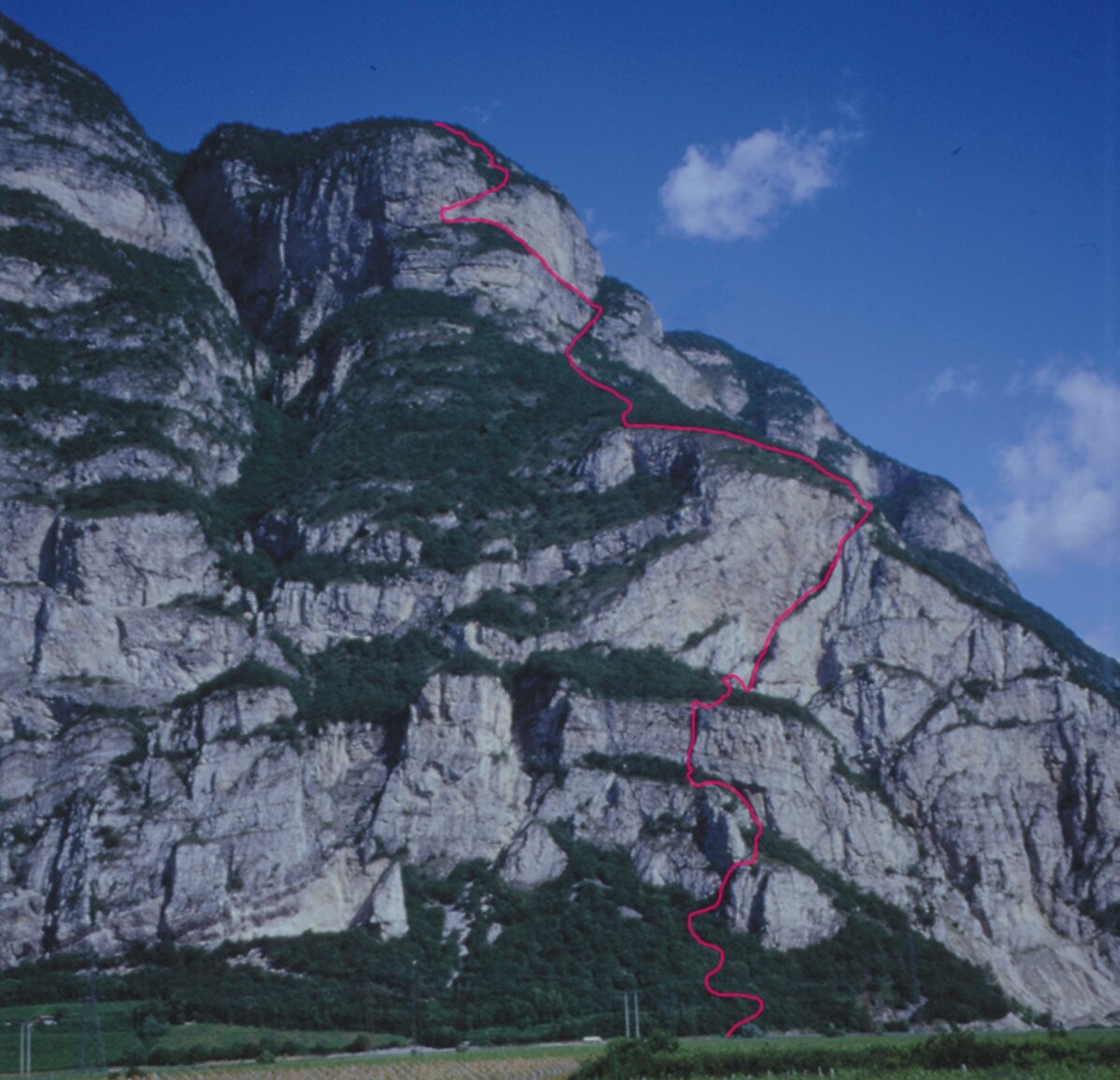
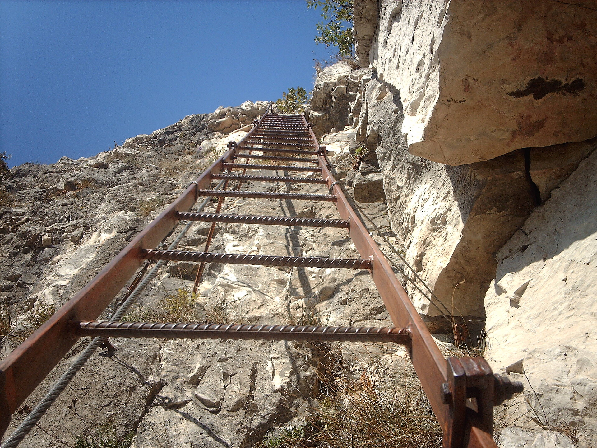
    The via ferrata climbs over the rocky slopes and exposed grassy hills of Lampskopf and Gogelberg to the base of the Pflerscher Tribulaun. It is perfect for climbers who appreciate a combination of nature enjoyment and easy climbing. However, the ascent is physically demanding. Due to the southern exposure, the tour is very sweaty (bring drinks). On the other hand, after rainy days, it is advisable to wait—there is a high risk of slipping!

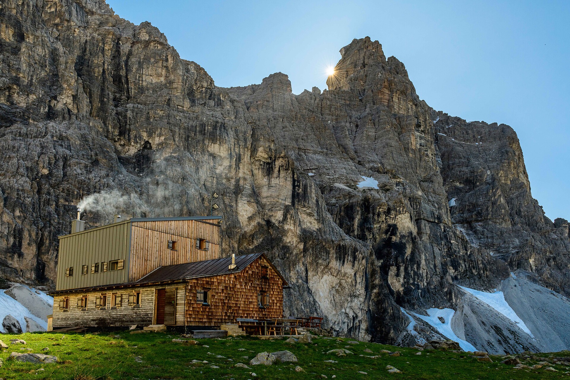
    Start: Parking lot at the bridge after Hinterstein (1380m). From the easternmost farmhouse (signpost for via ferrata), the trail winds uphill to the start of the steel cable (45min). The climb to Lampskopf (1995m; 1.5 hours; approx. 400m elevation) is varied. The ascent continues "via ferrata-free" over steep meadows to Gogelberg (2276m), where another steel cable awaits in the summit area. Shortly after the summit, you will join trail no. 7/32A, which leads you to the Tribulaunhütte (2368m, 1.5 hours from Lampskopf). Descent via the hut approach, trail no. 8 in approx. 2 hours.

    Difficulty: A to B; short sections C;
    Length: Total ascent 1000m, of which 400m + 100m via ferrata
    Time: 3.5 - 4 hours.

    Obtížnost: vysoká
    1053 m nadmořská výška
    3h:30 min doba trvání
    Climbing
    Climbing the Gran Cir peak at sunrise
    Corvara, Dolomites Region Alta Badia

    The first moments of the morning at the top of a peak, when the shy rays of the sun illuminate the surrounding rocks, making them glow a warm orange-gold colour: breathtaking moments that will remain engraved in your heart forever.
    Just outside Colfosco, on the bends of the Gardena pass, you can enjoy the inimitable spectacle of the Dolomite sunrise as you climb the peaks of the Cir group. Of all the possible climbs, that to the summit of the Gran Cir is the least difficult.

    Obtížnost: střední
    0 m nadmořská výška
    2h:04 min doba trvání
    Climbing
    Via Ferrata Rotwand | Roda di Vael
    Welschnofen/Nova Levante, Dolomites Region Eggental

    Technically not very hard, with some difficult spots. Famous for its beautiful scenery and stunning panoramic views.

    Attention: there are some snowfields. For accessibility, mountain experience and the appropriate equipment are required (good hiking boots, hiking poles and possibly crampons).

    Obtížnost: střední
    985 m nadmořská výška
    5h:00 min doba trvání
    Climbing
    Via ferrata "Stuller Wasserfall"
    Moos in Passeier/Moso in Passiria, Meran/Merano and environs

    The via ferrata „Stuller Wasserfall“ is a medium-difficulty-level climb with a very difficult variation in the middle part, which can be bypassed. This steep and exposed climb proceeds through a breathtaking setting in the immediate vicinity of the roaring waterfall.

    The Stuller waterfall is a mighty height of 342 meters consisting of two cascades, and is the third highest in Europe.

    About two thirds of the way through the climb there is the possibility to discontinue the ascent and take a footpath to Stuls or descend to Moos. The final section of the via ferrata can also be undertaken as a short journey from Stuls with access via said footpath.

    The variants V1(E) and V2(F) are extremely difficult and heavily overhanging in many passages!

    Obtížnost: vysoká
    500 m nadmořská výška
    4h:00 min doba trvání
    Climbing
    Pitla Cir (Pitla Cir Peak)
    Sëlva/Selva, Dolomites Region Val Gardena

    The Piccolo Cir is a relatively short via ferrata, but not to be underestimated, and is suitable as
    a half-day tour. 

    Obtížnost: nízká
    415 m nadmořská výška
    1h:28 min doba trvání
    Climbing
    Via Ferrata Avventura in Natura
    Sand in Taufers/Campo Tures, Ahrntal/Valle Aurina

    This Via Ferrata has truely earned the name "Avventura"! Three-rope bridge, Burmabridge, plank bridge or chimes - these are just a few elements that await you on the new Via Ferrata at Speikboden! Beautifully laid out, with many steps and final summit cross, the trail offers a breathtaking view through the Ahrntal valley.

    The wonderful adventure Via Ferrata with difficulty B rounds off the wide climbing offer at Speikboden, along with the Via Ferrata Speikboden (B/C) and the Via Ferrata Kids (A).

    The starting point is at the Station Speikboden Alm at 2.000m, which can be reached by cablecar. After a 30-minute hike on the forest road in direction to Luttach, you reach the entrance of the Via Ferrata Avventura. A total of 10 sections have to be climbed before reaching the summit cross of the mountain "Kleiner Nock". The tour is designed as a circular route, the return path is on the hiking trail no. 18a, back to the starting point.


    Tour details

    • Difficulty: B (moderately difficult), min. age 12 years
    • Start/finish point: Station Speikboden Alm at 2.000m, reachable by cablecar Speikboden
    • Entrance: From the station Speikboden Alm via the forest path A in direction to Luttach, 20 min
    • Ascesa: 350 m in altitude, 3 h
    • Return path to the station Speikboden Alm: path no. 18a, 1 h
    • Time needed in total: min. 3 h 30 min
    • Last descent with the cablecar Speikboden: 5:00 pm (in august: 6:00 pm)
    Obtížnost: střední
    350 m nadmořská výška
    3h:30 min doba trvání
    Climbing
    Via Ferrata Genie in a Bottle Speikboden
    Ahrntal/Valle Aurina, Ahrntal/Valle Aurina

    Suitable for enthusiastic newcomers, a welcoming side event for mountain lovers, exiting for sportive climbers. The via ferrata is of a medium degree of difficulty, starting right after the exit of the  Speikboden gondola at 2.000m. You’ll overcome 350m of difference in altitude belayed and safe. On your first steps out of the gondola you will already get this pure feeling of summits surrounding you. Hold on for the stunning view across Valley Aurina, Zillertal Alps and the white peaks of Durreck. Walk on for the entrance of the via ferrata. Keep the feeling of touching mountains and sky while you step into the via ferrata. Get excited on the super long suspension bridge, get a grip on the edgy rocks of the mountains. You’ll arrive at the very peak of Speikboden. Heading towards a panoramic view you can only here enjoy: Dolomites, Tre Cime and Marmolata towards the glaciers of Valley Aurina. The tour is considered a circular route, for your way back you can either chose the chairlift Sonnklar or hike downwards the alpine paths of the Speikboden recreation area.

    It is possible to rent the equipment for the Via Ferrata at the mountain station of the cablecar Speikboden.


    Obtížnost: střední
    350 m nadmořská výška
    2h:00 min doba trvání
    Mountaineering
    Via Ferrata Fennberg
    Kurtinig an der Weinstraße/Cortina sulla Strada del Vino, Alto Adige Wine Road

    An almost vertical chimney makes the beginning of the via ferrata found 3.8 km south of Margreid. This is followed by rock passageways with brackets, wire ropes and iron ladders. A partially exposed hiking trail leads through scrub forest to the last rock passage (summit book). Then follows a short secured route, until the trail merges into a forest path that leads to the first houses of Unterfennberg. After approx. 300 meters on a paved road, a forest path branches off to the left - marking 3 -. On this you reach the meadow and lake of Unterfennberg (1047 m), where there are two restaurants.

     There are two options for the way back: on the "normal way" (signpost 3) to Margreid and from there either by taxi - taxi Boccher Tel. +39 3356142064 - or on foot about ¾ hour to the starting point. Or from Unterfennberg south following the mark 502 B to Aichholz (Roverè della Luna). From the center on asphalt in a northerly direction about 2 km to your starting point.

     Tip: Do not start too late; the rock walls heat up very fast!

    Obtížnost: střední
    915 m nadmořská výška
    4h:22 min doba trvání
    Climbing
    Via Ferrata Laurenzi
    Kastelruth/Castelrotto, Dolomites Region Seiser Alm

    The Via Ferrata Laurenzi passes over the Molignon ridge, and is one of the most difficult Via Ferrata routes in the Dolomites. A sure foot, a good head for heights and experience are an absolute must, as, in part, it crosses an exceptionally narrow, exposed ridge. From a scenery point of view, this route promises breathtaking views over the Langkofel range, the Sella massif, the Marmolada and down into the Duron Valley below.

    Obtížnost: vysoká
    644 m nadmořská výška
    2h:01 min doba trvání
    Climbing
    Via Ferrata Knott Unterstell
    Naturns/Naturno, Meran/Merano and environs

    Just below the skywalk you find the training- and family via ferrata “KNOTT”. The access and the descent are short, so the via ferrata is easy to reach. The via ferrata "KNOTT" has one short connector route,
    a 20 m long suspended bridge, two steep ladders and four routes. The four routes "Sally", "Turtle", "Affele" and "Rocky" show simple routes, difficult passages, exposed tracks and technical sections.

    Obtížnost: střední
    68 m nadmořská výška
    0h:10 min doba trvání
    Climbing
    Via Ferrata Kids Pirate's Rock Speikboden
    Ahrntal/Valle Aurina, Ahrntal/Valle Aurina

    Gain your first experience on a Via Ferrata! The new Via Ferrata at Speikboden is specially designed for children between 6 and 12 years. Under the motto PIRATES the little ones can learn climbing on routes suitable for children.

    It is possible to rent the equipment for the Via Ferrata at the mountain station of the cablecar Speikboden.

    Obtížnost: nízká
    61 m nadmořská výška
    1h:00 min doba trvání
    Climbing
    Via Ferrata Michl
    Sand in Taufers/Campo Tures, Ahrntal/Valle Aurina

    “Michl” is just waiting for a visit from leisure and beginner climbers. On an easy, B-difficulty course, it can offer a real climbing experience to any visitor with a half-good head for heights. After a little overhang, climbers pull themselves over rock bars that on average remain relatively low. Ideal for practising clicking and changing carabiners. A short hiking route shares the via ferrata in two sections. Small surprise: a stream provides refreshment and a place to rest and let you take in the natural surroundings. And not forgetting your own climbing performance too. After a further climb, at the exit of the via ferrata is one of the loveliest viewing points in the Speikboden area. The little Speikboden lake, a hidden gem, rewards all visitors with a natural spectacle at the conclusion of the climb.

    Anyone who has got the bug for more climbing can hike down the mountain to the start of the Speikboden's “Genie in a Bottle” via ferrata. Climbers who have used “Michl” to warm up will manage well on the next via ferrata.

    Obtížnost: střední
    326 m nadmořská výška
    1h:13 min doba trvání
    Climbing
    Via ferrata Les Cordes
    Badia, Dolomites Region Alta Badia

    The via ferrata Les Cordes, classified as medium to moderate, is a climb with great view points. The via ferrata was built on the edge of the Puez-Odle Nature Park along a centuries-old route.

    Many, many years ago, the farmers of La Villa brought their cows and horses to the Gherdenacia plateau on very steep path. The trail was much steeper and more demanding than all the paths that today lead to the Plateau. The path was called "les cordes" (Ladin for "the ropes").

    In 2019 a via ferrata, also called "Les Cordes", was built along this route. The starting point of the via ferrata can be easily reached with the Gardenaccia chairlift. From the mountain station of the chairlift it is than only about 5 minutes to the start.

    Obtížnost: střední
    238 m nadmořská výška
    0h:39 min doba trvání
    Climbing
    Fixed rope route on the Hochalpenkopf
    Olang/Valdaora, Dolomites Region Kronplatz/Plan de Corones

    A nice excursion in the mountains of the Natural Park of Fanes - Sennes - Braies an Pustertal Valley. The tour starts from the path n.20 of from the foresty road n. 20B up to the alpine refuge Brustalm, which is open for you in summer. From here go on on the path n. 20 in direction Franz Josefhöhe until the Kühwiesenkopf. Now an approvpriate mountain shoe is required to go through the way, that ends at the Kaserkopf. Reach the Hochalpenkopf across a glade toward sud.


    Obtížnost: vysoká
    1670 m nadmořská výška
    5h:43 min doba trvání
    Climbing
    Via ferrata Piz da Lech
    Corvara, Dolomites Region Alta Badia

    This impressive via ferrata (equipped trail) winds through chimneys and crevices, steep passages and two vertical ladder ascents up to a breathtaking summit in the Sella group. The access to the via ferrata is located near the Kostner mountain hut, at the top station of the Vallon lift. The hut can be reached from Corvara with the Boé gondola or on foot with an ascent from the Campolongo pass.

    Obtížnost: střední
    382 m nadmořská výška
    1h:45 min doba trvání
    Mountaineering
    Compatsch – Antermoiasee Lake – Compatsch
    Kastelruth/Castelrotto, Dolomites Region Seiser Alm
    Difficult hike that requires very good physical condition. Good surefootedness, sturdy shoes and alpine experience are necessary.

    The crystal blue Antermoia Lake amidst the barren mountain world of the Dolomites is impressive. There are several refuges along this route that invite you to stop for a bite to eat.
    Obtížnost: vysoká
    1986 m nadmořská výška
    9h:13 min doba trvání
    Climbing
    Via Ferrata Hoachwool
    Naturns/Naturno, Meran/Merano and environs

    Once past the metal suspension bridge, the climbing route leads on over ramps up to the “Hoachwool” where you will see the ancient larch wood channels and trenches of the historic irrigation canals. Then you come to an exposed wall which needs good technique and top physical condition. After this difficult part, an easier passage gives wonderful views of nearby, imposing Juval Castle and the lovely surrounding vegetation. Then, on up a ladder to reach the Wandbuch grotto and the final stretch just beneath the Hofl farmhouse. After reaching the top, follow the fence to the right as far as the railings. Then you have a choice of two ways down. If you want to stay high up and have excellent views of the Norderberg, walk on up to the Unterstell cable-car mountain station (20 min.) and take the cable-car back down into the valley or, if you prefer, walk back down along path no. 10 (1 hour) to the Unterstell cable-car car park.

    Obtížnost: vysoká
    1120 m nadmořská výška
    4h:30 min doba trvání
    Climbing
    Via Ferrata Oskar Schuster
    Sëlva/Selva, Dolomites Region Seiser Alm
    The via ferrata leads over 700 m through steep walls and cirques before you reach the summit at 2,958 m and look down on the Val Gardena valley and the South Tyrolean Dolomites.
    The descent is via the Plattkofel normal trail to the same hut and via the Friedrich August trail back to the Sella Pass.
    Obtížnost: vysoká
    1511 m nadmořská výška
    5h:31 min doba trvání
    Mountaineering
    Climb: Sarner Scharte
    Sarntal/Sarentino, Bolzano/Bozen and environs

    Climbing Route | Sarner Scharte | Sarner Scharte rises to an elevation of 2,468 metres, directly above Val Sarentino/Sarntal Valley | Climb: Sarner Scharte | Starting point: Sarentino/Sarnthein

    Obtížnost: střední
    408 m nadmořská výška
    1h:04 min doba trvání
    1 2 3

      Eine Vielzahl von unterschiedlichen Schwierigkeitsgraden, eine hervorragende Beschilderung und jährlich geprüfte Routen machen diese Form des Kletterns so sicher wie möglich und zum landschaftlichen Erlebnis.