Přeskočit na obsah

přidáno k oblíbeným

odebráno z oblíbených

Jejda! Došlo k problému, zkuste to prosím znovu

Vytváří se váš účet

Váš účet byl úspěšně vytvořen a nyní jste přihlášeni

Jste úspěšně přihlášeni!

Váš účet byl úspěšně vytvořen, ale nepodařilo se nám vás automaticky přihlásit

Jste odhlášeni

Filtr
Vybrané filtry
    Úroveň obtížnosti
    Doba trvání
    Vzdálenost v km

    Nordic walking v Jižním Tyrolsku

    Udržujte se v kondici - s nordic walkingem v Jižním Tyrolsku. Tento sport vyvinutý ve Finsku v sobě spojuje pohyb a radost z přírody, uvolňuje svalové napětí a mimo jiné zlepšuje kardiovaskulární výkonnost. A těm, kteří ještě nezvládli používání holí, je během dovolené v Jižním Tyrolsku k dispozici profesionál, který jim pomůže v parcích pro nordic walking a na túrách s průvodcem. Všichni ostatní se mohou spolehnout na více než 2 000 kilometrů tras pro nordic walking v Jižním Tyrolsku.

    Výsledky
    Running & Fitness
    Nordic Walking Tour 10: "Unterstell"
    Naturns/Naturno, Meran/Merano and environs

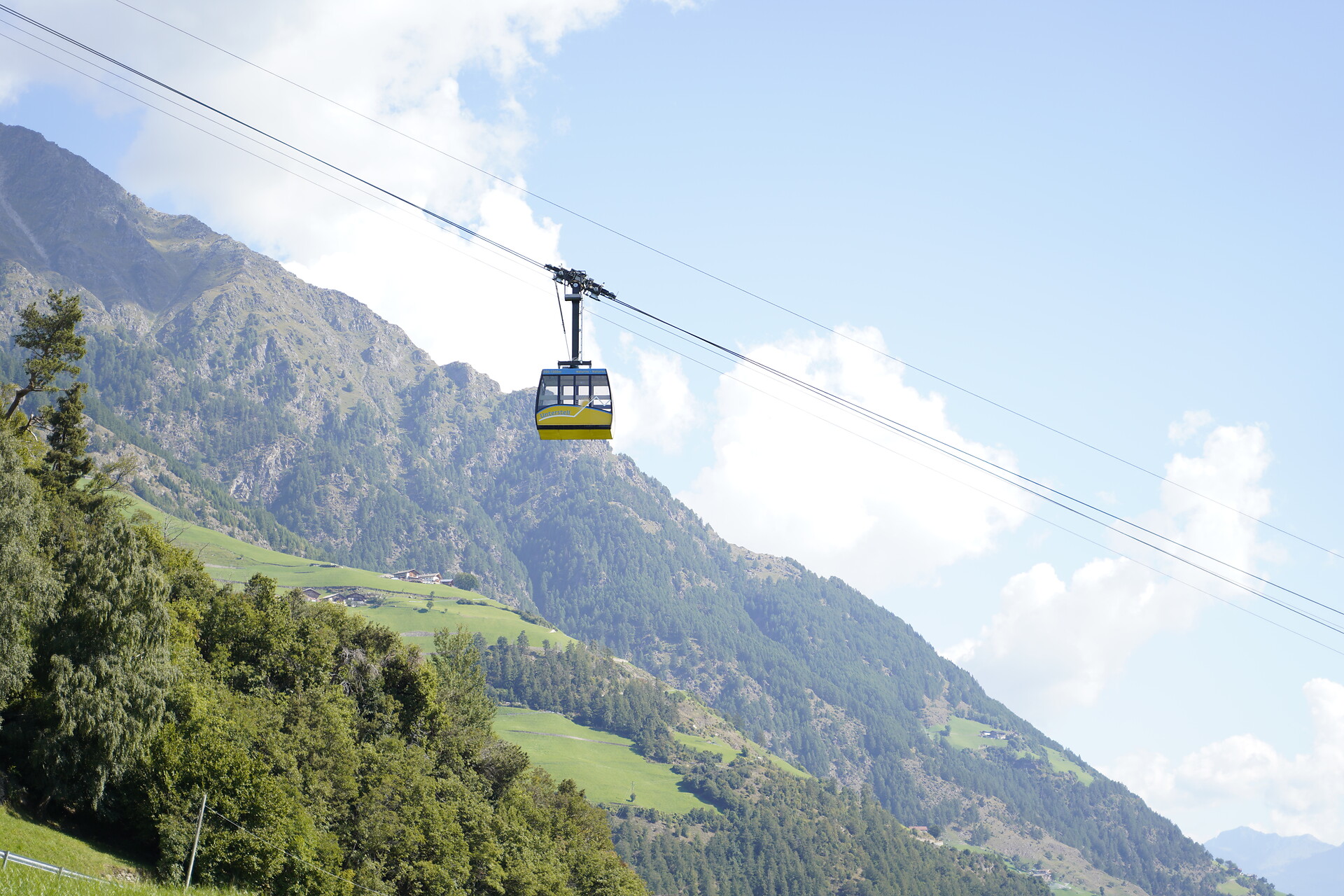
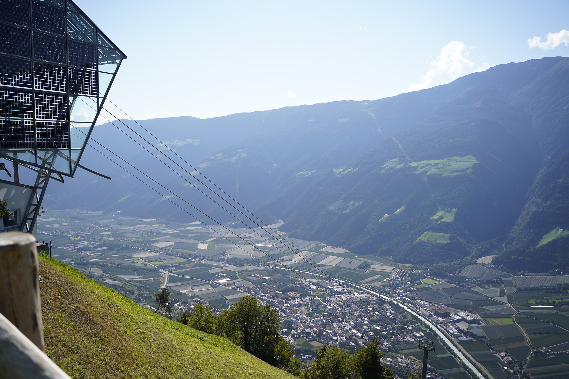
    This route starts at the mountain station of the Unterstell/Naturno cable-car and heads up to the Meraner Höhenweg which it follows in the direction of the Schnals valley as far as the Lindhof. It then leads downwards past Patleid and back to the start again at the Unterstell farm.

    Obtížnost: střední
    187 m nadmořská výška
    0h:40 min doba trvání
    Running & Fitness
    Round track of the Lake of Toblach
    Toblach/Dobbiaco, Dolomites Region 3 Zinnen

    The nordic walk starts at the car park east of Dobbiaco Lake (near Hotel Baur at the Lake) or at the car park west from Dobbiaco Lake (near the Seerestaurant). Make the round track in clockwise direction.

    It is a very breathtaking place where you can see the wildlife.

    An educational path with 11 stations leads around the lake.

    Further information to the water treasures of Dobbiaco: www.three-peaks.info/en/dobbiaco/dobbiaco/experiencing-dobbiaco/lago-di-dobbiaco-and-dobbiaco-water-treasures.html?_ga=1.204887893.455846822.1385385320

    Obtížnost: nízká
    7 m nadmořská výška
    0h:19 min doba trvání
    Leisure & Experience
    Jogging on the Marling Waalweg Trail
    Marling/Marlengo, Meran/Merano and environs

    12 kilometers long, the Marlinger Waalweg trail is a popular hiking and jogging trail which runs along the former irrigation channels, the longest of its kind in South Tyrol.

    Obtížnost: nízká
    160 m nadmořská výška
    0h:49 min doba trvání
    Leisure & Experience
    Well-Fit-Parcour
    Plaus/Plaus, Meran/Merano and environs

    The 1,6 km long Alpine-Well-Fit-Parcour is composed of four stations with suggestions of stretching exercises, mobilization, strengthening- and relaxation exercises, all to help improve your well-being. The parkour runs from the original “well-fit” route between Plaus and Naturno along the bottom of Monte Tramontana. Starting point is at the “Gröbenweg” in Plaus.

    Obtížnost: nízká
    21 m nadmořská výška
    1h:49 min doba trvání
    Running & Fitness
    Jogging route 11
    Naturns/Naturno, Meran/Merano and environs

    This route starts at the Naturno railway station bridge and follows the paved road towards the bridge of Plaus. There it crosses the bridge and follows then the via Gröben towards the forest of Monte Tramontana. There it follows the Rittersteig along the Alpine-Well-Fit-Parcour back to Naturno. Length: 10,2 km. Elevation level at starting point: 544 m. Hight differenc: 229 m.

    Obtížnost: nízká
    184 m nadmořská výška
    2h:30 min doba trvání
    Running & Fitness
    Around the lake Resia
    Graun im Vinschgau/Curon Venosta, Vinschgau/Val Venosta

    The round of the Reschensee is a special experience for hikers and runners. The wonderful views of the Ortler is unique. The tower in the lake completes the picture. He is the last witness of the sunken village of Graun which can live the story.

    Obtížnost: střední
    0 m nadmořská výška
    1h:45 min doba trvání
    Leisure & Experience
    UNESCO Wold Heritage-Ronda
    Sëlva/Selva, Dolomites Region Val Gardena

    From Selva, we run to the parking area in Vallunga and from there past the path no. 14 to the St. Sylvester chapel, and then on through a forest of larches and Swiss stone pines, where we slowly gain elevation and can enjoy the unique panorama of the surrounding Puez-Geisler Nature Park. The valley ends in a large, flat meadow (Pra da Rì), which serves as the turning point of our route.

    Shorter Variant: We run to the St. Sylvester chapel and then turn left there at the way of the cross (path no. 26), follow this and then run over Daunei back to Selva.

    Obtížnost: nízká
    220 m nadmořská výška
    2h:27 min doba trvání
    Running & Fitness
    Sunny Loop in Meransen
    Mühlbach/Rio di Pusteria, Brixen/Bressanone and environs

    Experience the sunny and tranquil atmosphere of Meransen on this varied route. Medium difficulty with breathtaking views of the Pustertal and Eisacktal – perfect for runners with good fitness who love combining sport and nature.

    Obtížnost: střední
    177 m nadmořská výška
    0h:49 min doba trvání
    Running & Fitness
    Nordic Walking: San Genesio - Montoppio
    Jenesien/San Genesio Atesino, Bolzano/Bozen and environs

    From the centre of the village, follow trail no. 33a until you reach the Locher restaurant. From here, walk on along trail nr. 2 until you come to your place of departure. Duration of the excursion: 1 hours and 50 minutes - Drop/rise: 330 m

    Obtížnost: nízká
    378 m nadmořská výška
    2h:38 min doba trvání
    Running & Fitness
    Jogging route 13
    Naturns/Naturno, Meran/Merano and environs

    The trails begin near Nischlhof holiday apartment rental. Then it follows the “Vogeltennpromendade” along the sentiero panoramico on Monte Sole all the way to the “Eichgasse”. Going up towards the restaurant “Wiedenplatzerkeller” it continues on the path “Wallburgweg” until it reaches the intersection at the restaurant “Schwalbennest”. There, it turns downhill passing by Castel “Engelsburg” reaching the starting point. Length: 6,0 km, altitude at starting point: 572m, difference in altitude: 285m

    Obtížnost: střední
    265 m nadmořská výška
    1h:04 min doba trvání
    Running & Fitness
    Circular Route H - St. Georgen
    Schenna/Scena, Meran/Merano and environs
    This easy running route starts at St. Georgen and runs 3 kilometers via the apple orchards and the St. Georgener Straße back to St. Georgen.
    Obtížnost: nízká
    100 m nadmořská výška
    0h:19 min doba trvání
    Running & Fitness
    Nordic Walking Tour 6: "Alter Kirchweg"
    Naturns/Naturno, Meran/Merano and environs

    This track connects the Nordic walking Route in the valley to paths on the slopes of the Sonnenberg mountain. Starting from the Nischlhof farm, the way leads along the Kirchbachgraben to Engelsburg and then up towards the Salten Kirchweg to Höfl and on upwards to the Unterstell farm at 1,300mt. You can then take the Unterstell/Naturno cable-car back to the valley. Please remember to check the cable-car timetable.

    Obtížnost: střední
    762 m nadmořská výška
    1h:28 min doba trvání
    Running & Fitness
    Your Run in Rodeneck
    Rodeneck/Rodengo, Brixen/Bressanone and environs

    Run peacefully through the idyllic landscape of Rodeneck! This short and easy route on the Ywein Trail is perfect for all fitness levels – ideal for recharging and enjoying nature.

    Obtížnost: nízká
    71 m nadmořská výška
    0h:15 min doba trvání
    Running & Fitness
    Nordic Walking Tour 3: "Wallburg"
    Naturns/Naturno, Meran/Merano and environs

    Starting from the Nischlhof farm, the path leads along the Kirchgraben to the bridge near Engelsburg then turns left to the Schwalbennest Jausenstation. It goes on upwards to the crossroads with the Wallburgweg path then along this path to the Wiedenplatzer Keller restaurant and on downwards along an asphalted road to the Sonnenberger Panorama Path. It then follows the Sonnenberger Panorama Path and along the Vogeltenn Promenade back to the starting point

    Obtížnost: střední
    248 m nadmořská výška
    2h:00 min doba trvání
    Running & Fitness
    Nordic Walking in Proveis/Proves
    Proveis/Proves, Meran/Merano and environs

    The Proves/Proveis village center serves as the starting and the finishing line for the course. The quiet and meditative course in the Nordic Walking Park runs through the forest. Difference in altitude: 264 m. The course offers an impressive panoramic view.

    Obtížnost: střední
    189 m nadmořská výška
    1h:13 min doba trvání
    Running & Fitness
    Stocknertal Circular Trail in Terento – Enjoy Nature and Running
    Terenten/Terento, Brixen/Bressanone and environs

    The Stocknertal Circular Trail in Terento is a short and easy running trail through the charming woods near the village center. With a length of 3 km and a mix of asphalt and forest paths, it’s ideal for beginners and anyone looking to combine physical activity with a natural setting.

    Obtížnost: nízká
    104 m nadmořská výška
    0h:54 min doba trvání
    Running & Fitness
    Nordic Walking Tour 8: "Fuchsberg"
    Naturns/Naturno, Meran/Merano and environs

    This path starts from the mountain station of the Unterstell/Naturno cable car and heads upwards to Parleid then on to the Lindhof farm on the Meraner Hichenweg. It then leads up to the Dickhof farm, the highest point of the tour, before heading down towards Kopfron on the Meraner Höhenweg and past Innerunterstell before returning to Patleid and the starting point again.

    Obtížnost: střední
    653 m nadmořská výška
    2h:19 min doba trvání
    Leisure & Experience
    Nordic Walking Rasen
    Rasen-Antholz/Rasun Anterselva, Dolomites Region Kronplatz/Plan de Corones
    From the Recreation Park in Rasun di Sotto through the heart of the village to the curch. From there, take the hiking trail up to the Oberstall Estates. Descend via the road towards Rasun di Sopra to the "House of Culture". Retur via the Mühl Valley towards Rasun di Sotto.
    Obtížnost: nízká
    238 m nadmořská výška
    2h:30 min doba trvání
    Leisure & Experience
    Trail running Puez
    Sëlva/Selva, Dolomites Region Val Gardena
    The Puez circuit is an absolute treat for those who love long trail runs in alpine terrain. We go right at the entrance to the Vallunga, taking the path no. 12 through the Chedul Valley to Creispëina Pass. From the beginning, it’s quite steep, partially in steps, until the valley begins to open and becomes gentler and flatter. From Crespëina Pass we continue over the Dolomite High Path no. 2 to the Rifugio Puez, from there we continue to follow the High Path no. 2 until it diverges in path no. 16, which brings us back to Vallunga.
    Obtížnost: vysoká
    1146 m nadmořská výška
    5h:17 min doba trvání
    Running & Fitness
    Saltaus Irrigation Channel Trail
    Meran/Merano, Meran/Merano and environs

    From the parking lot of the Hirzer cable car station in Saltaus, the way leads down to the Passer causeway and continues to the Torgglerhof Apple Hotel. From there, the trail alongside the old irrigation channel leads up to Schenna – or, after the Waaler hut, in the direction of Riffian and Meran. After about 1.5 hours you reach Meran, from where you can easily take the bus back to Saltaus. Total length: 10 km

    Obtížnost: nízká
    14 m nadmořská výška
    1h:00 min doba trvání
    Running & Fitness
    Nordic walking to the Thermal Baths Innichen / San Candido
    Innichen/San Candido, Dolomites Region 3 Zinnen

    Nordic Walking Moderately difficult, two-hour tour to the ancient healing baths and thermal springs of Innichen / San Candido and the Riese-Haunoldhütte / Rifugio Gigante Baranci refuge, in the middle of the forest. Return possibility by the chairlift.

    Starting point: San Candido, hiking time: 2 hours, difference of level: 300 m

    The chairlift Haunold/Baranci and the Riese-Haunoldhütte / Rifugio Gigante Baranci refuge are open from the end of May until the the beginning of October and from the beginning of December until the end of March.

    Obtížnost: střední
    0 m nadmořská výška
    1h:30 min doba trvání
    Leisure & Experience
    Sassolungo circuit
    Sëlva/Selva, Dolomites Region Val Gardena
    This route circling the Sassolungo massif is a superlative trial run. The beautiful landscape and the breathtaking views will make you forget the physical exertion. The route runs mostly on a constant elevation between approx. 2,200 m and 2,300 m, so that you experience only small changes in elevation.
    Obtížnost: vysoká
    751 m nadmořská výška
    4h:52 min doba trvání
    Running & Fitness
    Circular Route K - Schenner Waalweg path
    Schenna/Scena, Meran/Merano and environs
    This moderately difficult running route starts near the valley station of the Taser cable car and runs 4,5 kilometers along the Schenner Waalweg and the orchards back to the starting point.
    Obtížnost: střední
    200 m nadmořská výška
    0h:34 min doba trvání
    Running & Fitness
    Jogging route 12
    Naturns/Naturno, Meran/Merano and environs

    This route starts at the Naturno railway station bridge and follows the paved road towards the sports grounds. There it turns right and runs on to Cirlano/Tschirland and Stava/Staben. The route returns along the cycle path, all the way to Cirlano bridge, where it then follows the Etschdammweg trail.

    Obtížnost: nízká
    61 m nadmořská výška
    2h:37 min doba trvání
    Running & Fitness
    Nordic Walking St. Walburg/S. Valburga
    Ulten/Ultimo, Meran/Merano and environs

    The starting point of the Nordic Walking Park of S. Valburga/St. Wallburg is located on the Zoggler Stausee reservoir and runs on a consistently smooth path along the lake up to Pracupola/Kuppelwies at the starting point of the technical course (for mastering a solid Nordic Walking technique in 7 steps) as well as the S. Nicolò/St. Nikolaus course. The majority of the path runs through the forest and gravel soil. Difference in altitude: 79 m.

    Obtížnost: nízká
    0 m nadmořská výška
    1h:30 min doba trvání
    Running & Fitness
    Nordic Walking: Schermoos - Salten
    Mölten/Meltina, Bolzano/Bozen and environs

    Starting from the Schermoos parkplace, follow trail no. 7 and then the E5 european long-distance trail to reach the Edelweiss restaurant. Come back to your place of departure walking back on the same trail. Duration of the excursion: 2 hours and 40 minutes - Drop/rise: 290 m

    Obtížnost: nízká
    269 m nadmořská výška
    3h:02 min doba trvání
    Running & Fitness
    Guncina/Guntschna run: 7,1 km
    Bolzano/Bozen, Bolzano/Bozen and environs
    After Ponte Talvera / Talferbrücke, walk direction Gries district and reach the beginning of the Guncina Promenade; the meandering promenade climbs pleasantly among magnificent Mediterranean plants and offers enchanting panoramic views of the entire city. At the end of the walk, cross the San Genesio / Jenesien road very carefully and, having reached the highest point of the route, continue along the Rio Fago Promenade admiring the spectacular waterfall; descend towards Bolzano and return to the starting point along the Talvera Promenade.
    Obtížnost: střední
    200 m nadmořská výška
    1h:40 min doba trvání
    Running & Fitness
    Circular Route L - Tiefenbrunn
    Schenna/Scena, Meran/Merano and environs
    This moderately challenging, partly steep running route starts at the Taser cable car valley station and extends for 3 kilometers along the Ifinger Straße and Verdinser Straße for returning to the starting point.
    Obtížnost: střední
    170 m nadmořská výška
    0h:19 min doba trvání
    1 2 3