Ga meteen naar de inhoud

toegevoegd aan favorieten

verwijderd uit favorieten

Helaas is er een probleem opgetreden. Probeer het opnieuw.

Uw account wordt aangemaakt

Je account is succesvol aangemaakt en je bent nu ingelogd

U bent succesvol ingelogd!

Uw account is succesvol aangemaakt, maar we konden u niet automatisch aanmelden

U bent uitgelogd

Filteren
Geselecteerde filters
    Moeilijkheidsgraad
    Duur
    Afstand in km

    Nordic Walking in Zuid-Tirol

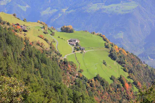
    Blijf in vorm - met Nordic Walking in Zuid-Tirol. Deze in Finland ontwikkelde sport combineert beweging en genieten van de natuur, verlicht onder andere spierspanning en verbetert de cardiovasculaire prestaties. En voor wie het gebruik van de stokken nog niet onder de knie heeft, staat er tijdens de vakantie in Zuid-Tirol in de Nordic Walking parken en op de begeleide tochten een professional klaar om te helpen. Alle anderen kunnen rekenen op meer dan 2.000 kilometer aan paden voor nordic walking in Zuid-Tirol.

    Resultaten
    Running & Fitness
    Circular Route F - upper town
    Schenna/Scena, Meran/Merano and environs
    This simple running route starts at the Schenna mini-golf course and stretches over 3.5 kilometers along Verdinser Straße, Wiesenweg path , and Bloseggweg path.
    Moeilijkheidsgraad: gemakkelijk
    150 m Hoogtemeters
    0h:19 min Duur
    Running & Fitness
    Circular Route J - Salfgut
    Schenna/Scena, Meran/Merano and environs
    This moderately difficult running route starts above the St. Georgen district at Vernaun Castle and runs 5 kilometers along the Schenner Waalweg and Buschenschank Salfgut back to the starting point.
    Moeilijkheidsgraad: gemiddeld
    250 m Hoogtemeters
    0h:45 min Duur
    Running & Fitness
    Circular Route G - Maiser Waalweg
    Schenna/Scena, Meran/Merano and environs
    This moderately difficult running route starts in the center of Schenna at the tourist office and runs 7 kilometers along the Maiser Waalweg and the Mitterplattweg back to Schenna.
    Moeilijkheidsgraad: gemiddeld
    250 m Hoogtemeters
    1h:19 min Duur
    Running & Fitness
    Nature Fitness Park – Nordic Walking in Villabassa/Niederdorf
    Niederdorf/Villabassa, Dolomites Region 3 Zinnen

    Nordic Walking in Villabassa/Niederdorf | For a long time now, Villabassa has focused on preventative health care and wellness. With the Nature Fitness Park, the village has a new facility to add to its range of healthcare services. | Nature Fitness Park – Nordic Walking in Villabassa/Niederdorf | Starting point: Villabassa

    Moeilijkheidsgraad: gemiddeld
    0 m Hoogtemeters
    9h:58 min Duur
    Running & Fitness
    Circular Route G - Vorland
    Schenna/Scena, Meran/Merano and environs
    This easy running route starts at the mini-golf in Schenna and runs 2.5 kilometers via the Kampflkreuz and the Schennaer Straße back to the mini-golf.
    Moeilijkheidsgraad: gemakkelijk
    85 m Hoogtemeters
    0h:15 min Duur
    Leisure & Experience
    Nordic Walking Rasen
    Rasen-Antholz/Rasun Anterselva, Dolomites Region Kronplatz/Plan de Corones
    From the Recreation Park in Rasun di Sotto through the heart of the village to the curch. From there, take the hiking trail up to the Oberstall Estates. Descend via the road towards Rasun di Sopra to the "House of Culture". Retur via the Mühl Valley towards Rasun di Sotto.
    Moeilijkheidsgraad: gemakkelijk
    238 m Hoogtemeters
    2h:30 min Duur
    Leisure & Experience
    Laufrunde: Soltn
    Jenesien/San Genesio Atesino, Bolzano/Bozen and environs

    Running Round at the beautiful larch reported on the "Salto", start finish: Maso Maneggio Edelweiss to albergo Lavena and back! Run lenght: 10,7 km

    Moeilijkheidsgraad: gemakkelijk
    269 m Hoogtemeters
    3h:40 min Duur
    Running & Fitness
    Circular Route A - Village Round
    Schenna/Scena, Meran/Merano and environs
    This easy 1.5-kilometer route starts at the Schenna tourist office and follows the sidewalk along Schlossweg to Verdinser Straße, then back to the starting point.
    Moeilijkheidsgraad: gemakkelijk
    60 m Hoogtemeters
    0h:10 min Duur
    Running & Fitness
    Saltaus Irrigation Channel Trail
    Meran/Merano, Meran/Merano and environs

    From the parking lot of the Hirzer cable car station in Saltaus, the way leads down to the Passer causeway and continues to the Torgglerhof Apple Hotel. From there, the trail alongside the old irrigation channel leads up to Schenna – or, after the Waaler hut, in the direction of Riffian and Meran. After about 1.5 hours you reach Meran, from where you can easily take the bus back to Saltaus. Total length: 10 km

    Moeilijkheidsgraad: gemakkelijk
    14 m Hoogtemeters
    1h:00 min Duur
    Leisure & Experience
    Val Gardena Mountain Run
    Urtijëi/Ortisei, Dolomites Region Val Gardena

    The Val Gardena Mountain Run, one of the most scenic mountain runs in the world, takes place every year in July in Val Gardena. The 14.5 km long route runs from Ortisei over the sleepy hamlet of St. Jacob in the UNESCO World Heritage area Puez-Geisler, and from there to the summit of Ortisei’s “local” mountain, the Seceda. The view which awaits us along the route and at our destination at 2,457 m is simply stunning. The return route can be taken comfortably by cable car.

    Moeilijkheidsgraad: zwaar
    1277 m Hoogtemeters
    4h:54 min Duur
    Running & Fitness
    Circular Route M - Verdins
    Schenna/Scena, Meran/Merano and environs
    This moderately challenging running route starts in Verdins and extends for 4.5 kilometers along the Wiesersteig trail to the Hofweg and the Taser cable car, then down to the Verdinser road, returning to the starting point.
    Moeilijkheidsgraad: gemiddeld
    225 m Hoogtemeters
    0h:30 min Duur
    Running & Fitness
    Circular Route K - Schenner Waalweg path
    Schenna/Scena, Meran/Merano and environs
    This moderately difficult running route starts near the valley station of the Taser cable car and runs 4,5 kilometers along the Schenner Waalweg and the orchards back to the starting point.
    Moeilijkheidsgraad: gemiddeld
    200 m Hoogtemeters
    0h:34 min Duur
    Leisure & Experience
    Nordic Walking Niederrasen - Neunhäusern
    Rasen-Antholz/Rasun Anterselva, Dolomites Region Kronplatz/Plan de Corones

    Upon leaving the Recreation Park in Rasun di Sotto, cross the bridge, turn left, and preceed along the brook to the main road. From here, proceed towards Camping Corones and then pass under and across the main road, continue along Novecase until you reach the Bridge at Valdaora di Sotto, and then turn left and proceed towards Valdaora di Sotto, connecting to the Routes at Olang.

    Moeilijkheidsgraad: gemakkelijk
    30 m Hoogtemeters
    1h:30 min Duur
    Running & Fitness
    Nordic Walking in Proveis/Proves
    Proveis/Proves, Meran/Merano and environs

    The Proves/Proveis village center serves as the starting and the finishing line for the course. The quiet and meditative course in the Nordic Walking Park runs through the forest. Difference in altitude: 264 m. The course offers an impressive panoramic view.

    Moeilijkheidsgraad: gemiddeld
    189 m Hoogtemeters
    1h:13 min Duur
    Running & Fitness
    Nordic Walking: Jenesien - Vorderafing
    Jenesien/San Genesio Atesino, Bolzano/Bozen and environs

    Leave from the local tourist office, follow trail no. 3a until you reach the Unterweg restaurant anf walk the same way to come back. Duration of the excursion: 45 min - Drop/rise: 290 m

    Moeilijkheidsgraad: gemiddeld
    460 m Hoogtemeters
    2h:07 min Duur
    Running & Fitness
    Circular Route I - Vernaun
    Schenna/Scena, Meran/Merano and environs
    This easy running route starts at St. Georgen and runs 3 kilometers via the apple orchards and the St. Georgener Straße back to St. Georgen.
    Moeilijkheidsgraad: gemakkelijk
    100 m Hoogtemeters
    0h:25 min Duur
    Running & Fitness
    Circular Route H - St. Georgen
    Schenna/Scena, Meran/Merano and environs
    This easy running route starts at St. Georgen and runs 3 kilometers via the apple orchards and the St. Georgener Straße back to St. Georgen.
    Moeilijkheidsgraad: gemakkelijk
    100 m Hoogtemeters
    0h:19 min Duur
    Running & Fitness
    Circular Route L - Tiefenbrunn
    Schenna/Scena, Meran/Merano and environs
    This moderately challenging, partly steep running route starts at the Taser cable car valley station and extends for 3 kilometers along the Ifinger Straße and Verdinser Straße for returning to the starting point.
    Moeilijkheidsgraad: gemiddeld
    170 m Hoogtemeters
    0h:19 min Duur
    Running & Fitness
    Round track of the Lake of Toblach
    Toblach/Dobbiaco, Dolomites Region 3 Zinnen

    The nordic walk starts at the car park east of Dobbiaco Lake (near Hotel Baur at the Lake) or at the car park west from Dobbiaco Lake (near the Seerestaurant). Make the round track in clockwise direction.

    It is a very breathtaking place where you can see the wildlife.

    An educational path with 11 stations leads around the lake.

    Further information to the water treasures of Dobbiaco: www.three-peaks.info/en/dobbiaco/dobbiaco/experiencing-dobbiaco/lago-di-dobbiaco-and-dobbiaco-water-treasures.html?_ga=1.204887893.455846822.1385385320

    Moeilijkheidsgraad: gemakkelijk
    7 m Hoogtemeters
    0h:19 min Duur
    Running & Fitness
    Circular Route B - Saltner
    Schenna/Scena, Meran/Merano and environs
    This easy 4-kilometer route starts at the planted flower heart in the center of Schenna and follows Mitterplattweg path to the edge of the village, then returns to the starting point along the sidewalk of Schennaer Straße.
    Moeilijkheidsgraad: gemakkelijk
    100 m Hoogtemeters
    0h:25 min Duur
    Leisure & Experience
    Nordic Walking Oberstall
    Rasen-Antholz/Rasun Anterselva, Dolomites Region Kronplatz/Plan de Corones

    From the Recreation Park in Rasun di Sotto through the heart of the village to the curch. From there, take the hiking trail up to the Oberstall Estates. Descend via the road towards Rasun di Sopra to the "House of Culture". Retur via the Mühl Valley towards Rasun di Sotto.

    Moeilijkheidsgraad: gemakkelijk
    180 m Hoogtemeters
    1h:30 min Duur
    Running & Fitness
    Nordic Walking in Kuppelwies/Pracupola
    Ulten/Ultimo, Meran/Merano and environs

    The parking lot serves as the starting and finishing line (beginning of the Ultner Höfeweg farms hiking trails) in Pracupola/Kuppelwies. A very beautiful course amidst the quaint and idyllic Val d’Ultimo/Ultental Valley leading up to S. Nicoló/St. Nikolaus. On the way back, the path runs along the other side of the valley. Difference in altitude: 251 m. Mostly in the forest. 

    Moeilijkheidsgraad: gemiddeld
    0 m Hoogtemeters
    2h:40 min Duur
    Running & Fitness
    Around the lake San Valentino
    Graun im Vinschgau/Curon Venosta, Vinschgau/Val Venosta

    The lake Haidersee is a natural lake with a biotope areas, lead two boardwalks over which. Signs along the way describe the different bird and fish species in the region.

    Moeilijkheidsgraad: gemakkelijk
    0 m Hoogtemeters
    0h:30 min Duur
    Running & Fitness
    Around the lake Resia
    Graun im Vinschgau/Curon Venosta, Vinschgau/Val Venosta

    The round of the Reschensee is a special experience for hikers and runners. The wonderful views of the Ortler is unique. The tower in the lake completes the picture. He is the last witness of the sunken village of Graun which can live the story.

    Moeilijkheidsgraad: gemiddeld
    0 m Hoogtemeters
    1h:45 min Duur
    Running & Fitness
    Circular Route E - Thurnerhof
    Schenna/Scena, Meran/Merano and environs
    This easy running route starts above Schenna and runs for 1,5 kilometers along the Wiesenweg path to the restaurant Thurnerhof, then returns to the starting point via the Verdinser Straße.
    Moeilijkheidsgraad: gemakkelijk
    55 m Hoogtemeters
    0h:10 min Duur
    Leisure & Experience
    Nordic Walking Redensberg
    Rasen-Antholz/Rasun Anterselva, Dolomites Region Kronplatz/Plan de Corones

    From Rasun di Sotto towards the Camping Corones and continue via the "Dorfrunde" hiking trail to a crossroad. Follow the street to Redensberg and on the hiking trail in direction Mount Hochnall. Go down to the farm Burgfrieden and descend to the hunting hut. Continue to the left following the "Dorfrunde" hiking trail until you reach the Barbecue in Rasun di Sopra. Cross the main street and go back along the river to Rasun di Sopra or Rasun di Sotto.

    Moeilijkheidsgraad: zwaar
    539 m Hoogtemeters
    3h:45 min Duur
    Running & Fitness
    Circular Route D - Castle round
    Schenna/Scena, Meran/Merano and environs
    This easy running route starts at the tourism office Schenna and runs for 2 kilometers along the Schlossweg, Wiesenweg path and the Waldweg path.
    Moeilijkheidsgraad: gemakkelijk
    100 m Hoogtemeters
    0h:19 min Duur
    Running & Fitness
    Bridges tour: 6,3 km
    Bolzano/Bozen, Bolzano/Bozen and environs
    After Ponte Talvera / Talferbrücke, run along the promenade called "Lungo Talvera San Quirino and cross the yellow pedestrian bridge; after a while cross Ponte Loreto and reach the southern bank of the river; walk along the Isarco / Eisack river to the wooden bridge and cross it; continue along the "Passeggiata Lungo Isarco" and pass under Ponte Roma / Rombrücke; run along the beautiful, partly tree-lined meadows until just before Ponte Palermo Brücke. Go back towards Ponte Roma, pass in front of the Lido Swimmingpool and the Druso Stadium and return to the starting point.
    Moeilijkheidsgraad: gemakkelijk
    25 m Hoogtemeters
    1h:37 min Duur
    Running & Fitness
    Running route San Vigilio - Fodara Masaronn
    Al Plan/San Vigilio, Dolomites Region Kronplatz/Plan de Corones

    For all action and adventure passionate, the San Vigilio dolomites region is the place to be: mountain biking and hiking, Nordic-Walking or running are just some of the activities summer holidays in San Vigilio have to offer. From the village square via Valiares follow the trail called “Tres La Val” up to the “Spiaggetta Ciamaor” park. From there following the signs to “Tres La Val” and continue on the right side of the stream to Fodara Masaronn. One-way: 5 km

    Moeilijkheidsgraad: gemiddeld
    224 m Hoogtemeters
    3h:01 min Duur
    1 2 3