
1/3
Running Pleasure in Vals – A Perfect Blend of Nature and Exercise
Valles/Vals, Mühlbach/Rio di Pusteria, Brixen/Bressanone and environs
medium
Obtížnost
164 m
Převýšení
0h:49 min
doba trvání
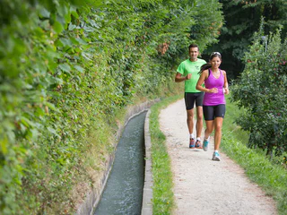
Udržujte se v kondici - s nordic walkingem v Jižním Tyrolsku. Tento sport vyvinutý ve Finsku v sobě spojuje pohyb a radost z přírody, uvolňuje svalové napětí a mimo jiné zlepšuje kardiovaskulární výkonnost. A těm, kteří ještě nezvládli používání holí, je během dovolené v Jižním Tyrolsku k dispozici profesionál, který jim pomůže v parcích pro nordic walking a na túrách s průvodcem. Všichni ostatní se mohou spolehnout na více než 2 000 kilometrů tras pro nordic walking v Jižním Tyrolsku.
1/3
Valles/Vals, Mühlbach/Rio di Pusteria, Brixen/Bressanone and environs
medium
Obtížnost
164 m
Převýšení
0h:49 min
doba trvání

Vallesina/Versein, Mölten/Meltina, Bolzano/Bozen and environs
easy
Obtížnost
269 m
Převýšení
3h:02 min
doba trvání
Pfalzen/Falzes, Dolomites Region Kronplatz/Plan de Corones
easy
Obtížnost
123 m
Převýšení
1h:11 min
doba trvání
San Nicolò/St. Nikolaus, Ulten/Ultimo, Meran/Merano and environs
medium
Obtížnost
0 m
Převýšení
3h:30 min
doba trvání
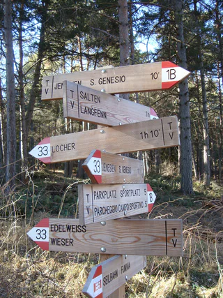
Cologna/Glaning, Jenesien/San Genesio Atesino, Bolzano/Bozen and environs
medium
Obtížnost
460 m
Převýšení
2h:07 min
doba trvání
Scena/Schenna, Schenna/Scena, Meran/Merano and environs
easy
Obtížnost
85 m
Převýšení
0h:15 min
doba trvání
1/2
Nobls/Nobls, Jenesien/San Genesio Atesino, Bolzano/Bozen and environs
easy
Obtížnost
378 m
Převýšení
2h:38 min
doba trvání
Bolzano Centro/Bozen Zentrum, Bolzano/Bozen, Bolzano/Bozen and environs
easy
Obtížnost
25 m
Převýšení
1h:37 min
doba trvání
1/2
Naturno/Naturns, Naturns/Naturno, Meran/Merano and environs
difficult
Obtížnost
1169 m
Převýšení
4h:28 min
doba trvání
Selva/Sëlva/Wolkenstein/Sëlva, Sëlva/Selva di Val Gardena, Dolomites Region Val Gardena
difficult
Obtížnost
969 m
Převýšení
5h:01 min
doba trvání
Videgg/Videgg, Schenna/Scena, Meran/Merano and environs
easy
Obtížnost
150 m
Převýšení
0h:19 min
doba trvání
Rasun di Sopra/Oberrasen, Rasen-Antholz/Rasun Anterselva, Dolomites Region Kronplatz/Plan de Corones
easy
Obtížnost
30 m
Převýšení
1h:30 min
doba trvání
1/3
Naturno/Naturns, Naturns/Naturno, Meran/Merano and environs
medium
Obtížnost
248 m
Převýšení
2h:00 min
doba trvání
Cologna/Glaning, Jenesien/San Genesio Atesino, Bolzano/Bozen and environs
easy
Obtížnost
321 m
Převýšení
2h:31 min
doba trvání

1/2
Terento/Terenten, Terenten/Terento, Brixen/Bressanone and environs
easy
Obtížnost
104 m
Převýšení
0h:54 min
doba trvání
1/2
Naturno/Naturns, Naturns/Naturno, Meran/Merano and environs
medium
Obtížnost
653 m
Převýšení
2h:19 min
doba trvání
Merano/Meran, Meran/Merano, Meran/Merano and environs
easy
Obtížnost
14 m
Převýšení
1h:00 min
doba trvání
Scena/Schenna, Schenna/Scena, Meran/Merano and environs
easy
Obtížnost
60 m
Převýšení
0h:10 min
doba trvání
Naturno/Naturns, Naturns/Naturno, Meran/Merano and environs
easy
Obtížnost
61 m
Převýšení
2h:37 min
doba trvání
1/2
Naturno/Naturns, Naturns/Naturno, Meran/Merano and environs
medium
Obtížnost
762 m
Převýšení
1h:28 min
doba trvání
Selva/Sëlva/Wolkenstein/Sëlva, Sëlva/Selva di Val Gardena, Dolomites Region Val Gardena
medium
Obtížnost
250 m
Převýšení
2h:17 min
doba trvání
San Giorgio/St. Georgen - Scena/Schenna, Schenna/Scena, Meran/Merano and environs
easy
Obtížnost
100 m
Převýšení
0h:19 min
doba trvání
Naturno/Naturns, Naturns/Naturno, Meran/Merano and environs
medium
Obtížnost
627 m
Převýšení
3h:12 min
doba trvání
San Giorgio/St. Georgen - Scena/Schenna, Schenna/Scena, Meran/Merano and environs
medium
Obtížnost
200 m
Převýšení
0h:34 min
doba trvání
Rasun di Sopra/Oberrasen, Rasen-Antholz/Rasun Anterselva, Dolomites Region Kronplatz/Plan de Corones
easy
Obtížnost
180 m
Převýšení
1h:30 min
doba trvání
1/5
Selva/Sëlva/Wolkenstein/Sëlva, Sëlva/Selva di Val Gardena, Dolomites Region Val Gardena
difficult
Obtížnost
751 m
Převýšení
4h:52 min
doba trvání
Scena/Schenna, Schenna/Scena, Meran/Merano and environs
easy
Obtížnost
55 m
Převýšení
0h:10 min
doba trvání
1/3
S.Benedetto/Nauders, Rodeneck/Rodengo, Brixen/Bressanone and environs
easy
Obtížnost
71 m
Převýšení
0h:15 min
doba trvání
1/3
Marlengo/Marling, Marling/Marlengo, Meran/Merano and environs
easy
Obtížnost
160 m
Převýšení
0h:49 min
doba trvání

1/2
Terento/Terenten, Terenten/Terento, Brixen/Bressanone and environs
medium
Obtížnost
279 m
Převýšení
2h:40 min
doba trvání


