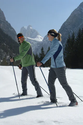
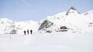
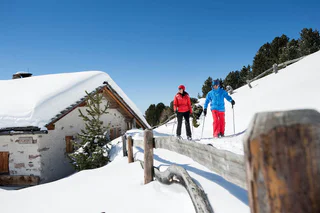
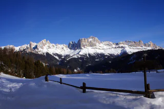
Przejdź do treści

dodano do ulubionych

usunięto z ulubionych

Coś poszło nie tak! Wystąpił problem. Spróbuj ponownie

Twoje konto jest właśnie tworzone

Twoje konto zostało pomyślnie utworzone i jesteś teraz zalogowany

Zalogowałeś się pomyślnie!

Twoje konto zostało pomyślnie utworzone, ale nie mogliśmy zalogować Cię automatycznie

Jesteś wylogowany

Filtr
Wybrane filtry
    Poziom trudności
    Czas trwania
    Odległość w km

    Wędrówki na rakietach śnieżnych w Południowym Tyrolu

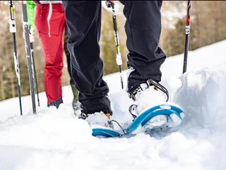
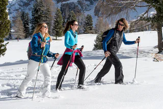
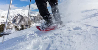
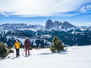
    Wędrówki na rakietach śnieżnych w Południowym Tyrolu to świetny sposób na poznanie nietkniętej przyrody, spektakularnych widoków Dolomitów i radości z bycia aktywnym. Rodzinne wycieczki na rakietach śnieżnych po łagodnych zboczach czekają na wczasowiczów, podobnie jak strome podejścia na alpejskie szczyty lub wędrówki do przytulnych schronisk górskich. Propozycje najlepszych wycieczek w rakietach śnieżnych w Południowym Tyrolu dostępne są tutaj.
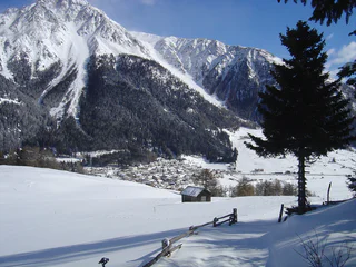
    Wyniki
    Hiking
    Winter Hike to the Stone Men
    Vöran/Verano, Meran/Merano and environs

    The “Stoanerne Mandln“ stone men are located atop a remarkable knoll on Alpine pasture and tower at an elevation of 2,000 metres. Human figures made of stone such as these can also be found in other parts of South Tyrol: they served as a landmark frequently or were simply built by shepherds to pass the time.

    Poziom trudności: trudny
    741 m wysokość w górę
    5h:19 min czas trwania
    Hiking
    Snowshoe-hike tour: Wahlen/San Silvestro - Lachwiesen hut
    Toblach/Dobbiaco, Dolomites Region 3 Zinnen

    Wonderful snowshoe hike above Toblach/Dobbiaco. The Lachwiesen hut is known for its traditional food and for this is worth a visit.

    IMPORTANT: Before starting any ski tour/snowshoe excursion, you must check the weather conditions and danger avalanches report (https://avalanche.report), asking also experts (alpine guides etc.).

    Poziom trudności: średni
    394 m wysokość w górę
    1h:30 min czas trwania
    Hiking
    Snowshoe hike Passenalmen Lappago/Lappach
    Vintl/Vandoies, Ahrntal/Valle Aurina

    Dear snowshoe hikers:
    Because of their favourable location, negligible risk of avalanches and the large number of users the following hiking tips are suitable at all times.  Please be careful after heavy fresh snowfall or in extreme weather. Always:  Check the avalanche status report and the weather forecast. Unless the walks are circular walks, all descriptions are only for the outbound stretch.
    Do not leave the paths.  For the benefit of the wildlife that already struggles in winter, please avoid making loud noises.
    If you are unsure of anything, please ask your host or Tourist Information.

    Appealing winter tour through pine mixed forest in snowy altitudes. Refreshments Malga Bergmeisteralm.

    Poziom trudności: łatwy
    352 m wysokość w górę
    4h:00 min czas trwania
    Hiking
    Snowshoe: Schussriedl/ Cima dei Colesei
    Sexten/Sesto, Dolomites Region 3 Zinnen
    The area around the Kreuzberg Pass and the Sesto Alpine pastures is a true paradise for snowshoe hikers and ski tourers.

    Lawinenbericht/ Reporto Valanghe/ Avalanche forecast
    www.lawinen.report
    Poziom trudności: łatwy
    160 m wysokość w górę
    2h:45 min czas trwania
    Hiking
    Hiking in the winter on the panorama way
    Ritten/Renon, Bolzano/Bozen and environs

    From the vally station cablecar Corno del Renon, the parking area in “Pemmern” (1.541 m) we take the cable car to the Schwarzseespitze (2.070 m). There we follow the indication “Panoramaweg” beginning on the right. The famous “Round Table” an the "Dolomitoskop" are created by the artist “Franz Messner”. You will enjoy the fantastic panorama to the Dolomites (UNESCO–world natural heritage).

    Poziom trudności: łatwy
    112 m wysokość w górę
    1h:43 min czas trwania
    Hiking
    Snowshoe-hiking tour: Ratsberg/Monte Rota - Mellaten/Melate
    Gsies/Valle di Casies, Dolomites Region 3 Zinnen

    The snowshoe hike on the sunny side of Toblach/Dobbiaco offers a beatiful view over the Höhlensteintal/Landro valley and the Toblach/Dobbiaco lake.

    IMPORTANT: Before starting any ski tour/snowshoe excursion, you must check the weather conditions and danger avalanches report (https://avalanche.report), asking also experts (alpine guides etc.).

    Poziom trudności: łatwy
    251 m wysokość w górę
    3h:00 min czas trwania
    Hiking
    Winter Hike in the Altfasstal Valley near Meransen
    Mühlbach/Rio di Pusteria, Brixen/Bressanone and environs

    This winter hike through Altfasstal Valley combines nature and relaxation. The path leads past snowy alpine meadows and sunny resting spots – ideal for families and nature lovers looking to enjoy the peaceful winter landscape.

    Poziom trudności: łatwy
    258 m wysokość w górę
    1h:36 min czas trwania
    Hiking
    Snowshoe-hiking tour: Misurina - Popena valley
    Sexten/Sesto, Dolomites Region 3 Zinnen

    Moderate snowshoe-hike amid the impressive snowy mountain scenery in the middle of the Cristallo-Group.

    IMPORTANT: Before starting any ski tour/snowshoe excursion, you must check the weather conditions and danger avalanches report (https://avalanche.report), asking also experts (alpine guides etc.).


    Poziom trudności: średni
    400 m wysokość w górę
    2h:30 min czas trwania
    Snowshoe Hikes
    Snowshoe Tour: To the Mountain Hoher Mann in the Val Casies Valley (2593m)
    Gsies/Valle di Casies

    A beautiful panorama tour across the Aschtalm, Pfinnhütten, Pfinnscharte and Hoher Mann

    Starting point: Head of the valley in St. Magdalena in the Val Caises Valley (1465 m)
    Descent: back via the ascent route
    Hiking time: ca. 3 ½ hours
    Level of difficulty: easy ski mountain that requires some endurance
    Altitude difference: 1100 m
    Slope exposure: south + east

    Poziom trudności: średni
    1100 m wysokość w górę
    3h:30 min czas trwania
    Snowshoe Hikes
    Snowshoe Tour: Rotlahner in the Val Casies Valley (2748 m)
    Gsies/Valle di Casies

    The “Rotlahner” – an easy but famous ski mountain in the Gsieser Alps

    Starting point: Head of the valley in St. Magdalena in the Gsieser Valley 1465 m
    Descent: back via the ascent route
    Hiking time: 3 ½ hours
    Level of difficulty: medium to difficult; with the exception of two steep slopes (one just beneath the Kasermähder Alm and the other in the area of the Heimwaldjoch) there are no considerable technical difficulties concerning the route
    Altitude difference: 1270 m
    Slope exposure: mainly southwest slopes

    Poziom trudności: średni
    1270 m wysokość w górę
    3h:30 min czas trwania
    Hiking
    Snowshoe hike Malga Kofler/Kofleralm Alpine Farm
    Ahrntal/Valle Aurina, Ahrntal/Valle Aurina

    Snow-shoe walks | Explore the pristine nature of Riva di Tures/Rein in Taufers (1,600 m) on this snowshoe hike. An easy, 90-minute snowshoe hike on Trail No. 9: it is ideal for inexperienced hikers and families as well. | Snowshoe Hike to Kofleralm Alpine Farm | Slope orientation: North | Starting point: Knuttenalm alpine farm parking area | Highest point: 2.034

    Poziom trudności: średni
    0 m wysokość w górę
    3h:00 min czas trwania
    Hiking
    Snowshoe hike to the Buselineck-Monte Nigra in Welschnofen | Nova Levante
    Welschnofen/Nova Levante, Dolomites Region Eggental
    This varied snowshoe hike begins at Frommeralm hut and leads through snowy forest landscapes and over gentle hills to the so-called "Buselineck-Monte Nigra." This is a wooded hill in Welschnofen | Nova Levante that offers a fantastic panorama of the Rosengarten |Catinaccio. Along the way, you pass the Schillerhof hut and then reach the historic wolf pit and the small Lengeria Chapel before descending to Welschnofen | Nova Levante. Throughout the hike, you are continually greeted with impressive views of the surrounding mountain ranges and the expansive valley.
    Poziom trudności: łatwy
    140 m wysokość w górę
    2h:51 min czas trwania
    Snowshoe Hikes
    Snowshoe tour: Forcella di Casies in Val Casies (2205m)
    Gsies/Valle di Casies

    Snowshoe tour on old paths

    Starting point: Val Casies / S. Maddalena head of the valley (1465m)
    Distance: 6,1 km
    Descent: along the ascending route
    Walking time: 02:30 h
    Difficulty: difficult
    Difference in altitude: 740 m
    Information: also feasible with touring skis | southern exposure

    Poziom trudności: średni
    740 m wysokość w górę
    2h:30 min czas trwania
    Snowshoe Hikes
    Snowshoe tour: To the Mountain Salzla a Tesido (2131m)
    Welsberg-Taisten/Monguelfo-Tesido

    With a view towards the Dolomites

    Starting point: parking lot at Tesido above the Mudler mountain farm (1620m)
    Distance: 6,1 km
    Descent: circular hike
    Walking time: 04:00 h
    Difficulty: medium
    Difference in altitude: 525 m
    Information: also feasible with touring skis

    Poziom trudności: łatwy
    517 m wysokość w górę
    1h:55 min czas trwania
    Hiking
    Snowshoe hike Rinsbachalmen Lappago/Lappach
    Mühlwald/Selva dei Molini, Ahrntal/Valle Aurina

    Dear snowshoe hikers:
    Because of their favourable location, negligible risk of avalanches and the large number of users the following hiking tips are suitable at all times.  Please be careful after heavy fresh snowfall or in extreme weather. Always:  Check the avalanche status report and the weather forecast. Unless the walks are circular walks, all descriptions are only for the outbound stretch.
    Do not leave the paths.  For the benefit of the wildlife that already struggles in winter, please avoid making loud noises.
    If you are unsure of anything, please ask your host or Tourist Information.

    Attractive snow hike through magnificent high forest  just below the tree line, rocky mountainscape as far as the eye can see.
    No Refreshments. 

    Poziom trudności: łatwy
    448 m wysokość w górę
    4h:00 min czas trwania
    Hiking
    Snowshoe hike Eggespitz Lappago/Lappach
    Mühlwald/Selva dei Molini, Ahrntal/Valle Aurina

    Dear snowshoe hikers:
    Because of their favourable location, negligible risk of avalanches and the large number of users the following hiking tips are suitable at all times.  Please be careful after heavy fresh snowfall or in extreme weather. Always:  Check the avalanche status report and the weather forecast. Unless the walks are circular walks, all descriptions are only for the outbound stretch.
    Do not leave the paths.  For the benefit of the wildlife that already struggles in winter, please avoid making loud noises.
    If you are unsure of anything, please ask your host or Tourist Information.

    Attractive summit with fantastic panoramic view across Lappago at 2187 m in Val di Cesa. Refreshments: Malga Bergmeisteralm

    Poziom trudności: średni
    545 m wysokość w górę
    5h:00 min czas trwania
    Hiking
    Winter panoramic Hike for Fit Hikers
    Hafling/Avelengo, Meran/Merano and environs

    Another much-loved winter hiking trail starts out in Hafling/Avelengo, passes the Wurzer Alm and Vöraner Alm Mountain Huts, continues on to Kreuzjöchl and then across the snowy pass from Vöran/Verano to Hafling above the timberline.

    Poziom trudności: średni
    928 m wysokość w górę
    5h:49 min czas trwania
    Hiking
    Snowshoe-hiking tour: Kandellen/Gandelle - Bonner hut
    Toblach/Dobbiaco, Dolomites Region 3 Zinnen

    The Bonner hut (closed in winter), which is located at 2,340 m above the sea level, offers a view of the snow-covered Dolomite peaks. Among them also the famous Three Peaks.

    IMPORTANT: Before starting any ski tour/snowshoe excursion, you must check the weather conditions and danger avalanches report (https://avalanche.report), asking also experts (alpine guides etc.).

    Poziom trudności: średni
    711 m wysokość w górę
    2h:30 min czas trwania
    Hiking
    Snowshoeing on Cima Lasta/Astjoch
    Kiens/Chienes, Dolomites Region Kronplatz/Plan de Corones

    The snowshoe hike on the Cima Lasta/Astjoch Peak (2,194 m) is one of the most rewarding things to do in the area. The magnificent summit view of the surrounding mountains is simply impressive.

    Before you start for a snowshoe hike you should always consult the avalanche and weather report!

    Poziom trudności: średni
    713 m wysokość w górę
    4h:00 min czas trwania
    Snowshoe Hikes
    Snowshoe Tour: Along the Taistner Unterrain
    Welsberg-Taisten/Monguelfo-Tesido

    Tranquil low mountain hike – clockwise through meadows and woods of the Taistner Unterrain

    Starting point: crossroad 100 m after the Hotel Alpen Tesitin in Taisten
    Altitude difference: 260 m
    Hiking time: 2 to 3 hours
    Level of difficulty: easy and ideal terrain for snowshoe hiking
    Important: Orientation in forest difficult when leaving marked path
    Please note: this is only a snowshoe hike
    Rest point: mountain restaurant Mudler Hof

    Poziom trudności: łatwy
    315 m wysokość w górę
    2h:10 min czas trwania
    Hiking
    The Three-mountain-huts winter hike
    Hafling/Avelengo, Meran/Merano and environs

    The Three-Alpine-Farms Hike, which leads to three different alpine farms, affords fabulous views as it leads hikers through the plateau’s unique winterlandscape and past the Bruggen Pond.

    Poziom trudności: średni
    629 m wysokość w górę
    4h:34 min czas trwania
    Hiking
    Snowshoe hike Furtalm Riva di Tures/Rein in Taufers
    Sand in Taufers/Campo Tures, Ahrntal/Valle Aurina

    Dear snowshoe hikers:
    Because of their favourable location, negligible risk of avalanches and the large number of users the following hiking tips are suitable at all times.  Please be careful after heavy fresh snowfall or in extreme weather. Always:  Check the avalanche status report and the weather forecast. Unless the walks are circular walks, all descriptions are only for the outbound stretch.
    Do not leave the paths.  For the benefit of the wildlife that already struggles in winter, please avoid making loud noises.
    If you are unsure of anything, please ask your host or Tourist Information.

    Peaceful hike to the pasture at the confluence of Rio Riva and Rio Ursprung. Refreshments: Refreshment stop Angerer.

    Poziom trudności: średni
    249 m wysokość w górę
    4h:00 min czas trwania
    Hiking
    Snowshoe hike Eggemoaralm
    Mühlwald/Selva dei Molini, Ahrntal/Valle Aurina

    Dear snowshoe hikers:
    Because of their favourable location, negligible risk of avalanches and the large number of users the following hiking tips are suitable at all times.  Please be careful after heavy fresh snowfall or in extreme weather. Always:  Check the avalanche status report and the weather forecast. Unless the walks are circular walks, all descriptions are only for the outbound stretch.
    Do not leave the paths.  For the benefit of the wildlife that already struggles in winter, please avoid making loud noises.
    If you are unsure of anything, please ask your host or Tourist Information.

    Beautiful viewpoint high above Selva dei Molini at 1977 m, on the left side heading into the valley.  Accessible by bus from the Sportplatz (playing fields) stop or the Fuchsfalle restaurant. Refreshments: Sportbar

    Poziom trudności: średni
    803 m wysokość w górę
    6h:00 min czas trwania
    Hiking
    Snowshoe-hike tour: Frondeigen/Franadega - Golfen/Monte Calvo
    Toblach/Dobbiaco, Dolomites Region 3 Zinnen

    This snowshoe hike leads up to the Golfen/Monte Calvo, which offers a 360 ° panorama of the snow-covered Dolomite peaks in the south and the Alps in the north.

    IMPORTANT: Before starting any ski tour/snowshoe excursion, you must check the weather conditions and danger avalanches report (https://avalanche.report), asking also experts (alpine guides etc.).

    Poziom trudności: średni
    838 m wysokość w górę
    2h:30 min czas trwania
    Hiking
    Snowshoe hike to the Frin meadows at Karersee | Carezza
    Welschnofen/Nova Levante, Dolomites Region Eggental

    This magnificent panoramic snowshoe hike leads across the picturesque alpine area of the Frin meadows and offers breathtaking views of the Rosengarten | Catinaccio and Latemar. Along the way, you’ll enjoy fascinating panoramic views of the vast snow-covered meadows and the surrounding Dolomite peaks. On the plateau, you'll find numerous "Schupfen," traditional private alpine huts. These give the area a unique, charming, and authentic character. The Frin meadows are a special place where you can fully enjoy the peace and quiet of nature.

    Poziom trudności: łatwy
    330 m wysokość w górę
    2h:31 min czas trwania
    1 2 3 4 5 6 7 8