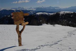
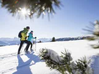
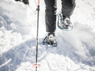
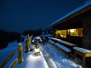
Ga meteen naar de inhoud

toegevoegd aan favorieten

verwijderd uit favorieten

Helaas is er een probleem opgetreden. Probeer het opnieuw.

Uw account wordt aangemaakt

Je account is succesvol aangemaakt en je bent nu ingelogd

U bent succesvol ingelogd!

Uw account is succesvol aangemaakt, maar we konden u niet automatisch aanmelden

U bent uitgelogd

Filteren
Geselecteerde filters
    Moeilijkheidsgraad
    Duur
    Afstand in km

    Sneeuwschoenwandelen in Zuid-Tirol

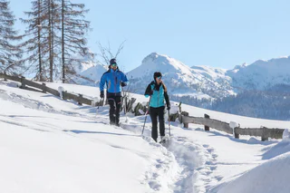
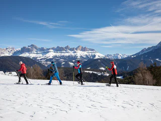
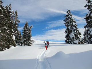
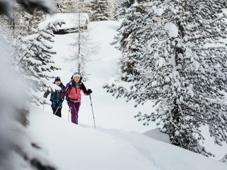
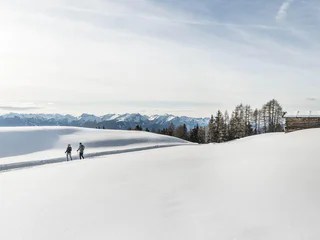
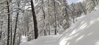
    Sneeuwschoenwandelen in Zuid-Tirol is een geweldige manier om de ongerepte natuur, spectaculaire uitzichten over de Dolomieten en het plezier van actief bezig zijn te ervaren. Gezinsvriendelijke sneeuwschoentochten langs glooiende hellingen wachten op vakantiegangers, net als steile beklimmingen van Alpentoppen of wandelingen naar gezellige berghutten. Suggesties voor de beste sneeuwschoenwandelingen in Zuid-Tirol vind je hier.

    Resultaten
    Snowshoe Hikes
    Ski tour trail
    Sexten/Sesto, Dolomites Region 3 Zinnen

    The Sesto ski touring trail teaches you everything you need to know for safe ski touring during a tour lasting just under two hours. The ski touring trail combines basic theoretical knowledge, for example about the correct behaviour in the event of an avalanche, with an almost six-kilometre tour on which around 540 metres in altitude have to be conquered. The ski touring trail, which is equipped with information boards, starts behind the Zin Fux restaurant and leads between trees and across meadows to the Rotwand. From there to the mountain station, the uphill kick turn is practised in open terrain before returning to the valley via the ski slope.

    Moeilijkheidsgraad: gemakkelijk
    93 m Hoogtemeters
    1h:21 min Duur
    Snowshoe Hikes
    Snowshoe Tour: Rotlahner in the Val Casies Valley (2748 m)
    Gsies/Valle di Casies

    The “Rotlahner” – an easy but famous ski mountain in the Gsieser Alps

    Starting point: Head of the valley in St. Magdalena in the Gsieser Valley 1465 m
    Descent: back via the ascent route
    Hiking time: 3 ½ hours
    Level of difficulty: medium to difficult; with the exception of two steep slopes (one just beneath the Kasermähder Alm and the other in the area of the Heimwaldjoch) there are no considerable technical difficulties concerning the route
    Altitude difference: 1270 m
    Slope exposure: mainly southwest slopes

    Moeilijkheidsgraad: gemiddeld
    1270 m Hoogtemeters
    3h:30 min Duur
    Snowshoe Hikes
    Snowshoe Tour: To the Mountain Hoher Mann in the Val Casies Valley (2593m)
    Gsies/Valle di Casies

    A beautiful panorama tour across the Aschtalm, Pfinnhütten, Pfinnscharte and Hoher Mann

    Starting point: Head of the valley in St. Magdalena in the Val Caises Valley (1465 m)
    Descent: back via the ascent route
    Hiking time: ca. 3 ½ hours
    Level of difficulty: easy ski mountain that requires some endurance
    Altitude difference: 1100 m
    Slope exposure: south + east

    Moeilijkheidsgraad: gemiddeld
    1100 m Hoogtemeters
    3h:30 min Duur
    Snowshoe Hikes
    Snowshoe Tour: Along the Taistner Unterrain
    Welsberg-Taisten/Monguelfo-Tesido

    Tranquil low mountain hike – clockwise through meadows and woods of the Taistner Unterrain

    Starting point: crossroad 100 m after the Hotel Alpen Tesitin in Taisten
    Altitude difference: 260 m
    Hiking time: 2 to 3 hours
    Level of difficulty: easy and ideal terrain for snowshoe hiking
    Important: Orientation in forest difficult when leaving marked path
    Please note: this is only a snowshoe hike
    Rest point: mountain restaurant Mudler Hof

    Moeilijkheidsgraad: gemakkelijk
    315 m Hoogtemeters
    2h:10 min Duur
    Snowshoe Hikes
    Snowshoe tour: To the Pfinnhütten huts in the Val Casies Valley (2152m)
    Welsberg-Taisten/Monguelfo-Tesido

    Panoramic snowshoe tour passing by the Aschtalm hut

    Starting point: Val Casies / S. Maddalena head of the valley (1465m)
    Distance: 7,5 km
    Descent: along the ascending route
    Walking time: 04:00 h
    Difficulty: difficult
    Difference in altitude: 687 m

    Moeilijkheidsgraad: gemiddeld
    663 m Hoogtemeters
    2h:16 min Duur
    Snowshoe Hikes
    Winter hiking trail Lazaun
    Schnals/Senales, Vinschgau/Val Venosta

    A beautiful winter hiking tour on the Lauzaun plateau (2,430 m. a.s.l). Here you are rewarded with a fantastic view of several 3,000 m peaks.

    Moeilijkheidsgraad: gemakkelijk
    24 m Hoogtemeters
    1h:00 min Duur
    Snowshoe Hikes
    Snowshoe Hike Rittner Horn
    Ritten/Renon, Bolzano/Bozen and environs

    The snowshoe hike begins at the Schwarzseespitze, the mountain station of the Bergbahn Rittner Horn cable car.

    Route: take trail no. 19 to the Unterhornhaus inn and continue on the gently ascending trail to the highest point, the Rittner Horn, which is especially popular in winter due to the many hours of sunshine that can be enjoyed here.

    Tip: travel from Bolzano/Bozen to Soprabolzano/Oberbozen on the Rittner Seilbahn cable car. Continue on the Rittner Bahn narrow-gauge railway to Collalbo/Klobenstein. Continue on bus 166 to the valley station of the Rittner Horn cable car.

    Moeilijkheidsgraad: gemakkelijk
    351 m Hoogtemeters
    1h:28 min Duur
    Mountaineering
    Königsanger
    Feldthurns/Velturno, Brixen/Bressanone and environs
    Start: Garner Wetterkreuz (1,430 m)
    Destination: Königsanger (2,436 m)
    Refreshment stop: Radlseehütte (2,284 m)
    Trail no. 10 & trail no. 10A
    Moeilijkheidsgraad: gemiddeld
    0 m Hoogtemeters
    2h:45 min Duur
    Mountaineering
    San Kassian Peak
    Sarntal/Sarentino, Brixen/Bressanone and environs

    The hike starts at the Kühhof car park above Latzfons. Head northwest on forest trail over the open Alpine meadows passing through sparse larch and pine forests to the Klausner Hütte mountain hut (1923 m). Continue along the hiking trail passing the Rungger Hütten huts and Plankenbach brook. Also known as the Kreuzweg (Way of the Cross), the trail then crosses a pine forest before winding its way up a steep slope to the pilgrimage church and mountain shelter at Latzfonser Kreuz. Continue up trail no. 9. Finally, the route leads to the Kassiansee mountain lake and the Kassianspitze summit (2581 m) slightly beyond. The return is back the same way as the ascent.

    Moeilijkheidsgraad: gemiddeld
    0 m Hoogtemeters
    9h:48 min Duur
    Snowshoe Hikes
    Winter hiking trail to Gerstgras
    Schnals/Senales, Vinschgau/Val Venosta

    Walking along snowy meadows, through romantic larch forests in winter silence - all you can hear is the crunching of your feet. Follow the well-marked and traced path and discover the beauty of the rear Schnalstal Valley. Depending on the snow situation, snowshoes are recommended.

    Moeilijkheidsgraad: gemakkelijk
    272 m Hoogtemeters
    3h:15 min Duur
    Snowshoe Hikes
    Snowshoe tour: To the Mountain Salzla a Tesido (2131m)
    Welsberg-Taisten/Monguelfo-Tesido

    With a view towards the Dolomites

    Starting point: parking lot at Tesido above the Mudler mountain farm (1620m)
    Distance: 6,1 km
    Descent: circular hike
    Walking time: 04:00 h
    Difficulty: medium
    Difference in altitude: 525 m
    Information: also feasible with touring skis

    Moeilijkheidsgraad: gemakkelijk
    517 m Hoogtemeters
    1h:55 min Duur
    Snowshoe Hikes
    Snow shoes walking at the Cima Lasta
    Kiens/Chienes, Dolomites Region Kronplatz/Plan de Corones

    The ample meadows on the Cresta di Luson-Lüsner Kamm plateau offer a never-ending choice of hiking routes. This particularly stunning one from the hamlet Elle-Ellen up to Cima Lasta-Astjoch (2147 m) boasts a number of unrivalled panoramic views. The hike/snow-shoe hike is among the most rewarding in this part of South Tyrol: The views from the peak out onto the surrounding mountains are simply unforgettable.

    Moeilijkheidsgraad: gemiddeld
    698 m Hoogtemeters
    3h:07 min Duur
    Snowshoe Hikes
    Snow Shoe Trail mountain pasture Lafetz
    Schnals/Senales, Vinschgau/Val Venosta

    The mountain pasture Lafetz lies on 2,015 m a.s.l in the middle of a magnificent natural landscape. There you will be rewarded with an exclusive view of the Similaun, the Ötztal Alps and the place of discovery Ötzi.

    Moeilijkheidsgraad: gemiddeld
    489 m Hoogtemeters
    2h:12 min Duur
    Snowshoe Hikes
    Snow shoe hiking tour to the Plattner Spitze
    Mühlwald/Selva dei Molini, Dolomites Region Kronplatz/Plan de Corones
    Easy alpine pasture and summit hike. A marvellous tour with magnificent panoramic views.
    AVS awareness campaign for ski tours and snowshoe hikes:
    https://tippthek.info/t/tvkiens#/category/2544
    Moeilijkheidsgraad: gemakkelijk
    839 m Hoogtemeters
    4h:30 min Duur
    Mountaineering
    Monte di Villandro/Villanderer Berg
    Villanders/Villandro, Brixen/Bressanone and environs

    This hike takes you past Totenkirchl Chapel and picturesque Totensee Lake to the peaks of Villandro (Villanderer) Mountain.

    Moeilijkheidsgraad: gemiddeld
    839 m Hoogtemeters
    5h:37 min Duur
    Snowshoe Hikes
    Snowshoe Tour: Forcella di Casies/Gsieser Törl in S. Maddalena/Gsieser Tal Valley
    Gsies/Valle di Casies

    Snowshoe tour: The “Gsieser Törl” – over centuries a strategic passage for man and beast: pilgrims, smugglers, pedlars, hunters, shepherds, as well as the odd lover…

    Starting point: Head of the valley in St. Magdalena in the Gsieser Valley 1465 m
    Descent: back via the ascent route, from Kradorfer Alm left turn is also possible
    Hiking time: 2 ½ hours
    Level of difficulty: moderate to difficult; technical difficulties are minor; but last part of the climb is steep
    Altitude difference: 745 m

    Moeilijkheidsgraad: gemiddeld
    740 m Hoogtemeters
    2h:30 min Duur
    Snowshoe Hikes
    Snowshoe tour: Forcella di Casies in Val Casies (2205m)
    Gsies/Valle di Casies

    Snowshoe tour on old paths

    Starting point: Val Casies / S. Maddalena head of the valley (1465m)
    Distance: 6,1 km
    Descent: along the ascending route
    Walking time: 02:30 h
    Difficulty: difficult
    Difference in altitude: 740 m
    Information: also feasible with touring skis | southern exposure

    Moeilijkheidsgraad: gemiddeld
    740 m Hoogtemeters
    2h:30 min Duur
    Snowshoe Hikes
    Snowshoe tour: To the Schuier Alm in Val Casies Valley (1958m)
    Gsies/Valle di Casies

    Snowshoe tour with a panoramic view

    Starting point: Val Casies Valley/ Colle Hotel Stoll (1255m)
    Distance: 5 km
    Descent: along the ascending route
    Walking time: 03:0 h
    Difficulty: difficult
    Difference in altitude: 733 m

    Moeilijkheidsgraad: gemiddeld
    717 m Hoogtemeters
    2h:28 min Duur
    Snowshoe Hikes
    Snow Shoe Trail mountain pasture Klosteralm
    Schnals/Senales, Vinschgau/Val Venosta

    According to oral tradition, after the dissolution of the Carthusian monastery of Allerengelsberg in 1782, the farmed Alpine pastures of Klosteralm at 2,152 m became the property of a number of families in Certosa/Karthaus who set up a syndicate which has thirty members today. The farm was only accessible by a narrow mountain path until a transport cable car was built in 1959. Thanks to the avalanche barrier beneath the Kreuzspitze, a road link was provided as an “ancillary benefit”. Due to its steep and stony pastures, the farm has been used almost exclusively as a typical farm for young cattle.

    Moeilijkheidsgraad: gemiddeld
    301 m Hoogtemeters
    1h:16 min Duur
    Snowshoe Hikes
    Snow Shoe Trail mountain pasture Mastaun
    Schnals/Senales, Vinschgau/Val Venosta

    The mountain pasture Mastaun is also temporarily managed in winter. It is located in the high mountain valley of the same name, the Maustaun Valley, and belongs to the farmstead Mastaunhof, which is one of the largest farms in the Schnalstal Valley in terms of area. There are some indications that several centuries ago the mountain pasture was still a farm that was inhabited all year round.

    Moeilijkheidsgraad: gemiddeld
    301 m Hoogtemeters
    1h:16 min Duur
    Snowshoe Hikes
    Skitour Vallunga – Nature Park Puez-Odle
    Corvara, Dolomites Region Val Gardena

    The entrance to the Langental valley is located in Selva Gardena and runs through a pleasant walking and hiking path with views of the Stevia massif and the walls of the Puezgruppe on the left, as well as the Chedul Mountains and Col Turond on the right. Along the path you can find the mystical Silester Chapel.

    Moeilijkheidsgraad: gemakkelijk
    182 m Hoogtemeters
    0h:58 min Duur
    Snowshoe Hikes
    Snow shoes walking at the Sambock
    Pfalzen/Falzes, Dolomites Region Kronplatz/Plan de Corones

    Superb hiking options along the ample ridge leading up to Monte Sommo-Sambock and a singular 360° view down onto Brunico-Bruneck, the Dolomites and the Zillertal Alps.

    Moeilijkheidsgraad: gemiddeld
    887 m Hoogtemeters
    4h:00 min Duur
    Snowshoe Hikes
    Snowshoe Tour: To the Mountain Hochkreuzspitze in Val Casies (2739m)
    Gsies/Valle di Casies

    The classic Val Casies Valley ski and snowshoe hike through the Pfoital and to the Hochkreuzspitze

    Starting point: Head of the valley in St. Magdalena in the Gsieser Valley 1465 m
    Hiking time: 4 ½ hours
    Level of difficulty: moderate – difficult; for average skiers, the route offers a wide and open terrain with only a few steep slopes that only require extra caution following fresh snow
    Altitude difference: 1274 m
    Slope exposure: southwest

    Moeilijkheidsgraad: gemiddeld
    1274 m Hoogtemeters
    4h:30 min Duur
    Snowshoe Hikes
    Snow Shoe Trail mountain pasture Bergl
    Schnals/Senales, Vinschgau/Val Venosta

    The untouched Lagauntal, one of the most beautiful valleys in South Tyrol, and the mountain pasture Bergl are also a popular place of excursions in winter. You hike through a snowy, idyllic high mountain landscape with extensive larch forests.

    Moeilijkheidsgraad: gemiddeld
    284 m Hoogtemeters
    2h:46 min Duur
    Snowshoe Hikes
    Snow shoe hiking tour at the Putzenhöe
    Kiens/Chienes, Dolomites Region Kronplatz/Plan de Corones

    The Fundres/Pfunders massif offers a wide range of hiking options with anything from soft-rolling hills to steep slopes leading up to craggy peaks. Gorgeous excursions for both summer-time hikers and winter sports fans – all topped off by breath-taking 360° panoramic views.

    Moeilijkheidsgraad: gemiddeld
    980 m Hoogtemeters
    5h:30 min Duur
    Snowshoe Hikes
    Winter hiking trail Texel
    Schnals/Senales, Vinschgau/Val Venosta

    Hiking along white meadows, past over ancient farmsteads, in the midst of winter silence - all you can hear is the crunching of your feet. Follow the well-marked and prepared winter hiking trail in Madonna di Senales. Depending on the snow situation, snowshoes are recommended.

    Moeilijkheidsgraad: gemakkelijk
    0 m Hoogtemeters
    0h:22 min Duur
    1 2 3 4 5 6 7 8