Südtirol Guide App Logo
Skip to content

added to favourites

removed from favourites

Oops! Something went wrong. Try again

Your account is being created

Your account has been successfully created and you are now logged in

You’ve been logged in successfully!

Your account was created successfully, but we couldn't log you in automatically

You are logged out.

Filter
Selected filters
    Level of difficulty
    Duration
    Distance in KM

    Cycling in the South of South Tyrol

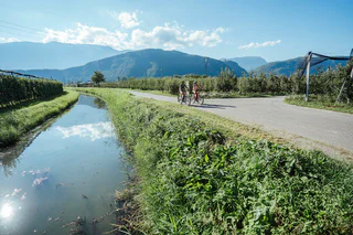
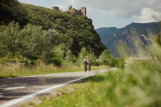
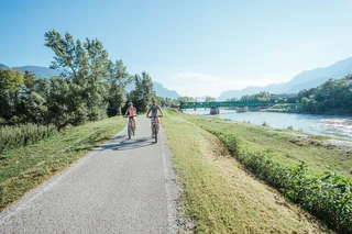
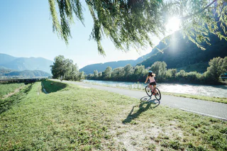
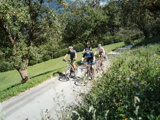
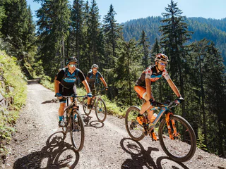
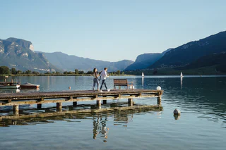
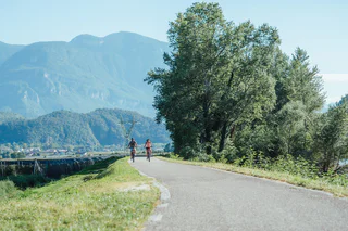
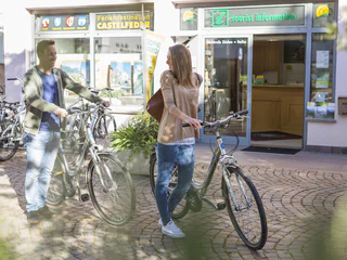
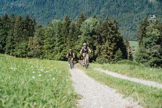
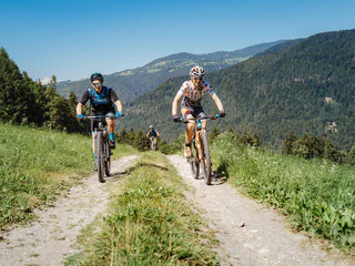
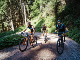
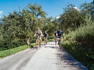
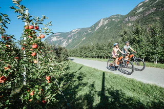
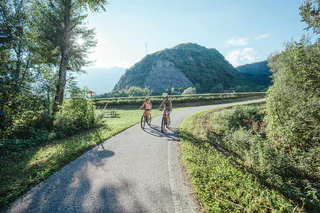
    You can travel long distances on a bike, feel a sense of freedom and warm up for the best adventures. Experience the thrill of discovering new places on two wheels in the south of South Tyrol, where the cycling season starts as early as March. If you are a hardened cyclist, you’ll have your best time cycling on mountain roads and on the valley cycle route. You’ll surely find a wealth of family-friendly excursions through South Tyrol’s unique cultural landscape and if you hop on the e-bike, you’ll probably travel even further.

    Results
    E-MTB
    Sellaronda MTB tour - anti-clockwise
    Corvara, Dolomites Region Alta Badia

    Spectacular Dolomite peaks and legendary mountain passes: The Sellaronda is one of the most beautiful and popular circular routes in the Alps and offers all kinds of exciting options in winter or in summer. One of these is the Sellaronda mountain biking tour. The tour requires a good level of physical fitness and mountain biking experience, because there are some tricky climbs and a few difficult descents to manage. However, for the last few years there has been the option of avoiding some of the particularly steep climbs by using lifts, making it possible to complete the tour in a day.

    Following the Sellaronda MTB Tour Anti-Clockwise there is a total height difference of about 1.020 m to be cycled uphill and several descents through single trails or forest roads. Therefore it is more suited to those who enjoy cycling uphill on your MTB or e-bike. The time needed to complete the tour varies according the ability of the biker: from a minimum 6 to a maximum of 9 hours, with a lunch break included.

    www.sellaronda-mtb.com

    Difficulty: difficult
    3370 m elevation gain
    55 Km distance
    E-MTB
    Stuanbruch-Trail
    Partschins/Parcines, Meran/Merano and environs
    Route length in km: 10,9
    Vertical climb: ascent 100m – descent 1.260m
    Surface: forest path, root passages, stones, loose stones, steep to very steep, cart path, loose stones, no banister or railings, fencing
    Required technical skills: S1/S2 – moderately difficult with some difficult sections
    Difficulty: medium
    36 m elevation gain
    10.1 Km distance
    Bikeparks & Pumptracks
    Pumptrack Naturns
    Naturns/Naturno, Meran/Merano and environs

    Pumptracks are popular meeting spots for kids, teens, and adults.

    In October 2025, an pumptrack was built in Naturno. The pumptrack in Naturno is located near the tennis and beach volleyball courts. Like all the pumptracks, it is asphalted and marked with directional signage that must be followed for safety reasons.

    A pump track is a purpose-built track for cycling. It has a circuit of rollers, banked turns and features designed to be ridden completely by riders "pumping"—generating momentum by up and down body movements, instead of pedaling or pushing. It was originally designed for the mountain bike and BMX scene, and now, due to concrete and/or asphalt constructions, is also used for skateboarding, and accessible to wheelchairs. Pump tracks are relatively simple to use and cheap to construct, and cater to a wide variety of rider skill levels.

    Difficulty: null
    0 m elevation gain
    0.0 m distance
    Downhills
    Furcia Trail
    Al Plan/San Vigilio, Dolomites Region Kronplatz/Plan de Corones

    The Herrnsteig trail's little brother too is packed with flow and curves. But while it's nowhere near as wild and bumpy, its 124 bends and turns between the top of Mount Kronplatz and Passo Furcia make it at least equally winding and dizzying. To get back up to the top, simply hop on the Ruis cable car at Passo Furcia. The big challenge on this trail is to master it without pedalling and with as little use of the brakes as possible. It is ideal for medium-advanced and pro bikers who wish to get to most out of an active riding style.

    Difficulty: medium
    0 m elevation gain
    4.9 Km distance
    Bikepark
    Gardenaccia Freeride Biking Route
    Badia, Dolomites Region Alta Badia
    Freeriding is one of the most adrenaline-pumping ways to ride a bike. Mountain bikes are used to descend mountain paths with bumps, jumps and various natural obstacles such as roots, stones and bushes.
    In the Gardenaccia Freeride Bike Park, starting from the mountain station of the Gardenaccia chairlift at an altitude of 1,750 m, two routes have been created:
    - the first, more difficult route, is for bikers who already have good riding skills and looking for a real adrenaline rush.
    - the second is easier and suitable for less experienced bikers.
    The start of the bike park can be reached by taking the Gardenaccia chairlift from La Villa.
    At the Gardenaccia chairlift there is the possibility to rent freeride bikes.
    0 m elevation gain
    0.0 m distance
    E-Bikes
    Klapfberg Valley
    Ulten/Ultimo, Meran/Merano and environs
    The route starts at the farm Falschauer and leads along a forest road to the Klapfberg alpine hut (1.946 m), which is open from mid-June to early September.
    Difficulty: medium
    599 m elevation gain
    5.8 Km distance
    E-Bikes
    S. Pietro in Valle - Pontives
    Lajen/Laion
    Start in St. Peter im Tal at the Maringerhof. The trail leads through the forest in the direction of Pontives. Along the way are the ice springs, where the beer from the former brewery of St. Peter im Tal used to be stored. After a short climb we reach the Unterspisserhof farm and soon the Pontives craft zone. From there we can also go to St. Peter and in the future also to Ortisei.
    Difficulty: easy
    168 m elevation gain
    2.2 Km distance
    Bikepark
    Jump Area Gassl
    Olang/Valdaora, Dolomites Region Kronplatz/Plan de Corones

    Right next to the valley station of the Olang 1+2 gondola lift in Gassl – where the Gassl Trail ends – a special highlight awaits all biking enthusiasts: the Jump Area Gassl.

    This area impresses with a variety of exciting features: three drops, one kicker, a dirt jump kicker, and a kicker with airbag landing offer adrenaline and action for all skill levels.

    An 80-metre-long conveyor belt takes riders and bikes effortlessly back to the starting point – for endless biking fun without the uphill effort.

    And the best part: the Gassl Bar at the valley station is just around the corner and offers a spacious sun terrace for relaxing and watching the action.

    Difficulty: null
    0 m elevation gain
    0.0 m distance
    E-MTB
    Cycle tour to the Fiechtalm
    Ulten/Ultimo, Meran/Merano and environs
    The route starts directly at the Weißbrunn Lake and leads in a slight ascent over the forest road to the Fiechtalm, which is open from the beginning of June to the end of October.
    Difficulty: medium
    188 m elevation gain
    3.3 Km distance
    E-MTB
    293 Wuhnleger Lake tour
    Tiers am Rosengarten/Tires al Catinaccio, Dolomites Region Seiser Alm

    Witnesses to the event recall the air-raid of 1943 which created the small lake at the Wuhnleger. It is now home to toads, salamanders and dragonflies, and showcases an immense biodiversity. The view of the Catinaccio and the Torri del Vajolet together with their mirror-image in the lake is an unmissable natural spectacle.

    Difficulty: easy
    405 m elevation gain
    11.0 Km distance
    E-Bikes
    Cicling route Monguelfo - Brunico
    Bruneck/Brunico, Dolomites Region Kronplatz/Plan de Corones
    On two wheels through the Pustertal Valley! Explore part of the Pustertal Valley cycle route in a relaxed manner. From Monguelfo to Brunico by bike.
    Start: Monguelfo-Tesido – Monguelfo, village
    Destination: Brunico
    Distance: 17,9 km
    Difference in altitude: 73 m
    Difficulty: easy
    144 m elevation gain
    17.9 Km distance
    Bikeparks & Pumptracks
    MTB Skill Area
    Olang/Valdaora, Dolomites Region Kronplatz/Plan de Corones

    Since summer 2022 you can visit the new MTB Skill Area in Oberolang! 

    There you will find an approx. 500 m long natural trail with many different practice elements for beginners & kids.

    In addition, the MTB Skill Area is located directly next to the Kids World and leads past the panoramic route of the Pustertal Valley Cycle Route.

    A small uphill trail rounds it all off.

    The company Mountain Bike Movements from Innsbruck has realized many new skills:


    SKILLS

    • 2 x bumps
    • 2 x jumps
    • 2 x Up&Down
    • 2 x Up&Steps


    COURSE DETAILS

    • 40 m high level
    • Uphill section
    • 5 switchbacks
    • 2 x small berm
    • Nature trail section
    • Easy Downhill section
    • Difficult Downhill section
    • Rockgarden


    We would like to thank the administration B.N.R. Oberolang for providing the space and the two shapers Ale and Davide who helped us start the process.

    0 m elevation gain
    0.0 m distance
    E-MTB
    Uphill Trumser Alb'l
    Kastelbell-Tschars/Castelbello-Ciardes, Vinschgau/Val Venosta
    Uphill Trumser Alb'l from Kastelbell - marvellous panoramic views guaranteed.
    Difficulty: medium
    1567 m elevation gain
    15.1 Km distance
    E-Bikes
    Large Überetsch Unterland (lowlands) tour
    Eppan an der Weinstaße/Appiano sulla Strada del Vino, Alto Adige Wine Road

    The bike trail goes trough the wine villages Eppan, Kaltern, Tramin and Kurtatsch up to the country frontier at Salurn on traffic-calmed streets. The tour is appropriate for all kinds of bycicles, but is the most fun to ride on e-bikes or racing bikes.

    The route starts at Eppan and leads on the cycle path and the lake loop road to the Kalterer lake and onwards to Tramin. Towards the village you’ll find a rise. Take it and follow the Weinstraße until you reach Margreid and Kurtinig. In all of those villages you’ll find plenty of possibilities to stop for a bite to eat.

    Arriving at Salurn, change the downhill side and follow the hillslope until you come to Laag. From there you can take the cycle path along the Etsch in a northward direction up until the spot where the rivers Etsch and Eisack are meeting. There you turn left and follow the old railway track of the Überetscher railway until the initial point in Eppan.

    Difficulty: medium
    676 m elevation gain
    70.9 Km distance
    Downhills
    Dragon Trail
    Olang/Valdaora, Dolomites Region Kronplatz/Plan de Corones
    New in summer 2022 in the Bike Park Kronplatz is the "Dragon Trail": the trail, over 2 kilometers long, winds along the hillside from the summit to the middle station of the Olang 1+2 lift. The highlight is definitely crossing the Dragon's Head and the Dragon's Tail, where you have a beautiful panorama of the surrounding Dolomites at the same time.
    Difficulty: easy
    0 m elevation gain
    2.0 Km distance
    Downhills
    Spitzhorn Trail
    Olang/Valdaora, Dolomites Region Kronplatz/Plan de Corones
    The Spitzhorn Trail is divided into three sections: the first part, which breaks off from the Gassl Trail, is a sequence of very smooth flowing curves, the middle section features jumps and features in an open area with great visibility to the scenic Wallride. The last section runs through the forest, alternating between natural terrain and various wooden footbridges that eventually lead back to the existing trail.
    Difficulty: medium
    0 m elevation gain
    1 Km distance
    Bikepark
    Brixen Bikepark
    Brixen/Bressanone, Brixen/Bressanone and environs
    Brixen Bikepark on the Plose has four mountain bike trails varying from very easy to challenging. Three of the four descents were only opened in 2018. They were designed by Gravity Logic, which was founded by the legendary trail building team behind Whistler Mountain Bike Park in Canada. All the trails are superbly maintained, boast some fantastic corners and offer plenty of airtime and riding challenges.
    4 lines: 2 difficult, 1 medium, 1 easy
    Accessibility: Plose gondola lift, Palmschoß chairlift
    0 m elevation gain
    0.0 m distance
    Downhills
    Gassl Trail
    Olang/Valdaora, Dolomites Region Kronplatz/Plan de Corones

    The easiest trail in the Kronplatz family: Launched in mid-2015, it winds down the eastern face of the mountain from the middle station Olang 1+2 lift over countless bends all the way down to Casola-Gassl. Although it’s chock-full of easy jumps and low-banked curves, its ever-changing route layout won’t distract you from appreciating the stunning panoramic views – a perfect place to whip up an appetite for freeriding!

    Difficulty: medium
    0 m elevation gain
    6.4 Km distance
    Cycling
    Weinstraße - Vino 50
    Margreid an der Weinstraße/Magrè sulla Strada del Vino, Bolzano/Bozen and environs
    The Weinstraße Vino 50 runs through a beautiful wine region with gentle hills and vineyards. Along the way, there are wineries and places to stop for a break. The route is ideal for those who want to combine nature and enjoyment.
    Difficulty: medium
    172 m elevation gain
    41.6 Km distance
    Downhills
    Crazy Bunny Line
    Al Plan/San Vigilio, Dolomites Region Kronplatz/Plan de Corones

    With plenty of jumps, bumps and bends in quick succession, this line is an “up-in-the-air” variant along the Furcia trail. If you’re not afraid to let go of the brakes and take off, you’re in for tons of fun on this trail.

    Level: medium

    Difficulty: medium
    0 m elevation gain
    491.0 m distance
    Bikeparks & Pumptracks
    Pumptrack
    Burgstall/Postal, Meran/Merano and environs

    A pumptrack is a closed-loop circuit with wave-shaped elements and curves, where speed is generated not by pedalling, but through controlled up-and-down body movements – known as “pumping.”

    The pumptrack facility, newly built in September 2025 in Burgstall, offers riding fun and training opportunities for beginners, enthusiasts and professionals alike. The track allows for playful improvement of riding technique and encourages active outdoor recreation.

    A wide range of sports equipment can be used on the track, including mountain bikes, BMX bikes, scooters, balance bikes and roller skates.

    In addition to promoting balance, coordination and motor skills, the pumptrack also serves as a popular meeting place for people of all ages who enjoy physical activity.

    Appropriate protective gear should be worn at all times, and mutual respect among users is essential.

    Difficulty: null
    0 m elevation gain
    0.0 m distance
    E-MTB
    MTB tour to the Kirchberg Valley
    Ulten/Ultimo, Meran/Merano and environs
    The route starts in St. Gertraud (bus stop) and leads along a forest road to the Kirchberg Alm (1,887 m), which is managed from mid-June to early September and continues to Bärhapp (2,296 m). There the forest road ends and the route continues via hiking trail no. 108 to Rabbijoch.
    Difficulty: medium
    1071 m elevation gain
    8.5 Km distance
    E-MTB
    Schloss Annenberg Tour (Castello di S. Anna)
    Latsch/Laces, Vinschgau/Val Venosta

    This challenging uphill trip to S. Martino in Monte runs from Laces over some loose cobble and up some steep paths and involve some areas where the bike must be pushed. The maximum gradient is 24% and therefore this trail is only recommended for experienced mountain bikers.

    Difficulty: medium
    1167 m elevation gain
    13.4 Km distance
    Mountain bike
    Brixen Bikepark: Jerry Line
    Brixen/Bressanone, Brixen/Bressanone and environs

    The Jerry Line is really easy. Jerry, the creator of the line who also gave it its name, has never designed it too steep, never too rough and never to tight: It is simply ideal for beginners and kids. There are only 300 metres of difference in elevation from the trailhead to the trail end, but in between are 4.2 km trail fun for the whole family.


    Level of difficulty: Green – very easy
    Novice-friendly line with soft bends and flowing route. There are no artificial obstacles or jumps, the line is also suitable for children. Basic knowledge of mountain bikes required.

    Difficulty: easy
    5 m elevation gain
    4.2 Km distance
    Cycling
    Bike route Val Casies/Gsiesertal Valley
    Gsies/Valle di Casies
    The bike route begins in the center of the village of Monguelfo, along the banks of the Casies stream in the valley. You ride along the old Casies valley road to the hamlet of Planca di Sopra, where you cross the main road. From here you continue along the Talblickweg path and the hamlet of Steinegge to St. Martin, crossing the main road again before the sports field; from here you ascend to the Talschlusshütte hut in St. Magdalena. Return along the same route.
    Difficulty: medium
    425 m elevation gain
    18.3 Km distance
    E-MTB
    Leitenalm -Tour
    Schenna/Scena, Meran/Merano and environs

    The roadway to the Taser has always been a classic for mountain bikers. After the construction of the forest road, which begins at the Taser, it is now possible to reach the extremely scenic mountain basin directly below the steeply rising peaks of the Ifinger and the Scheiber, by mountain bike.

    Difficulty: difficult
    1337 m elevation gain
    13.5 Km distance
    E-Bikes
    MTB tour to the Spitzen Alpine hut
    Ulten/Ultimo, Meran/Merano and environs
    The route starts at the Zoggler reservoir in St. Walburg (dam wall) and leads along a forest road to the Spitzen alpine hut (1.856 m), which is open from mid-June to early September.
    Difficulty: medium
    714 m elevation gain
    7.4 Km distance
    E-MTB
    Uphill Freiberger Alm/Mahd
    Kastelbell-Tschars/Castelbello-Ciardes, Vinschgau/Val Venosta
    By bike to the Freiberger Alm/Mahd on the Kastelbell Nörderberg
    Difficulty: medium
    1111 m elevation gain
    10.5 Km distance