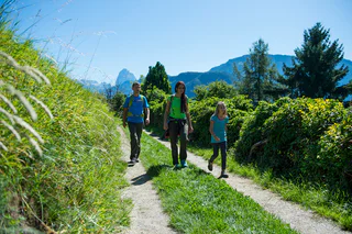
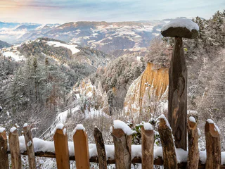
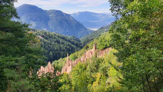
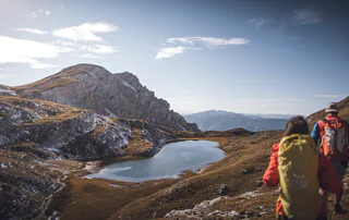
1/4
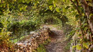
Post Trail
Albion/Albions, Lajen/Laion
easy
Difficulty
500 m
Elevation gain
3h:36 min
duration
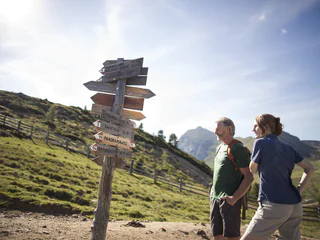
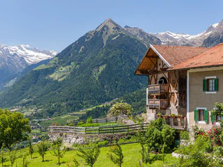
Panoramic trails offering views of stunning mountain scenery, leisurely family walks, or themed trails along historic irrigation channels. Whether you’re planning a holiday by train or a relaxing break in the dolomites without a car, South Tyrol offers plenty of walking routes that are easily accessible by bus and train. Climb aboard, enjoy your walking tour, and afterwards catch public transport back again. Shorter stages are also easy to plan. You can also easily reach popular starting points such as the Dolomite passes by public transport. This way, you can stay flexible on the go and experience the mountains more fully.
1/4
Albion/Albions, Lajen/Laion
easy
Difficulty
500 m
Elevation gain
3h:36 min
duration
1/7
Stanghe/Stange, Ratschings/Racines, Sterzing/Vipiteno and environs
easy
Difficulty
287 m
Elevation gain
1h:03 min
duration
1/5
Siusi/Seis, Kastelruth/Castelrotto, Dolomites Region Seiser Alm
easy
Difficulty
280 m
Elevation gain
2h:00 min
duration
1/5
Casere/Kasern, Prettau/Predoi, Ahrntal/Valle Aurina
easy
Difficulty
365 m
Elevation gain
1h:45 min
duration
1/7
Collepietra/Steinegg, Karneid/Cornedo all'Isarco, Dolomites Region Eggental
medium
Difficulty
355 m
Elevation gain
1h:52 min
duration
1/4
Ridanna/Ridnaun, Ratschings/Racines, Sterzing/Vipiteno and environs
medium
Difficulty
1450 m
Elevation gain
8h:00 min
duration
1/3
Taisten/Tesido, Welsberg-Taisten/Monguelfo-Tesido
medium
Difficulty
637 m
Elevation gain
3h:23 min
duration
1/2
Fleres/Pflersch, Brenner/Brennero, Sterzing/Vipiteno and environs
easy
Difficulty
433 m
Elevation gain
3h:40 min
duration

Telves/Telfes, Sterzing/Vipiteno, Sterzing/Vipiteno and environs
medium
Difficulty
638 m
Elevation gain
6h:00 min
duration
Castelrotto/Kastelruth, Kastelruth/Castelrotto, Dolomites Region Seiser Alm
easy
Difficulty
528 m
Elevation gain
3h:28 min
duration
1/2
Klobenstein/Collalbo, Ritten/Renon, Bolzano/Bozen and environs
medium
Difficulty
676 m
Elevation gain
3h:46 min
duration
1/3
Leifers/Laives, Laives/Leifers, Bolzano/Bozen and environs
medium
Difficulty
643 m
Elevation gain
2h:31 min
duration
1/5
Luson/Lüsen, Lüsen/Luson, Dolomites Region Lüsen Villnöss
medium
Difficulty
460 m
Elevation gain
2h:37 min
duration
1/6
Ceves/Tschöfs, Freienfeld/Campo di Trens, Sterzing/Vipiteno and environs
medium
Difficulty
285 m
Elevation gain
2h:30 min
duration
Kaltern Dorf/Caldaro Paese, Kaltern an der Weinstraße/Caldaro sulla Strada del Vino, Alto Adige Wine Road
medium
Difficulty
508 m
Elevation gain
4h:04 min
duration
1/3
Valdaora di Mezzo/Mitterolang, Olang/Valdaora, Dolomites Region Kronplatz/Plan de Corones
medium
Difficulty
1116 m
Elevation gain
4h:13 min
duration

1/3
Selva die Molini/Mühlwald, Mühlwald/Selva dei Molini, Ahrntal/Valle Aurina
medium
Difficulty
1021 m
Elevation gain
6h:00 min
duration
Casateia/Gasteig, Ratschings/Racines, Sterzing/Vipiteno and environs
easy
Difficulty
520 m
Elevation gain
2h:32 min
duration
1/4
Falzeben/Falzeben, Hafling/Avelengo, Meran/Merano and environs
medium
Difficulty
369 m
Elevation gain
2h:40 min
duration
1/6
Velloi/Vellau, Algund/Lagundo, Meran/Merano and environs
medium
Difficulty
612 m
Elevation gain
3h:07 min
duration
1/3
Percha/Perca, Dolomites Region Kronplatz/Plan de Corones
easy
Difficulty
620 m
Elevation gain
2h:15 min
duration
St. Walburg/Santa Valburga, Ulten/Ultimo, Meran/Merano and environs
medium
Difficulty
306 m
Elevation gain
2h:49 min
duration
1/3
Brixen Stadt/Bressanone città, Brixen/Bressanone, Brixen/Bressanone and environs
easy
Difficulty
346 m
Elevation gain
2h:31 min
duration
Karthaus/Certosa, Schnals/Senales, Vinschgau/Val Venosta
medium
Difficulty
532 m
Elevation gain
3h:25 min
duration
Transacqua/Ennewasser, Martell/Martello, Vinschgau/Val Venosta
difficult
Difficulty
1331 m
Elevation gain
5h:30 min
duration
Valgiovo/Jaufental, Ratschings/Racines, Sterzing/Vipiteno and environs
easy
Difficulty
336 m
Elevation gain
2h:34 min
duration
1/4
Monte Scena/Schennaberg, Schenna/Scena, Meran/Merano and environs
medium
Difficulty
450 m
Elevation gain
2h:30 min
duration
1/4
Plose/Plose, Brixen/Bressanone, Brixen/Bressanone and environs
difficult
Difficulty
1083 m
Elevation gain
4h:02 min
duration
Thank you for signing up!
You are already subscribed
Confirm your registration
To complete your subscription, open the email we just sent you and click on the confirmation link.
Can’t find it? Check your spam folder too.
We noticed that you are already subscribed to our Newsletter. We will update you on exclusive offers, fun adventures and more so you can make the best out of your vacation.
We noticed that you already tried to subscribe to our Newsletter in the past but didn’t confirmed the subscription. We have resent you an email now, please check your inbox and spam folder to confirm.


