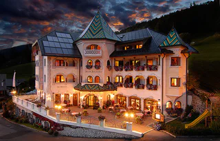
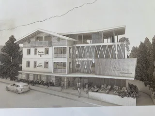
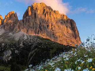
This phenomenon is more likely to happen on clear autumn days.
| Gröden vás okouzlí svou krásou a pohostinností. Objevte tradiční kulturu a vynikající lyžování. |
The Alpe di Seceda is located on the sunny side of Val Gardena, at the foot of the Parco Naturale Cisles-Odle (nature reserve), part of the Dolomites UNESCO World Heritage and represents an ideal base for hikes and climbing tours.
At the top station of the cable car you can enjoy a marvellous view of almost the entire South Tyrol as well as of the mountains in Trentino, Lombardy and Austria. Last but not least, you can admire the breathtaking peaks of the nearby Dolomites, of course: from the Tofane, the Sciliar and the Sella Massif to the Sassolungo and the "pearl" of the Dolomites, the "Marmolada".
From the Seceda summit you can enjoy a wonderful view of the Dolomites and of all the mountains in South Tyrol - from Ortles to Großglockner (Austria).
This path leads you from the top station of the Col Raiser cable way to the starting point of the Seceda Ridge Line trail.
The Ridge Line Trail hike, with its spectacular cliffside views, starts from the top station of the Seceda cable car and leads up to the summit cross at 2,519 m, continuing on to the Forcella Pana. There you will find a viewpoint with the surrounding peaks clearly marked.
The actual Ridge Line Trail is about 1 km long and can be comfortably completed in around one hour at a leisurely pace, including stops to enjoy the panorama.
Please note: descending east from the summit cross (trail no. 6) you will now find a turnstile (€ 5) that allows continued access to the trail up to the Forcella Pana. This section is not strictly necessary, as you will already have enjoyed stunning views from higher up.
To continue your hike into the Puez-Odle Nature Park or down to the Mastlé Alp located below, you can also take trail no. 1, which branches off further down.
This path leads you from the Cristauta parking lot/bus stop via Sëurasas and Pic Mountain to the starting point of the Seceda Ridge Line trail.
The Ridge Line Trail hike, with its spectacular cliffside views, starts from the top station of the Seceda cable car and leads up to the summit cross at 2,519 m, continuing on to the Forcella Pana. There you will find a viewpoint with the surrounding peaks clearly marked.
The actual Ridge Line Trail is about 1 km long and can be comfortably completed in around one hour at a leisurely pace, including stops to enjoy the panorama. We therefore recommend including it as part of a longer day hike. The Ridge Line Trail can be incorporated at the beginning, in the middle, or at the end of your tour.
Please note: descending east from the summit cross (trail no. 6) you will now find a turnstile (€ 5) that allows continued access to the trail up to the Forcella Pana. This section is not strictly necessary, as you will already have enjoyed stunning views from higher up.
To continue your hike into the Puez-Odle Nature Park or down to the Mastlé Alp located below, you can also take trail no. 1, which branches off further down.
This path leads you from the valley station of the Col Raiser cable way to the starting point of the Seceda Ridge Line trail.
The Ridge Line Trail hike, with its spectacular cliffside views, starts from the top station of the Seceda cable car and leads up to the summit cross at 2,519 m, continuing on to the Forcella Pana. There you will find a viewpoint with the surrounding peaks clearly marked.
The actual Ridge Line Trail is about 1 km long and can be comfortably completed in around one hour at a leisurely pace, including stops to enjoy the panorama.
Please note: descending east from the summit cross (trail no. 6) you will now find a turnstile (€ 5) that allows continued access to the trail up to the Forcella Pana. This section is not strictly necessary, as you will already have enjoyed stunning views from higher up.
To continue your hike into the Puez-Odle Nature Park or down to the Mastlé Alp located below, you can also take trail no. 1, which branches off further down.
Extra thrill, extra butterflies in your stomach and extra adventurous skiing fun at the Sella Ronda – that’s the brand-new Funslope Selva at the ski lifts “Risaccia” at Selva in Val Gardena. Prepare yourself for the new snow adventure: We race over the soundboost, carve through three steep turns, swirl through the fun twister, give the huge cushioned hand a high five while sliding over four waves and greet Slopy, the Funslope inhabitant, when we arrive on the finish line. This exciting and varied snow adventure is waiting for you in the season 2017/18 at the Sella Ronda in Selva!
The hike starts at the parish church of Ortisei and follows the “Via del Dialogo” towards San Giacomo, along a path immersed in the forest. The historic San Giacomo church already offers a first impressive viewpoint. The route then continues towards Balest, from where a splendid view opens up over Ortisei. Continuing towards Seurasas, the panorama becomes even wider, with spectacular views of the Dolomites. After a break at Baita Curona, the itinerary ends at the Seceda - Ridge Line, where the landscape offers breathtaking views of the surrounding mountains. A moderately difficult tour, ideal for nature lovers and those who enjoy panoramic hikes.
This path leads you from the valley station of the Col Raiser cable way, via Rifugio Firenze to the starting point of the Seceda Ridge Line trail.
The Ridge Line Trail hike, with its spectacular cliffside views, starts from the top station of the Seceda cable car and leads up to the summit cross at 2,519 m, continuing on to the Forcella Pana. There you will find a viewpoint with the surrounding peaks clearly marked.
The actual Ridge Line Trail is about 1 km long and can be comfortably completed in around one hour at a leisurely pace, including stops to enjoy the panorama.
Please note: descending east from the summit cross (trail no. 6) you will now find a turnstile (€ 5) that allows continued access to the trail up to the Forcella Pana. This section is not strictly necessary, as you will already have enjoyed stunning views from higher up.
To continue your hike into the Puez-Odle Nature Park or down to the Mastlé Alp located below, you can also take trail no. 1, which branches off further down.
The tour starts at the valley station of the Resciesa funicular in Ortisei. After taking the ride up, follow trail no. 35 over the Brogles Saddle to the Brogles Hut. The demanding ascent through the Forcella Mezdì is along trail no. 29. Arrived at the top, trail no. 2B leads past the Pieralongia Hut. The final stretch follows trail no. 6 along the spectacular Seceda Ridge Line.
This stage starts from Ortisei to the Brogles Alm, Focella Mesdì and the Mastlè Alp. After you reach the Forcella Forces de Sieles the trail runs on the Alta Via Dolomiti N° 2 until the Puez hut.http://www.sii.bz.it/
There is a large marmot population in the area at the foot of the Plattkofel. This is why this tour is often called "Marmot walk". With a bit of luck you might even come a cross one of those animals on this trail.
The hike begins in the charming hamlet of Daunëi, located above Selva di Val Gardena at an altitude of around 1,680 m. From the small hiking car park, follow the well-marked trail no. 3, which ascends gently through alpine meadows and sparse larch forests. After about 30 minutes, you reach the picturesque Juac Hut (1,905 m).
From the Juac Hut, continue uphill along trail no. 3 toward the Regensburger Hütte (Rifugio Firenze). The path winds through high alpine meadows and light woodland, accompanied by increasingly spectacular views of the Val Gardena. After a total of approximately 1.5 to 2 hours, you arrive at the hut, beautifully situated at the foot of the dramatic Odle peaks.
Above the Regensburger Hütte, the hike continues toward the so-called UNESCO Terrace – a spectacular viewpoint offering unobstructed views of the Odle Group and the surrounding Dolomite peaks. Here, follow trail no. 2, which climbs moderately from the hut to the panoramic platform. The UNESCO Terrace is officially part of the Dolomites World Heritage and is ideal for a well-earned scenic pause.
Those with enough energy and time can continue the ascent to the famous Seceda viewpoint (approx. 2,500 m). The route consists of a combination of marked trails – typically no. 13, followed by 2B, and finally trail no. 6, leading to the highest point of the Seceda plateau. This viewpoint is one of the most iconic photo spots in the Dolomites, with its sharp Odle peaks and the wide view over Val Gardena.
The return follows the same route: from the Seceda viewpoint back to the UNESCO Terrace, then down to the Regensburger Hütte, continuing on trail no. 3 to the Juac Hut and finally descending to Daunëi.
The Vallunga is the entrance to the Naturepark Puez - Odle. It lasts a few km and it's in the middle of woods and mountains. The valley has a flair of quiteness and calm and everybody can enjoy it during a walk in the valley.
This path leads you from the Cristauta parking lot/bus stop via Sëurasas to the starting point of the Seceda Ridge Line trail.
The Ridge Line Trail hike, with its spectacular cliffside views, starts from the top station of the Seceda cable car and leads up to the summit cross at 2,519 m, continuing on to the Forcella Pana. There you will find a viewpoint with the surrounding peaks clearly marked.
The actual Ridge Line Trail is about 1 km long and can be comfortably completed in around one hour at a leisurely pace, including stops to enjoy the panorama. We therefore recommend including it as part of a longer day hike. The Ridge Line Trail can be incorporated at the beginning, in the middle, or at the end of your tour.
Please note: descending east from the summit cross (trail no. 6) you will now find a turnstile (€ 5) that allows continued access to the trail up to the Forcella Pana. This section is not strictly necessary, as you will already have enjoyed stunning views from higher up.
To continue your hike into the Puez-Odle Nature Park or down to the Mastlé Alp located below, you can also take trail no. 1, which branches off further down.
Whether in summer when hiking or on the bike or in winter on skis, Dantercepies and the area around the Sellaronda offer beautiful hikes, exciting flow trails and perfectly prepared ski slopes.
Bike Park & Flow trails in Selva di Val Gardena - South Tyrol
New and unspoiled trails, the Dantercepies cable car within easy reach and the amazing landscape of the Dolomites as far as the eye can see - an ideal mountain bike destination
2 flow trails that will make any biker’s day! Both trails consist of a 1.6 km easy line, making it a blast for children and adults alike. Thanks to the Dantercepies lift facility and the Cir chairlift, both trails can be easily reached as many times as you like. Nothing will get in the way of your fun day out! ENJOY THE FLOW RIDE!
This path leads you from the Cristauta parking lot/bus stop to the starting point of the Seceda Ridge Line trail.
The Ridge Line Trail hike, with its spectacular cliffside views, starts from the top station of the Seceda cable car and leads up to the summit cross at 2,519 m, continuing on to the Forcella Pana. There you will find a viewpoint with the surrounding peaks clearly marked.
The actual Ridge Line Trail is about 1 km long and can be comfortably completed in around one hour at a leisurely pace, including stops to enjoy the panorama. We therefore recommend including it as part of a longer day hike. The Ridge Line Trail can be incorporated at the beginning, in the middle, or at the end of your tour.
Please note: descending east from the summit cross (trail no. 6) you will now find a turnstile (€ 5) that allows continued access to the trail up to the Forcella Pana. This section is not strictly necessary, as you will already have enjoyed stunning views from higher up.
To continue your hike into the Puez-Odle Nature Park or down to the Mastlé Alp located below, you can also take trail no. 1, which branches off further down.
Whether in summer when hiking or on the bike or in winter on skis, Dantercepies and the area around the Sellaronda offer beautiful hikes, exciting flow trails and perfectly prepared ski slopes.
Bike Park & Flow trails in Selva di Val Gardena - South Tyrol
New and unspoiled trails, the Dantercepies cable car within easy reach and the amazing landscape of the Dolomites as far as the eye can see - an ideal mountain bike destination
2 flow trails that will make any biker’s day! Both trails consist of a 1.6 km easy line, making it a blast for children and adults alike. Thanks to the Dantercepies lift facility and the Cir chairlift, both trails can be easily reached as many times as you like. Nothing will get in the way of your fun day out! ENJOY THE FLOW RIDE!
At the entrance to the Puez-Geisler Nature Park, a place of profound silence stretches for several kilometres. Embedded in the valley between dense forests and majestic mountains, hikers immerse themselves here in an oasis of tranquility. With every step, one feels the primeval power and peaceful atmosphere emanating deeply from the woodland.
The “Dolomites Saslong Half Marathon” is the new edition of the popular "Val Gardena Mountain Run” and is one of the most scenic mountain runs in the world taking place right here in the heart of the Dolomites.
The 21,1 km trail run (with 900 metres of altitude difference) starts and ends in the beautiful area of Monte Pana and takes the runners along a partial rock and boulder route around the Sassolungo Group. Fantastic views are to be had over the Sella Group, Marmolada, Alpe di Siusi and Sciliar.
This classic hike runs across the steep Forcella Piza to Alpe Stevia, where you can catch a unique view to the Cir peaks.
The Sasso Piatto il situated between Val Gardena and the Altopiano dello Sciliar in proximity of the Sassolungo.