
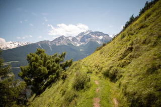
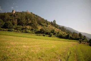
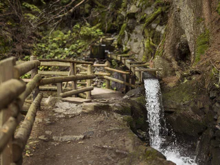
"Latschanderwaal" irrigation channel path
Laces/Latsch, Kastelbell-Tschars/Castelbello-Ciardes, Vinschgau/Val Venosta
easy
Difficulty
65 m
Elevation gain
1h:30 min
duration
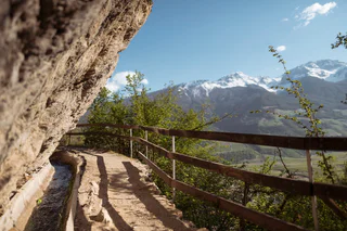
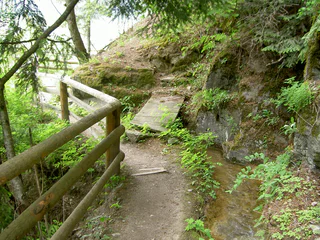
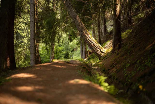
Due to scarce rainfall, farmers in Vinschgau had to come up with creative ideas. That’s why they built the so-called "Waale", irrigation canals that transported water to pastures and fields. Today, the fascinating narrow trails that meander through forests, orchards, past castles, forts and chapels, are popular hiking destinations – surprisingly, the irrigation canals on the Malser Haide in the Obervinschgau valley have also been declared a UNESCO World Heritage Site. Above all in spring and autumn, you should walk through this Mediterranean-like landscape and listen to the healing sound of water.
Laces/Latsch, Kastelbell-Tschars/Castelbello-Ciardes, Vinschgau/Val Venosta
easy
Difficulty
65 m
Elevation gain
1h:30 min
duration
Laces/Latsch, Latsch/Laces, Vinschgau/Val Venosta
easy
Difficulty
50 m
Elevation gain
2h:00 min
duration
Tarres/Tarsch, Latsch/Laces, Vinschgau/Val Venosta
medium
Difficulty
493 m
Elevation gain
3h:32 min
duration
Morter/Morter, Latsch/Laces, Vinschgau/Val Venosta
easy
Difficulty
292 m
Elevation gain
2h:47 min
duration
Transacqua/Ennewasser, Martell/Martello, Vinschgau/Val Venosta
easy
Difficulty
239 m
Elevation gain
1h:30 min
duration
Glorenza/Glurns, Glurns/Glorenza, Vinschgau/Val Venosta
medium
Difficulty
650 m
Elevation gain
4h:30 min
duration
Morter/Morter, Latsch/Laces, Vinschgau/Val Venosta
easy
Difficulty
210 m
Elevation gain
3h:15 min
duration
1/4
Malles/Mals, Mals/Malles, Vinschgau/Val Venosta
medium
Difficulty
392 m
Elevation gain
5h:00 min
duration
Prato /Prad, Prad am Stilfser Joch/Prato allo Stelvio, Vinschgau/Val Venosta
medium
Difficulty
373 m
Elevation gain
2h:00 min
duration
Montechiaro/Lichtenberg, Prad am Stilfser Joch/Prato allo Stelvio, Vinschgau/Val Venosta
easy
Difficulty
234 m
Elevation gain
2h:30 min
duration
1/6
Monte di Tramontana/Nördersberg, Schlanders/Silandro, Vinschgau/Val Venosta
easy
Difficulty
150 m
Elevation gain
1h:03 min
duration
Juvale/Juval, Kastelbell-Tschars/Castelbello-Ciardes, Vinschgau/Val Venosta
easy
Difficulty
300 m
Elevation gain
3h:00 min
duration
1/2
Glorenza/Glurns, Glurns/Glorenza, Vinschgau/Val Venosta
medium
Difficulty
502 m
Elevation gain
3h:04 min
duration
Laces/Latsch, Latsch/Laces, Vinschgau/Val Venosta
easy
Difficulty
177 m
Elevation gain
1h:26 min
duration
1/3
Sluderno/Schluderns, Schluderns/Sluderno, Vinschgau/Val Venosta
medium
Difficulty
500 m
Elevation gain
4h:00 min
duration
1/4
Monte di Tramontana/Nördersberg, Schlanders/Silandro, Vinschgau/Val Venosta
medium
Difficulty
370 m
Elevation gain
4h:10 min
duration
1/3
Monte di Tramontana/Nördersberg, Schlanders/Silandro, Vinschgau/Val Venosta
easy
Difficulty
70 m
Elevation gain
0h:31 min
duration
1/3
Juvale/Juval, Kastelbell-Tschars/Castelbello-Ciardes, Vinschgau/Val Venosta
medium
Difficulty
258 m
Elevation gain
2h:40 min
duration
Morter/Morter, Latsch/Laces, Vinschgau/Val Venosta
easy
Difficulty
122 m
Elevation gain
1h:22 min
duration
1/2
Silandro/Schlanders, Schlanders/Silandro, Vinschgau/Val Venosta
medium
Difficulty
300 m
Elevation gain
1h:06 min
duration
1/3
Tubre/Taufers i. M., Taufers im Münstertal/Tubre, Vinschgau/Val Venosta
medium
Difficulty
290 m
Elevation gain
2h:10 min
duration
Tablà/Tabland - Naturno/Naturns, Naturns/Naturno, Vinschgau/Val Venosta
easy
Difficulty
160 m
Elevation gain
2h:00 min
duration
1/2
Sluderno/Schluderns, Schluderns/Sluderno, Vinschgau/Val Venosta
easy
Difficulty
290 m
Elevation gain
3h:00 min
duration
Laces/Latsch, Latsch/Laces, Vinschgau/Val Venosta
easy
Difficulty
0 m
Elevation gain
0h:54 min
duration
Ganda/Gand - Martello/Martell, Martell/Martello, Vinschgau/Val Venosta
easy
Difficulty
215 m
Elevation gain
1h:15 min
duration
1/3
Covelano/Göflan, Schlanders/Silandro, Vinschgau/Val Venosta
medium
Difficulty
462 m
Elevation gain
2h:55 min
duration
1/3
Montechiaro/Lichtenberg, Prad am Stilfser Joch/Prato allo Stelvio, Vinschgau/Val Venosta
medium
Difficulty
369 m
Elevation gain
2h:00 min
duration
1/2
Juvale/Juval, Kastelbell-Tschars/Castelbello-Ciardes, Vinschgau/Val Venosta
medium
Difficulty
219 m
Elevation gain
2h:00 min
duration
Thank you for signing up!
You are already subscribed
Confirm your registration
To complete your subscription, open the email we just sent you and click on the confirmation link.
Can’t find it? Check your spam folder too.
We noticed that you are already subscribed to our Newsletter. We will update you on exclusive offers, fun adventures and more so you can make the best out of your vacation.
We noticed that you already tried to subscribe to our Newsletter in the past but didn’t confirmed the subscription. We have resent you an email now, please check your inbox and spam folder to confirm.


