
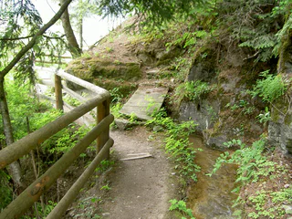
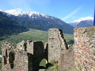
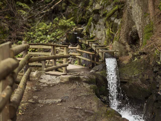
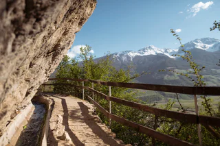
Neuwaal irrigation channel path
Laces/Latsch, Latsch/Laces, Vinschgau/Val Venosta
easy
Moeilijkheidsgraad
177 m
Hoogteverschil
1h:26 min
Duur
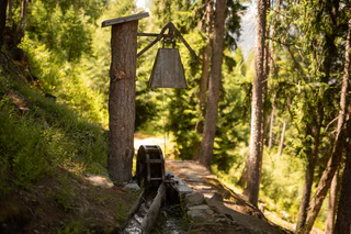
Weinig regen maakte de boeren in de Vinschgau al eeuwen geleden vindingrijk. Zo legden ze de zogenaamde "Waale" aan: irrigatiekanalen die de weiden en akkers van het kostbare water voorzagen. Tegenwoordig zijn de smalle paden, die door bossen en boomgaarden slingeren en langs burchten, kastelen en kapellen lopen, geliefde wandelroutes – de Waale op de Malser Haide in de Obervinschgau zijn zelfs uitgeroepen tot UNESCO-werelderfgoed. Vooral in de lente en de herfst is het de moeite waard om het zachte gekabbel door het mediterrane landschap te volgen.
Laces/Latsch, Latsch/Laces, Vinschgau/Val Venosta
easy
Moeilijkheidsgraad
177 m
Hoogteverschil
1h:26 min
Duur
1/2
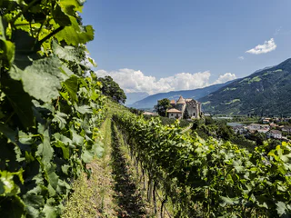
Glorenza/Glurns, Glurns/Glorenza, Vinschgau/Val Venosta
medium
Moeilijkheidsgraad
502 m
Hoogteverschil
3h:04 min
Duur
1/4
Monte di Tramontana/Nördersberg, Schlanders/Silandro, Vinschgau/Val Venosta
medium
Moeilijkheidsgraad
370 m
Hoogteverschil
4h:10 min
Duur
1/2
Silandro/Schlanders, Schlanders/Silandro, Vinschgau/Val Venosta
medium
Moeilijkheidsgraad
300 m
Hoogteverschil
1h:06 min
Duur
1/3
Sluderno/Schluderns, Schluderns/Sluderno, Vinschgau/Val Venosta
medium
Moeilijkheidsgraad
500 m
Hoogteverschil
4h:00 min
Duur
Laces/Latsch, Kastelbell-Tschars/Castelbello-Ciardes, Vinschgau/Val Venosta
easy
Moeilijkheidsgraad
65 m
Hoogteverschil
1h:30 min
Duur
1/2
Juvale/Juval, Kastelbell-Tschars/Castelbello-Ciardes, Vinschgau/Val Venosta
medium
Moeilijkheidsgraad
219 m
Hoogteverschil
2h:00 min
Duur
Tarres/Tarsch, Latsch/Laces, Vinschgau/Val Venosta
medium
Moeilijkheidsgraad
493 m
Hoogteverschil
3h:32 min
Duur
Tubre/Taufers i. M., Taufers im Münstertal/Tubre, Vinschgau/Val Venosta
medium
Moeilijkheidsgraad
290 m
Hoogteverschil
2h:10 min
Duur
1/3
Montechiaro/Lichtenberg, Prad am Stilfser Joch/Prato allo Stelvio, Vinschgau/Val Venosta
medium
Moeilijkheidsgraad
369 m
Hoogteverschil
2h:00 min
Duur
1/3
Juvale/Juval, Kastelbell-Tschars/Castelbello-Ciardes, Vinschgau/Val Venosta
medium
Moeilijkheidsgraad
258 m
Hoogteverschil
2h:40 min
Duur
Prato /Prad, Prad am Stilfser Joch/Prato allo Stelvio, Vinschgau/Val Venosta
medium
Moeilijkheidsgraad
373 m
Hoogteverschil
2h:00 min
Duur
Transacqua/Ennewasser, Martell/Martello, Vinschgau/Val Venosta
easy
Moeilijkheidsgraad
239 m
Hoogteverschil
1h:30 min
Duur
1/2
Sluderno/Schluderns, Schluderns/Sluderno, Vinschgau/Val Venosta
easy
Moeilijkheidsgraad
290 m
Hoogteverschil
3h:00 min
Duur
Montechiaro/Lichtenberg, Prad am Stilfser Joch/Prato allo Stelvio, Vinschgau/Val Venosta
easy
Moeilijkheidsgraad
234 m
Hoogteverschil
2h:30 min
Duur
Morter/Morter, Latsch/Laces, Vinschgau/Val Venosta
easy
Moeilijkheidsgraad
292 m
Hoogteverschil
2h:47 min
Duur
1/6
Monte di Tramontana/Nördersberg, Schlanders/Silandro, Vinschgau/Val Venosta
easy
Moeilijkheidsgraad
150 m
Hoogteverschil
1h:03 min
Duur
Laces/Latsch, Latsch/Laces, Vinschgau/Val Venosta
easy
Moeilijkheidsgraad
0 m
Hoogteverschil
0h:54 min
Duur
1/3
Covelano/Göflan, Schlanders/Silandro, Vinschgau/Val Venosta
medium
Moeilijkheidsgraad
462 m
Hoogteverschil
2h:55 min
Duur
Tablà/Tabland - Naturno/Naturns, Naturns/Naturno, Vinschgau/Val Venosta
easy
Moeilijkheidsgraad
160 m
Hoogteverschil
2h:00 min
Duur
Glorenza/Glurns, Glurns/Glorenza, Vinschgau/Val Venosta
medium
Moeilijkheidsgraad
650 m
Hoogteverschil
4h:30 min
Duur
Laces/Latsch, Latsch/Laces, Vinschgau/Val Venosta
easy
Moeilijkheidsgraad
50 m
Hoogteverschil
2h:00 min
Duur
1/4
Malles/Mals, Mals/Malles, Vinschgau/Val Venosta
medium
Moeilijkheidsgraad
392 m
Hoogteverschil
7h:00 min
Duur
Ganda/Gand - Martello/Martell, Martell/Martello, Vinschgau/Val Venosta
easy
Moeilijkheidsgraad
215 m
Hoogteverschil
1h:15 min
Duur
Morter/Morter, Latsch/Laces, Vinschgau/Val Venosta
easy
Moeilijkheidsgraad
122 m
Hoogteverschil
1h:22 min
Duur
Morter/Morter, Latsch/Laces, Vinschgau/Val Venosta
easy
Moeilijkheidsgraad
210 m
Hoogteverschil
3h:15 min
Duur
Juvale/Juval, Kastelbell-Tschars/Castelbello-Ciardes, Vinschgau/Val Venosta
easy
Moeilijkheidsgraad
300 m
Hoogteverschil
3h:00 min
Duur
1/3
Monte di Tramontana/Nördersberg, Schlanders/Silandro, Vinschgau/Val Venosta
easy
Moeilijkheidsgraad
70 m
Hoogteverschil
0h:31 min
Duur
Bedankt voor je inschrijving!
Inschrijving al actief
Bevestig je inschrijving
Om je inschrijving te voltooien, open de e-mail die we je net hebben gestuurd en klik op de bevestigingslink.
Niet gevonden? Kijk ook even in je spammap.
Je ontvangt al onze exclusieve aanbiedingen, handige tips en speciale suggesties om volop van je vakantie te genieten.
Je hebt je al geprobeerd in te schrijven voor onze nieuwsbrief maar deze nog niet bevestigd. We hebben je de e‑mail zojuist opnieuw gestuurd. Controleer je inbox en je spammap en bevestig nu.


