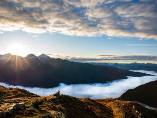
Skip to content

added to favourites

removed from favourites

Oops! Something went wrong. Try again

Your account is being created

Your account has been successfully created and you are now logged in

You’ve been logged in successfully!

Your account was created successfully, but we couldn't log you in automatically

You are logged out.

Filter
Selected filters
    Level of difficulty
    Duration
    Distance in KM

    Hiking trails in Ahrntal/Valle Aurina

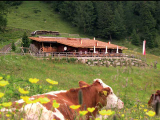
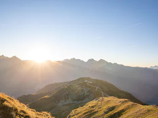
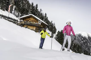
    Walking is the best way to enjoy wonderful stretches of greenery. During your spring in South Tyrol, you can witness the awakening of nature in the valley and on the alpine meadows in bloom. Midsummer days are equally surprising:  people are lured to mountain peaks, marvel at sweeping views and indulge in the traditional dishes served in quaint mountain huts. Go on a hike to watch the spectacle of autumn’s glorious colours and relax in nature.

    Results
    Summer
    Legend Path
    Sand in Taufers/Campo Tures, Ahrntal/Valle Aurina

    The Tauferer Ahrntal (valley) is rich in legends. Some of these are presented on the Tauferer Valley Legend Trail. Children are drawn into an exciting world of magic, adults learn something about the mystics of Taufers. The legends are told on display boards. We hear about the little woman from Oberpurstein, about the Antrischen people, about the castle on Purstein, the treasure at Tobl and the doom of the Walburg Castle.


    Difficulty: medium
    193 m elevation gain
    2h:30 min duration
    Summer
    St. Francis' Path at the Reinbach Waterfalls
    Sand in Taufers/Campo Tures, Ahrntal/Valle Aurina

    10 meditational spots are found along the side of the path until we reach the "Franziskus and Klara" chapel. By entering the symbolic gate near the car park you enter a new world. Furthermore, those who hike this path in silence will have a rich experience. The chapel is open day and night. The Liturgy of the Word (religious readings) can be celebrated by groups without asking beforehand. Any plan to celebrate the Eucharist (communion) should be reported to the "service for youth organisation", tel. + 39 0474 678119 or the priest´s office Taufers, tel. +39 0474 678060

    Difficulty: medium
    323 m elevation gain
    2h:40 min duration
    Long-Distance Hiking Paths
    Hoch Tirol Trail
    Prettau/Predoi, Ahrntal/Valle Aurina
    The Hoch-Tirol long-distance trail consists of three stages. It joins Prettau/Predoi, located at the end of the Ahrntal valley, with Prägraten am Großvendiger in Eastern Tirol. The South Tyrolean part of the trail crosses the Rieserferner-Ahrn Nature Park, while the East Tirolean stretch crosses the Hohe Tauern National Park. The 27,9-km trail boasts 1490 hm ascent and 1000 hm descent in South Tyrol.  
    Difficulty: difficult
    1659 m elevation gain
    9h:09 min duration
    Summer
    Knight's trail
    Sand in Taufers/Campo Tures, Ahrntal/Valle Aurina
    From the Tourist Office in Sand in Taufers/Campo Tures, walk in a easterly direction and cross the bridge to St. Moritzen/San Maurizio. Turn right and walk along the left banks of the river, cross another bridge to the right bank. Then take another bridge on the left and turn right towards Winkel. On the left side you can find the Kneipp trail. Walk along the road to the car park for the Reinbach Waterfalls. Turn left into the forest (nr. 2) until you come to the first Reinbach waterfall. The road leads upwards to the 2nd and the 3rd waterfall. Cross the high bridge at the 3rd waterfall and turn onto path number 2 towards the Toblhof restaurant. Cross the road and follow path number 2A, which leads you slightly descending to the Pircherhöfe. Then turnleft throught the forest until you come to a crossroads. Turn right and walk to Taufers Castle and enjoy the panoramic views. Walk along a small path, passing the castle chapel until you are bacj in Sand in Taufers/Campo Tures. Cross the bridge at the main road and walk towards the end of the village.
    Difficulty: medium
    344 m elevation gain
    2h:28 min duration
    Summer
    Miner's Path Prettau/Predoi
    Prettau/Predoi, Ahrntal/Valle Aurina

    In the footsteps of miners: An educational trail starting from the St. Ignaz mining gallery (1,500 m) to Rötkreuz/Croce della Val Rossa (2,080 m) that passes entrances to mine and the dilapidated remnants of former mining works.

    The Saint George tunnel (adit), which turns towards the right from the road and leads you directly into the mountain was built soon after 1528. Although it is no more than 100 metres long, ore was only found at the beginning of the 40’s, as at times, there was only one miner working in this tunnel. Near the ‘Jakober Stuben’, which are the remains of former mine buildings near the entrance (‘Mundloch’) to the Saint Jacob’s tunnel, the upper part of the mine begins. This is the part, where ore was found during the 15th Century. It is said that Prettau copper ore was first found during the Bronze Age. If this is true, it was most likely found here in this mine. At some stage, there were several tunnels leading into the mountain, but only a few of them can be seen today. The most upper tunnel was called Saint Wilhelm. This was the ‘treasure chest’ of the mine, i.e. copper ore was first found here. The wild and romantic landscape between the ‘Jakober Stuben’ and the Saint Wilhelm tunnel did not grow naturally, but was created by man. This happened during the 18th Century, when the ore was partly mined with the help of black powder. The educational trail ends at the Rötkreuz/Croce della Val Rossa (2,080 m).

    Difficulty: medium
    556 m elevation gain
    1h:55 min duration
    Summer
    Ahrntal Sun Trail - Witch's Trail
    Ahrntal/Valle Aurina, Ahrntal/Valle Aurina

    Children need constant change and are always looking for adventure. The Ahrntaler Sonnenwege (sunny trails) and especially its Ahrntaler Hexensteig (Witch’s trail) is the ideal spot to give families such exciting adventures. It starts at Mühlegg/Costa Molini from where you walk to the rushing Frankbachwasserfall (waterfalls). Continue on and pass an old millstone which tells us a little about the farm life of long ago. You then get to some rocks which are ideal for children looking for adventure and who want to test their climbing skills. The very brave children may even dare to enter into the bear cave and walk through the 20 m long underground tunnel where they will have to pass the witch’s big chair and a wooden carved family of bears before reaching the end of their hiking destination – the family friendly Bizathütte (lodge) which welcomes you with its mountain restaurant.

    Difficulty: medium
    400 m elevation gain
    1h:45 min duration
    Summer
    Daimerweg [trail] – Sand in Taufers
    Sand in Taufers/Campo Tures, Ahrntal/Valle Aurina

    The Speikboden is more than just a favorite ski area. It is also an ideal hiking area. The mountain got its name from a little flower that grows in the high mountains – Alpine valerian, or “Speik” in German – and that is in fact because this lovely flower is often found in the hiking area.

    With the cable cars you can reach the "Speikboden Alm" at 2000 metres of altitude or the Sonnklar mountain at 2400 metres above sea level. Both are starting points for fantastic walks and hikes along well maintained trails. Particularly popular are the sunrise walks - to spot the first sunrays while the valley still lies in darkness is a memorable experience.

    Difficulty: easy
    12 m elevation gain
    1h:55 min duration
    Summer
    Breite Rast: 2098m
    Ahrntal/Valle Aurina, Ahrntal/Valle Aurina

    Ideal continuation from lake Klaussee to return to the mountian station. Trail no. 33b hike time: 1hrs modest elevation gain from Lake Klaussee. The trail starts from the lake, passes through moraine hills, by an old cattle shed and reaches the "Breite Rast", where there is a fantastic view of the Zillertal Alps. From there, one can either descend to the upper cableway station or continue crossing the "Großklausental" and "Ploden", to St. Jacob or Steinhaus.

    Difficulty: medium
    94 m elevation gain
    1h:00 min duration
    Summer
    Ahrntal Sun Trails - Leonardi Trail
    Ahrntal/Valle Aurina, Ahrntal/Valle Aurina

    The trail leads you to a truly unique sight: the artist Jakob Oberhollenzer’s exposition park that includes a series of breathtaking life-size wooden sculptures. You’ll quickly realize however that this is a trail every bit as much about the journey as the destination. You will see stunning scenery, views of life in this valley from long ago to now, farm work, art and reflections of times past. The trail starts in St. Jakob and goes along the sunny path above the village through fields, forests and after a short distance along the old “Mühlweg” it brings you back to where you started. At various spots hikers get a look into rural-life and farm work through texts and images. The focus is on the themes: “From grain to bread”, “From flax to linen” and “Woodwork in the forest” in the course of the various seasons. In addition, there is the possibility to experience going bare-foot and treading in the refreshing glacier water. The trail is named after the patron saint Leonhard,the advocate for farmers and their diverse interests. Religion and popular beliefs have left a lasting impression on rural-life here. You can walk back from the Sculpture Garden along the street directly to the village. Or the longer route takes you past some of the local farms, past the bus stop in front of Gasthof Garber and then back to the car park.

    Difficulty: easy
    245 m elevation gain
    1h:13 min duration
    Summer
    Sun Path Ahrntal valley - Sunnsat
    Prettau/Predoi, Ahrntal/Valle Aurina

    The sun trail "Sunnsat" is a net of ways and invites to walk and to peregrinate. These ways in the times gone by, were used by smugglers and for other things. Now doing this ways you can pass the blooming fields, the mixed forest, the traditional farms und the huts.

    DOWNLOAD AHRNTAL SUN TRAIL - MAP

    Difficulty: medium
    1156 m elevation gain
    6h:22 min duration
    Summer
    Alpine vegetation
    Sand in Taufers/Campo Tures, Ahrntal/Valle Aurina

    Ascending the mountain, the hike leads you to the so-called Schlafhäuser (sleeping houses), which the farmers used as shelters and for cooking when the hay was harvested. The route continues high above the Reintal valley, crossing the southern slope of the Mosstock peak. Dwarf shrub heathland, marvellous pines and characteristic highland moors can be found along the way. Blooming alpine flowers invite you to take a rest and to marvel at the stunning views, reaching from the close glaciers of the Rieserferner mountain range to the Dolomites in the distance.


    Difficulty: medium
    700 m elevation gain
    2h:30 min duration
    Summer
    Jochkofel: 2653m
    Ahrntal/Valle Aurina, Ahrntal/Valle Aurina

    Beautiful hike to the summit of the Klausberg. Offers an enchanting panoramic view of the Dolomites, Zillertal Alps, Durreck and Rieserferner Group. Trail no. 33 hike time: 3 to 3.5 hrs elevation gain: 1050 m From the Klausberg upper station to Lake Klaussee. From there, the trail continues to the pass and then, in about 20 minutes it reaches the summit (the section from the pass to the summit involves some light bouldering). You can descend by the same trail. Tip: from "Jochkofel", passing Obersteiner Alm, down to Luttach or through the Pojental to Sand in Taufers (fantastic hike requiring an additional three to four hours).

    Difficulty: difficult
    1050 m elevation gain
    3h:30 min duration
    Summer
    Art of living
    Ahrntal/Valle Aurina, Ahrntal/Valle Aurina

    The goal of the hike are the “Koflerseen“ lakes. You pass through varied parts of the forest and mountain pastures. Over centuries people have shaped the landscape and cultivated the land which is still well maintained. The lakes themselves are embedded in a mountainous region bounded by the boulders and debris left by the retreat of an old glacier. Around the banks of the lakes there are meadows covered by a vast variety of flowers spreading in all directions. These flowers show the art of survival in the high mountains. Last, but not least, the hike offers views of the glacial peaks of the Rieserferner Mountains.

    Difficulty: medium
    800 m elevation gain
    2h:30 min duration
    Summer
    Ahrntal Sun Trails - Mountain huts round trip
    Ahrntal/Valle Aurina, Ahrntal/Valle Aurina

    The Ahrntal Sun trail takes you to several traditional mountain lodges where you can stop to eat and through magnificent flower fields on the sunny side of the Zillertal Alps. You will get to see breathtaking views of the Ahrntal (valley), of the Dolomites and of the Rieserferner mountain group. Particularly impressive are the pastures and the beautiful flowers on the mountain meadows in almost alpine terrain. Up here the farmer produces food in accordance with nature and he gives the land back what he takes from it. You will get an insight into the difficult life as it once was up in these meadows and can compare it to the much less difficult life up there today. If you get hungry, you can always try the typical specialties from the area.

    Difficulty: medium
    2483 m elevation gain
    10h:09 min duration
    Summer
    High Altitude Path Prettau/Predoi
    Prettau/Predoi, Ahrntal/Valle Aurina

    Passing by "Knappenegg" and "Bruggerpichl" we reach the "St. Nikolaus-Herrenbaustollen" (adit) Historical Copper Mine. Here there is much to learn about mining and its influence on the developent of the valley. Continuing to "Innerbichlalm" you ascend 300 m through high alpine forests until at the "Pichlwiesn" (meadow) the mountainous panorama of the inner Ahrntal valley reveals itself to you. The unique flora is continuously noticeable until the Stegeralm hut, which gives an opportunity for a break in the midst of the stunning mountain scenery of the Durreck Group and Zillertaler Alps. If the group is still in good shape you can aim to the cross the "Alprechtgraben" gully to reach the cabin with the same name and th Felams look-out. The descent continues on he "Alprechter Almweg" path to the "Alprecht-Stöckl" chapel, and then on the bus stop at the "Stegerbrücke" bridge.

    Difficulty: medium
    373 m elevation gain
    4h:00 min duration
    Summer
    Nature Adventure Trail
    Sand in Taufers/Campo Tures, Ahrntal/Valle Aurina

    Bringing people close to nature...this is the aim of the nature experience path in Sand in Taufers. The circular path is about 3 to 4 miles long and was partially financed by the village of Sand in Taufers and the Department for Natural Parks.Its logo is a squirrel, which accompanies the hiker from one station to the next. Many themes are touched upon: nature, fauna, flora, geology, mythology, legends, myths….. Interesting ideas such as a look-out platform make this round-trip trail even more attractive. The Adventure Path for a Healthy Community will be built or accordingly expanded as part of a theme trails’ project in the autumn of 2015.


    Difficulty: medium
    201 m elevation gain
    3h:00 min duration
    Summer
    Klaussee: 2162 m
    Ahrntal/Valle Aurina, Ahrntal/Valle Aurina

    A very rewarding, medium difficulty hike to the most beautiful alpine lake in the Durreck group. Trail no. 33, 1,5 to 2 hrs elevation gain: 560 m The trail starts from the Klausberg upper station, passes the Speck & Schnapsalm, and reaches the Baurschaft refuge and lake Klaussee. From there, you can continue up to the Rauchkofel or Breite Rast.

    Difficulty: medium
    608 m elevation gain
    1h:23 min duration
    Summer
    Biocoenosis - high alpine vegetation
    Sand in Taufers/Campo Tures, Ahrntal/Valle Aurina

    Climbing up, the hike leads you through bright larch forests which were used as pastures in former times. The variety of blossoms on the rough grassland just above, is absolutely unique. The Almweg crosses the socalled “battle zone” with dwarf shrubs, sedges and isolated trees. Mankind has decisively shaped the landscape in alpine pastures. The descend will take you through some remains of a dense highalpine pine forest.

    Difficulty: medium
    644 m elevation gain
    4h:00 min duration
    Summer
    Hike along the sunny side of Mühlwald/Selva dei Molini
    Mühlwald/Selva dei Molini, Ahrntal/Valle Aurina

    Through mountain meadows from one alpine pasture to the other…

    This tour along the sunny side of the Mühlwalder valley is ideal in early summer and in autumn; in the summer it can get very hot. The fascinating thing about this walk is to stroll across alpine meadows, with wonderful views of the mountains surrounding Mühlwald, of the Pfunderer crest and over the valley. It is ideal for a hiking tour without using your car as you can use the public bus transport instead.

    Difficulty: medium
    1021 m elevation gain
    6h:00 min duration
    Summer
    Ahrntal Sun Trail - Round trip to the waterfalls
    Ahrntal/Valle Aurina, Ahrntal/Valle Aurina

    A beautiful one and a half hour hiking trip near Luttach/Lutago and around the mysterious Schwarzbachklamm is the round trip to the waterfalls. You start at the Sportbar in Luttach/Lutago and go into the woods along water channel heading towards Brunnberg. After crossing the stream and another branch-off, the trail takes you close to the Schwarzbach waterfalls. You then descend gently at first but steeper later on. Near to the Weißenbach/Rio Bianco road you will see and hear the thunderous waterfalls. Further down you will see the Schwarzbach gorge and the lower part of the waterfalls. The steep rock walls around take away a lot of the day light. You cross over the scary gorge and once close to Luttach/Lutago you will be in the sparse woods again.

    Difficulty: medium
    258 m elevation gain
    1h:13 min duration
    Summer
    Health path Prettau/Predoi
    Prettau/Predoi, Ahrntal/Valle Aurina

    The Health Path Prettau/Predoi offers on 4 km a lot for the human well-being. Exercise in the wood, stunning views and much more. 

    Difficulty: easy
    365 m elevation gain
    1h:45 min duration
    Summer
    Trail "Power of Water"
    Sand in Taufers/Campo Tures, Ahrntal/Valle Aurina

    The Power of Water is the theme of four trails in Valle di Selva dei Molini that await hikers with a thirst for knowledge about nature. Each one has its very own unique charm.

    Difficulty: medium
    893 m elevation gain
    6h:00 min duration
    Summer
    Descent to Sand in Taufers via Michlreis
    Sand in Taufers/Campo Tures, Ahrntal/Valle Aurina

    The Speikboden is more than just a favorite ski area. It is also an ideal hiking area. The mountain got its name from a little flower that grows in the high mountains – Alpine valerian, or “Speik” in German – and that is in fact because this lovely flower is often found in the hiking area.

    With the cable cars you can reach the "Speikboden Alm" at 2000 metres of altitude or the Sonnklar mountain at 2400 metres above sea level. Both are starting points for fantastic walks and hikes along well maintained trails. Particularly popular are the sunrise walks - to spot the first sunrays while the valley still lies in darkness is a memorable experience.

    Difficulty: easy
    60 m elevation gain
    2h:00 min duration
    Summer
    Tourism Trail from Sand in Taufers/Campo Tures to Ahornach/Acereto
    Sand in Taufers/Campo Tures, Ahrntal/Valle Aurina

    Tourism is one of the most important sectors of the economy of the valley. Its history is closely linked to the flourishing of alpinism. For this reason, alpinism and tourism trails are interacted, both kinds of trails will result in a worthwhile day trip. The development of tourism was strongly influenced by Dr. Josef Daimer (1845-1909), the community of Sand in Taufer’s physician. He was co-founder of the village’s Improvement Society and saw to it that mountain trails and shelters were built. Another milestone was the art of healing by Dr. Anton Mutschlechner, who attracted many guests from all over the world to the area thus developing tourism and eventually leading to the construction of the lifts on Speikboden, which enhanced the development of winter tourism. Numerous infrastructures followed suit, the newest of which is the indoor and outdoor pools at the Cascade with its saunas and wonderful landscaped setting. The trail gives us insight into the development of tourism in the valley from the past to the present days with display boards and symbols along the way. Trail conditions : forest roads and paths. Difficulty: medium, walkable from spring to late autumn.


    Difficulty: medium
    723 m elevation gain
    3h:30 min duration
    Summer
    Mountain meadows in their blossom
    Ahrntal/Valle Aurina, Ahrntal/Valle Aurina

    The area around the “Weisse Wand” is an eldorado for botanists, or anyone who admires flowers. Thanks to the influence of lime in the region you can find Steinröschen, Edelweiss and many other species here. The plants on the south of the “Durreck Group” are of particular interest and value, with the soft Matreier shale allowing vegetation to shin to the peaks. At the crest of the “Ochsenlenke” the breathtaking views of the “Zillertaler Hauptkamm” mountains, Europe’s primary rocks, open up. In the centre of the eighty 3,000 m+ peaks nestles the Ahrntal Valley which has retained much of its native qualities.

    Difficulty: medium
    916 m elevation gain
    3h:22 min duration
    Summer
    Health paths Weißenbach/Rio Bianco
    Ahrntal/Valle Aurina, Ahrntal/Valle Aurina

    Special Feature Wellness Trail Weißenbach/Rio Bianco. The mountain village of Weißenbach/Rio Bianco—with its rich diversity of local herbs and the elemental forces of water, air and light—offers the ideal setting for the Weißenbach/Rio Bianco Wellness Trail.

    Regular exercise amid nature works as an active preventative, helping to achieve a balanced harmony between mind, body and soul. The mountain village of Weißenbach/Rio Bianco provides the ideal backdrop. With its unique and beautiful nature, colourful diversity of local herbs, and elementary forces of water, air and light, this outstanding natural landscape cried out for health trails to be created here.

    The three trails represent the three basic pillars of the Kneipp therapy: phytotherapy (the use of natural extracts as medicine) is explained on the Herbal Trail; the cold hydrotherapy can be refreshingly experienced on the Kneipp trail; and the principle of finding a balanced lifestyle through exercise is demonstrated on the Exercise Trail.

    Difficulty: easy
    504 m elevation gain
    3h:30 min duration
    Summer
    Hike along the shady side of Mühlwald/Selva dei Molini
    Mühlwald/Selva dei Molini, Ahrntal/Valle Aurina

    This region is little frequented by hikers. Yet this walking trail is a good alternative on hot summer days and also a good tip for people who love and look for peace and undisturbed places. Good physical condition is required as the uphill climbing is at times rather steep.

    Difficulty: medium
    1198 m elevation gain
    5h:00 min duration
    Summer
    Hiking tour on the sunny side of Kasern-Prettau/Casere-Predoi
    Prettau/Predoi, Ahrntal/Valle Aurina

    From Kasern/Casere via the Starkl Alm to Prettau/Predoi…

    There are various ridgeways on the sunny valley side of Prettau/Predoi and Kasern/Casere. The most well-known is the Lausitzer path, which leads out of the valley at an altitude of 2,500 m. Less exhausting, and situated about 500 m lower, there is the route leading from Kasern/Casere up to the Starkl Alm, continuing on the forest road and then descending to Prettau/Predoi. The views of the impressive glaciers of the Zillertal Alps and the High Tauern mountains make this route especially rewarding. As we climb up the mountain, the mighty Rauchkofel awaits us, and we let our eyes wander to the symbolical landmark of Dreiherrenspitze (3,499 m) with its peak covered in snow.

    Difficulty: medium
    622 m elevation gain
    2h:15 min duration
    Summer
    Hochfeld 2296m + Bärental 1837m
    Ahrntal/Valle Aurina, Ahrntal/Valle Aurina

    Long, sometimes difficult hike, but very rewarding with stunning scenery on route. Trails no. 2, 7a and 7 hike time: 3 to 5 hrs elevation gain: 700 m. From the Klausberg mountian station via trail no. 2 into the Großklausental to the Moser plain. From the alpine hut, situated at an altitude of 1847 m, continue along trail no. 7 to the Gruben alpine hut (2040 m), from where you follow the markings up to Hochfeld. From Hochfeld, follow the markings down to the Hochfeld alpine hut (where you can eat). Important: follow the markings carefully because the trail from Hochfeld to Hochfeldalm is incorrect on some hiking maps. From Hochfeldalm, you can either descend via St. Jakob or return to the Großklausental via the Pferraböden, descending to either Steinhaus or St. Jakob. It is also possible to make a direct descent to St. Jakob crossing the "Bärental".

    Difficulty: medium
    1062 m elevation gain
    4h:54 min duration
    Summer
    Panorama
    Gais, Ahrntal/Valle Aurina

    Following a long ridge between Wielental and Tesselberg you climb through thick, almost untouched, forest. The ecology aspect of a healthy forest ground covered with mosses, lichens and mushrooms provides for topics of conversation. The viewing points offer a wide panorama: you can see from the huts of the Wielental and Mühlbacher tal valleys over to the nearby three thousand metre peaks of the Rieserferner Mountains as well as the distant Hohe Tauern, the Zillertal Alps and the Ötztal Alps. To the South lies the unusual world of the Dolomites, which stimulates conversations about the development of their diverse geological formations.

    Difficulty: medium
    800 m elevation gain
    5h:30 min duration
    1 2 3 4 5