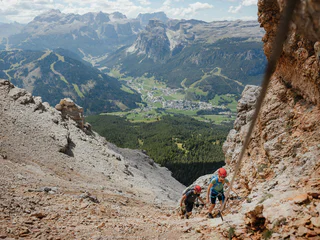
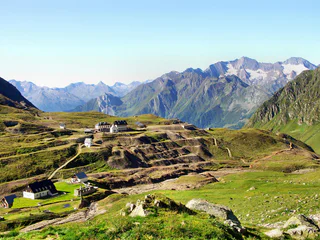
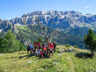
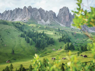
Vydejte se na úchvatné túry a výlety po krásné krajině Jižního Tyrolska. Prozkoumejte zázraky přírody, objevte skryté skvosty a cestou si vytvořte nezapomenutelné vzpomínky. Najděte si vybrané akce pro svou dovolenou:
Zvolte datum nebo rozmezí dat a vyhledejte probíhající a nadcházející akce během vašeho pobytu v Jižním Tyrolsku.
St.Leonhard in Passeier/San Leonardo in Passiria, Meran/Merano and environs
Approach to Ulfas to the parking space called "Kratzegg". Ascent on trail no. 2 across alpine meadows to the large cairn on the ridge and on to the summit. The descent is via the Ulfaseralm hut back to the parking space.
Attention: Good physical condition required!
Walking time: approx. 8 h (there & back) | difference in altitude: 1,350 m
The hike will be in German and Italian.
Rasen-Antholz/Rasun Anterselva, Dolomites Region Kronplatz/Plan de Corones
Experience a wonderful nature park hike in the natur park Rieserferner-Ahrn with our hiking guide Gilbert!
Tour: Staller Saddle (2.052) > Mount "Kleines Mandl" (2.591)
Rest station: Restaurant Obersee and Hexenschenke at the Staller Saddle at the end of the tour
Walking time: approx. 4,5 - 5 hours (there and back)
Difficulty: medium
A hiking adventure to discover South Tyrol's mountains and get to know this unique, enchanting, panoramic world better.
Registration required in the tourist information office by 5 pm on the previous day. Limited number of participants.
Path to the Ulfaseralm. From there we head uphill to the Schartalm, where we stop for a bite to eat. Afterwards we take the "Hahnl" with us and here we start the descent to the "Waalerhütte" and return to the car park via the Ulfaser/Matatzer Waalweg.
Walking time: approx. 4 hours
Altitude metres: approx. 500 m
Moderately difficult hike
Feldthurns/Velturno, Brixen/Bressanone and environs
The panoramic high-level hike leads us through pine forests to beautiful high alpine pastures in the direction of the Radlsee lake, Brugger Schupfe and back to the Kühhof. Stop for refreshments at Klausner Hütte or Radlseehütte hut.
Start: 09:30 am Kühhof car park, hiking bus possible, walking time approx. 4 hours, height difference 430 m, moderately difficult hike, return at 4:30 pm Kühhof car park.
Minimum number of participants: 2 people.
Free of charge for guests of member accommodations, otherwise € 10.00 per person.
ONLY IN GERMAN AND ITALIAN!
Hiking through meadows and forests. Listen to the sounds of nature, breathe in the clear morning air, feel the tickle of wet grass and the first rays of sun on your skin. A special nature experience in the Merano 2000 hiking area. The breathtaking sunrise on the 'Spieler' peak rewards you for the effort you put into leaving your warm bed. After the moderately difficult hike (480 metres altitude), we enjoy a hearty breakfast with South Tyrolean products at the Meranerhütte.
ONLY IN GERMAN!
From Sulden, we take the Kanzel chairlift up to 2.340 m, where our hike to the Düsseldorfer Hut begins. We will be rewarded with a stunning view of the Ortler and the Königspitze before descending into the valley.
Walking time: approx. 4,5hours
Difference in altitude: up 400 m| down 850 m
Difficulty: difficult
St.Leonhard in Passeier/San Leonardo in Passiria, Meran/Merano and environs
Journey to Pfelders/Plan, from there via the Faltschnalalm hut to the Spronserjoch with a short descent to the first Spronser lakes. Continue to Grünjoch and turn right over the ridge to the panoramic summit. The way back is via the Lazinser Alm hut.
Walking time: approx. 8 h (there & back) | difference in altitude: 1,200 m
The hike will be in German and Italian.
The Conturines cave, discovered in 1987, is 200 metres long and located at 2750 metres above sea level. The bones of a previously unknown species of bear - Ursus ladinicus - were found in the cave. It is the highest find in the world. To reach this fascinating place, you have to climb one thousand metres of altitude difference, some of it on steep scree, but the sight is well worth it.
Itinerary: Capanna Alpina (1726 m) - Col de Locia - Conturines cave (2750 m) - Capanna Alpina
Difficulty: difficult
Meeting: 8.00 a.m. San Cassiano - Capanna Alpina (parking for a fee)
Return: approx. 3.30 p.m.
Altitude diff.: ↑↓ approx. 1100 m
Distance: approx. 9 km
Walking: approx. 7 hours
Lunch: packed lunch
P.S.: Good physical condition and experience in the mountains is required! Cave temperature: 0°C.
Domestic animals and strollers are not allowed.
Information and reservation at the tourist offices or online within the day before (limited places).
During the event photos or video footage may be taken for the purpose of documentation and promotion of the event and the region. The footage may be used and published on websites, on social networks and on media in compliance with the data protection regulations.
Powered by Karpos.
Guided circular hike along the "Hirtensteig" – tracing the herders on the Rittner Horn in german or italian language.
Meeting point: 13.15 at the bus stop Tann (Bus 166 from Klobenstein/ train station at 1.03 p.m.). Length of tour: 6 km, walking time: 4 hours. Height difference: 200 m in ascent and descent, medium difficulty hike. Price hike: € 15, free with RittenCard. Equipment: Hiking equipment, rain gear, drink, fruit on the way.
The nature and landscape guide Karl Unterhofer tells about the Pastoral life and alpine pasture system - then and now, ... and offers the possibility to try the "Goaslschnöllen" yourself
The journey takes place by taxi to Aica di Fiè. From here, we hike with our guide Herbert to the Tschafon plateau. The ascent to the Tschafon hut passes through shady coniferous forests. From the hut, we reach the peak of Mount Balzo and enjoy the view. After the lunch break, we descend towards Wuhnleger with a view of the Rosengarten massif and leisurely return to the starting point. The return journey is again by taxi.
Height difference in ascent: 630 m
Height difference in descent: 630 m
Distance: 10,5 km
Villanders/Villandro, Brixen/Bressanone and environs
The local hiking guide will lead you on this easy circular hike to the show distillery. It goes past high moors, watercourses and alpine meadows. On the way, the lunch break is held alternately at a hut.
Free of charge for holders of the Guest Pass and guests of member establishments. (Transportation and lunch not included)
Relaxing time out amidst the unspoilt nature of the Ahrntal mountains. Guided relaxation hike to an idyllic alpine pasture. Breathing sequences to get your own energy flowing. Barefoot, if liked. Followed by a small lunch with homemade snacks. Guided tour by Angelika Kirchler.
Children: minimum age 12 years
Dogs: allowed (with leash and muzzle)
Difficulty level: medium
Price with Südtirol/Alto Adige Guest Pass holiday region Ahrntal valley € 35.00; normal price € 80.00
A hiking adventure to discover South Tyrol's mountains and get to know this unique, enchanting, panoramic world better.
Registration required in the tourist information office by 5 pm on the previous day. Limited number of participants.
Welschnofen/Nova Levante, Dolomites Region Eggental
Via the Schafsteig to the Rotwand Hut in the Catinaccio with hiking guide Ferdinand Pardeller
Ascent from Welschnofen | Nova Levante with the public bus to Vigo di Fassa. From there we take the Ciampedie cable car. From Ciampedie we hike moderately steeply along the narrow sheep trail (Vial de le Feide) to the foot of the Mugoni, an imposing rocky peak in the Catinaccio massif. From there the trail leads us past the Roda di Vael and the Window Tower to the Roda di Vael hut. Descent to the Karerpass | Passo Costalunga and return by bus to Welschnofen | Nova Levante to the starting point.
Start: 09:00 am, bus stop Welschnofen | Nova Levante centre | Duration: 6 h | Walking time: 4 h | Difference in altitude: ascent: 347 m, descent: 601 m | Length: 8,6 km | Difficulty: moderately difficult | with refreshment stop at the Roda di Vael hut (not included) | it is recommended to bring a lunch pack and drinks | Equipment: trekking shoes, warm clothing, headgear, rain protection | Costs: cableway Ciampedie Euro 15,00/adult, Euro 10,50/junior (born after 01.01.2007) or Eggental Mountain Pass, transport by public bus | Price participation: Euro 10.00/adult; Euro 5.00/junior (6-13 years) | Number of participants: min. 2, max. 15 | Booking & information: until 5:00 pm the day before the event at the tourist offices, tel. +39 0471 619 500 or online at eggental.com/events.
The events start PUNCTUALLY, delays cannot be considered because of the program.
ATTENTION: guided hike is held in GERMAN AND ITALIAN LANGUAGE!
At the Gampen Pass, we visit a military bunker from World War II. Afterwards, we hike along a gravel road and then a footpath. The trail leads upward in switchbacks until we cross a wide valley at the foot of the small Laugenspitze. Continuing with a gentle ascent, we reach the small idyllic Gfrillneralm where we take a break. There, we can enjoy wonderful views of the Dolomites. After that, a pleasant road leads down to the Gampenstraße, from where we take the bus back to Lana.
Metres in altitude: approx. 400 m
Total walking time: 4 hours
Difficult hike: moderate
Moos in Passeier/Moso in Passiria, Meran/Merano and environs
Fancy a varied hike where you can experience the secrets of nature?
This guided hike in the Texelgruppe Nature Park takes you into a landscape characterised by water and stone - powerful, lively and full of geological features.
The start is at the Seeberkehre (Timmelsjochstraße). From there it goes to the Seeberalm hut, then down to Rabenstein/Corvara and the former Kummersee lake, which was formed after a landslide in 1401 and disappeared in 1774 after its last eruption.
Along the European long-distance hiking trail E5, we follow the Passer, the main river of the Passeiertal Valley, which is not only a natural habitat but also a source of energy. The trail leads to Moos/Moso. A geological highlight is the "Schneeberger Zug" with its striking limestone formations. This area is part of the fascinating "Colourful Series", a geological zone full of colours, folds and structures. The destination is the village of Moos/Moso.
You will be accompanied by a trained nature park guide, who will provide fascinating insights along the way: which plants grow here? How does the landscape change throughout the year? Which animals are native, and how do humans and nature share this space? The tour is part of a series of nine guided hikes through the Texelgruppe Nature Park - each with a different destination, each path offering new perspectives.
Walking time: approx. 4 h | Difference in altitude: approx. 80 m in ascent and approx. 930 m in descent
The event will be in German and Italian.
Kastelruth/Castelrotto, Dolomites Region Seiser Alm
If you hadn’t realised it before, when the first rays of sun timidly appear on the surrounding peaks you will see just how much it was worth getting up so early. A sunrise mountain tour on the Schlern mountain is a very special experience.
A shuttle bus will take you to the Saltner Tschapit hut, where the ascent begins. Equipped with headlamps, you will arrive at Monte Petz (2,564 m) at around 6:50, in perfect time for the sunrise. After this natural spectacle, a well-earned breakfast awaits you at the Schlernhaus mountain refuge, also known as the “castle in the mountains”.
DURATION OF THE HIKE (WITHOUT REST)
2:15 h from Saltner Tschapit hut to Monte Pez (4,8 km; 755 m uphill)
15 min from Monte Pez to Schlernhaus mountain refuge (0,6 km; 110 m downhill)
1:25 h from Schlernhaus mountain refuge to Saltner Tschapit hut (4,2 km; 645 m downhill)
1:15 h from Saltner Tschapit hut to Compatsch (4,1 km, 135 m uphill, 128 m downhill)
This moderately difficult hike leads through picturesque meadows and woods to an untouched panoramic jewel, where you can enjoy a fantastic view on the villages of Colfosco and Corvara framed by the majestic Sassongher.
Itinerary: Colfosco (1645 m) - Crëp de Sela (1868 m) - Crëp de Munt (2152 m) - Ütia Crëp de Munt hut (2000 m) - Corvara
Difficulty: medium
Meeting: 9.30 a.m. Colfosco Tourist Office
Return: approx. 4.00 p.m.
Altitude diff.: ↑ approx. 530 m ↓ approx. 630 m
Distance: approx. 10 km
Walking: approx. 3,5 hours
Lunch: packed lunch or break in a mountain hut
The guide speaks Italian and German.
Domestic animals and strollers are not allowed.
Information and reservation at the tourist offices or online within the day before (limited places).
During the event photos or video footage may be taken for the purpose of documentation and promotion of the event and the region. The footage may be used and published on websites, on social networks and on media in compliance with the data protection regulations.
Powered by Karpos.
Tramin an der Weinstraße/Termeno sulla Strada del Vino, Alto Adige Wine Road
If you are looking for nature and adventure, so join us to the guided hiking tours around Tramin. Twice a week in September and October professional alpine guides show you the nicest places of our country.
Registration within one day before in the tourist office.
For Tramin guests for free an with the activ&mobil card. Minimum of two persons
The last ice age shaped the landscape of Stelvio National Park. How can we still recognize the impact of the ice age today? What is a "rock glacier?" Participants in this guided hike will learn about white gold and read about the traces of the Ice Age.
• Duration: 6 hours
• You need: Outdoor clothing, backpack (with spare clothes, rain jacket, snacks and drinks), hiking boots
• Difficulty: difficult
• Difference in hight: ca. 700 HM;
• Tour length| ca. 10,5 km
• Stop at the Rifugio Canziani for lunch
• Shuttle bus: Free transport by shuttle bus from S. Valburga in Val d’Ultimo to the starting point and back. Departure at 9:00 AM from S. Valburga (Tourist Office). The shuttle will make the same stops as the public transport service. When booking, please indicate your chosen stop.
Hike among spruce and pine trees along several stations dedicated to the goddesses of nature. To explore the cycles and healing powers of nature. With a detour of the Mooseum at Ahornach/Acereto
Difficulty: easy - moderate difficulty
Difference in altitude: approx. 220 meters
Meeting point: Bus stop Tobl, Ahornach/Acereto
Returns: from Ahornach/Acereto centre back by bus
Dogs: allowed
Accessible by public transportation
THE GUIDE SPEAKS GERMAN AND ITALIEN!
By bus, we travel through Lana to the Gampen Pass. From there, we hike through the forest to the Laugen Lake and continue to the Little Laugen Peak (2297 m), where an indescribable panoramic view awaits us. We return via the Laugen Alm to the Gampen Pass, where the bus is waiting for us.
Hiking time: approximately 4 hours
Travel time: approximately 1 hour by coach to the starting point
Elevation gain: up 700 m | down 700 m
Difficulty: difficult
Moos in Passeier/Moso in Passiria, Meran/Merano and environs
Approach to Stuls/Stulles. Ascent on trail no. 14 to the mountain meadows above Stuls, where a fixed rope makes the ascent easier over the last few metres. The descent follows the trail via the Hochalm and the Egger-Grub-Alm huts back to the parking space.
Walking time: approx. 6 h (there & back) | Difference in altitude: 1,067 m
The hike will be in German and Italian.
Kastelruth/Castelrotto, Dolomites Region Seiser Alm
The trip starts from Kastelruth towards Bolzano, continuing on the motorway in the direction of Trento, passing the picturesque Lake Toblino and through the impressive Arco Valley to Limone sul Garda.
In Limone, you will get off the bus and have free time to spend the day as you wish.
At 4:00 p.m., you will be picked up again at the Info Point in Malcesine.
The transfer from Limone to Malcesine is by boat (not included in the trip price).
The one-way fare is €9.00 per person.
The return trip goes via Torbole and Riva del Garda, then back to the motorway via Rovereto in the direction of Kastelruth.
Arrival in Kastelrutn at approx. 18:00 hrs.
Taxi company: Taxi Albert
Registration:
When registering, it is necessary to indicate the boarding point. If you want to get on at a bus stop that is not on the list, you must register with the tourist office.
Departure times:
Bus station Kastelruth 08:30
Bus stop Telfen 08:33
Bus station Siusi 08:40
Bus stop Hotel Vigilerhof 08:43
Bus stop St. Konstantin/Camping 08:44
Bus stop St. Anton 08:47
Bus station Völs 08:50
We ask for punctuality! The guide speaks German and Italian.
Guided tour of the Terlan's wine path. You will hear (only in German language) about the history of winegrowing, the vineyard plots, the varieties, the vine-training systems, and the estates and mansions you will encounter on the path.
Space: 2 hours. Participation is free of charge.
Registration required at the Terlan Tourist Office.