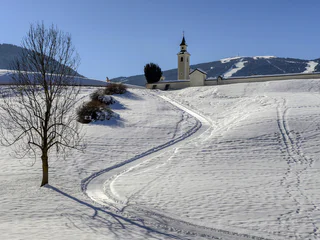
Südtirol Guide App Logo
Přeskočit na obsah

přidáno k oblíbeným

odebráno z oblíbených

Jejda! Došlo k problému, zkuste to prosím znovu

Vytváří se váš účet

Váš účet byl úspěšně vytvořen a nyní jste přihlášeni

Jste úspěšně přihlášeni!

Váš účet byl úspěšně vytvořen, ale nepodařilo se nám vás automaticky přihlásit

Jste odhlášeni

Filtr
Vybrané filtry
    Úroveň obtížnosti
    Doba trvání
    Vzdálenost v km

    Všechny zimní túry v Gsiesertalu/Val Casies

    Poznejte klidnou stránku Gsiesertalu/Val Casies během zimní turistiky po vyšlapaných cestách. Objevte okouzlující vyhlídky, zasněžené lesy v tichých bočních údolích a užívejte si jen sebe a přírodu v absolutním tichu. Výlety na sněžnicích vás zavedou daleko od sjezdovek a lyžařských vleků do nedotčených lesů. Výlety na sněžnicích a zimní turistika se stanou zážitkem.

    Výsledky
    Summer
    Winter hike: Panoramic hike in the Val Casies/Gsiesertal Valley
    Gsies/Valle di Casies

    Short hike at the head of the valley

    Starting point: Val Casies/Gsiesertal Valley – S. Maddalena, Head of the valley (1465 m)
    Distance: 2 km
    Descent: circular hike
    Walking time: 00:40 h
    Difficulty: easy
    Difference in altitude: 80 m
    Tobboganing possibility: no

    Obtížnost: nízká
    73 m nadmořská výška
    0h:34 min doba trvání
    Hiking
    Winter hike: The Taistner Alm hut in Tesido 2012 m
    Welsberg-Taisten/Monguelfo-Tesido

    A well-known hut with a beautiful view

    Starting point: Monguelfo-Tesido – Tesido, parking lot above the mountain farm Mudler (1620 m)
    Distance: 4,1 km
    Descent: along the ascending route
    Walking time: 01:30 h
    Difficulty: easy
    Difference in altitude: 392m
    Tobogganing possibility: yes / difficulty easy
    Information: also feasible with snow shoes or touring skis

    Obtížnost: střední
    420 m nadmořská výška
    1h:30 min doba trvání
    Summer
    Winter hike: A relaxing hike in the Val Casies/Gsiesertal Valley
    Gsies/Valle di Casies

    Circular hike at S. Martino

    Starting point: Val Casies/Gsiesertal Valley – S. Martino, tourist information office (1276 m)
    Distance: 2,7 km
    Descent: circular hike
    Walking time: 00:45 h
    Difficulty: facile
    Difference in altitude: 30 m
    Tobogganing possibility: no

    Obtížnost: nízká
    26 m nadmořská výška
    0h:40 min doba trvání
    Hiking
    Winter hike: Hiking amongst farms in Tesido
    Welsberg-Taisten/Monguelfo-Tesido

    Hike passing by characteristic farms

    Starting point: Monguelfo-Tesido – Tesido, tourist office (1206 m)
    Distance: 8 km
    Descent: circular route
    Duration: 02:40 h
    Difficulty: medium
    Difference in altitude: 300 m
    Possibility of sledding: no

    Obtížnost: střední
    300 m nadmořská výška
    2h:30 min doba trvání
    Hiking
    Winter hike: The Uwald Alm hut in the Val Casies/Gsiesertal Valley 2042 m
    Gsies/Valle di Casies

    Where you get the most beautiful view of the valley

    Starting point: Val Casies/Gsiesertal Valley – S. Maddalena, Head of the valley (1465 m)
    Distance: 5 km
    Descent: along the ascending route
    Walking time: 01:30 – 02:00 h
    Difficulty: medium
    Difference in altitude: 577 m
    Tobboganing possibility: yes
    Information: also feasible with snowshoes or touring skis  

    Obtížnost: střední
    577 m nadmořská výška
    2h:00 min doba trvání
    Hiking
    Winter hike: The Kradorfer Alm hut in the Val Casies/Gsiesertal Valley 1704 m
    Gsies/Valle di Casies

    Hiking fun for all ages

    Starting point: Val Casies/Gsiesertal Valley – S. Maddalena, Head of the valley (1465 m)
    Distance: 3,5 km
    Descent: along the ascending route
    Walking time: 01:10 h
    Difficulty: easy
    Difference in altitude: 239 m
    Tobogganing possibility: yes / easy difficulty
    Information: also feasible with snowshoes or touring skis

    Obtížnost: nízká
    239 m nadmořská výška
    1h:00 min doba trvání
    Hiking
    Winter hike: Stroll in Monguelfo
    Welsberg-Taisten/Monguelfo-Tesido

    Easy hike in the direction of Braies Valley

    Starting point: Monguelfo-Tesido – Monguelfo, tourist information office (1087 m)
    Distance: 6 km
    Descent: circular hike
    Duration: 01:30 h
    Difficulty: easy
    Difference in altitude: 60 m
    Possibility of sledding: no

    Obtížnost: nízká
    60 m nadmořská výška
    1h:31 min doba trvání
    Summer
    Winter hike: The Messnerhütte hut in the Val Casies/Gsiesertal Valley 1660 m
    Gsies/Valle di Casies

    Family friendly hike

    Starting point: Val Casies/Gsiesertal Valley – S. Maddalena, Head of the valley (1465 m)
    Distance: 3 km
    Descent: along the ascending route
    Walking time: 01:00 h
    Difficulty: easy
    Difference in altitude: 195 m
    Tobogganing possibility: yes / easy difficulty
    Information: also feasible with snowshoes or touring skis

    Obtížnost: nízká
    200 m nadmořská výška
    0h:49 min doba trvání
    Hiking
    Winter hike: Hike past farms in the Val Casies/Gsiesertal Valley
    Gsies/Valle di Casies

    Short hike at S. Martino

    Starting point: Val Casies/Gsiesertal Valley – S. Martino, tourist information office (1276 m)
    Distance: 4 km
    Descent: circular hike
    Duration: 01:30 h
    Difficulty: easy
    Difference in altitude: 50 m
    Tobogganing possibility: no

    Obtížnost: nízká
    42 m nadmořská výška
    1h:01 min doba trvání
    Summer
    Winter hike: Along the “Talblickweg” path in the Val Casies/Gsiesertal Valley
    Gsies/Valle di Casies

    The panoramic street of the Val Casies Valley

    Starting point: Val Casies/Gsiesertal Valley – S. Maddalena, Head of the valley (1465 m)
    Distance: 16,5 km
    Descent: using public transport
    Walking time: 05:00 h
    Difficulty: easy
    Difference in altitude: 200 m
    Tobboganing possibility: no
    Information: Depending on weather conditions: with freshly fallen snow only accessible with snow shoes.

    Obtížnost: nízká
    268 m nadmořská výška
    4h:28 min doba trvání
    Hiking
    Winter hike: Long hike at Colle in the Val Casies/Gsiesertal Valley
    Gsies/Valle di Casies

    Hiking on the sunny side of the valley

    Starting point: Val Casies/Gsiesertal Valley – Colle, Hotel Stoll (1225 m)
    Distance: 6.5 km
    Descent: circular route
    Walking time: 02:15 h
    Difficulty: easy
    Difference in altitude: 120 m
    Possibility of sledding: no

    Obtížnost: nízká
    142 m nadmořská výška
    2h:00 min doba trvání
    Hiking
    Winter hike: Panoramic hike in the Val Casies/Gsiesertal Valley
    Gsies/Valle di Casies

    Hike amongst characteristic hamlets: Schintlholz/Schintlholz, Hölzl, Prati di Tesido

    Starting point: Val Casies/Gsiesertal Valley – Colle, parish church (1260 m)
    Distance: 6 km
    Descent: along the same route or by public transport
    Duration: 02:00 h
    Difficulty: medium
    Difference in altitude: 300 m
    Possibility of sledding: no

    Obtížnost: nízká
    200 m nadmořská výška
    3h:00 min doba trvání
    Hiking
    Winter hike: Panoramic hike in Tesido
    Welsberg-Taisten/Monguelfo-Tesido

    Towards the Dolomites

    Starting point: Monguelfo-Tesido – Tesido, tourist office (1206 m)
    Distance: 3,5 km
    Descent: along the ascending route
    Duration: 01:00 h
    Difficulty: easy
    Difference in altitude: 171 m
    Possibility of sledding: no

    Obtížnost: nízká
    165 m nadmořská výška
    1h:00 min doba trvání
    Hiking
    Winter hiking along Ried, Lettner, Waldbrunn and Gailerhof in Monguelfo
    Welsberg-Taisten/Monguelfo-Tesido

    A hike along Ried, Lettner, Waldbrunn and Gailerhof and back to Welsberg

    Starting point: Monguelfo-Tesido – Monguelfo, bus stop in the Via Stazione 1087 m
    Distance: round hike of ca. 5 km
    Hiking time: 2 hours
    Level of difficulty: medium to difficult
    Altitude difference: 144 m

    Obtížnost: střední
    144 m nadmořská výška
    2h:00 min doba trvání
    Hiking
    Winter hiking: The Aschtalm hut in the Val Casies/Gsiesertal Valley 1950 m
    Gsies/Valle di Casies

    Hiking and sledding fun at “Hubi”

    Starting point: a) Val Casies/Gsiesertal Valley – S. Maddalena, Head of the valley (1465 m) b) Val Casies/Gsiesertal Valley – S. Maddalena, “Huben” cottages
    Distance: a) 3,3 km b) 3,8 km
    Descent: along the ascending route
    Walking time: a) 01:30 - 02:00 h b) 01:15 h – 01:30 h
    Difficulty: a) medium b) easy
    Difference in altitude: a) 485 m b) 410 m
    Tobboganing possibility: yes / medium difficulty
    Information: also feasible with snowshoes or touring skis | Tip: Snowshoe hike from Calsale "Huben (limited parking available) along Pfinn stream possible (01:00 h)

    Obtížnost: nízká
    485 m nadmořská výška
    1h:15 min doba trvání
    Hiking
    Winter hike: The Moos Alm hut in the Val Casies/Gsiesertal Valley 1477 m
    Gsies/Valle di Casies

    For winterlovers

    Starting point: Val Casies/Gsiesertal Valley – S. Maddalena, Head of the valley (1465 m)
    Distance: 0,5 km
    Descent: along the ascending route
    Walking time: 00:10 h
    Difficulty: easy
    Difference in altitude: 12m
    Tobogganing possibility: no
    Information: Directly at the cross country track

    Obtížnost: nízká
    11 m nadmořská výška
    0h:12 min doba trvání
    Hiking
    Winter hike: Hiking from Monguelfo to the dam of Valdaora
    Welsberg-Taisten/Monguelfo-Tesido

    Along the shores of the Rienza river to the Salla hamlets

    Starting point: Monguelfo-Tesido – Monguelfo, tourist information office (1087 m)
    Distance: 6 km
    Descent: circular hike
    Duration: 03:45 h
    Difficulty: medium
    Difference in altitude: 180 m
    Possibility of sledding: no

    Obtížnost: nízká
    327 m nadmořská výška
    4h:00 min doba trvání
    Summer
    Winter hike: Passing by historic farmsteads and farmhouses
    Gsies/Valle di Casies

    Circular hike to the head of the valley in the Val Casies/Gsiesertal Valley 

    Starting Point: Val Casies/Gsiesertal Valley – S. Maddalena, Head of the valley, Parish church (1400 m)
    Distance: 6 km
    Descent: circular hike
    Walking time: 01:50 h
    Difficulty: medium
    Difference in altitude: 175 m
    Information: Depending on weather conditions: with freshly fallen snow only accessible with snow shoes.

    Obtížnost: nízká
    222 m nadmořská výška
    1h:43 min doba trvání
    Hiking
    Winter hike: The Stumpfalm hut in the Val Casies/Gsiesertal Valley 2000 m
    Gsies/Valle di Casies

    Through a marvellous winter forest

    Starting point: Val Casies/Gsiesertal Valley – S. Maddalena, Head of the valley (1465 m)
    Distance: 5 km
    Descent: along the ascending route
    Walking time: 02:00 h Difficulty: medium
    Difference in altitude: 536 m
    Tobboganing possibility: yes / medium difficulty
    Information: also feasible with snowshoes or touring skis  

    Obtížnost: střední
    503 m nadmořská výška
    2h:00 min doba trvání
    Hiking
    Winter hike: To the Gallfallalm huts 1667m in the Val Casies/Gsiesertal Valley
    Gsies/Valle di Casies

    Hike from S. Martino to the Karbacher Tal Valley

    Starting point: Val Casies/Gsiesertal Valley – S. Martino, tourist information office (1276 m) or Karbacherhof farm (1425 m)
    Distance: 5 km
    Descent: same way as ascent
    Walking time: 01:50 h
    Difficulty: medium
    Difference in altitude: 391 m S. Martino | 242 m maso Karbacherhof
    Tobogganing possibility: no
    Information: Depending on weather conditions: with freshly fallen snow in parts only accessible with snow shoes.

    Obtížnost: nízká
    230 m nadmořská výška
    1h:30 min doba trvání
    1