
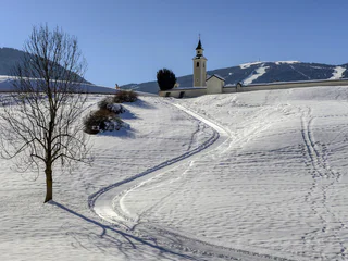
Winter hike: Panoramic hike in the Gsiesertal Valley
Colle/Pichl, Gsies/Valle di Casies
easy
Moeilijkheidsgraad
200 m
Hoogteverschil
3h:00 min
Duur
Leer de rustige kant van het Gsiesertal/Val Casies kennen tijdens winterwandelingen over gebaande paden. Ontdek betoverende uitzichtpunten, besneeuwde bossen in stille zijdalen en geniet alleen van jezelf en de natuur in absolute stilte. Sneeuwschoenwandelingen brengen je weg van de pistes en skiliften en in ongerepte bossen. Sneeuwschoenwandelen en winterwandelen worden een belevenis.
Colle/Pichl, Gsies/Valle di Casies
easy
Moeilijkheidsgraad
200 m
Hoogteverschil
3h:00 min
Duur
S. Maddalena/St. Magdalena - Casies/Gsies, Gsies/Valle di Casies
easy
Moeilijkheidsgraad
200 m
Hoogteverschil
0h:49 min
Duur
Monguelfo/Welsberg, Welsberg-Taisten/Monguelfo-Tesido
easy
Moeilijkheidsgraad
327 m
Hoogteverschil
4h:00 min
Duur
1/2
Valdaora di Mezzo/Mitterolang, Welsberg-Taisten/Monguelfo-Tesido
easy
Moeilijkheidsgraad
40 m
Hoogteverschil
1h:25 min
Duur
S. Maddalena/St. Magdalena - Casies/Gsies, Gsies/Valle di Casies
medium
Moeilijkheidsgraad
577 m
Hoogteverschil
2h:00 min
Duur
S. Maddalena/St. Magdalena - Casies/Gsies, Gsies/Valle di Casies
easy
Moeilijkheidsgraad
11 m
Hoogteverschil
0h:12 min
Duur
S. Maddalena/St. Magdalena - Casies/Gsies, Gsies/Valle di Casies
medium
Moeilijkheidsgraad
503 m
Hoogteverschil
2h:00 min
Duur
Monguelfo/Welsberg, Welsberg-Taisten/Monguelfo-Tesido
medium
Moeilijkheidsgraad
144 m
Hoogteverschil
2h:00 min
Duur
S. Maddalena/St. Magdalena - Casies/Gsies, Gsies/Valle di Casies
easy
Moeilijkheidsgraad
222 m
Hoogteverschil
1h:43 min
Duur
St. Magdalena/S. Maddalena - Gsies/Casies, Gsies/Valle di Casies
easy
Moeilijkheidsgraad
442 m
Hoogteverschil
2h:34 min
Duur
Monguelfo/Welsberg, Welsberg-Taisten/Monguelfo-Tesido
easy
Moeilijkheidsgraad
60 m
Hoogteverschil
1h:31 min
Duur
Colle/Pichl, Gsies/Valle di Casies
easy
Moeilijkheidsgraad
127 m
Hoogteverschil
1h:28 min
Duur
Colle/Pichl, Gsies/Valle di Casies
easy
Moeilijkheidsgraad
142 m
Hoogteverschil
2h:00 min
Duur
Tesido/Taisten, Welsberg-Taisten/Monguelfo-Tesido
medium
Moeilijkheidsgraad
320 m
Hoogteverschil
2h:30 min
Duur
S. Martino/St. Martin - Casies/Gsies, Gsies/Valle di Casies
easy
Moeilijkheidsgraad
42 m
Hoogteverschil
1h:01 min
Duur
S. Maddalena/St. Magdalena - Casies/Gsies, Gsies/Valle di Casies
easy
Moeilijkheidsgraad
104 m
Hoogteverschil
0h:43 min
Duur
S. Maddalena/St. Magdalena - Casies/Gsies, Gsies/Valle di Casies
easy
Moeilijkheidsgraad
239 m
Hoogteverschil
1h:00 min
Duur
S. Martino/St. Martin - Casies/Gsies, Gsies/Valle di Casies
easy
Moeilijkheidsgraad
230 m
Hoogteverschil
1h:30 min
Duur
S. Maddalena/St. Magdalena - Casies/Gsies, Gsies/Valle di Casies
easy
Moeilijkheidsgraad
485 m
Hoogteverschil
1h:15 min
Duur
Tesido/Taisten, Welsberg-Taisten/Monguelfo-Tesido
medium
Moeilijkheidsgraad
300 m
Hoogteverschil
2h:30 min
Duur
Tesido/Taisten, Welsberg-Taisten/Monguelfo-Tesido
medium
Moeilijkheidsgraad
420 m
Hoogteverschil
1h:30 min
Duur
S. Martino/St. Martin - Casies/Gsies, Gsies/Valle di Casies
easy
Moeilijkheidsgraad
26 m
Hoogteverschil
0h:40 min
Duur
Tesido/Taisten, Welsberg-Taisten/Monguelfo-Tesido
easy
Moeilijkheidsgraad
165 m
Hoogteverschil
1h:00 min
Duur
Tesido/Taisten, Gsies/Valle di Casies
easy
Moeilijkheidsgraad
268 m
Hoogteverschil
4h:28 min
Duur
S. Maddalena/St. Magdalena - Casies/Gsies, Gsies/Valle di Casies
easy
Moeilijkheidsgraad
73 m
Hoogteverschil
0h:34 min
Duur
Bedankt voor je inschrijving!
Inschrijving al actief
Bevestig je inschrijving
Om je inschrijving te voltooien, open de e-mail die we je net hebben gestuurd en klik op de bevestigingslink.
Niet gevonden? Kijk ook even in je spammap.
We hebben gezien dat je je probeerde aan te melden voor de nieuwsbrief, maar je e-mailadres is al geregistreerd. Je blijft onze aanbiedingen, tips en inspiratie voor je vakantie ontvangen.
Je hebt je al geprobeerd in te schrijven voor onze nieuwsbrief maar deze nog niet bevestigd. We hebben je de e‑mail zojuist opnieuw gestuurd. Controleer je inbox en je spammap en bevestig nu.


