Südtirol Guide App Logo
Přeskočit na obsah

přidáno k oblíbeným

odebráno z oblíbených

Jejda! Došlo k problému, zkuste to prosím znovu

Vytváří se váš účet

Váš účet byl úspěšně vytvořen a nyní jste přihlášeni

Jste úspěšně přihlášeni!

Váš účet byl úspěšně vytvořen, ale nepodařilo se nám vás automaticky přihlásit

Jste odhlášeni

Filtr
Vybrané filtry
    Úroveň obtížnosti
    Doba trvání
    Vzdálenost v km

    MTB výlety a stezky

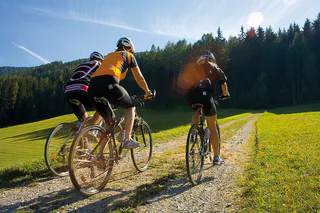
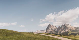
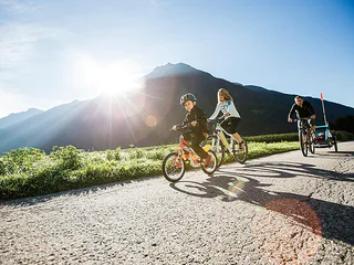
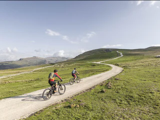
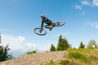
    Čistý adrenalin před působivou horskou scenérií: MTB výlety v Jižním Tyrolsku nabízejí zábavu pro každého bikera. Na cestu, vyrazte! Jako freerider prozkoumejte údolí ve Vinschgau, objevte Alpe di Siusi, největší alpskou louku v Evropě, na dvou kolech nebo pocítíte vítr při plynulém sjezdu z Kronplatzu. Jihotyrolské MTB túry jsou zárukou zábavy z jízdy a zážitků z přírody.

    Výsledky
    Mountain bike
    Gumperle Tour
    Prad am Stilfser Joch/Prato allo Stelvio, Vinschgau/Val Venosta

    This short tour named after the surname of this area leads from Prato/Prad which is characterised by Romanesque period, across the beautiful meadow path above the granaries of the Venosta Valley to Agumes/Agums and to Montechiaro/Lichtenberg. A tarmacked trail leads upwards, gaining a little altitude, up to the Lichtenberg Castle and the Pinethöfe farms. We cycle past the Pinethöfe and a little later, turn left into the flowy S0 to S1 trail, which merges with a small tarmacked road at the Wartamstein height, back to Prato

    Tip: Please do not cycle on the popular family hiking trail.

     
    Worth seeing: Castles like the former Lichtenberg Fortress, the parish church of Montechiaro with building features and frescos from the 13th century, the St. Christina chapel  (1575) with a chancel closed on three sides, wall paintings and shingle roof.

    Obtížnost: nízká
    235 m nadmořská výška
    7.6 Km vzdálenost
    E-MTB
    Ortler Bike Marathon - 111 km
    Graun im Vinschgau/Curon Venosta, Vinschgau/Val Venosta
    The toughest variant of the OBM with 111km distance and 3,905 hm. Suitable for experienced athletes who are looking for a challenge.

    Route: Graun in Vinschgau, St. Valentin auf der Haide, Dörfl, Alsack, Ulten, Spinaid, Malettes, Mösl, Matsch, Schlosshof, Lochhof, Churburg, Schluderns, Glurns, Mals, Burgeis, Marienberg Monastery, Stefanskirche, Klostersäge, Lataschg, Prämajur, Gstoderhof, Bruggeralm, St. Valentin auf der Haide, Schöneben Hütte, Kopferbrücke, Rescher Alm, Gravalada, Grünsee, Berggasthof Riatschhof, Naudersmühlen, Nauders Dorf, Bergkastel-Bergbahn valley station, Stieralm, Plamortböden, Etschquelle, Reschen, Graun im Vinschgau.
    Obtížnost: vysoká
    4238 m nadmořská výška
    110.9 Km vzdálenost
    Mountain bike
    Gungadria Tour
    Prad am Stilfser Joch/Prato allo Stelvio, Vinschgau/Val Venosta

    Leisurely tour through the enchanted Prato forest to the castle ruin above Cengles/Tschengls. A stop at a special cultural guest house.

    To reach the ruin of the Cengles Castle above the Venosta Valley, the trail leads from Prato/Prad in the Stelvio National Park in a south-easterly direction to the St. Johann church and further past the “Dürre Ast“ up to the Prato mountain farms. At the branch to Wittenberger Hof farm, the ground changes to gravel and a little later, the highest point has been reached (1,430m) at the streambed. During the descent on gravel and tarmac, the forest curtain opens up and with it, the view to the Tschengslburg castle ruin and the cultural landscape of the Venosta Valley covered with small squares. The view across green meadows on the other side of the valley with the sparse slopes and beautiful summits of the Monte Sole Mountain is, in any event, worthy of a stop to take a photo. You could stop in the Tschengelsburg, at Karl Perfler’s castle restaurant which has been developed to a cultural guest house. Then you leisurely pass the apple orchards and return to Prato at the foot of the imposing Tschenglser Hochwand mountain (3,376 m).

    Tip: The field name Gungadria originates from the “Tschrinwiesen” fields at the Nittbach stream. The Romanic term “concha” (muscle) signifies the round or oval area indentations or hollow forms.

    Obtížnost: střední
    573 m nadmořská výška
    16.6 Km vzdálenost
    Mountain bike
    Plankamodui Tour
    Prad am Stilfser Joch/Prato allo Stelvio, Vinschgau/Val Venosta

    Pleasant route across Montechiaro/Lichtenberg and the Platzhof farm into the 12er Trail.

    From Prato/Prad, the gateway to the Stelvio National Park and to Solda/Sulden, you proceed across the Suldenbach streem to Agumes/Agums and from there via a beautiful meadow path with view to the fields, castles and summits of the Upper Venosta Valley in northerly direction to Montechiaro/Lichtenberg. Here starts the ascent on asphalt up to the Lichtenberg Fortress and then on gravel further up to Adelheid Schöpf Lechner from the Platzhof farm (1,354 m). After a nice snack (Brotzeit) with a view towards the direction of Sluderno/Schluderns and on the 3,202 m high Allitzer Spitz peak, you reach the highest point after a few metres further uphill. A flowy descent on narrow and wide trails (S1 and S2), with a few technical tight turns – no risk of boredom. From the Agumsbergerhöfe farms we carry on rolling, soon on tarmac back into the direction of the starting point to the interesting aquaprad National Park visitor center and look forward to a leisurely drink containing electrolytes.

    Tip: The unusual name of the tour relates to a field name at the Agumser Berg mountain at the former climb from the Platzhof farm to Gawierg.

    Obtížnost: nízká
    506 m nadmořská výška
    11.3 Km vzdálenost
    Downhills
    Franz Trail
    Bruneck/Brunico, Dolomites Region Kronplatz/Plan de Corones

    #franzthetrail

    Franz is awesome and a bit reminiscent of Little Canada. Together with Hans, it is among the first completely hand-built trails at Kronplatz and absolutely not suited for newbies. And quite frankly, some of its sections will even make most pros break a sweat. Today, Franz is one of the coolest trails at Kronplatz – and a MTB dream come true for many riders. Where to find it? It branches off from the Herrnsteig trail a little above the Herzlalm inn.

    Length: 978 m

    Difference in altitude: 207 m

    Level: difficult

    Obtížnost: vysoká
    6 m nadmořská výška
    1.0 Km vzdálenost
    E-MTB
    Ortler Bike Marathon - 69 km
    Graun im Vinschgau/Curon Venosta, Vinschgau/Val Venosta
    After the 111km Variente, the 69km route of the OBM 2400 hm also demands everything from the athletes. Suitable for all who are looking for a challenge

    Route: Graun im Vinschgau, St. Valentin auf der Haide, Dörfl, Alsack, Ulten, Mals – St. Martin Kapelle, Burgeis, Kloster Marienberg, Stefanskirche, Klostersäge, Lataschg, Prämajur, Gstoderhof, Bruggeralm, St. Valentin auf der Haide, Schöneben Hütte, Kopferbrücke, Rescher Alm, Tendershof, Reschen, Graun im Vinschgau.
    Obtížnost: střední
    2537 m nadmořská výška
    68.7 Km vzdálenost
    E-MTB
    390 Eisacktal Valley-Dolomites region Seiser Alm link trail
    Völs am Schlern/Fiè allo Sciliar, Dolomites Region Seiser Alm

    The „Eisacktal Valley-Dolomites region Seiser Alm link trail“ connects the valley cycle path with the Seiser Alm/Val Gardena biking region and its villages Kastelruth, Seis am Schlern, Völs am Schlern, Tiers am Rosengarten and Seiser Alm.

    Obtížnost: střední
    689 m nadmořská výška
    19.9 Km vzdálenost
    E-MTB
    MTB Tour Plattner Alm
    Pfalzen/Falzes, Dolomites Region Kronplatz/Plan de Corones
    The tour starts at the sports field in Pfalzen and follows MTB Route 440 up to the charming Plattner Alm. From the starting point, you’ll begin on a paved road that gently winds through the green valley. Soon, you’ll reach a shaded forest area, where the fresh air makes for an enjoyable ride. The path passes by small clearings and offers views of the surrounding mountains. After a moderate climb, you’ll reach the first resting spot, ideal for a short break. Continuing uphill, the trail leads you past alpine meadows and picturesque alpine huts. In the final stretch, the path becomes a bit more challenging, and the effort is rewarded with even better viewpoints. At the top, the Plattner Alm awaits you with breathtaking panoramic views and a welcoming alpine hut where you can take a break and enjoy local specialties. The return follows the same route, giving you another chance to appreciate the diverse landscape from a new perspective.
    Obtížnost: vysoká
    966 m nadmořská výška
    11.0 Km vzdálenost
    E-MTB
    429 Variante Schnaggenkreuz Cross loop route I
    Völs am Schlern/Fiè allo Sciliar, Dolomites Region Seiser Alm

    At the Braunhof farm there is a connection from the Hofer Alpl hut loop tour to the entrance of the Schnaggenkreuz loop route at the Tasioler farm. So you can quickly and comfortably switch between the tours.

    Obtížnost: nízká
    0 m nadmořská výška
    376.0 m vzdálenost
    E-MTB
    Kaltern Bike MTB-Tour: "Penegal"
    Kaltern an der Weinstraße/Caldaro sulla Strada del Vino, Alto Adige Wine Road

    On the western side of the Etsch / Adige Valley, the glaciers from the last Ice Age left an almost vertical cliff up to 600 meters in height demarcated in the north by the Gantkofel / Monte Macaion and in the south by the Monte Roen. In the middle, there's the Penegal, with its transmission station visible from afar. The only suitable trail for cyclists from Kaltern / Caldaro to this summit takes about an hour, and is via the Mendel Pass Road. This route displays an average grade of only six to eight percent, thus allowing cyclists to adopt a nice, regular rhythm. However, if you want, you have the choice of instead taking the convenient Mendel / Mendola funicular. Once you've gotten to the pass, you'll still have to overcome the narrow, low-traffic road up to the summit – that'll take about half an hour. But then you're in for a handsome reward: A terrific panorama of Lake Caldaro and the entire "South of South Tyrol!" Now comes the challenging descent to Bait del Prinz. Some stretches of Trail No. 500 are bumpy, rocky, with roots growing across it; the trail leads mostly downhill, but there are also several short, exciting ascents. Once you've reached the Prinz Hut, you'll turn into a gravel trail veering downhill to the left and taking you to the Regole di Malosco – an alpine hut with a bill of fare boasting a variety of delicious Trentino specialties. Then proceed uphill for a bit along the gravel trail and then downhill to the Hotel Paradiso. From there, you should then take the road uphill to the Mendel Pass. After a short descent to the road, you'll turn into the New Mendel Ascent which has been especially established for cyclists. This trail is a relatively broad gravel forest path suitable for cyclists of all levels. It includes a couple of winding segments that will take you to the Boos Forest Road. At the bottom of the Forest Road, you can take the Hohl Trail (which has now been widened somewhat) which will lead you downhill to the edge of Kaltern / Caldaro – another highlight for bikers wishing to test their technical mettle. At this point, you can decide if you want to take the very beautiful trails and gravel paths of the detour via the Kaltern sports grounds and the Kardatsch Hiking Trail, all the way down to Lake Caldaro. From here, you will still have to manage another 180 meters of altitude differential back to the starting-point, but this descent is still quite rewarding. The trails down to the lake have a perfect "flow" and are not difficult to manage. All in all, the tour to the summit of the mighty Penegal represents a real highlight for cyclists with a good level of fitness, and boasts a heavenly panorama. The comfortable flow trail does not require a high technical level.


    Variants: The tour can be combined with the Malga Romeno tour.

    Mustn't be missed: The transmission station on the Penegal, the "Regole di Malosco" alpine hut, the fabulous panorama of Kaltern and Lake Caldaro, the "Unterland" district of South Tyrol, the Dolomites, and the mountains of the Non Valley.


    Obtížnost: vysoká
    1906 m nadmořská výška
    55.6 Km vzdálenost
    E-MTB
    Pitzinger Alm mtb round trip
    Pfalzen/Falzes, Dolomites Region Kronplatz/Plan de Corones

    The tour starts at the sports field in Pfalzen and follows MTB Route No. 441 through beautiful forested areas to the Pitzinger Alm, passing the Kofler am Kofel guesthouse and returning to the sports zone in Pfalzen. From the starting point, the route takes you along a paved road toward Platten, through green valleys and gentle hills. Soon, you reach a wooded area where the fresh mountain air makes the ride especially pleasant.

    The trail winds through dense vegetation, offering occasional open views of the surrounding mountains and valley. Some challenging sections include steeper climbs, but the breathtaking views and idyllic nature make every effort worthwhile.

    Once you reach the Pitzinger Alm, surrounded by an impressive mountain backdrop, it’s a perfect spot for a well-deserved break. The return route leads back to the Pfalzen sports zone, passing the Kofler am Kofel guesthouse, where you can savor local cuisine. Here, the views of the Kronplatz and the Dolomites are truly spectacular.

    Obtížnost: vysoká
    933 m nadmořská výška
    21.5 Km vzdálenost
    Mountain bike
    Dragon Trail
    Bruneck/Brunico, Dolomites Region Kronplatz/Plan de Corones
    New in summer 2022 in the Bike Park Kronplatz is the "Dragon Trail": the trail, over 2 kilometers long, winds along the hillside from the summit to the middle station of the Olang 1+2 lift. The highlight is definitely crossing the Dragon's Head and the Dragon's Tail, where you have a beautiful panorama of the surrounding Dolomites at the same time.
    Obtížnost: nízká
    5 m nadmořská výška
    2.0 Km vzdálenost
    E-MTB
    Kaltern Bike MTB-Tour: Kalterer Höhenweg nach Altenburg
    Kaltern an der Weinstraße/Caldaro sulla Strada del Vino, Alto Adige Wine Road

    This is a pleasant roundtrip circuit that will help to acquaint you with the vicinity. It's not quite 20 km long, and will provide you with a good impression of the experience of biking around the Kaltern / Caldaro area. This tour includes beautiful, flowing forest trails interrupted only by charming little lookout points where you can enjoy some wonderful panoramic views of the surrounding vineyards and Lake Caldaro.

    As the name of this route implies, the High-Altitude Trail will first take you uphill from Kaltern. You'll have to manage about 500 meters of altitude differential at the very start. From the town's central market square, you will ascend "through the villages" (the parts of town at higher elevations) – namely: Pfuss and St. Niklaus – up to the so-called "Kalterer Höhe" (high-altitude trail). From this high point, you take the Mendel Pass Road farther up to the Mendel Pass. But this main road is crossed only twice before the High-Altitude Trail really becomes true to its name in the forest and gains elevation until you cross the cableway leading to the Mendel Pass. Now comes the most-enchanting segment of this tour, as you proceed along forest paths and trails downhill until you come to the Ziegelstadel. While passing through the forest, you'll repeatedly come to little clearings where you can stop for a breather and take in the marvelous views. From the Ziegelstadel, you should now take a trail down to Altenburg, the perhaps quietest neighborhood in Kaltern. Altenburg is situated on a sun-drenched plateau above the lake, hidden behind the forest. This is the perfect opportunity for you to pause for refreshments at the Waldschenke Inn or to discover one of the stunning lookout points with a view of Lake Caldaro. The return trip from Altenburg takes you back to Kaltern, past the St. Anton Sports Center with its fun climbing facility. If you feel up to it, you might want to stop by and include a session of wall-climbing in your tour. Or, you can comfortably glide down the path to the central square of Kaltern. Once you've arrived, you might want to relax and enjoy a cup of cappuccino, or a glass of delicious Caldaro wine. What an apt way to conclude a pleasant journey through the many vineyards you've passed through on this tour!

    Variants: This tour can also be combined with the "Panorama" tour – part of which runs along the same High-Altitude Trail. You thus have a number of different options to choose from.


    Obtížnost: střední
    505 m nadmořská výška
    18.7 Km vzdálenost
    Downhills
    Fontana Trail
    Kastelbell-Tschars/Castelbello-Ciardes, Vinschgau/Val Venosta
    The Fontana Trail starts just below the Schartegg parking lot. The first section is a wooded trail and isn't technically demanding (S1), following the same route as the Wolf Trail. However, as from the Wolf Trail/Fountain Trail intersection the path becomes more challenging (S2). Closer to the valley the trail gradually increases in difficulty (S3). The trail has various points of access.
    Obtížnost: vysoká
    0 m nadmořská výška
    5.0 Km vzdálenost
    E-Bikes
    Valley Bike Path: Campo Tures-Brunico
    Sand in Taufers/Campo Tures, Ahrntal/Valle Aurina

    Who does not have a bicycle can rent a good bike in one of the various rental stations in Campo Tures/Sand in Taufers.

    Obtížnost: nízká
    47 m nadmořská výška
    17 Km vzdálenost
    Downhills
    Sigi Line
    Bruneck/Brunico, Dolomites Region Kronplatz/Plan de Corones

    Located in the lower section of the Herrnsteig trail and dotted with wide and flowing bends, this is the ideal line for riders looking for an alternative to root-covered “classic” trails.

    Level: medium

    Obtížnost: střední
    0 m nadmořská výška
    776.0 m vzdálenost
    E-Bikes
    Premstl-Stallwies Tour
    Martell/Martello, Vinschgau/Val Venosta

    Start at the visitor center culturamartell in Trattla and take the Val Martello path until Ganda and then towards Stallwies. Turn right above the Premstl inn and follow the road towards Radund. Take the forest road towards "Platzer Mahd". Continue on the forest road and enjoy the nature passing by mighty larches and lush mountain meadows. We warmly recommend you to stop at the Stallwies mountain inn that awaits you with excellent South Tyrolean cuisine. Return on the same route and don’t forget to make a detour to the "Suachbichl" viewpoint.

    Obtížnost: střední
    764 m nadmořská výška
    11.0 Km vzdálenost
    E-MTB
    Höll-Tour
    Partschins/Parcines, Meran/Merano and environs

    Route length in km: 17,9
    Vertical climb: ascent 373m – descent 1.156m
    Surface: asphalt, forest path, Single-Trail-section
    Required technical skills: S0/S1 – easy

    Obtížnost: nízká
    311 m nadmořská výška
    17.3 Km vzdálenost
    E-MTB
    430 Variante Schnaggenkreuz Cross loop route II
    Völs am Schlern/Fiè allo Sciliar, Dolomites Region Seiser Alm

    The 600 m long Hofer Alpl II variant is a connection from Moar Mühle to Peternaderhof farm, where you can enter in the Schnaggenkreuz loop rout or vice versa.

    Obtížnost: nízká
    0 m nadmořská výška
    599.0 m vzdálenost
    Downhills
    4-gewinnt-13 Trail
    Latsch/Laces, Vinschgau/Val Venosta

    Flowing, partially rough trail with wonderful views. You will definitely win on this legendary Laces trail.

    The famous trail no. 4 in combination with the panoramic and partially exposed trail no. 13 is a true enrichment. Start at the Malga di Laces mountain hut and go through the green forest landscape until the wayside cross where you turn right into trail no. 4. Continue on sometimes flowing and sometimes rough meadow and forest floor trails that wind through the forest until Plumargun and get you into the right trail mood. Don’t follow the steep and heavily washed out trail no. 4, which has been removed from the trail concept, but take the forest road and turn right into trail no. 13 below the distinctive tree. The slightly exposed flowing and narrow S2 trail turns into a heavy passage with some roots and debris towards the end. The view of the valley offers a wonderful panorama at sunset. Please note: “Share the Trail” sections on the hiking paths! The lower part of trail no. 4 from the forest road at Partschogg onwards as well as paths 4a and 4b are for hikers only!

    Obtížnost: střední
    0 m nadmořská výška
    4.5 Km vzdálenost
    E-MTB
    Ortler Bike Marathon - 46 km
    Graun im Vinschgau/Curon Venosta, Vinschgau/Val Venosta
    The 46km route is ideal for all athletes who do not want to miss out on a phenomenal panorama and are still looking for a challenge.

    Route: Graun im Vinschgau, St. Valentin auf der Haide, Staumauer, Innerkaschon, Schöneben Hütte, Kopferbrücke, Rescher Alm, Gravalada, Grünsee, Berggasthof Riatschhof, Naudersmühlen, Nauders Dorf, Talstation Bergkastel-Bergbahn, Stieralm, Plamortböden, Etschquelle, Reschen, Graun im Vinschgau.
    Obtížnost: střední
    1666 m nadmořská výška
    45.8 Km vzdálenost
    E-Bikes
    457 From picturesque heights to medieval town flair - from Kastelruth to Sterzing
    Kastelruth/Castelrotto, Dolomites Region Seiser Alm

    Moderate E-Bike Tour. Basic fitness required. Mostly paved paths. No special skills necessary. The starting point of the tour is accessible by public transportation.

    Kastelruth, idyllically located at the foot of the Dolomites, captivates with its historic village center and the distinctive Kastelruth church tower. From here, you can enjoy breathtaking views of the surrounding mountains. This place, steeped in history, is truly a gem of the region.

    The bike tour takes you down into the Eisack Valley, where you’ll ride through a partly mountainous landscape while enjoying stunning views of forests and meadows. At your destination, Sterzing, you’ll discover a charming old town with splendid townhouses and Gothic churches that highlight the city’s medieval atmosphere. Sterzing is not only a historical treasure—it also offers numerous cultural attractions, such as the impressive Reifenstein Castle.

    Obtížnost: střední
    984 m nadmořská výška
    65.3 Km vzdálenost
    E-MTB
    398 E-bike tour Plafötsch – Haniger
    Tiers am Rosengarten/Tires al Catinaccio, Dolomites Region Seiser Alm

    Challenging hut-tour in Tiers am Rosengarten.

    This tour, which is especially recommended for e-bikers because of its 800 meters of altitude difference, leads past alpine huts which offer refreshments. The tour offers a fantastic view of the Rosengarten massif with the impressive Vajolet towers.

    Obtížnost: střední
    793 m nadmořská výška
    16.7 Km vzdálenost
    E-MTB
    Kaltern Bike MTB-Tour: "Jochgrimm"
    Kaltern an der Weinstraße/Caldaro sulla Strada del Vino, Alto Adige Wine Road

    This tour combines an easy but long ascent along the former railroad line with a stunning view of the Dolomites – including the Latemar and the Rose Garden – and with a wonderful, relatively gentle and fluid downhill trip that speed demons will love. There are practically no difficulties requiring a high level of technical skill, and there are certainly no segments where you'll have to dismount and push your bike. So if you have a high level of physical fitness and if you start out early, you will certainly complete this 90-km marathon – especially since you can breeze along almost 40 km in both directions on dedicated bicycle trails. From the starting-point at the parking lot in the Kellereistrasse, you first proceed along the bicycle trail to Auer / Ora and on to Neumarkt / Egna. After a short and relatively steep ascent through vineyards, you come to the village of Montan / Montagna. The trail then follows the incline along the former Fleims / Fiemme Valley railroad line. You'll climb approx. 800 meters of altitude differential with a grade of no more than 6%. Shortly after you reach Kaltenbrunn / Fontanefredde, you'll turn off to the left via a couple of wooden staircases and then continue along the narrow, low-traffic road to Radein / Redagno and from there along a wide, gently inclined gravel road up to the Jochgrimm. Once you've reached the Jochgrimm Inn (at an elevation of 2,000 meters above sea-level), you'll be rewarded with a fantastic view of the Dolomites: The mighty chain of peaks extending from the Latemar and Rose Garden with the Vajolett Towers is a visual feast – an unforgettable view. There is a beautiful, somewhat wider trail about 10 km in length, always slightly downhill, over alpine meadows and all the way to the Weissenstein Monastery along these imposing mountain cliffs. This ascent is highly enjoyable. You can enjoy this fluid downhill trip, and there are practically no difficulties requiring a high level of technical skill. From the Weissenstein Monastery – a well-known place of pilgrimage – a gravel road first leads you down a steep downhill grade. Just before Deutschnofen / Nova Ponente, you'll have to then accomplish a short opposing climb before descending into the marvelous Branten Valley. You will then proceed at first down a steep gravel trail and in part over streamlets paved with jagged stone (Attention: plenty of flat stones) into a narrow gorge with in part vertical cliff walls. The trail will take you down to Leifers / Laives in the Etsch / Adige Valley. This is a unique experience – not only because of the giant cliff walls, but also because it is pleasantly cool in this valley even on hot summer days. Once you've arrived in Leifers, you have two alternatives to get back to Kaltern: You can either take the bike trail to the south around the Mitterberg / Monte di Mezzo and then past Lake Caldaro, or proceed to the north towards Bozen / Bolzano and then along the bike path towards Meran / Merano and Kaltern. You should base your decision on the wind direction: In the afternoon (especially when the weather is fine), it will be blowing relatively strong from the south. The route towards Bozen is a little bit longer, but quicker when you have a southerly wind to your back. Especially ambitious bikers are free to take the "Coyote Pass," allowing you to accumulate another 150 meters of steep uphill meters of altitude differential.

    Variants: Via Truden / Trodena, you can reach the "Cisloner Alm", "Kanzel," and "Trudner Horn" routes.

    Mustn't be missed: The former Fleims / Fiemme Valley railroad line, the Maria Weissenstein place of pilgrimage, the village of Deutschnofen / Nova Ponente, a beautiful panoramic view of the Weisshorn and Schwarzhorn, the Latemar, the Rose Garden, and the Schlern / Sciliar.

    Obtížnost: vysoká
    3808 m nadmořská výška
    91.4 Km vzdálenost
    E-Bikes
    Circuit Klobenstein - Lengmoos
    Ritten/Renon, Bolzano/Bozen and environs
    A mtb route runs as a ring route between the railstation Klobenstein to Lengmoos and from there to the Ritten Arena or the nearby starting point of the tour.
    Obtížnost: nízká
    68 m nadmořská výška
    2.4 Km vzdálenost
    Downhills
    Scheibenkofel Trail
    Latsch/Laces, Vinschgau/Val Venosta

    Along this short trail, mountain bikers must conquer an altitude of 210 m over a distance of 1.1 km, and the trail is therefore suitable for both beginners and those making a comeback. Along the way, bikers can enjoy a wonderful view of Annenberg Castle and San Martino in Monte.

    Obtížnost: střední
    0 m nadmořská výška
    1.2 Km vzdálenost
    E-MTB
    Kaltern Bike MTB-Tour: Trodena
    Kaltern an der Weinstraße/Caldaro sulla Strada del Vino, Alto Adige Wine Road

    Another absolutely superlative tour in the vicinity of Kaltern / Caldaro: Almost 80 km in length and requiring a high level of physical fitness, this route leads – after arriving via the bicycle path from Kaltern to Neumarkt / Egna – along the old railroad tracks to Kaltenbrunn / Fontanefredde and then on to Truden / Trodena. As you proceed along the course of the former Fleims / Fiemme Valley railroad line, you will climb approx. 800 meters of altitude differential with a grade of no more than 6%. This railroad line – stretching from Auer / Ora to Predazzo – was built during World War I by Russian prisoners of war to transport men and matériel from the Etsch / Adige Valley to the Fleims / Fiemme Valley and towards the front. After the conclusion of the war, this small railroad transported chiefly wood and passengers until it was finally shut down in the 1960s due to shrinking profitability. All that remained was the perfectly established route which, today, serves as a gravel road called the "former Fleims / Fiemme Valley railroad line" or "ex ferrovia". Because the locomotives back then were unable to manage a grade of more than five or six percent, this route is perfect for cyclists – you will be able to gently ascend the slope. The old railway tunnels – which seem like gloomy holes when you first approach them – shouldn't startle you: motion detectors will sense your approach and automatically switch on the lights. As you approach Kaltenbrunn / Fontanefredde, you'll turn off of the railway route and proceed a short distance uphill along the road to Truden. This gravel road is not overly steep and so is easily managed, and will take you up to the Ziss Saddle; this represents the transition to Altrei / Anterivo. Continuing to pedal uphill. Shortly before your reach the Horn Alm, you'll be treated to a fantastic long-distance view eastwards. Now you can enjoy the entire Fleims / Fiemme Valley and the majestic craggy towers of the Pale di San Martino looming behind the Rolle Pass. At an elevation of about 1,700 meters above sea-level, the Horn Alm is a very popular destination for cyclists coming from Bozen / Bolzano and its vicinity. From here, you'll take a short ramp uphill before you pass by Lake Schwarz and Lake Weiss on a gravel path downhill towards Gfrill / Cauria. This charming little hamlet is situated high above the Etsch / Adige Valley and affords a breathtaking view of the magnificent Dolomiti di Brenta. You will first proceed along the old and partially paved rural paths through alpine meadows and then downhill via Trail No. 7 – a forest trail requiring a high degree of technical skill and with almost 1,000 meters of altitude differential that will take you to Laag / Laghetti. The return trip to Kaltern in the afternoon is especially pleasurable when the weather is fine because that's when there's a strong southly wind (the so-called "Ora") blowing through the Etsch / Adige Valley that will act as a tailwind, giving you a little extra "push." It's thus no problem to achieve a speed of 40 km/h on average. All in all, the Trudner Horn is a superlative tour featuring great panoramas. However, it requires a medium-good level of technical skill and relatively good physical fitness.

    Variants: In Truden / Trodena, you can decide whether you'd rather opt for the somewhat shorter and easier "Cisloner Alm" or "Kanzel" tours.

    Mustn't be missed: The former Fleims / Fiemme Valley railroad line, Lake Weiss and Lake Schwarz, the villages of Truden / Trodena and Gfrill / Cauria.

    Obtížnost: vysoká
    1904 m nadmořská výška
    74.8 Km vzdálenost
    E-MTB
    Ortler Bike Marathon - 29 km
    Graun im Vinschgau/Curon Venosta, Vinschgau/Val Venosta
    With 29 km - the easiest of the 4 possible courses. Suitable for beginners who like to enjoy the view and the landscape in peace.

    Route: Graun im Vinschgau, St. Valentin auf der Haide, Staumauer, Innerkaschon, Schöneben Hütte, Kopferbrücke, Rescher Alm, Tendershof, Reschen, Graun im Vinschgau.
    Obtížnost: nízká
    810 m nadmořská výška
    29 Km vzdálenost
    Downhills
    Schöneben Trail
    Graun im Vinschgau/Curon Venosta, Vinschgau/Val Venosta

    The Upper Belpiano Trail is a special trail, it is perfectly adapted in the landscape and has challenging parts for all single trail-lovers. The trail starts at the mountainstation Belpiano and goes trough forests down to the brach-off in direction to the 3-Country-Trail. The character changes only insignificantly in the lower part. Wonderful cross-country skiing and deep views of Lake Resia make the Schöneben Trail an unforgettable experience - an experience that can be repeated over and over again thanks to the Schönebenbahn.

    Obtížnost: střední
    0 m nadmořská výška
    3.4 Km vzdálenost
    1 2 3 4 5 6 7 8 9 10 11 12 13 14