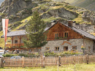
Přeskočit na obsah

přidáno k oblíbeným

odebráno z oblíbených

Jejda! Došlo k problému, zkuste to prosím znovu

Vytváří se váš účet

Váš účet byl úspěšně vytvořen a nyní jste přihlášeni

Jste úspěšně přihlášeni!

Váš účet byl úspěšně vytvořen, ale nepodařilo se nám vás automaticky přihlásit

Jste odhlášeni

Filtr
Vybrané filtry
    Úroveň obtížnosti
    Doba trvání
    Vzdálenost v km

    MTB výlety a stezky

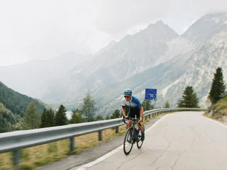
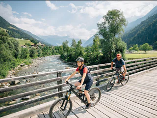
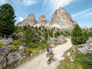
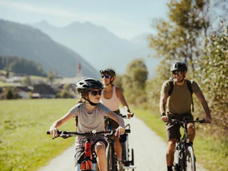
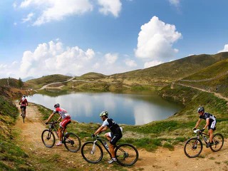
    Čistý adrenalin před působivou horskou scenérií: MTB výlety v Jižním Tyrolsku nabízejí zábavu pro každého bikera. Na cestu, vyrazte! Jako freerider prozkoumejte údolí ve Vinschgau, objevte Alpe di Siusi, největší alpskou louku v Evropě, na dvou kolech nebo pocítíte vítr při plynulém sjezdu z Kronplatzu. Jihotyrolské MTB túry jsou zárukou zábavy z jízdy a zážitků z přírody.

    Výsledky
    E-MTB
    Round trip Rieserferner
    Rasen-Antholz/Rasun Anterselva, Dolomites Region Kronplatz/Plan de Corones

    Antholz Niedertal > Antholzer See > Staller Sattel > Klammljoch > Rein in Taufers > Sand in Taufers > Bruneck > Rasen > Antholz Niedertal.

    Obtížnost: vysoká
    2122 m nadmořská výška
    91.4 Km vzdálenost
    Downhills
    Scheibenkofel Trail
    Latsch/Laces, Vinschgau/Val Venosta

    Along this short trail, mountain bikers must conquer an altitude of 210 m over a distance of 1.1 km, and the trail is therefore suitable for both beginners and those making a comeback. Along the way, bikers can enjoy a wonderful view of Annenberg Castle and San Martino in Monte.

    Obtížnost: střední
    0 m nadmořská výška
    1.2 Km vzdálenost
    E-MTB
    Uphill Gsteier
    Algund/Lagundo, Meran/Merano and environs
    Obtížnost: střední
    1105 m nadmořská výška
    68.1 Km vzdálenost
    E-Bikes
    Cycling and Sightseeing: Leuchtenburg/Castelchiaro Round Tour at Lake Caldaro
    Auer/Ora, Alto Adige Wine Road
    The Leuchtenburg cycling round tour starts at Klughammer on Lake Caldaro and covers a distance of approximately 24.9 km with an elevation difference of about 170 m. The total ascent is around 290 m. This tour is suitable for touring bikes, trekking bikes, city bikes, and mountain bikes and primarily runs on paved, low-traffic roads. The best times for this tour are spring, late summer, autumn, and winter, with the route being particularly beautiful from mid to late April during the blooming season.
    Obtížnost: střední
    278 m nadmořská výška
    24.8 Km vzdálenost
    E-Bikes
    To Bruneck
    Bruneck/Brunico, Dolomites Region Kronplatz/Plan de Corones

    On the Pustertal cycling route from the Antholz Valley to Bruneck.

    Obtížnost: nízká
    124 m nadmořská výška
    11.4 Km vzdálenost
    E-MTB
    423 Schlern-Rosengarten Ronda clockwise
    Kastelruth/Castelrotto, Dolomites Region Seiser Alm

    Circumnavigation of the Schlern and Rosengarten massifs with breathtaking views of the Dolomites and the regions of Seiser Alm/Alpe di Siusi, Val d'Ega/Eggental and Val di Fassa. An 80 km long, moderately difficult tour that is just as doable with a normal MTB as with an e-bike.

    ATTENTION: path [519] partially closed. Detour from Moena via [519A] to Tal Crist and then along path [519] to Passo Costalunga/Karerpass.

    Information about the timetables and tickets of the summer lifts: www.seiseralm.it/cablecars

    Obtížnost: střední
    2704 m nadmořská výška
    79.3 Km vzdálenost
    E-Bikes
    From Aldein to Jochgrimm – A Mountain Bike Tour Through South Tyrol’s Natural Paradise
    Aldein/Aldino
    The mountain bike tour from Aldein / Lerch to Auer-Leger Alm near Jochgrimm traverses some of the most spectacular landscapes of South Tyrol. Spanning a total distance of about 30 km with an elevation gain of approximately 450 m, the route blends asphalt and predominantly gravel paths, with a consistent incline of about 10%. In addition to the physical challenge, cyclists are rewarded with the natural beauty of the Dolomites, diverse flora, and the geological uniqueness of the Geoparc Bletterbach, a UNESCO World Heritage site. The best months for this tour are late spring, summer, and autumn when nature is at its most vibrant.
    Obtížnost: střední
    558 m nadmořská výška
    10.6 Km vzdálenost
    E-MTB
    249 Hofer Alpl loop route
    Völs am Schlern/Fiè allo Sciliar, Dolomites Region Seiser Alm

    This tour takes you along forest roads through masses of woodland to the Schlern-Rosengarten nature reserve. The trail leads past the Völser Weiher Lake and the Tuff Alm hut mountain hut to the Hofer Alpl on the slopes of the Schlern.

    Obtížnost: střední
    684 m nadmořská výška
    16.6 Km vzdálenost
    E-Bikes
    E-Bike Tour Albeins-Nafen-St. Peter-Ranui
    Villnöss/Funes, Dolomites Region Villnösstal

    Enjoy mountain bike tours also on steeper trails with the latest e-bike. Even beginners will be impressed by the electric mobility! Explore effortlessly the Geisler mountain landscape with an E-Bike. It’s emission-free, climate-friendly and without being stiff and sore.
    E-Bikes are for everyone due to the very simple operation. Overcome steep inclines with ease and cycle into the wind with a smile on your face, because that makes your bike trip even more fun.

    Obtížnost: střední
    1082 m nadmořská výška
    23.1 Km vzdálenost
    E-Bikes
    To the Malga Vitelli/Kälberalm
    Stilfs/Stelvio, Vinschgau/Val Venosta

    The mountain bike tour to the Malga Vitelli/Kälberalm is an easy tour, which leads through the forest to an alpine pasture. Since the tour follows a forest path, it is suitable for e-bikers.

    Obtížnost: nízká
    223 m nadmořská výška
    1.2 Km vzdálenost
    E-Bikes
    Furkelpass / Passo Furcia
    Al Plan/San Vigilio, Dolomites Region Kronplatz/Plan de Corones

    From the Antholz Valley to the Furkelpass/Passo Furcia (Altitude difference: 728 m | Lenght: 10,2 km)

    Obtížnost: vysoká
    832 m nadmořská výška
    14.2 Km vzdálenost
    Mountain bike
    Dragon Trail
    Bruneck/Brunico, Dolomites Region Kronplatz/Plan de Corones
    New in summer 2022 in the Bike Park Kronplatz is the "Dragon Trail": the trail, over 2 kilometers long, winds along the hillside from the summit to the middle station of the Olang 1+2 lift. The highlight is definitely crossing the Dragon's Head and the Dragon's Tail, where you have a beautiful panorama of the surrounding Dolomites at the same time.
    Obtížnost: nízká
    5 m nadmořská výška
    2.0 Km vzdálenost
    E-Bikes
    To Sand in Taufers to the starting point of the Waterfalls Reinbach
    Rasen-Antholz/Rasun Anterselva, Dolomites Region Kronplatz/Plan de Corones

    On the Pustertal cycling route from the Antholz Valley to Bruneck and then in direction Ahnrtal to Sand in Taufers to the starting point of the waterfalls Reinbach. From there you can visit the waterfalls on foot.

    Obtížnost: střední
    167 m nadmořská výška
    32.9 Km vzdálenost
    E-Bikes
    To the view of the Three Peaks
    Toblach/Dobbiaco, Dolomites Region Kronplatz/Plan de Corones

    On the Pustertal cycling path to Toblach and ahead in direction Cortina till the View of the 3 Peaks.

    Obtížnost: střední
    562 m nadmořská výška
    30.8 Km vzdálenost
    E-Bikes
    To Ried - Castle Lamprechtsburg and to Bruneck
    Rasen-Antholz/Rasun Anterselva, Dolomites Region Kronplatz/Plan de Corones

    To Ried and passing the castle Lamprechtsburg to Bruneck. On the Pustertaler cycling route back to the Antholz Valley.

    Obtížnost: střední
    446 m nadmořská výška
    24.6 Km vzdálenost
    E-Bikes
    To the Malga Stelvio di Sopra/Oberen Stilfser Alm
    Stilfs/Stelvio, Vinschgau/Val Venosta

    The mountain bike tour leads along a forest path to the Malga Stelvio di Sopra/Oberen Stilfser Alm, which makes it ideal for e-bikers. At the end of this relatively easy tour, a managed alpine hut awaits you, with its own alpine dairy and refreshment facilities.

    Obtížnost: nízká
    504 m nadmořská výška
    9.5 Km vzdálenost
    E-Bikes
    Pustertal Valley bike route to Mühlbach
    Rasen-Antholz/Rasun Anterselva, Dolomites Region Kronplatz/Plan de Corones

    From the Antholz Valley to Mühlbach along the Pustertal Bike Route

    Obtížnost: střední
    202 m nadmořská výška
    37.3 Km vzdálenost
    E-Bikes
    To the Rifugio Forcola/Furkelhütte
    Prad am Stilfser Joch/Prato allo Stelvio, Vinschgau/Val Venosta

    The mountain bike tour to the Rifugio Forcola/Furkelhütte is a wonderful tour to a hut with a breathtaking view and the possibility to stop for refreshments. As the tour runs through a forest path it is very suitable for e-bikers.

    Obtížnost: vysoká
    1628 m nadmořská výška
    40.2 Km vzdálenost
    Mountain bike
    MTB Tour Circular track Monte San Candido/ Innichberg
    Innichen/San Candido, Dolomites Region 3 Zinnen

    Tour 022

    Starting in San Candido/Innichen you cycle along the Pustertal Valley Cycle Trail to Dobbiaco/Toblach. After crossing the village Dobbiaco you follow the direction of "Costa dei Nosellari/Haselsberg" (on an asphalt road), passing several mountain farms. Past Feichterhof Guesthouse and the Hotel Schopfenhof (refreshment). You follow the Via Monte San Candido/Innichbergstraße way till you reach the Maso Stauder/Stauderhof (refreshment). You cycle on on the Via Monte Versciaco/Vierschachberg way to get to the Restaurant da Kathi/Jaufen (refreshment). Here you follow the way downhill to Prato alla Drava/Winnebach and you return on the Drava Cycle Path to San Candido/Innichen.

    Along the round there exits the possibility to interrupt the tour and to ride back to San Candido.

    This tour is also suitable for e-bikes.

    Obtížnost: střední
    557 m nadmořská výška
    26.3 Km vzdálenost
    Mountain bike
    298a Tour San Giacomo-Rifugio Firenze
    S.Crestina Gherdëina/Santa Cristina Val Gardana, Dolomites Region Val Gardena

    A great tour with a mix of history, nature park landscape and breathtaking views. This tour, which is the clockwise version of the Regensburger-Hütte tour, is particularly suitable for bikers who are not yet very familiar with mountainbiking. Of course, it is still not a walk in the park, because you should have some uphill and downhill riding skills. The St. Jakob’s Church is the first highlight of the tour: the small church, the oldest in Val Gardena, is located in the middle of the forest and only the church spire towers above the trees of the Rasciesa Forest. The legend of Count Jakob and the wonderful view of the Sassolungo group lend this place something magical. The rest of the tour runs through the Puez/Geisler Nature Park: pure nature, a beautiful Dolomite landscape and numerous places to stop and enjoy the delicious South Tyrolean food in traditional mountain huts. Most of the route is on gravel roads, although some steeper sections uphill and especially downhill should not be underestimated.

    All in all, a great ebike and mountain bike package to enjoy!

    Obtížnost: nízká
    779 m nadmořská výška
    23.4 Km vzdálenost
    E-Bikes
    Around the Kronplatz
    Rasen-Antholz/Rasun Anterselva, Dolomites Region Kronplatz/Plan de Corones

    Rasen > Olang > Furkelpass > Enneberg > Maria Saalen > Reischach > Ried > Rasen

    Obtížnost: vysoká
    1309 m nadmořská výška
    47.9 Km vzdálenost
    E-Bikes
    Redensberg - Aschbach - Nasen
    Rasen-Antholz/Rasun Anterselva, Dolomites Region Kronplatz/Plan de Corones

    Antholz Niedertal > Redensberg > Aschbach > Nasen > Antholz Valley

    Obtížnost: vysoká
    583 m nadmořská výška
    25.7 Km vzdálenost
    E-Bikes
    Around the yoke
    Villnöss/Funes, Dolomites Region Villnösstal

    Starting point: St. Peter, kilometres: 10.3 km; altitude difference: 324 m; altitude of starting point: 1145 m; altitude of end: 1145 m; Best season: May to October

    Tour description: The starting point of the tour is the village centre of St. Peter in the Villnöss valley. Here the route first passes by St. Jakob on an asphalted road. This tour leads you along the slopes of the foresty mountain, which parts the Afer and the Villnöss Valleys. After you reach the beautifully situated “Jochhöfe” (farm houses), you make your way across the saddleback on the northern side. You will be rewarded with a panoramic view to Brixen. After about 3 km of forest road, you return to the south side, past the Tschaufisserhöfe farmsteads to Coll. Crossing the road Coll, continue to the Gsoier Bild and via the Sunnseitenweg back to St. Peter.

    Obtížnost: střední
    410 m nadmořská výška
    10.4 Km vzdálenost
    E-MTB
    MTB tour to the Wurzer Alm Mountain Hut
    Hafling/Avelengo, Meran/Merano and environs

    Delightful mountain bike tour (number 262) through meadows and forests to the Wurzer Alm Mountain Hut.

    Obtížnost: střední
    524 m nadmořská výška
    15 Km vzdálenost
    E-Bikes
    Algund - Meran - Passeier Valley
    Algund/Lagundo, Meran/Merano and environs

    From Algund to Meran in the direction of the Passeier Valley. Before you come to the Zenoberg bridge, which leads across the Gilf canyon, turn right uphill to the Passer dam. The cycle path leads you mostly on gravelled road along the river Passer, which you must cross (bridges) several times. Passing the villages of Riffian, Saltaus and St. Martin. The road is well marked and without extended uphill runs until St. Leonhard.

    Obtížnost: nízká
    488 m nadmořská výška
    42.2 Km vzdálenost
    E-Bikes
    To Welsberg
    Welsberg-Taisten/Monguelfo-Tesido, Dolomites Region Kronplatz/Plan de Corones

    Along the Pustertal cycling route to Welsberg / Monguelfo.          

    Obtížnost: střední
    153 m nadmořská výška
    16.2 Km vzdálenost
    Mountain bike
    424 Schlern-Rosengarten Ronda counterclockwise
    Welschnofen/Nova Levante, Dolomites Region Eggental

    This challenging MTB tour takes you around two majestic mountains in the South Tyrolean Dolomites: the Rosengarten | Catinaccio and the Schlern | Sciliar.

    On 88 km and 2,500 metres of ascent, the full-day tour offers a breathtaking panorama of picturesque alpine meadows, dense forests and imposing, rugged rock faces as well as peaks that rise steeply into the sky.

    Obtížnost: vysoká
    2517 m nadmořská výška
    92.3 Km vzdálenost
    E-MTB
    Altrei/Antrevio Panorama Tour
    Altrei/Anterivo
    The Altrei circuit is an easy beginner tour, perfect for novice riders and those looking for a leisurely biking experience. The route covers approximately 13.90 km with an elevation gain of about 462 m, primarily on gravel forest roads. With an estimated riding time of about 1.5 hours, this tour offers spectacular insights into the natural diversity of the Trudner Horn Nature Park, known for its unique flora. The tour is especially recommended in late spring, summer, and autumn.
    Obtížnost: nízká
    447 m nadmořská výška
    11.6 Km vzdálenost
    1 2 3 4 5 6 7 8 9 10 11 12 13