Südtirol Guide App Logo
Skip to content

added to favourites

removed from favourites

Oops! Something went wrong. Try again

Your account is being created

Your account has been successfully created and you are now logged in

You’ve been logged in successfully!

Your account was created successfully, but we couldn't log you in automatically

You are logged out.

Filter
Selected filters
    Level of difficulty
    Duration
    Distance in KM

    MTB tours and trails

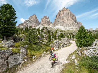
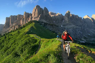
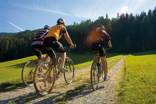
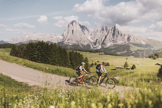
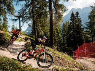
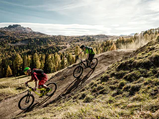
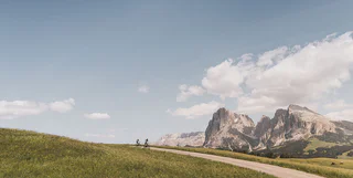
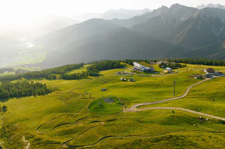
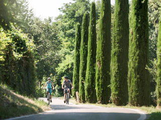
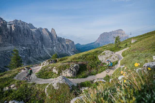
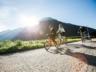
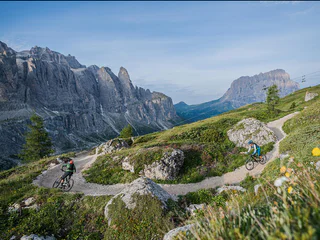
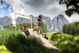
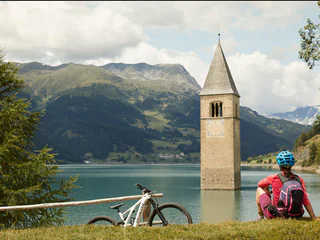
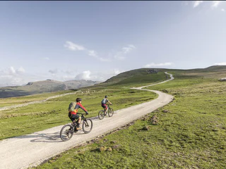
    Pure adrenaline in front of an impressive mountain scenery: MTB tours in South Tyrol offer fun for every biker. On the trail, get going! Explore the valley sides in Vinschgau as a freerider, discover the Alpe di Siusi, Europe's largest high alpine pasture, on two wheels or feel the wind on a flowing descent from Kronplatz. South Tyrol's MTB tours guarantee riding fun and nature experience. 

    Results
    Mountain bike
    Squirrel (2)
    Sexten/Sesto, Dolomites Region 3 Zinnen
    Light line. Flat trail with large curve, small natural elements like roots and stones.
    Difficulty: easy
    0 m elevation gain
    0h:00 min duration
    E-Bikes
    Grauner Alm alpine pasture Tour
    Graun im Vinschgau/Curon Venosta, Vinschgau/Val Venosta

    Nestled between the Endkopf "Jaggl" (2,627 m) and Pleisköpfl (2,425 m) lies the destination, the Grauner Alm alpine pasture, at 2,173 m. Start the tour in Graun at 1,500 m. For a quick warm up, follow the road into the Langtauferer valley. After 250 m, turn right over the bridge and pedal up through the shady Arluiwald forest on a mainly pleasant incline on the alpine path to the Grauner Alm alpine pasture. There is a possibility to park your mountain bike at the mountain pasture and continue on foot via hiking trail no. 10 to the summit of the Endkopf (2,652 m). Duration of hike: approx. 2.5 hours (ascent and descent). On the hiking path to the peak, it's possible to spot some rare edelweiss flowers and marmots. Lying in the grass on the slope, enjoy the sensational panorama and head back down to the valley via the alpine path to stop by the village for a good meal.

    Difficulty: medium
    676 m elevation gain
    0h:00 min duration
    E-Bikes
    Planeiler Alm alpine pasture Tour from St. Valentin
    Graun im Vinschgau/Curon Venosta, Vinschgau/Val Venosta
    The tour starts at the dam in St. Valentin. In the beginning, the route runs on an asphalt road through St. Valentin to Dörfl to the fisherman's houses and on to Alsack. Here turn left to Plawenn and then take the forest road on the right towards Planeiler Alm. Up to the Planeiler Alm alpine hut you have to really pedal uphill to reach the stopover after about 8 km. On the way enjoy the view of the Malser Haide, the Marienberg monastery and the Ortler group. The alpine hut offers some fresh milk and the traditional South Tyrolean bacon - Speck. With a full stomach, take the alpine path in the direction of Planeil valley to the Planeil stream called - Puni. After a rough, quite steep descent, reach the quaint village of Planeil. From Planeil, the asphalt road leads back to Ulten and Alsack and back to St. Valentin dam.
    Difficulty: easy
    970 m elevation gain
    0h:00 min duration
    Downhills
    Plamort Trail
    Graun im Vinschgau/Curon Venosta, Vinschgau/Val Venosta
    Far above, it leads across the picturesque and namesake Plamort plateau past the famous tank barrages. The Plamort Trail crosses the border between Austria and Italy and ends at the historic bunker complex.
    Difficulty: easy
    30 m elevation gain
    0h:00 min duration
    E-Bikes
    Resia Lake Round
    Graun im Vinschgau/Curon Venosta, Vinschgau/Val Venosta

    This route is suitable for a leisurely excursion, for families, and for mountain bike or e-bike tours for warm-up. The Resia lake can be cycled in both directions. Almost exclusively on asphalt, start along the cycle and gravel path from the famous church tower in Graun northwards to Reschen - past the sailing boats waiting for wind. Don't cycle straight forward to the Austrian state border. Instead, follow the cycle path in Reschen towards the western lakeside, past the Schöneben valley station, and calmly tackle the incline along the lake. The route is leisurely - until the southern lakeside with the dam wall and there is a fantastic view over the Malser Haide and King Ortler (3,905 m). At the dam, turn north and enjoy the panorama with the lake and the approaching mountains back to Graun. If the wind is strong, kiters and sailors can be spotted on Lake Reschen. There are cozy stops along the lake at the Sciuri at the Schöneben valley station, at the taverns Greinhof and Giernhof, at the new kitestation or at the businesses in Reschen and Graun.

    Difficulty: easy
    70 m elevation gain
    0h:00 min duration
    Mountain bike
    Locust (3b)
    Sexten/Sesto, Dolomites Region 3 Zinnen
    Option of Trail n° 3:

    Medium difficulty line with natural elements like roots and stones, tight curves and wooden elements.

    Difficulty: easy
    1 m elevation gain
    0h:00 min duration
    E-MTB
    Circumnavigation of Anterivo
    Altrei/Anterivo
    The Altrei Loop is an ideal tour for beginners and leisure cyclists. Covering nearly 14 kilometers, it follows well-maintained gravel forest paths through the Trudner Horn Nature Park, one of South Tyrol’s most biodiverse regions. With moderate ascents and stunning views, it provides a relaxing outdoor experience. The best time to ride is late spring, summer, and autumn.
    Difficulty: medium
    455 m elevation gain
    0h:00 min duration
    E-MTB
    Altrei/Anterivo-Malga Monte Corno-Altrei/Anterivo
    Altrei/Anterivo

    Starting at the town hall square in Anterivo we drive through the village towards the Hotel Waldheim, and then we turn left towards Prà dal Manz. The route continues on easy forest trails and leads uphill until it reaches the Passo Cisa (1489m). By continuing, we arrive at the Malga Monte Corno (1710m), the highest point of the tour. We follow the pleasant declining road which brings us back to the starting point in the centre of Anterivo.
    Tour Nr. 8

    Possible Restaurant stops: Malga Monte Corno


    Difficulty: medium
    568 m elevation gain
    0h:00 min duration
    Downhills
    Giern Trail
    Graun im Vinschgau/Curon Venosta, Vinschgau/Val Venosta

    Sulla parte inferiore del trail Belpiano, all'ultimo incrocio con la pista da sci, il facile Giern Trail porta in direzione di San Valentino e Giern. Il Giern Trail è il collegamento con il lago di Resia e termina al maso Giernhof. Da lì si può pedalare sulla pista ciclabile per San Valentino.

    Difficulty: easy
    50 m elevation gain
    0h:00 min duration
    Downhills
    Grein Trail
    Graun im Vinschgau/Curon Venosta, Vinschgau/Val Venosta

    Anche questo single trail ha tanto da offrire. Parte sopra Spin e rappresenta un interessante raccordo per San Valentino e per la funivia della malga San Valentino; vi accompagnerà lungo il crinale sempre in direzione sud. L'imbocco si raggiunge alla fine della parte inferiore dello Spin Trail. 

    Difficulty: medium
    250 m elevation gain
    0h:00 min duration
    Downhills
    Haideralm Trail
    Graun im Vinschgau/Curon Venosta, Vinschgau/Val Venosta

    On the Haideralm Trail the trails of the 3-Country region shows there full power and technical level. This trail is the most difficult trail. The trail passes directly under the cable car from the mountain station to the place San Valentio/St. Valentin. With the necessary bike-driving skills and technical knowledge the Haideralm Trail is a real big hit for all Enduro-fans.

    Difficulty: difficult
    628 m elevation gain
    0h:00 min duration
    Downhills
    Gerry Trail
    Graun im Vinschgau/Curon Venosta, Vinschgau/Val Venosta
    The Gerry Trail makes the hearts of experienced bikers beat faster. Very playful, it winds its way down the valley and offers many a technical challenge. But: every spot can be easily bypassed and the lower part is more relaxed to master.
    Difficulty: medium
    150 m elevation gain
    0h:00 min duration
    Mountain bike
    Snake (2a)
    Sexten/Sesto, Dolomites Region 3 Zinnen
    Option of Trail n°2:

    Light line. Flat trail with large curve, small natural elements like roots and stones.

    Difficulty: medium
    2 m elevation gain
    0h:00 min duration
    E-MTB
    Kaltern Bike MTB-Tour: Steintal large
    Kaltern an der Weinstraße/Caldaro sulla Strada del Vino, Alto Adige Wine Road

    It's hard to believe that the Mitterberg / Monte di Mezzo – this oblong, heavily forested mountain situated between the Etsch / Adige Valley and lake Caldaro – is crisscrossed by more than 600 km of trails, but it's true! The network of bike trails here is so complicated that you'll have to take care to maintain your bearings. The expansive Stein Valley is actually only a shallow depression near the highest point of the Mitterberg – which has an altitude of about 650 meters, and at the summit of which there is a large antenna station. You begin the ascent by first cycling downhill from Kaltern / Caldaro on the bicycle path towards Lake Caldaro, but after a few meters, you'll have to take a sharp left turn into a forest trail which is asphalted at the bottom. At the beginning, there is an only slight uphill grade. But starting at the Montiggl Plateau, it becomes much steeper. When you've gotten a little farther, a gravel trail starts. This gravel trail is only slightly uphill, and will take you to the entrance to the expansive Stein Valley. The route through the Stein Valley is virtually level, so you'll encounter nothing requiring any significant technical skill. The big, moss-covered boulders in the forest will catch your eye; they are found on both sides of the forest trail, and give the valley its name. Once you've gotten to the other side of the Stein Valley, you'll have two options to pedal downhill: The following description applies to the easy asphalt trail (which is nonetheless off limits for motor vehicles). Once you've descended, you can pedal along the level road to the west of the Montiggl Lakes towards Eppan. From there, you should take the bicycle trail along the former railroad line and bike back to Kaltern. In the summertime, the Montiggl Lakes are a popular destination for outdoor swimming, and you can enjoy a slice of delicious, home-made pie and cake in any one of the beach cafes. But please note the large number of pedestrians and hikers you'll encounter along the way to the lakes when the weather is nice. All in all, the Stein Valley is an easy mountainbike tour and, because it will take you mostly through shadowy forest, is to be preferred on hot days.

    Variants: This tour can also be combined with the "Girlan / Cornaiano" tour.

    Mustn't be missed: The Montiggl Lakes.

    Difficulty: medium
    389 m elevation gain
    0h:00 min duration
    Downhills
    Lower Spin Trail
    Graun im Vinschgau/Curon Venosta, Vinschgau/Val Venosta

    Before setting off on this tour, it is legitimate to think about the delicious Kaiserschmarren at the Rescher Alm. Follow the cycle path along the lakeshore from Reschen towards the Schöneben valley station. From the valley station, cycle uphill on the main road, in the direction of Rojen and then in the direction of St. Valentin to the hamlet of Spin. Shortly after the Spin´s farm, take a sharp right onto the forest and meadow path. In the forest, bend the way north above lake Resia and the Rojen road past a small forest lake (1,850 m). Follow the forest road, meet the Rojen road a little later and follow it to the trendy Rescher Alm hut. Here, at an altitude of 2,000 m, with a splendid view from the terrace, enjoy one of the best lunches. From the Rescher Alm alpine hut, continue north along the forest road, down to Tenders, where the Tendershof farmhouse invites for refreshment. From here, it is not far to the final destination: Reschen. Tip: For enduro enthusiasts: there is the option of rocking down via the 3-Länder Trail in the direction of Nauders to the Mutzkopf. From Mutzkopf, take one of the trails to Nauders.

    Difficulty: medium
    5 m elevation gain
    0h:00 min duration
    Mountain bike
    Lizard (2b)
    Sexten/Sesto, Dolomites Region 3 Zinnen
    Option of Trail n°2:

    Light line. Flat trail with large curve, small natural elements like roots and stones.

    Difficulty: medium
    2 m elevation gain
    0h:00 min duration
    Mountain bike
    Zirmtrail
    Graun im Vinschgau/Curon Venosta, Vinschgau/Val Venosta
    A literal highlight: The green Zirmtrail (S0) starts at 2,500 metres and winds beautifully over 5 kilometres through the alpine landscape down to the Bergkastel high plateau. It is not only one of the easiest, but also one of the most beautiful and varied trails in the Alps, serving up fun for trail novices and endurists alike. Peppered with countless undulations and curves, jumps and stone fields. That's why the Zirmtrail is also the preferred warm-up loop for 3-country enduro riders. It was built completely without foreign materials and with its single trail character it blends naturally into the landscape.
    Difficulty: easy
    310 m elevation gain
    0h:00 min duration
    E-MTB
    MTB-Tour Hunters Lodge (002)
    Sexten/Sesto, Dolomites Region 3 Zinnen

    This tour starts from Sexten Sesto to the church in Sexten and up direction Mitterberg. From there we follow the path on the left passing the hut "Jägerhütte" to the Monte Elmo.  From ther back passing the hut "Lärchenhütte" to Sexten/Sesto. The tour can be easily extended.

    Difficulty: medium
    766 m elevation gain
    0h:00 min duration
    Mountain bike
    Chicken Line (1a)
    Sexten/Sesto, Dolomites Region 3 Zinnen
    Option Trail n°1: Very simple line. Wide and flat trail with gentle riders and waves. Flat surface, no natural elements
    Difficulty: easy
    2 m elevation gain
    0h:00 min duration
    E-Bikes
    MTB-Tour Alp Tour Classic (004)
    Sexten/Sesto, Dolomites Region 3 Zinnen

    The tour starts at the Bike Academy Infopoint and leads uphill to the Mitterberg Fortress. After a short, rather crisp climb, the route then goes in the direction of the alpine pastures on a relatively flat terrain. After about 20 minutes you reach the so-called "Saumahd" (1,750m), where you turn left to the Klammbach Alp. A wide forest path connects the Klammbach Alp with the Nemes Alp, which is the next destination of the tour. As a small highlight, however, you can also choose hiking trail no. 13. This trail is a little more demanding in parts, with a short carrying passage of approx. 100m. Before reaching the Nemes Alp, take trail no. 146 to the Coltrondo Alp. From there the 149 leads in the direction of the Kreuzbergpass. This initially runs along a demanding trail (S2), which can, however, be bypassed via the so-called "Krötensee". Then you take the forest road to the Nemes Alp/ Coltrondo Alp junction, where hiking trail no. 130 leads in the direction of "Schwarzsee". From there it's an exciting, partly challenging trail, called “Wurzelweg”, which leads you back to the valley station of the Drei Zinnen cable car.

    Difficulty: medium
    820 m elevation gain
    0h:00 min duration
    Mountain bike
    Marmot (4)
    Sexten/Sesto, Dolomites Region 3 Zinnen
    Technical, difficult line. Narrow trail with tight turns and larger natural elements and obstacles like stones and roots. Partly steep sections.
    Difficulty: difficult
    7 m elevation gain
    0h:00 min duration
    E-Bikes
    E-Bike Tour Albeins-Nafen-St. Peter-Ranui
    Villnöss/Funes, Dolomites Region Villnösstal

    Enjoy mountain bike tours also on steeper trails with the latest e-bike. Even beginners will be impressed by the electric mobility! Explore effortlessly the Geisler mountain landscape with an E-Bike. It’s emission-free, climate-friendly and without being stiff and sore.
    E-Bikes are for everyone due to the very simple operation. Overcome steep inclines with ease and cycle into the wind with a smile on your face, because that makes your bike trip even more fun.

    Difficulty: medium
    1082 m elevation gain
    0h:00 min duration
    E-Bikes
    Goasbergcross Tour
    Graun im Vinschgau/Curon Venosta, Vinschgau/Val Venosta

    From St. Valentin over the dam wall of lake Resia, the tour takes us westwards through the hamlet of Innerkaschon up to the old road towards Schöneben (above the old Reschensee road). The climb is approx. 8 km and 650 m in altitude, first on asphalt and then on gravel, mainly through forest, to the Haideralm mountain restaurant with its beautiful panoramic terrace overlooking the surrounding mountains and the two lakes. The descent leads back 350 m along the ascent route before turning on the right towards Zerzer valley. Cross the ski slope to hiking trail no. 7, which leads to the Bruggeralm alpine hut, where you can enjoy some excellent dumplings and alpine cheese in the summer months. After the bridge behind the alpine hut, turn left and follow signpost no. 8, past the St. Martin chapel to the Faulen See lake and continue down the paths to the Vinschger cycle path. Turn left and cycle comfortably along the Haidersee lake back to St. Valentin.

    Note: The name "Goas" comes from the Vinschgau dialect and means goat. When farmers in this region increasingly practised "Goashaltung" in agriculture, this mountain was the grazing area for these animals.

    Difficulty: medium
    893 m elevation gain
    0h:00 min duration
    Downhills
    Hofladstrail
    Vinschgau/Val Venosta
    The new, blue Hofratseck Trail circles playfully from the Bergkastelbahn mountain station over almost 2 kilometres through the pine trees to the Hofratseck, where it joins the red (and considerably rougher) Bergkastel Trail. However, you can also descend via a wide forest path to the valley station of the Bergkastelbahn or pedal gently uphill for 10 minutes to the Stieralm.
    Difficulty: easy
    130 m elevation gain
    0h:00 min duration
    Mountain bike
    Fox (1)
    Sexten/Sesto, Dolomites Region 3 Zinnen
    Very simple line. Wide and flat trail with gentle riders and waves. Flat surface, no natural elements
    Difficulty: easy
    0 m elevation gain
    0h:00 min duration
    Downhills
    Gorf Trail
    Graun im Vinschgau/Curon Venosta, Vinschgau/Val Venosta

    Il Gorf Trail inizia sopra Spin al termine della parte inferiore dello Spin Trail e questa tratta di sentiero rappresenta il collegamento verso il basso alla ciclabile lungolago. Da lì sulla pista ciclabile in direzione nord si arriva alla funivia Belpiano e a Resia. 

    Difficulty: medium
    150 m elevation gain
    0h:00 min duration
    Downhills
    Plattweg Trail
    Graun im Vinschgau/Curon Venosta, Vinschgau/Val Venosta

    Con il Plattweg Trail avete davanti a voi un single trail indimenticabile della regione enduro 3-paesi: vi rapisce nel solitario mondo delle montagne altoatesine, offre profonde vedute del lago di Resia e vi porta allo stesso tempo in direzione nord. Alla Schneider Kreuzung si immette nella parte inferiore dello Spin Trail e poi si può scegliere tra il Grein Trail (ritorno alla malga San Valentino) o il Gorf Trail (proseguendo per Belpiano). 

    Difficulty: medium
    250 m elevation gain
    0h:00 min duration
    Downhills
    Plamortböden Tour
    Graun im Vinschgau/Curon Venosta, Vinschgau/Val Venosta
    From Reschen go north towards the Austrian border. Just 500 m before the valley station of the Bergkastel cable car (Nauders), take a sharp right along a fairly steep gravel road to the mountain station. Stop for refreshments in the Bergkastel mountain restaurant. Here starts the most beautiful part of the tour: return to the ascent path to the Bergkastelalpe and continue to the left to the high moorland of Plamortböden and the anti-tank barrages that are also well known across the border. From here on use the forest road or the beautifully laid out trails (S2). After passing the barriers, the view opens up over the Vinschgau Valley with its unique lake landscape from the vantage point on the rock. With a breathtaking view descend to Reschen: on the technical and partly more demanding Bunker Trail (no. 101, S2), with the subsequent Etsch Trail (no. 102, S1) leading into the forest, or on the forest road to Reschen. Once back there, enjoy a typical aperitif.
    Difficulty: medium
    804 m elevation gain
    0h:00 min duration
    Downhills
    Grün - Schwarzsee Lake Tour
    Graun im Vinschgau/Curon Venosta, Vinschgau/Val Venosta
    From Reschen old village - Altdorf, we head straight towards the Vallierteck Chapel and continue towards the Rescher Alm car park. At the car parking, turn right and follow the uphill gravel path to the alpine pasture with repeated great views of the lake landscape. At the Rescher Alm, enjoy traditional delicacies, including Kaiserschmarren, before continuing on the gravel and forest path, crossing the three-way border point in a northerly direction to the 3-Länder Enduro Trail. First on a meadow path, then narrower and partly more challenging, this trail leads from the open terrain into the forest to the Grünsee lake. After a short crank passage, reach the Schwarzsee lake. The way from Grünsee to Schwarzsee lake is technically rather arduous. Join per bike the Schwarzsee lake also using the forest road. To go back downhill to the valley, there are more choices: via forest road, or using the old "Tiefen Sommerweg'' (S1-S2, partly rough) or the family trail (no. 70, S1) to Nauders. Enduro Trail lovers continue on the 3-Länder Trail and forest road to reach Nauders and the Bergkastel valley station via the Oberer Gerry Trail (no. 69, S2) or part of the Kreuzmoos Trail (no. 68, S2) as well as the Familytrail. Once reached the valley, take the cycle path to the Reschen Pass over the border, back to the starting point.
    Difficulty: medium
    985 m elevation gain
    0h:00 min duration
    Mountain bike
    Chamois (3)
    Sexten/Sesto, Dolomites Region 3 Zinnen
    Medium difficulty line with natural elements like roots and stones, tight curves and wooden elements.
    Difficulty: medium
    0 m elevation gain
    0h:00 min duration
    1 2 3 4 5 6 7 8 9 10 11 12 13 14