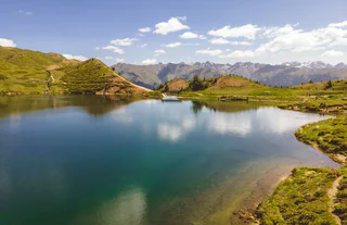
Vinschgau vás okouzlí svou krásou a širokými možnostmi pro zimní sporty a rekreaci. |
Before setting off on this tour, it is legitimate to think about the delicious Kaiserschmarren at the Rescher Alm. Follow the cycle path along the lakeshore from Reschen towards the Schöneben valley station. From the valley station, cycle uphill on the main road, in the direction of Rojen and then in the direction of St. Valentin to the hamlet of Spin. Shortly after the Spin´s farm, take a sharp right onto the forest and meadow path. In the forest, bend the way north above lake Resia and the Rojen road past a small forest lake (1,850 m). Follow the forest road, meet the Rojen road a little later and follow it to the trendy Rescher Alm hut. Here, at an altitude of 2,000 m, with a splendid view from the terrace, enjoy one of the best lunches. From the Rescher Alm alpine hut, continue north along the forest road, down to Tenders, where the Tendershof farmhouse invites for refreshment. From here, it is not far to the final destination: Reschen. Tip: For enduro enthusiasts: there is the option of rocking down via the 3-Länder Trail in the direction of Nauders to the Mutzkopf. From Mutzkopf, take one of the trails to Nauders.
The Adige Trail can be reached just above the Resia and is named after the river in Italy, which springs right next start. He is also the continuation of the bunker trails and leads down to the village Resia and the lake lago di Resia. It is a lightweight, highly flow trail which makes you want more.
Challenging, shady tour with rewarding views and connection variant to the Haslhof snack bar and the legendary Holy Hansen trail.
Start at Hotel Krone in the quiet small village of Morter, that belongs to the municipality of Laces and turn right after the culture center and the fire station following the asphalt road towards Putzenhof. Keep left to pass by its strawberry fields and apple orchards through the National Park gate until the "Wetterkreuz". Follow the forest road with a constant gradient in the shadow of Monte Tramontana until you arrive at Morterer Leger at 1,705 m. The first part of the road is well prepared with white marble gravel, whereas the second half of the road is mainly covered with grass and moss. Having arrived, you will be rewarded with a beautiful picnic area and a nice view of Orecchia di Lepre (3,257 m). Descent on the forest road or on path 7A and the forest road until the Haslhof snack bar and the Holy Hansen trail (S2) or marble quarry.
Anche questo single trail ha tanto da offrire. Parte sopra Spin e rappresenta un interessante raccordo per San Valentino e per la funivia della malga San Valentino; vi accompagnerà lungo il crinale sempre in direzione sud. L'imbocco si raggiunge alla fine della parte inferiore dello Spin Trail.
From Graun, the wonderful Langtaufers valley opens up to the east. First, follow the asphalt road in the direction of Melag until the fork in Kapron. In Kapron, turn right in the direction of Riegl and then follow the shady forest path to the Kaproner Alm alpine pasture (1,960 m), which is closed. Continue slightly up and down to the Masebner Alm alpine pasture, which is closed as well. Following the path upwards, sometimes a bit steep - arrive at the Maseben mountain hut at 2,267 m. Here the innkeeper of the hut welcomes guests with traditional schnapps and local foods. The 2 km back to the Masebner Alm continue towards the valley and Karlin creek. Once on the forest road, turn right and follow a beautiful forest path along the rushing stream to the Melager Alm alpine pasture. Enjoy the views of the glacier world from the rest areas and then follow the forest path again on the orographic left bank to Riegl. Here go briefly uphill to the main road in Kapron. This road will lead you back to Graun.
Con il Plattweg Trail avete davanti a voi un single trail indimenticabile della regione enduro 3-paesi: vi rapisce nel solitario mondo delle montagne altoatesine, offre profonde vedute del lago di Resia e vi porta allo stesso tempo in direzione nord. Alla Schneider Kreuzung si immette nella parte inferiore dello Spin Trail e poi si può scegliere tra il Grein Trail (ritorno alla malga San Valentino) o il Gorf Trail (proseguendo per Belpiano).
On the Haideralm Trail the trails of the 3-Country region shows there full power and technical level. This trail is the most difficult trail. The trail passes directly under the cable car from the mountain station to the place San Valentio/St. Valentin. With the necessary bike-driving skills and technical knowledge the Haideralm Trail is a real big hit for all Enduro-fans.
Il Gorf Trail inizia sopra Spin al termine della parte inferiore dello Spin Trail e questa tratta di sentiero rappresenta il collegamento verso il basso alla ciclabile lungolago. Da lì sulla pista ciclabile in direzione nord si arriva alla funivia Belpiano e a Resia.
Starting from the Etschbrüücke bridge in Kastelbell, the uphill trail to Marzoner Alm mountain pasture leads first along a very steep, paved mountain road to the hamlet of Freiberg (1,200 m). Above Freiberg, at the Pramanthof farm (6,6 km), the surface changes to a gravel road and the slope becomes less steep.The forest path winds its way to the Freiberger Säge parking lot (1.480 m) and then to the Marzoner Alm mountain pasture
The starting point of this partially newly created trail is the historic Bunker high above the lake lago di Resia. Whoever finds time should definitely take a photo here with the lago di Resia in the background. The Bunker Trail is the main link to the south and brings the biker to the entrance of the Adige River Trails who continues to Resia.
Along this short trail, mountain bikers must conquer an altitude of 210 m over a distance of 1.1 km, and the trail is therefore suitable for both beginners and those making a comeback. Along the way, bikers can enjoy a wonderful view of Annenberg Castle and San Martino in Monte.
The Upper Belpiano Trail is a special trail, it is perfectly adapted in the landscape and has challenging parts for all single trail-lovers. The trail starts at the mountainstation Belpiano and goes trough forests down to the brach-off in direction to the 3-Country-Trail. The character changes only insignificantly in the lower part. Wonderful cross-country skiing and deep views of Lake Resia make the Schöneben Trail an unforgettable experience - an experience that can be repeated over and over again thanks to the Schönebenbahn.
The Spin Trail leads the bikers through the lonely mountain world at the 3-Länder Eck and leads along the slope towards the south. The Reschensee to the left flashes again and again through the woods and suddenly it is clear: here I am right! The Upper Spin Trail leads to the Schneider junction. From here it's either back to the Schöneben Bahn or further south to the Haideralm.