Przejdź do treści

dodano do ulubionych

usunięto z ulubionych

Coś poszło nie tak! Wystąpił problem. Spróbuj ponownie

Twoje konto jest właśnie tworzone

Twoje konto zostało pomyślnie utworzone i jesteś teraz zalogowany

Zalogowałeś się pomyślnie!

Twoje konto zostało pomyślnie utworzone, ale nie mogliśmy zalogować Cię automatycznie

Jesteś wylogowany

Filtr
Wybrane filtry
    Poziom trudności
    Czas trwania
    Odległość w km

    Kuligi i jazda konna w Południowym Tyrolu

    Kuligi z zaprzęgiem konnym i jazda konna to idealny sposób na spokojne doświadczenie zimowego krajobrazu zasypanego głębokim śniegiem. Ciesz się kuligiem w Alpe di Siusi/Seiser Alm, któremu towarzyszą dramatyczne widoki na szczyty Dolomitów Schlern i Rosengarten. Lub zarezerwuj romantyczny kulig w Avelengo/Hafling, gdzie na wczasowiczów czekają słynne konie rasy Haflinger. Lub...

    Wyniki
    Cycling
    Bressanone and Passo delle Erbe
    Al Plan/San Vigilio, Dolomites Region Kronplatz/Plan de Corones

    From San Vigilio, pass through Pieve di Marebbe, follow the scenic road to Sares and San Martino (municipality of San Lorenzo) where, near the gravel quarry, you cross the main road and take the Val Pusteria cycle path, as far as Bistro Lanz in Sciaves. Leave the cycle path, taking the right turn onto the road to Sciaves, pass the old bishopric of Bressanone and arrive to Millan, where four hairpin bends lead you to S. Andrea. Here the tiring ascent begins, through dense conifer woods. Cross over the crossroads with the Funes road and continue as far as Passo delle Erbe. Lastly, return to San Vigilio via Antermoia, San Martin and Longega.

    Poziom trudności: średni
    2358 m wysokość w górę
    100.1 Km odległość
    Mountain bike
    Bike Beats - Fle Trail
    Corvara, Dolomites Region Alta Badia
    Bike Beats Pralongiá is a trail which goes through the meadows downhill from the Pralongiá. It is a medium-easy trail (blue) with a total length of 1120 metres and an altitude difference of 134 metres.
    Poziom trudności: łatwy
    15 m wysokość w górę
    1.9 Km odległość
    Cycling
    Road bike tour to the passo delle Erbe/Würzjoch
    Badia, Dolomites Region Alta Badia
    The route to the Passo delle Erbe offers some of the most stunning scenery in the Dolomites. The green meadows on the northern edge of the Puez-Odle Nature Park and the towering Dolomite peaks accompany cyclists along this tour, which may not be among the most famous in the area, but is certainly one of the most impressive.

    Starting from Alta Badia, the route follows relatively low-traffic roads with spectacular panoramic views and occasional technical challenges. On the way to the Passo delle Erbe, cyclists will encounter several sharp hairpin turns and steep climbs, with gradients reaching up to 16%.

    Poziom trudności: średni
    1077 m wysokość w górę
    35.1 Km odległość
    Cycling
    Plan de Corones tour
    Al Plan/San Vigilio, Dolomites Region Kronplatz/Plan de Corones

    Start in the centre of San Vigilio and take the provincial road to Pieve di Marebbe, pass the Passo Furcia and arrive to Valdaora. In the centre of Valdaora di Mezzo turn left on the tarmacked cycle path. Pass Castel Lamberto to reach Riscone. Continue on the provincial road as far as Santo Stefano and San Lorenzo. Before San Lorenzo, take the underpass and follow the road to San Martin (municipality of San Lorenzo) and Sares. Lastly, return to San Vigilio via Pieve di Marebbe along a beautiful scenic and very quiet road.

    Poziom trudności: średni
    1252 m wysokość w górę
    47.8 Km odległość
    Mountain bike
    208 Sellaronda MTB TOUR clockwise
    Sëlva/Selva, Dolomites Region Val Gardena

    The clockwise Sellaronda MTB TOUR involves relatively few uphill metres to cycle (about 370 m), thanks to the use of lifts that allow the transport of mountain bikes and e-bikes. There are numerous trails that require good riding technique. The total time varies according to riding ability: from a minimum of 5 to a maximum of 9 hours, including lunch break.

    Poziom trudności: trudny
    3750 m wysokość w górę
    62.1 Km odległość
    Mountain bike
    303 Passo Gardena circuit
    Sëlva/Selva, Dolomites Region Val Gardena
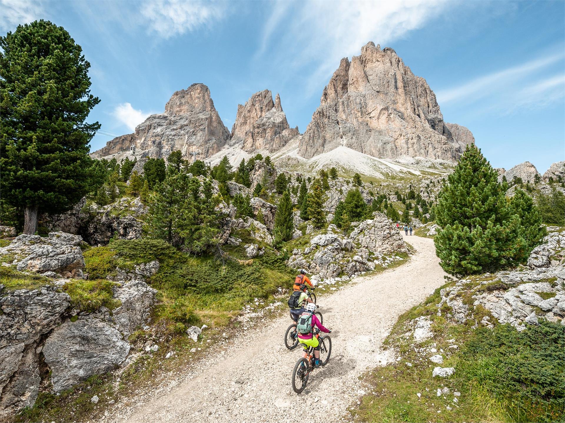
    This Val Gardena MTB loop with its two single trails guarantees a total of over 10 km of trail riding pleasure and pure action. After a relaxed gondola ride in the direction of Dantercëpies, a flow trail begins directly below the breathtaking Cir peaks. Thanks to the Trail Arena ticket, this Cir Tiera Trail, as well as the other trails of the Trail Arena Val Gardena, can be repeated as often as you like. The trail continues along a path that is also open to mountain bikers: from the Gardena Pass it descends below the imposing rock faces of the Sella massif to the Miramonti zone, where the two main roads coming from the Sella Pass and Gardena Pass meet. Continue along a gravel path until you reach the entrance to the last stretch of the Family Trail to Plan de Gralba. If you want, you can take the Piz Seteur cable car and ride this flow trail and the other trails in this area a couple of more times, as they are part of the Trail Arena Val Gardena. Or simply return to Selva via a path that runs to the left of the stream.
    Poziom trudności: średni
    843 m wysokość w górę
    15.3 Km odległość
    Mountain bike
    207 Sellaronda MTB TOUR counterclockwise
    Sëlva/Selva, Dolomites Region Val Gardena

    The counter-clockwise Sellaronda MTB Tour has a total altitude difference of approx. 1,020 m to ride uphill and descents that vary from single trails to gravel roads. It is therefore suitable for uphill cycling with or without pedal assistance/e-bike. The time required varies according to MTB riding ability: from a minimum of 6 to a maximum of 9 hours, including lunch break.

    Poziom trudności: trudny
    3501 m wysokość w górę
    60.3 Km odległość
    E-MTB
    MTB Passo Furcia-Tour
    Al Plan/San Vigilio, Dolomites Region Kronplatz/Plan de Corones

    Partite dal centro di San Vigilio. Seguite la strada per Pieve di Marebbe in salita fino al Passo
    Furcia (bivio subito dopo l’abitato di Corte). Subito dopo l‘Hotel Jú Furcia svoltate a destra e
    seguite la strada nel bosco con il segnavia n. 1 che, passando per Rara e La Miara, vi riporta
    a San Vigilio.

    Poziom trudności: średni
    570 m wysokość w górę
    15 Km odległość
    1