Przejdź do treści

dodano do ulubionych

usunięto z ulubionych

Coś poszło nie tak! Wystąpił problem. Spróbuj ponownie

Twoje konto jest właśnie tworzone

Twoje konto zostało pomyślnie utworzone i jesteś teraz zalogowany

Zalogowałeś się pomyślnie!

Twoje konto zostało pomyślnie utworzone, ale nie mogliśmy zalogować Cię automatycznie

Jesteś wylogowany

Filtr
Wybrane filtry
    Poziom trudności
    Czas trwania
    Odległość w km

    Bieganie w Vinschgau

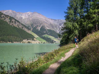
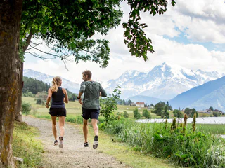
    Pod górę, w dół, po płaskim, po asfalcie, przez lasy, łąki czy po kamieniach i korzeniach – także podczas urlopu możesz kontynuować swój trening biegowy i czerpać z niego jeszcze więcej radości. Czeka tu na Ciebie wiele dobrze oznakowanych i zadbanych tras biegowych, krystalicznie czyste powietrze i wyjątkowe widoki na okoliczny krajobraz.

    Wyniki
    Running & Fitness
    Lotter Trail
    Prad am Stilfser Joch/Prato allo Stelvio, Vinschgau/Val Venosta

    A classic among the trails in Prad. This track offers some technical sections and a wonderful view of the town and the upper Venosta valley.

    Poziom trudności: średni
    451 m wysokość w górę
    2h:27 min czas trwania
    Running & Fitness
    Path along the water channel at Morter
    Latsch/Laces, Vinschgau/Val Venosta

    A scenic and beautiful running route in Morter which leaves nothing to be desired. Flat passages changes with moderate increases, to sensational sleep tracks along the "Neuwaal" and the "Rautwaal".


    Poziom trudności: średni
    0 m wysokość w górę
    0h:40 min czas trwania
    Running & Fitness
    Easy Stelvio Trail
    Stilfs/Stelvio, Vinschgau/Val Venosta

    This exciting tour leads to spectacular and high alpine trails on the left and right side of the legendary Stelvio Pass Road to the homonymous pass peak.

    Poziom trudności: średni
    807 m wysokość w górę
    3h:43 min czas trwania
    Running & Fitness
    Panoramatrail
    Graun im Vinschgau/Curon Venosta, Vinschgau/Val Venosta
    A wonderful training route on the south side of the Langtauferer Valley. Due to the orientation, this route, despite its altitude, is often runnable early in the year. From the starting point in Graun, the first kilometer leads somewhat steeper uphill. Soon, however, it becomes flatter, and you follow the trails and forest roads further into the valley. Most of the time, you head towards Melag on a comfortably runnable incline. Short sections also go downhill now and then, inviting you to catch your breath. Further into the valley, a fantastic view of the Weißkugel glaciers opens up. You can then conveniently return to Lake Reschen by bus.
    Poziom trudności: średni
    918 m wysokość w górę
    4h:19 min czas trwania
    Running & Fitness
    From Laces to San Martino in Monte
    Latsch/Laces, Vinschgau/Val Venosta

    Deny the same stage like the runners of the oldest still taking place mountain run San Martino in Monte which yearly in October takes place.

    The mountain run to San Martino is a real classic, with regular competitions since 1950, also one of the oldest ones of the whole nightmare space. The wonderful distance, the demanding increase, the perfect one infrastructures - a lot speaks for this mountain run.
    The competition distance starts directly on the main square of pasting and leads up to the top terminal of the cable railway. On narrow mountaineering and most different subsoil you procees in your tempo to the wonderful mountain hamlet of San Martino in Monte.

    Poziom trudności: trudny
    1128 m wysokość w górę
    3h:23 min czas trwania
    Running & Fitness
    Nitt Trail
    Prad am Stilfser Joch/Prato allo Stelvio, Vinschgau/Val Venosta

    The little brother of the Lotter Trail. A great warm-up loop for getting to know the area by run.

    Poziom trudności: łatwy
    265 m wysokość w górę
    1h:52 min czas trwania
    Running & Fitness
    VertikalK Up
    Stilfs/Stelvio, Vinschgau/Val Venosta
    Crunchyverticalmountainrunfromthecentretothe hut Gampenhütte.
    Poziom trudności: średni
    1084 m wysokość w górę
    3h:16 min czas trwania
    Running & Fitness
    Stilfserjoch Stelvio Mountain Run
    Prad am Stilfser Joch/Prato allo Stelvio, Vinschgau/Val Venosta

    Signposted mountain run of 21.1 km and 2,100 m altitude difference, that takes ambitious athletes from Prad to the Passo Stelvio summit.

        Mountainrunthat bringstheambitiousathletefromPradover21. 1kmand2.100 hmtotheStelvioPass.
    Poziom trudności: trudny
    2202 m wysokość w górę
    8h:07 min czas trwania
    Running & Fitness
    Easy Panorama Trail
    Stilfs/Stelvio, Vinschgau/Val Venosta

    A short itinerary to acclimatise and discover the mountain village of Sulden, situated at 1,900 m above sea level.

    Poziom trudności: łatwy
    194 m wysokość w górę
    1h:30 min czas trwania
    Running & Fitness
    Tschengls Run
    Prad am Stilfser Joch/Prato allo Stelvio, Vinschgau/Val Venosta

    A panoramic and not too difficult route between the villages of Prad and Tschengls.

    Poziom trudności: łatwy
    181 m wysokość w górę
    2h:08 min czas trwania
    Running & Fitness
    Pineta Run
    Prad am Stilfser Joch/Prato allo Stelvio, Vinschgau/Val Venosta

    Short and pleasant loop between Prad and the Prader fishing ponds.

    Poziom trudności: łatwy
    32 m wysokość w górę
    1h:31 min czas trwania
    Running & Fitness
    Ortles Trail
    Stilfs/Stelvio, Vinschgau/Val Venosta

    Breathtaking running track underneath the famous rocks and glaciers of the Ortles Alps.

    Poziom trudności: średni
    674 m wysokość w górę
    3h:52 min czas trwania
    Running & Fitness
    Panorama Trail
    Stilfs/Stelvio, Vinschgau/Val Venosta

    A short but promising warm-up loop around the climatic health resort of Sulden am Ortler.

    Poziom trudności: łatwy
    364 m wysokość w górę
    2h:16 min czas trwania
    Running & Fitness
    Elevation Trail Nauders
    Graun im Vinschgau/Curon Venosta, Vinschgau/Val Venosta
    A top-class trail run! After a longer ascent, the high-altitude trail runs permanently along the forest border to Italy and Lake Reschen. From the starting point Parditsch in Nauders, you follow the trail to the inn of the same name and continue to the Labaunalm. Now you branch off to the south and follow the trail to the Labauner Köpfl. The long ascent is now overcome, and you can really enjoy the trails with a great view of Lake Reschen and the surrounding mountains. At the Piengalm, after about 14 km, you can stock up on food and drinks before the high-altitude trail climbs slightly again towards Bergkastel. Now you have almost completed all the altitude meters and continue across the border to Italy to the Plamort rock. The downhill is rewarded with a fantastic view of Lake Reschen. Soon the forest road is reached, along which you run the last kilometer to Reschen.
    Poziom trudności: trudny
    1344 m wysokość w górę
    7h:37 min czas trwania
    Running & Fitness
    Trailrunning from Prato to Solda
    Stilfs/Stelvio, Vinschgau/Val Venosta
    From the bottom of the valley in Prad up towards the glacier to Sulden. The route already belongs to the classic sections of the Transalpine Run.
    Poziom trudności: średni
    2829 m wysokość w górę
    8h:00 min czas trwania
    Running & Fitness
    Patzleid Trail
    Prad am Stilfser Joch/Prato allo Stelvio, Vinschgau/Val Venosta

    A short but challenging route to discover the trails around the hamlet of Agums.


    Poziom trudności: łatwy
    384 m wysokość w górę
    2h:40 min czas trwania
    Running & Fitness
    Rosim Trail
    Stilfs/Stelvio, Vinschgau/Val Venosta

    Panoramic and partly very quiet trail to the Rosimböden and the Zay valley.

    Poziom trudności: średni
    633 m wysokość w górę
    3h:15 min czas trwania
    Running & Fitness
    Trailrunning glacier path Solda
    Stilfs/Stelvio, Vinschgau/Val Venosta
    Trail running in a class of its own under the highest mountain in South Tyrol. Very close to the glacier with fantastic views.
    Poziom trudności: trudny
    1552 m wysokość w górę
    7h:02 min czas trwania
    Running & Fitness
    Mareinwaal Loop
    Latsch/Laces, Vinschgau/Val Venosta

    Medium-long, moderately difficult round between forest and apple orchards, between valley and Nörderberg, between ascents and flat passages.

    Poziom trudności: średni
    309 m wysokość w górę
    2h:13 min czas trwania
    Running & Fitness
    Stelvio Trail
    Stilfs/Stelvio, Vinschgau/Val Venosta

    Very demanding but extremely rewarding trail to the peak of the Stelvio Pass.

    Poziom trudności: trudny
    1540 m wysokość w górę
    7h:25 min czas trwania
    Running & Fitness
    Around the lake Resia
    Graun im Vinschgau/Curon Venosta, Vinschgau/Val Venosta

    The round of the Reschensee is a special experience for hikers and runners. The wonderful views of the Ortler is unique. The tower in the lake completes the picture. He is the last witness of the sunken village of Graun which can live the story.

    Poziom trudności: średni
    0 m wysokość w górę
    1h:45 min czas trwania
    Running & Fitness
    Medieval Run
    Prad am Stilfser Joch/Prato allo Stelvio, Vinschgau/Val Venosta

    This sporting excursion leads us back into the Medieval Ages and into the past times of the Venosta Valley.

    Poziom trudności: średni
    122 m wysokość w górę
    4h:35 min czas trwania
    Running & Fitness
    Somataira Trail
    Stilfs/Stelvio, Vinschgau/Val Venosta

    Short but very interesting itinerary in and around the picturesque and very steep alpine village of Stilfs.

    Poziom trudności: łatwy
    278 m wysokość w górę
    1h:26 min czas trwania
    Running & Fitness
    7Springs Trail
    Stilfs/Stelvio, Vinschgau/Val Venosta

    A wonderful tour on the so-called Ochsenberg mountain past the 7 wells and the traditional mountain hut Obere Stilfser Alm.

    Poziom trudności: średni
    968 m wysokość w górę
    4h:24 min czas trwania
    Running & Fitness
    3-Country Elevation Path
    Graun im Vinschgau/Curon Venosta, Vinschgau/Val Venosta
    A long, challenging run that impresses with a fantastic natural experience and a magnificent view of Lake Reschen and the Ortler Group. The starting point is at the Mutzkopf lift valley station, and the run first leads to the Großmutzkopf and then to the Dreiländer Border Stone, where Austria, Italy, and Switzerland meet. The trail continues along the ridge to Rescher Alm, where you can refuel for the first time. Via flowy trails, you reach Schöneben, where more than half of the run is already completed. Over the gorgeous last part of the ridge trail, with constant views of Lake Reschen, the Ortler Group, and the Weißkugel, you finally reach Haideralm. From there, it's all downhill to St. Valentin.
    Poziom trudności: średni
    2424 m wysokość w górę
    6h:00 min czas trwania
    Running & Fitness
    Montoni Trail
    Prad am Stilfser Joch/Prato allo Stelvio, Vinschgau/Val Venosta

    This varied trail and mountain run circles the Montoni, the distinctive local mountain of the hamlet of Agums in Prad.

    Poziom trudności: średni
    1072 m wysokość w górę
    4h:42 min czas trwania
    Running & Fitness
    Piz Lad Trail
    Graun im Vinschgau/Curon Venosta, Vinschgau/Val Venosta
    A route that has it all: a steep climb, flowing trails with some peaks, great downhills, and always a breathtaking view of Lake Reschen and the Ortler Group! From the Reschen Alm, it's first up to the Outer Nockenkopf. Then you follow the partly unmarked but easy and logical mountain ridge up to Piz Lad. This section definitely gets the trail running heart pumping. Fun trails and a unique view now lead back to the starting point at the Reschen Alm.
    Poziom trudności: trudny
    1146 m wysokość w górę
    5h:19 min czas trwania
    Running & Fitness
    Around the lake San Valentino
    Graun im Vinschgau/Curon Venosta, Vinschgau/Val Venosta

    The lake Haidersee is a natural lake with a biotope areas, lead two boardwalks over which. Signs along the way describe the different bird and fish species in the region.

    Poziom trudności: łatwy
    0 m wysokość w górę
    0h:30 min czas trwania
    1 2