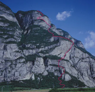
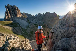
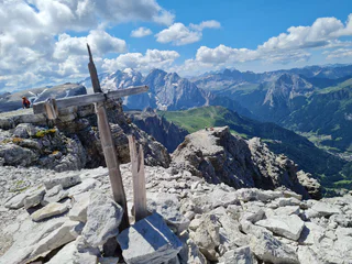
Short, very varied and completely secured with a view of Val di Fassa.
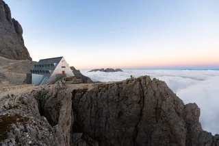
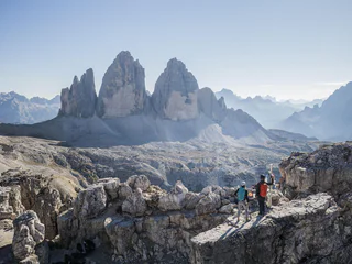
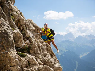
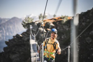
In the Dolomites UNESCO World Heritage Site you must aim high! Make sure you’re always attached to a climbing rope and properly secure your gear. Vie ferrate have different levels of difficulty and thus allow you to reach lofty peaks that would otherwise be inaccessible.
Short, very varied and completely secured with a view of Val di Fassa.
"DOLOMITES WITHOUT BORDERS" - The project was born out of the idea that the Dolomites should no longer be a barrier but a place of meeting and friendship. A high-altitude trekking route including 12 „via ferrata“ - each of them unique from alpine or historical points of view. They are interlinking Italy with Austria. The project extends over the areas of the Cadore and the Hochpustertal, area of the Drei Zinnen all the way to the Tiroler Gailtal. "DOLOMITES WITHOUT BORDERS" runs partly along ancient warpaths, trenches and galleries, a "peace path" on former war sites. An Alpine experience for all mountain enthusiasts!
From the festival place the via Molino up, to the forest road. The wood sign “Gummererhof” points us the direction. Starting from the “Gummerhof” moving way nr. 10 to the steep “Weiße Rissen” and the “Kleinen Göller” (water place), left up to the marking T from Termeno, leads into our moving way. Through seal coniferous forest, way nr. 523, further, past at the hunter hut, up to the waterfall, then 20 min. laborious rise to the “Rifugio Oltradige – Überetscher Hütte” (mountain inn).
To reach the peak of Roen from the „Überetscher Hütte“ there exist two variants:
1) for those who are ambitious and doesn’t suffer from vertigo: via ferrata (marking 523), to the peak of Roen (2116m above sea level), then down through meadows (marking 500) to the mountain pasture of Roen, and again to the „Überetscher Hütte“.
2) The marking 10/560 in the northward direction until the mountain pasture of Roen and over the trail (marking 500) to the Roen. The way back to the Passo della Mendola or descend through the „Tauris“ (marking 10A) direct to Tramin.
"DOLOMITES WITHOUT BORDERS" - The project was born out of the idea that the Dolomites should no longer be a barrier but a place of meeting and friendship. A high-altitude trekking route including 12 „via ferrata“ - each of them unique from alpine or historical points of view. They are interlinking Italy with Austria. The project extends over the areas of the Cadore and the Hochpustertal, area of the Drei Zinnen all the way to the Tiroler Gailtal. "DOLOMITES WITHOUT BORDERS" runs partly along ancient warpaths, trenches and galleries, a "peace path" on former war sites. An Alpine experience for all mountain enthusiasts!
The Vallon Via Ferrata is ideal for those approaching the world of via ferratas with a solid background in high-altitude hiking. The route unfolds in a spectacular alpine setting and is mostly technically easy. Only in the final section, after the characteristic suspension bridge, are there a few more challenging passages with moderate exposure.
From the summit, a breathtaking view opens up over the Sella Group and its inner valleys, offering a truly unforgettable panorama. The equipment along the route is in excellent condition: in 2024, the entire ferrata was completely renovated, now ensuring safety and comfort for all who choose to climb it.
"DOLOMITES WITHOUT BORDERS" - The project was born out of the idea that the Dolomites should no longer be a barrier but a place of meeting and friendship. A high-altitude trekking route including 12 „via ferrata“ - each of them unique from alpine or historical points of view. They are interlinking Italy with Austria. The project extends over the areas of the Cadore and the Hochpustertal, area of the Drei Zinnen all the way to the Tiroler Gailtal. "DOLOMITES WITHOUT BORDERS" runs partly along ancient warpaths, trenches and galleries, a "peace path" on former war sites. An Alpine experience for all mountain enthusiasts!
Meadows of the Croda Rossa – Costoni Croda Rossa - Croda Rossa Peak– Castelliere – Meadows of the Croda Rossa Description: an easy via ferrata with a few exposed places, all the path is good secured. The most part of the via ferrata is to hike and you have wonderful views. You can combine this via ferrata with the Strada degli Alpini (nr. 3) and/or the Ferrata Zandonella (nr. 2). Indications: red-white-red with the nr. 100, via ferrata red triangles, return to the Castelliere with nr. 15B Highlights: panorama from the Croda Rossa peak to the peak of the Tre Scarperi, Croda dei Toni, Cima Undici, Monte Popera Starting point: Meadows of the Croda Rossa (1914m). Duration: total 5 ¾ hours, ascent 3 ½ hours, descent 2 ¼ hours Diffrence of altitude: ca. 1000m
Only walkable if the current weather conditions are good. WARNING: The GPX data may differ from reality. For information your contact is the Alpinschule Sexten Drei Zinnen +39 0474 710375 info@alpinschule-dreizinnen.com
Before departure: check the equipment, the weather conditions and the accessibility
Long but panoramic Alpine tour featuring an easy via ferrata between the Latemar towers.
The Mesules is legendary: it is one of the oldest via ferratas in the Dolomites (1912) as well
as one of the most demanding in the area.
Rifugio Lunelli or Passo Monte Croce – Rifugio Berti – Ferrata Zandonella – Croda Rossa peak– Castelliere – Passo Monte Croce or Rifugio Lunelli Description: the first 200 meters of the ferrata with two ladders and fixed rope is very strenuous and exposed. Descent by some exposed passages to the east part is easier. Fantastic rock scenery! The via ferrata is not in good conditions, especially the steel part. Also the distance from one hook to the next hook is too much and there is also danger of falling rocks! Variant: Access trough the Croda Rossa meadows- ¾ way to the Croda Rossa peak- transverse band- “Sentinellascharte”, ca. 200m in descent, on the left is the entrance- ca. 500m saved altitude. Indications: red-white-red with the nr. 101, via ferrata red-green triangles Highlights: the fantastic rock scenery of the Vallon Popera, the steep passages of the ferrata and the panorama from the top. Starting point: Rifugio Lunelli (1568m) – from the Passo Monte Croce towards Padola, before Padola turn right in the Valgrande until the parking place at the rifugio Lunelli. Duration: total 7 ¾ hours, ascent 4 ¾ hours, descent 3 hours Diffrence in altitude: ca. 1400m
Only walkable if the current weather conditions are good. WARNING: The GPX data may differ from reality. For information your contact is the Alpinschule Sexten Drei Zinnen +39 0474 710375 info@alpinschule-dreizinnen.com
Before departure: check the equipment, the weather conditions and the accessibility
Highly recommendable fixed-cable climbing path for experienced via ferrata climbers Starting point: Locatelli/Drei Zinnen Hut
This via ferrata is only suitable for experienced via ferrata climbers who are sure-footed, have a good head for heights and a lot of stamina.
From the Drei Zinnen hut the trail takes towards the “Frankfurter" rock and then enters into the tunnel. At the end of the tunnel the fixed-cable trail takes to the Gamsscharte passage. From there, it goes steeply up to the summit. In the scree around the summit, you have to concentrate on your climbing – there are various places where you could get confused and go wrong. From the summit, returns to the Gamsscharte passage and from there it goes down a few metres in a rocky gully and further on at the wartime trail to the Forgella Paterno/Paternsattel.
The impressive tunnel passages, numerous openings in the rock and an interesting section where you have to crawl, just before the Paternsattel, make this via ferrata extremely exciting and highly recommended, both for its central location in the Sexten Dolomites and for its summit panoramas.
Only walkable if the current weather conditions are good. WARNING: The GPX data may differ from reality. For information your contact is the Alpinschule Sexten Drei Zinnen +39 0474 710375 info@alpinschule-dreizinnen.com
Before departure: check the equipment, the weather conditions and the accessibility
"DOLOMITES WITHOUT BORDERS" - The project was born out of the idea that the Dolomites should no longer be a barrier but a place of meeting and friendship. A high-altitude trekking route including 12 „via ferrata“ - each of them unique from alpine or historical points of view. They are interlinking Italy with Austria. The project extends over the areas of the Cadore and the Hochpustertal, area of the Drei Zinnen all the way to the Tiroler Gailtal. "DOLOMITES WITHOUT BORDERS" runs partly along ancient warpaths, trenches and galleries, a "peace path" on former war sites. An Alpine experience for all mountain enthusiasts!
The via ferrata Tabaretta is one of the most difficult and impressive in Europe. The via ferrata has many steep passages and not so many resting places. The mountain scenery and the perfect view of the Ortler north face is priceless, which is why this tour is a must.
The first moments of the morning at the top of a peak, when the shy rays of the sun illuminate the surrounding rocks, making them glow a warm orange-gold colour: breathtaking moments that will remain engraved in your heart forever.
Just outside Colfosco, on the bends of the Gardena pass, you can enjoy the inimitable spectacle of the Dolomite sunrise as you climb the peaks of the Cir group. Of all the possible climbs, that to the summit of the Gran Cir is the least difficult.
Short, not particulary difficult climbing path with long rising and falling section in an isolated area. Good orientation skills required. From the car park directly at the lake along the road to the “Riedlhof”, then on the path no. 20 to “Alpe di Pra della Vacca/Kühwiesenhütte” and continue on the path no. 61 and the climbing path until the peak of “Cima dei Colli Alti/Hochalpenkopf”. Walking time: 6 hours Challenge: ** (moderate difficulty)
The Piccolo Cir is a relatively short via ferrata, but not to be underestimated, and is suitable as
a half-day tour.
"DOLOMITES WITHOUT BORDERS" - The project was born out of the idea that the Dolomites should no longer be a barrier but a place of meeting and friendship. A high-altitude trekking route including 12 „via ferrata“ - each of them unique from alpine or historical points of view. They are interlinking Italy with Austria. The project extends over the areas of the Cadore and the Hochpustertal, area of the Drei Zinnen all the way to the Tiroler Gailtal. "DOLOMITES WITHOUT BORDERS" runs partly along ancient warpaths, trenches and galleries, a "peace path" on former war sites. An Alpine experience for all mountain enthusiasts!
From the passo Monte Croce 1.636m
450 m – 1,5 hrs
From the passo, take path no. 124 southwards until you reach Forcella Plan della Biscia (1,942 m) next to Cima Colesei. From there you continue along the old and wide road from the war. A few hundred meters after a prominent curve, you will find a sign and a small stone man. From there you turn left (2.010m) to arrive to the attack of the via ferrata. This climb is not yet well trodden on, but is marked with red dots. It is advisable to wear a helmet in advance, as in the last section you are just below the via ferrata and therefore exposed to a greater risk of falling rocks.
From the Lunelli hut 1.568m
510 m – 1,5 hrs
From the hut you climb up to the Forcella Plan della Biscia (1,942 m) via path no. 171 or alternatively via the wide path no. 155. From there you continue along the old and wide road from the war. A few hundred meters after a prominent curve, you will find a sign and a small stone man. From there you turn left (2.010m) to arrive to the attack of the via ferrata. This climb is not yet well trodden on, but is marked with red dots. It is advisable to wear a helmet in advance, as in the last section you are just below the via ferrata and therefore exposed to a greater risk of falling rocks.
Route description2,5 hrs – level C/D
The entrance is located in a small rubble chute in which the steel cable begins. The path starts off in the same demanding way (D) and then follows a steep rock pillar (C/D) with quite homogeneous difficulty.
After the first difficult third, it continues in easier terrain (A/B) until you reach the ridge of the Arzalpenturm after a traverse (C) and a steep step (C/D).
Crossing the ridge, one reaches a small saddle next to the actual summit of the Campanile Colesei. Here, there is a one-way regulation. The actual summit of the tower can only be reached with an additional variant. One climbs down from the saddle along the steel cable south (C). Soon one reaches a junction with the variant. If you like, you can climb the Campanile Colesei (C/D) and get back to this point in one round. From the junction, follow the path downwards to a saddle (C) from where the steel cable on the opposite side climbs up to the plateau of the Croda Sora I Colesei (C).
The outstandingly beautiful Via Ferrata Santner is secured with steel ropes, iron hooks and ladders, it leads you through small gullies and narrow passes, the most challenging of which is the “Ice Gully”, a small gully which is often covered in hard-packed snow even in August. Due to risk of landslides, this route should only be climbed uphill and not downhill. After you leave the Ferrata at the Santnerpass mountain hut, the trail goes on to the refuge Gartlhütte Hut through the valley of Vajolettal and the Tschagerjoch back to the Kölnerhütte Hut.
A challenging mountain hike with a stunning view of the surrounding Dolomites. The last part beneath the summit consists of a via ferrata on which belaying with a climbing harness is recommended.
A challenging hike with a stunning view of Villnöss/Funes valley, the Geisler mountains and the surrounding Dolomites. The last part beneath the summit consists of a via ferrata on which belaying with a climbing harness is recommended.
This via ferrata is a classic in the Dolomites and is framed by rugged walls and towers with magnificent views. The via ferrata is relatively short with difficult Alpine passages that require Alpine experience.
Rifugio Auronzo – Rifugio Locatelli – Path of the ladders - Torre di Toblin – return Description: repaired via ferrata with a lot of ladders (17 ladders!) and a wonderful round from the top of the Torre di Toblin. Reachable also from the Val Fiscalina or Val Campo di Dentro. Indications: Access and return red triangles, path nr. 101 and 105 Highlights: the ladders and naturally the view to the Three Peaks (Tre Cime) Starting point: Rif. Auronzo (2320m) Duration: total from the Rif. Auronzo 4 ½ hours, ascent 2 ¾ hours, descent 1 ¾ hours Diffrence of altitude: ca. 300m
Only walkable if the current weather conditions are good. WARNING: The GPX data may differ from reality. For information your contact is the Alpinschule Sexten Drei Zinnen +39 0474 710375 info@alpinschule-dreizinnen.com
Before departure: check the equipment, the weather conditions and the accessibility
The Sass Rigais is the main summit of the Geisler and with its 3025 m an absolute must for anyone who wants to conquer the pale mountains. Sure-footedness, head for heights, experience in the mountains and the use of a climbing harness are required.