1/2
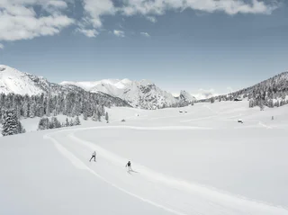
35 Circle at Schmieden/Ferrara
Braies di Fuori/Ausserprags, Prags/Braies, Dolomites Region 3 Zinnen
easy
Obtížnost
32 m
Převýšení
0h:00 min
doba trvání
| Dolomitenregion 3 Zinnen nabízí skvělé možnosti pro běhání. Prozkoumejte krásné trasy, které vedou přírodou. |
1/2
Braies di Fuori/Ausserprags, Prags/Braies, Dolomites Region 3 Zinnen
easy
Obtížnost
32 m
Převýšení
0h:00 min
doba trvání

S. Candido/Innichen, Toblach/Dobbiaco, Dolomites Region 3 Zinnen
easy
Obtížnost
27 m
Převýšení
0h:00 min
doba trvání
Villabassa/Niederdorf, Niederdorf/Villabassa, Dolomites Region 3 Zinnen
easy
Obtížnost
1192 m
Převýšení
0h:00 min
doba trvání
Sesto/Sexten, Sexten/Sesto, Dolomites Region 3 Zinnen
medium
Obtížnost
21 m
Převýšení
0h:00 min
doba trvání
Gandelle-Franadega-Fienili/Kandellen-Frondeigen-Stadlern, Toblach/Dobbiaco, Dolomites Region 3 Zinnen
easy
Obtížnost
10 m
Převýšení
0h:00 min
doba trvání
Braies di Fuori/Ausserprags, Prags/Braies, Dolomites Region 3 Zinnen
difficult
Obtížnost
246 m
Převýšení
0h:00 min
doba trvání
St. Veit/S. Vito - Sexten/Sesto, Sexten/Sesto, Dolomites Region 3 Zinnen
easy
Obtížnost
13 m
Převýšení
0h:00 min
doba trvání
Villabassa/Niederdorf, Niederdorf/Villabassa, Dolomites Region 3 Zinnen
easy
Obtížnost
8121 m
Převýšení
0h:00 min
doba trvání
Braies di Fuori/Ausserprags, Prags/Braies, Dolomites Region 3 Zinnen
easy
Obtížnost
22 m
Převýšení
0h:00 min
doba trvání
Gandelle-Franadega-Fienili/Kandellen-Frondeigen-Stadlern, Toblach/Dobbiaco, Dolomites Region 3 Zinnen
easy
Obtížnost
76 m
Převýšení
0h:00 min
doba trvání
Dobbiaco Vecchia/Alttoblach, Toblach/Dobbiaco, Dolomites Region 3 Zinnen
medium
Obtížnost
398 m
Převýšení
0h:00 min
doba trvání
S. Candido/Innichen, Toblach/Dobbiaco, Dolomites Region 3 Zinnen
easy
Obtížnost
49 m
Převýšení
0h:00 min
doba trvání
1/7
Monguelfo/Welsberg, Prags/Braies, Dolomites Region 3 Zinnen
easy
Obtížnost
69 m
Převýšení
0h:00 min
doba trvání
Gandelle-Franadega-Fienili/Kandellen-Frondeigen-Stadlern, Toblach/Dobbiaco, Dolomites Region 3 Zinnen
difficult
Obtížnost
129 m
Převýšení
0h:00 min
doba trvání
Sesto/Sexten, Sexten/Sesto, Dolomites Region 3 Zinnen
easy
Obtížnost
10 m
Převýšení
0h:00 min
doba trvání
Gandelle-Franadega-Fienili/Kandellen-Frondeigen-Stadlern, Toblach/Dobbiaco, Dolomites Region 3 Zinnen
easy
Obtížnost
20 m
Převýšení
0h:00 min
doba trvání
Dobbiaco Vecchia/Alttoblach, Prags/Braies, Dolomites Region 3 Zinnen
difficult
Obtížnost
574 m
Převýšení
0h:00 min
doba trvání
Gandelle-Franadega-Fienili/Kandellen-Frondeigen-Stadlern, Toblach/Dobbiaco, Dolomites Region 3 Zinnen
easy
Obtížnost
26 m
Převýšení
0h:00 min
doba trvání
Gandelle-Franadega-Fienili/Kandellen-Frondeigen-Stadlern, Toblach/Dobbiaco, Dolomites Region 3 Zinnen
difficult
Obtížnost
95 m
Převýšení
0h:00 min
doba trvání
Alttoblach/Dobbiaco Vecchia, Toblach/Dobbiaco, Dolomites Region 3 Zinnen
medium
Obtížnost
41 m
Převýšení
0h:00 min
doba trvání
Villabassa/Niederdorf, Prags/Braies, Dolomites Region 3 Zinnen
easy
Obtížnost
28 m
Převýšení
0h:00 min
doba trvání
S. Candido/Innichen, Innichen/San Candido, Dolomites Region 3 Zinnen
easy
Obtížnost
47 m
Převýšení
0h:00 min
doba trvání
Sesto/Sexten, Sexten/Sesto, Dolomites Region 3 Zinnen
medium
Obtížnost
40 m
Převýšení
0h:00 min
doba trvání
Braies di Fuori/Ausserprags, Prags/Braies, Dolomites Region 3 Zinnen
medium
Obtížnost
197 m
Převýšení
0h:00 min
doba trvání
Sesto/Sexten, Sexten/Sesto, Dolomites Region 3 Zinnen
medium
Obtížnost
44 m
Převýšení
0h:00 min
doba trvání
Villabassa/Niederdorf, Niederdorf/Villabassa, Dolomites Region 3 Zinnen
medium
Obtížnost
2479 m
Převýšení
0h:00 min
doba trvání
Gandelle-Franadega-Fienili/Kandellen-Frondeigen-Stadlern, Toblach/Dobbiaco, Dolomites Region 3 Zinnen
difficult
Obtížnost
112 m
Převýšení
0h:00 min
doba trvání
Braies di Fuori/Ausserprags, Prags/Braies, Dolomites Region 3 Zinnen
medium
Obtížnost
119 m
Převýšení
0h:00 min
doba trvání
Gandelle-Franadega-Fienili/Kandellen-Frondeigen-Stadlern, Toblach/Dobbiaco, Dolomites Region 3 Zinnen
medium
Obtížnost
132 m
Převýšení
0h:00 min
doba trvání
Villabassa/Niederdorf, Niederdorf/Villabassa, Dolomites Region 3 Zinnen
easy
Obtížnost
3457 m
Převýšení
0h:00 min
doba trvání


