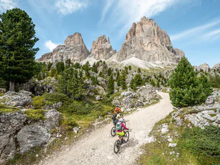
Skip to content

added to favourites

removed from favourites

Oops! Something went wrong. Try again

Your account is being created

Your account has been successfully created and you are now logged in

You’ve been logged in successfully!

Your account was created successfully, but we couldn't log you in automatically

You are logged out.

Filter
Selected filters
    Level of difficulty
    Duration
    Distance in KM

    Cycle routes in the Dolomites

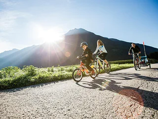
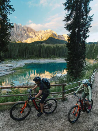
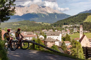
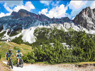
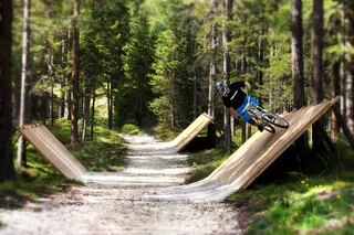
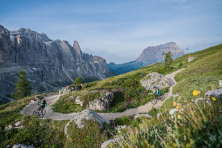
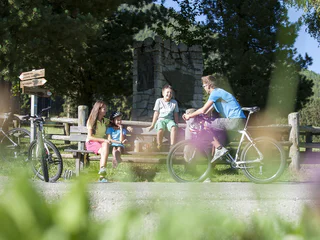
    You can travel long distances on a bike, feel a sense of freedom and warm up for the best adventures. Experience the thrill of discovering new places on two wheels in South Tyrol, where the cycling season starts as early as March. If you are a hardened cyclist, you’ll have your best time cycling on pass roads and on the valley cycle route. You’ll surely find a wealth of family-friendly excursions through South Tyrol’s unique cultural landscape and if you hop on the e-bike, you’ll probably travel even further.

    Results
    E-Bikes
    To the Biotope Rasner Möser
    Rasen-Antholz/Rasun Anterselva, Dolomites Region Kronplatz/Plan de Corones

    The Rasner Möser biotope is located between Oberrasen and Antholz-Niedertal. This easy cycle tour, which is also suitable for children, can therefore be started from either of these two starting points. The highlight of this tour is definitely the biotope roughly halfway along the route. In this nature reserve, there are two small lakes which invite you to relax in the shade of the trees, as well as an educational nature trail with interesting information about this moorland area.

    Difficulty: easy
    192 m elevation gain
    12.3 Km distance
    E-Bikes
    To the view of the Three Peaks
    Toblach/Dobbiaco, Dolomites Region Kronplatz/Plan de Corones

    This challenging tour of approx. 33 km first leads along the cycle path out of the valley, past the football pitch in Niederrasen and under the Pustertal Valley road. The route then continues to Oberolang and from there you join the Pustertal Valley cycle path. Continue cycling past the villages of Welsberg and Niederdorf until you reach Toblach. Turn right there and continue to Lake Toblach. Afterwards continue in the direction of Cortina until you reach the Drei Zinnen viewpoint, which is located directly next to the cycle path. In just another 5 minutes you can reach Lake Dürrensee, with the breathtaking Cristallo mountain group in the background. There are various refreshment stops for a short break along this route. The return journey then follows the same route back to the starting point.

    Difficulty: medium
    562 m elevation gain
    30.8 Km distance
    E-Bikes
    To Sand in Taufers to the starting point of the Waterfalls Reinbach
    Rasen-Antholz/Rasun Anterselva, Dolomites Region Kronplatz/Plan de Corones

    We start this moderately difficult tour in Antholz-Mittertal and first cycle out of the valley to the historic bridge. From there, the route continues to Neunhäusern and from there onto the Pustertal Valley cycle path to Bruneck, where we then turn off into the Tauferer Ahrntal. On the way to our destination, we first cycle through the beautiful villages of St. Georgen, Gais and Uttenheim and the unspoilt nature in between. The trail continues towards Kematen and our destination at the Reinbach waterfalls, which can be explored on foot (approx. 20 minutes to walk to the waterfalls) and are the absolute highlight of this tour.

    Difficulty: medium
    167 m elevation gain
    32.9 Km distance
    E-Bikes
    Redensberg - Aschbach - Nasen
    Rasen-Antholz/Rasun Anterselva, Dolomites Region Kronplatz/Plan de Corones

    This medium-difficulty tour starts in Antholz Niedertal and initially leads out of the valley past the Rasner Möser biotope to Oberrasen. There the route turns off onto the Burgfriedenstraße and the ascent to Burgfrieder Stöckl begins. The route now continues along a forest road to Redensberg and on another section of the forest, which is almost flat, to Aschbach. From there, the route descends again in wide hairpin bends to the village of Nasen. From there, you return to the Val Pusteria cycle path. The route then leads back to Neunhäusern, past the historic bridge, to Niederrasen and along the cycle path back to Antholz Niedertal.

    Difficulty: difficult
    583 m elevation gain
    25.7 Km distance
    E-MTB
    Round trip Rieserferner
    Rasen-Antholz/Rasun Anterselva, Dolomites Region Kronplatz/Plan de Corones

    This challenging tour, which requires a certain level of fitness, starts in Niederrasen and first leads into the valley, past Lake Antholz, up to the Staller Sattel mountain pass (Attention! Temporary one-way regulation with traffic light: from South Tyrol to Austria every hour from the 30th to the 45th minute). The route then descends into the Defereggen Valley and turns left just before Erlsbach. The route then leads; first on tarmac, then on gravel; along the river to the famous hunting lodges. Then it leads up to the Klammljoch Pass and from there downhill again, past the Knuttenalm mountain hut, to Rein in Taufers. From there, the route runs along the paved road to Sand in Taufers and along the cycle path out of the valley to Bruneck. From there, take the Pustertal Valley cycle path back to Niederrasen, turning off at Neunhäusern into the Antholzertal Valley.

    Difficulty: difficult
    2122 m elevation gain
    91.4 Km distance
    E-Bikes
    To the Lake Antholz
    Rasen-Antholz/Rasun Anterselva, Dolomites Region Kronplatz/Plan de Corones

    Starting from Neunhäusern, the Antholzertal Valley cycle path leads you into the valley to Antholz Mittertal. There is a lot to discover along this route, such as the Niederrasen leisure park, the Rasner Mösner biotope in Oberrasen, the MTB area and the fish pond in Antholz Niedertal as well as the sports area and playground in Antholz Mittertal. From Antholz Mittertal, you then switch from the cycle path to the road to cycle the last section up to Lake Antholz. Another highlight just before you reach the lake is the Biathlon Arena, where World Cup races are held every winter.

    Difficulty: medium
    778 m elevation gain
    18.1 Km distance
    Mountain bike
    Fanes Senes MTB Tour: beautiful, smart, invincible
    Al Plan/San Vigilio, Dolomites Region Kronplatz/Plan de Corones

    A heroic ride through the empire of the Ladin legend Dolasila

    She was beautiful, she was brave and she was smart: Dolasila, the Princess of Fanes and a legendary warrior, led her people on the battlefields of what is today the national park Fanes Senes Prags. Her story is packed with magical creatures and glorious victories, with treachery and deceit. Ride through the setting of this Ladin national epic on the Fanes Senes-Tour.


    A Ladin Epic:

    In ancient days the high plains of Fanes were ruled by a ruthless king. His beautiful daughter, however, was just the contrary. In a sign of gratitude for her compassion, the dwarfs at the Silver Lake in Canazei rewarded her with a white armour and unfailing arrows that made her invincible. After her first great battle at the Kronplatz the warrior led the Fanes people in a series of victories. Yet Dolasila was also exposed to treachery and deceit – from her enemies, but also from her own people...


    Difficulty: difficult
    2231 m elevation gain
    55.1 Km distance
    E-Bikes
    To the Pragser Wildsee Lake
    Rasen-Antholz/Rasun Anterselva, Dolomites Region Kronplatz/Plan de Corones

    The medium-difficulty tour to Lake Prags runs mostly on paved cycle paths and wide gravel roads. Between the villages of Welsberg and Niederdorf, the path takes a turn into the Prags Valley. The route extends a few kilometres into the valley until you reach the village of Außerprags. Here the valley splits up in the direction of Plätzwiese or the famous Lake Prags. The ascent to the lake is not too difficult, only the last 3 kilometres are a little steeper and from St. Veit the route runs along the main road. Once there, the breathtaking panorama of the lake makes up for the previous exertions. If you still have some stamina left, you can explore the lake on a flat circular trail by foot.

    Difficulty: medium
    766 m elevation gain
    27.1 Km distance
    E-Bikes
    To Innichen
    Rasen-Antholz/Rasun Anterselva, Dolomites Region Kronplatz/Plan de Corones

    The route initially leads out of the valley, past the football field in Niederrasen and under the Pustertal road. It continues to Oberolang, where you join the Pustertal cycle path. We first cycle past the beautiful Olang reservoir and then pass through the idyllic towns of Welsberg, Niederdorf, and Toblach, until we reach our destination, Innichen, the last major town before the Austrian border. Once there, there are numerous attractions to discover, such as the Acquafun water park, the DoloMythos natural history museum, and the Haunold mountain with its summer toboggan run. Furthermore, the famous Drau cycle path (44 km) leads from Innichen to Lienz in Austria. Innichen also offers a wide selection of bars and restaurants for your culinary needs. For the return journey, you can also take the train from Innichen back to Olang.

    Difficulty: medium
    342 m elevation gain
    25.3 Km distance
    E-Bikes
    To the Kurpark in Niederdorf
    Niederdorf/Villabassa, Dolomites Region Kronplatz/Plan de Corones

    We start this moderately difficult tour at the sports field in Antholz-Niedertal and initially cycle out of the valley on the gravel path. We pass the Rasner-Möser biotope and the route then leads out of the valley, past the football pitch in Niederrasen and under the Puster Valley road. The route continues to Oberolang and then joins the Puster Valley cycle path. Continuing in the direction of Welsberg, the forest path first takes us past the Olang reservoir lake and once we have passed Welsberg, it is not far to Niederdorf. At the end of the village, we reach the Kurpark, where a barbecue area and large playground invite us to linger for a while.

    Difficulty: medium
    423 m elevation gain
    23.4 Km distance
    Downhills
    Furcia Trail
    Bruneck/Brunico, Dolomites Region Kronplatz/Plan de Corones

    The Herrnsteig trail's little brother too is packed with flow and curves. But while it's nowhere near as wild and bumpy, its 124 bends and turns between the top of Mount Kronplatz and Passo Furcia make it at least equally winding and dizzying. To get back up to the top, simply hop on the Ruis cable car at Passo Furcia. The big challenge on this trail is to master it without pedalling and with as little use of the brakes as possible. It is ideal for medium-advanced and pro bikers who wish to get to most out of an active riding style.

    Difficulty: medium
    0 m elevation gain
    4.9 Km distance
    E-MTB
    458 Royal Dolomites Tour
    Kastelruth/Castelrotto, Dolomites Region Seiser Alm

    This mountain-bike or e-bike tour treats bikers to a view of all of the Kings and Queens of the Dolomite mountains, including the Marmolada – Queen of the Dolomites, the majestic Langkofel and Plattkofel, King Laurin and his Rosengarten massif, and the Schlern in all of its legendary might. The route leads from the Eggental Valley to the Fassa Valley and on to the Gröden Valley, followed by a stretch through the Dolomites region Seiser Alm and back to the set-off point. Given its length of approx. 97 km, we recommend taking this tour in a few stages. If you opt to use an e-bike, it is possible to cycle the full length in one day, stopping off at one of the countless mountain huts to recharge your bike along the way. You can choose to begin the tour from any one of the valleys it covers.
    Information about the timetables and tickets of the summer lifts: www.seiseralm.it/cablecars

    Difficulty: difficult
    4014 m elevation gain
    97.2 Km distance
    Downhills
    CC Top Line
    Al Plan/San Vigilio, Dolomites Region Kronplatz/Plan de Corones

    This line is a more technical and “rocky” version of the Furcia trail featuring sections littered with roots, boulders and carved berms. Suitable for experienced riders who are comfortable handling their bike throughout rough terrain.

    Level: medium to difficult

    Difficulty: medium
    0 m elevation gain
    687.0 m distance
    E-Bikes
    Eisacktal Valley Bike Route: Brenner - Bozen
    Mühlbach/Rio di Pusteria, Brixen/Bressanone and environs

    The Brenner Bike Route spans 96 kilometers through the Eisack Valley down to Bolzano. Enjoy gentle hills, charming villages, and cultural treasures along the way. Ideal for those who love to combine nature, culture, and active travel.

    Difficulty: medium
    327 m elevation gain
    103 Km distance
    E-Bikes
    To Bruneck
    Bruneck/Brunico, Dolomites Region Kronplatz/Plan de Corones

    This medium-difficulty tour begins in the Antholz Valley and leads along the Antholz Valley cycle path out of the valley, where you then cycle under the historic bridge, turn right and reach Neunhäusern. We then cycle through Neunhäusern and follow the course of the River Rienz on the Pustertal Valley cycle path to Bruneck. A particular highlight is the breathtaking Rienz gorge just before the town.

    Difficulty: easy
    124 m elevation gain
    11.4 Km distance
    E-Bikes
    To the Malga Vitelli/Kälberalm
    Stilfs/Stelvio, Vinschgau/Val Venosta

    The mountain bike tour to the Malga Vitelli/Kälberalm is an easy tour, which leads through the forest to an alpine pasture. Since the tour follows a forest path, it is suitable for e-bikers.

    Difficulty: easy
    223 m elevation gain
    1.2 Km distance
    Downhills
    Crazy Bunny Line
    Bruneck/Brunico, Dolomites Region Kronplatz/Plan de Corones

    With plenty of jumps, bumps and bends in quick succession, this line is an “up-in-the-air” variant along the Furcia trail. If you’re not afraid to let go of the brakes and take off, you’re in for tons of fun on this trail.

    Level: medium

    Difficulty: medium
    0 m elevation gain
    491.0 m distance
    E-Bikes
    To the Rifugio Forcola/Furkelhütte
    Prad am Stilfser Joch/Prato allo Stelvio, Vinschgau/Val Venosta

    The mountain bike tour to the Rifugio Forcola/Furkelhütte is a wonderful tour to a hut with a breathtaking view and the possibility to stop for refreshments. As the tour runs through a forest path it is very suitable for e-bikers.

    Difficulty: difficult
    1628 m elevation gain
    40.2 Km distance
    E-Bikes
    Pustertal Valley bike route to Mühlbach
    Rasen-Antholz/Rasun Anterselva, Dolomites Region Kronplatz/Plan de Corones

    From Niederrasen, we first cycle along the cycle path out of the valley to the historic bridge. From there, we continue to Neunhäusern,, where we turn off onto the Pustertal cycle path. We then follow it until we reach Bruneck. After leaving the town behind us, we first reach St. Lorenzen. Here you will find the Mansio Sebatum Archaeological Museum, which is dedicated entirely to the Iron Age and especially the Roman period in the region. As the route continues, we pass the villages of Ehrenburg, Kiens, St. Sigmund and Vintl, each of which is always worth a detour in its own right, until we reach our destination in Mühlbach. For your return journey, you also have the possibility to take the train with bike transport back to Olang.

    Difficulty: medium
    202 m elevation gain
    37.3 Km distance
    E-Bikes
    To the Staller Saddle
    Olang/Valdaora, Dolomites Region Kronplatz/Plan de Corones

    The challenging tour to the Staller Sattel ass is one of the classic routes for South Tyrolean cycling enthusiasts. A gravel track leads you from Niederrasen along the river to Antholz Niedertal. The route continues through the village of Antholz Mittertal and along the paved main road to the beautiful Lake Antholz. From there, the final ascent to the 2,052 m high Staller Sattel alpine pass begins, which boasts numerous hairpin bends and breathtaking viewpoints (Important! Temporary one-way traffic regulation with traffic light: from South Tyrol to Austria every hour from the 30th to the 45th minute; from Austria to South Tyrol every hour from the full hour to the 15th minute).

    Difficulty: difficult
    1424 m elevation gain
    22.3 Km distance
    Cycling
    Giro Adventure Tour
    Olang/Valdaora, Dolomites Region Kronplatz/Plan de Corones

    The reminiscence of the Giro d'Italia. Walk in the footsteps of the racing bike stars and Giro legends and cover 769 m of altitude. The (sports) history-laden adventure tour does not yet take you to the Stallersattel, but "only" to the Antholz Lake. That should be enough to warm you up. The ride along the valley cycle path through Olang and the Anthiolz Valley offers a great first overview - but the last climb to the biathlon centre gives you a real Giro feeling. Don't forget your pink jersey!

    Difficulty: medium
    1234 m elevation gain
    44.4 Km distance
    E-Bikes
    Through Hamlet Salla to Welsberg and Taisten
    Rasen-Antholz/Rasun Anterselva, Dolomites Region Kronplatz/Plan de Corones

    This medium-difficulty tour first leads you out of the valley on the cycle path, past the football pitch in Niederrasen and under the Puster Valley road. The route then continues to Oberolang and veers towards the Pustertal Valley cycle path. After the cemetery in Oberolang, turn right, follow the road to the hamlet of Salla and cycle on to Welsberg. Follow the cycle path along the river in the direction of the Gsieser Valley. After approx. 2 km, turn off towards Taisten, cycle through the village and then reach the beautiful hill from where you have a breathtaking view of the Dolomites. Continue along the road until you reach the Obergoste, from where you descend to Rasen. After the Hotel Alte Goste, the cycle path turns right to Rasen (gravel road from here) and you return directly to Niederrasen.

    Difficulty: medium
    1093 m elevation gain
    22.8 Km distance
    E-Bikes
    To St. Jakob in Defereggental (AUT)
    Rasen-Antholz/Rasun Anterselva, Dolomites Region Kronplatz/Plan de Corones

    This challenging route starts in Rasen and first leads into the Antholzertal valley. The cycle path leads to Antholz Mittertal, after which you cycle the last stretch to Lake Antholz on the road. From there, the steep ascent to the Staller Sattel border crossing to Austria begins (Important! Temporary one-way traffic regulation with traffic light: from South Tyrol to Austria every hour from the 30th to the 45th minute; from Austria to South Tyrol every hour from the full hour to the 15th minute). There are huts on both sides of the mountain pass where you can take a short break and enjoy the breathtaking panorama. On the Austrian side, the route then descends again through the Defereggen Valley through the rugged mountain landscape to our destination, the village of St. Jakob.

    Difficulty: difficult
    1656 m elevation gain
    38.0 Km distance
    E-Bikes
    To the Malga Stelvio di Sopra/Oberen Stilfser Alm
    Stilfs/Stelvio, Vinschgau/Val Venosta

    The mountain bike tour leads along a forest path to the Malga Stelvio di Sopra/Oberen Stilfser Alm, which makes it ideal for e-bikers. At the end of this relatively easy tour, a managed alpine hut awaits you, with its own alpine dairy and refreshment facilities.

    Difficulty: easy
    504 m elevation gain
    9.5 Km distance
    E-Bikes
    To Welsberg
    Welsberg-Taisten/Monguelfo-Tesido, Dolomites Region Kronplatz/Plan de Corones

    The route initially leads along the cycle path out of the valley, past the football pitch in Niederrasen and under the Puster Valley road to Oberolang. At this point, we change to the Puster Valley cycle path and then cycle past the impressive Olang reservoir lake before reaching the village of Welsberg in just a few kilometres. Once you are there, you will be able to explore the idyllic village, where numerous restaurants and bars invite you to take a short break before the return journey. Welsberg is also ideal for a short shopping trip and for families with children there is plenty to discover at Prenninger Park.

    Difficulty: medium
    153 m elevation gain
    16.2 Km distance
    E-Bikes
    Around the Kronplatz
    Rasen-Antholz/Rasun Anterselva, Dolomites Region Kronplatz/Plan de Corones

    This circular tour around South Tyrol's number one ski resort, the Kronplatz, can be started from any of the villages surrounding the mountain and can be ridden in both directions, clockwise and counterclockwise. It takes the ardent cyclist past many idyllic villages and through the beautiful nature of the Puster and Gader Valley. A special highlight is the ascent to the 1,789 m high Furkel Pass, which offers an incomparable panorama of the valley below. Along the route, there are numerous opportunities to take a break and indulge in local delicacies in an alpine hut or at a bar or restaurant in the villages.

    Difficulty: difficult
    1309 m elevation gain
    47.9 Km distance
    Cycling
    Maratona dles Dolomites - Maratona course
    Sëlva/Selva, Dolomites Region Alta Badia
    The Maratona route of the Maratona dles Dolomites is 138 km long with a total elevation gain of 4,230 meters. Cyclists tackle iconic climbs like Passo Campolongo (1,875 m), Passo Pordoi (2,239 m), Passo Sella (2,244 m), Passo Gardena (2,121 m), and the challenging Passo Giau (2,236 m) with slopes reaching up to 15%. After Passo Valparola (2,200 m), riders face the steep Mür dl Giat (1,472 m), a short but tough stretch that tests even experienced cyclists.
    Difficulty: difficult
    5121 m elevation gain
    137.9 Km distance
    Cycling
    Roda de Fodom road bike tour
    Badia, Dolomites Region Alta Badia

    The Dolomites Bike Day Route is a panoramic circuit of about 50 km that takes the cyclists on some of the epic stages of the "Giro d'Italia" and the Maratona dles Dolomites roadbike marathon. You will cyclie on legendary mountain passes in the heart of the Dolomites UNESCO World Heritage.

    There are several routes that extend between South Tyrol and Veneto and that every cyclist can choose independently depending on ability and condition.

    Once a year, usually in mid-June, the Campolongo, Falzarego and Valparola passes are closed to motorized traffic from 9 am to 3 pm. On this special day the roads connecting the Ladin valleys Val Badia, Livinallongo and Ampezzo are reserved exclusively for cyclists.

    Difficulty: medium
    1399 m elevation gain
    53.8 Km distance
    Mountain bike
    MTB Plan de Corones-Tour
    Al Plan/San Vigilio, Dolomites Region Kronplatz/Plan de Corones


    Demanding and varied circular tour on San Vigilio local mountain. Includes some the most peaceful routes to one of the most highly developed mountains in the region. Tip: You should not forget to include a visit to the MMM Corones (Messner Mountain Museum)!


    Difficulty: difficult
    1143 m elevation gain
    25.5 Km distance
    Cycling
    Bressanone and Passo delle Erbe
    Al Plan/San Vigilio, Dolomites Region Kronplatz/Plan de Corones

    From San Vigilio, pass through Pieve di Marebbe, follow the scenic road to Sares and San Martino (municipality of San Lorenzo) where, near the gravel quarry, you cross the main road and take the Val Pusteria cycle path, as far as Bistro Lanz in Sciaves. Leave the cycle path, taking the right turn onto the road to Sciaves, pass the old bishopric of Bressanone and arrive to Millan, where four hairpin bends lead you to S. Andrea. Here the tiring ascent begins, through dense conifer woods. Cross over the crossroads with the Funes road and continue as far as Passo delle Erbe. Lastly, return to San Vigilio via Antermoia, San Martin and Longega.

    Difficulty: medium
    2358 m elevation gain
    100.1 Km distance
    1 2 3 4 5 6 7 8 9 10 11 12 13 14 15 16 17 18 19 20 21