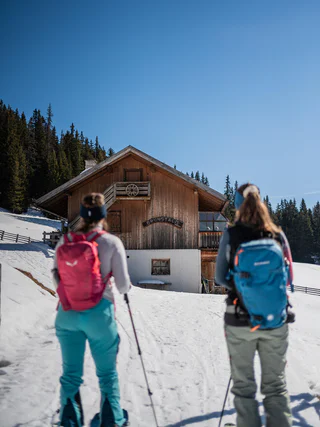
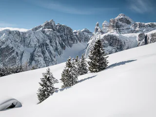
The skitour to the "Kleinen Jaufen" is a varied tour in the middle of the Dolomites.
Attention: Please check the avalanche bulletin updated every day!
If you ski uphill, you'll find meters of soft snow and lookout points that can only be seen from above. Leave your trace in the snow and reach the highest points to go down full of joy. Are you ready to put your skis on and exprience alpine skiing in the Dolomites? Come to South Tyrol and find the level of difficulty that fits your skiing skills.
The skitour to the "Kleinen Jaufen" is a varied tour in the middle of the Dolomites.
Attention: Please check the avalanche bulletin updated every day!
We love the Three Peaks. And we love ski tours through the snowy mountain world of the Sesto Dolomites. We combine both of these on the ski tour to the Sextner Stein/ Sasso di Sesto, true summit bliss is also guaranteed here, with a fantastic view of the pale giants rising to the sky in the sea of snow.
IMPORTANT: Before starting any ski tour/snowshoe excursion, you must check the weather conditions and danger avalanches report, asking also experts (alpine guides etc.). WARNING: The GPX data may differ from reality.
The Fundres/Pfunders massif offers a wide range of hiking options with anything from soft-rolling hills to steep slopes leading up to craggy peaks. Gorgeous excursions for both summer-time hikers and winter sports fans – all topped off by breath-taking 360° panoramic views.
An easy ski mountaineering tour on a groomed path, initially along a nice trail through the woods which then leads to a wonderful panoramic point: a stop is a must here to admire the charm of nature covered in a beautiful white mantle. Once you have reached your destination, from the refuge located at the foot of the splendid Pralongiá plateau, you can admire the Sassongher and the Sella Group.
The classic Gsieser ski and snowshoe hike through the Pfoital and to the Hochkreuzspitze
Starting point: Val Casies/Gsiesertal Valley – S. Maddalena, Head of the valley 1465 m
Hiking time: 4 ½ hours
Level of difficulty: moderate – difficult; for average skiers, the route offers a wide and open terrain with only a few steep slopes that only require extra caution following fresh snow
Altitude difference: 1274 m
Slope exposure: southwest
A ski mountaineering excursion on an easy and fascinating route, ideal for those approaching off-piste skiing for the first time. Passo Valparola, situated in a spectacular position with a splendid view of Lagazuoi, Sass de Stria, Setsas, Lavarela and Conturines, can be reached by car, bus or taxi (minibuses for 8-9 people) from Armentarola.
The ski tour through the Mezdí Valley is one of the classics among the off-piste itineraries in the Dolomites. The tour runs from south to north and is characterized by a short crossing of the Sella massif with only little difference in height, and by a steep and technical descent to Colfosco, through this narrow valley in the middle of the rocks.
Caution:
From Unterplanken across to the Schuher Alm, and from the Golfen all the way to the Hochhorn
Starting point & parking: Unterplanken in Pichl in the Gsiesertal Valley 1213 m
Descent: back via the ascent route
Hiking time: ca. 5 hours
Level of difficulty: moderate – difficult; for average skiers, open terrain with moderate slope gradient, minor technical difficulties
Altitude difference: 1400 m
Slope exposure: southwest
Best period: December till March
Anyone who is staying in Valdaora can start these moderately difficult ski tours to the Piz da Peres or the Dreifingerspitze at the Passo di Furcia-Furkelpass and then first of all leave their tracks through the dense forests. Higher up, well-marked trails lead over at times very steep scree cirques and broad meadow slopes approximately 750 meters (2,500 feet) higher to the corresponding destination.
Route: Right behind the Gasthof Bad Bergfall you go on on the on forestall way (path n. 32) for a little while over two hairpins (direction West), then the path turns toward Sud, in Langtal. From here you easily reach a bridge that leads right over a stream. Now you can either go on on the left side of the stream, or once crossed the bridge turn left so that you will find yourself on the right side of the stream. At an high of 1700 m the ditch divides. Now you go on on the right side of the valley uphill for a while through the forest. After a while the terrain becomes flat again and you can walk through a light section of forest and then arrive to the so-called Lapedurscharte (2200 m). Right before arriving to the path sign, you have to turn right and the toward West over a bump. After other bumps, you will reach without problems the crest – unfortunately you will loose 25 m of hight – without problems in the highest point with the cross. If you will not be satisfied, you can go on along the crest and reach the Piz da Peres (2057 m ).
A ski mountaineering excursion of medium difficulty but extremely scenic on a groomed trail, in the presence of the most beautiful Dolomite mountain groups. Initially, the route climbs through a beautiful forest of fir and larch trees, offering unique views through the trees, and then along the vast meadows of Störes, an open prairie interrupted here and there by a few characteristic wooden huts. Once you have reached the summit, your effort will be amply rewarded by the splendid 360 degree panoramic view of the Marmolada, the Sella Group, Sassongher, Conturines, Lagazuoi, Fanes and further on to Pütia.
The Uwaldalm – an area that offers the best views of the Gsieser Valley
Starting point: Val di Casies Valley – S. Maddalena, Head of the valley 1465 m
Descent: back via the ascent route
Hiking time: ca. 2 ½ hours
Level of difficulty: easy; easy tour with the characteristics of a ski tour
Altitude difference: 577 m
Slope exposure: southwest – northwest
Start at Zans (1,680 m), on to Kirchwiesl and past hut Kaserill Alm (1,920 m), Bühler Schupfe shed and up to Mount Zendleser Kofel (2,422 m)
The Sesto ski touring trail teaches you everything you need to know for safe ski touring during a tour lasting just under two hours. The ski touring trail combines basic theoretical knowledge, for example about the correct behaviour in the event of an avalanche, with an almost six-kilometre tour on which around 540 metres in altitude have to be conquered. The ski touring trail, which is equipped with information boards, starts behind the Zin Fux restaurant and leads between trees and across meadows to the Rotwand. From there to the mountain station, the uphill kick turn is practised in open terrain before returning to the valley via the ski slope.
The Fundres/Pfunders massif offers a wide range of hiking options with anything from soft-rolling hills to steep slopes leading up to craggy peaks. Gorgeous excursions for both summer-time hikers and winter sports fans – all topped off by breath-taking 360° panoramic views.
The “Rotlahner” – an easy but famous ski mountain in the Gsieser Alps
Starting point: Val di Casies Valley – S. Maddalena, Head of the valley 1465 m
Descent: back via the ascent route
Hiking time: 3 ½ hours
Level of difficulty: medium to difficult; with the exception of two steep slopes (one just beneath the Kasermähder Alm and the other in the area of the Heimwaldjoch) there are no considerable technical difficulties concerning the route
Altitude difference: 1270 m
Slope exposure: mainly southwest slopes
Start at Ranui, car park Waldschenke (1,370 m), in direction Weissbrunn and Brogles Alm and on the Laite Va Piz (2,284 m)
A true hidden gem for nature lovers is the ski touring and tobogganing trail to the Brunstalm, starting right at the Kids World in Oberolang. This enchanting path is groomed weekly with a snowcat and winds its way through the untouched beauty of the Dolomites UNESCO World Heritage site. The trail gently leads up to the Brunstalm, where you can warm up in a cozy room and take in the breathtaking views of the Olang Dolomites. Please note that the trail is closed in the evening due to grooming work.
An easy ski mountaineering excursion on a groomed path which, after an initial stretch of woodland, soon gives you a way to a magnificent landscape, with the Putia mountain and the Gherdenacia plateau being the first ones to be seen during the ascent. A little higher up, the white enchantment of the Armentara meadows awaits you, one of the wonders of Alta Badia, with the imposing Sas dla Crusc peeping out. On the final ascent, the spectacular landscape also includes the majestic Sassongher and the Sella Group.
A beautiful panorama tour across the Aschtalm, Pfinnhütten, Pfinnscharte and Hoher Mann
Starting point: Head of the valley in St. Magdalena in the Gsieser Valley 1465 m
Descent: back via the ascent route
Hiking time: ca. 3 ½ hours
Level of difficulty: easy ski mountain that requires some endurance
Altitude difference: 1100 m
Slope exposure: south + east
The "Helltaler Schlechten" are a classical skitour in a sunny area out of the wood.
Attention: Please check the avalanche bulletin updated every day!
Start at Zans (1,680 m), continue on a gravel road number 33 on to Kirchwiesl until you reach hut Gampen Alm. From there you continue to your destination Bronsoi (2,300 m) (last part of the track in switchbacks)
The Kalksteinjöchl, at the passage into the Villgraten Valley (A) – an interesting challenge for snowshoe hikers and ski tour enthusiasts in a snow-covered alpine landscape
Starting point: Val Casies Valley – S. Maddalena, Head of the Valley (1465 m)
Descent: back via the ascent route
Hiking time: ca. 02:30 hrs.
Level of difficulty: easy
Altitude difference: 884 m
Slope exposure: North Slope
Panorama hike: over the Lutter- and Durakopf
Starting point: parking area above the mountain restaurant Mudler Hof in Taisten 1584 m
Ascent: ca. 3 to 3 ½ hours
Descent: ca. 2 hours, toboggan run until mountain restaurant Mudler Hof
Level of difficulty: moderate – difficult; slightly steep ascent through the forest – unproblematic and fairly smooth alpine terrain – mostly gentle downhill run
Altitude difference: ca. 700 m
Toboggan run: easy
Starting right behind the Gasthof Bad Bergfall, follow the path Forstweg (Weg 32), first for a little while across two hairpin curves in direction west, then the path turns toward Sud, direction Langtal. From here you will reach soon a bridge that crosses the torrent on the right side. Now you can either go on on the left bank, or also cross the bridge and then turn right, so that you find yourself on the right bank. At an height of about 1700m, the ditch divides itself. Now you go up through the right side of the valley, across a declining forest. Later on the terrain will become flat again and you will be able to easily walk through a thinner forest and then reach the Jägershütte. From here the route goes on until the so-called Lapedurscharte (2200m). From here there is an uphill toward the Dreifingerspitze. From the crossroad you have to take the left for a light decline in order to reach, through a mild hill, the peak (2417 m).
The Skitour goes up to a wonderful mountain above the lake of Braies and offers a spectacular downhill run.
Attention: Please check the avalanche bulletin updated every day!
Ski Tour Elle/Ellen to Cima Laste/Astjoch is an easy, safe tour that is recommended especially when there is a lot of powder. Special feature: a wonderful panoramic view on the summit! Slope orientation: North Starting point: Elle/Ellen Highest point: 2.194 Map/guide: Tabacco nr 033, Kompass nr 045, Mapgraphic Chienes/Kiens, Terento/Terenten, Falzes/Pfalzen
Ski tour Prato Piazza/Plätzwiese – Monte Specie/Strudelkopf Tour description Moderately difficult ski tour starting from the Prato Piazza and going via the Vallandro/Dürrensteinhütte refuge to the Monte Specie. Unique view of the Croda Rossa/Hohe Gaisl, Tre Cime di Lavaredo/Drei Zinnen, Tofana and Monte Cristallo mountains. Slope orientation: diverse Starting point: Prato Piazza/Platzwiese Highest point: 2307
Attention: Please check the avalanche bulletin updated every day!
Easy ski tour to a worthwhile summit.