Skip to content
added to favourites
removed from favourites
Oops! Something went wrong. Try again
Your account is being created
Your account has been successfully created and you are now logged in
You are logged out.
Filter
Selected filters
    Level of difficulty
    Duration
    Distance in KM
    Activities

    Along the trail track

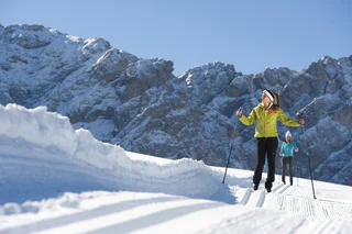
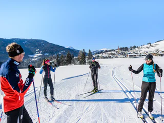
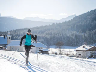
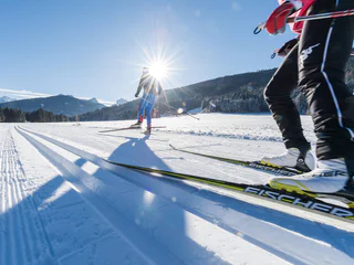
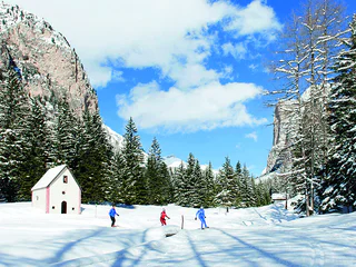
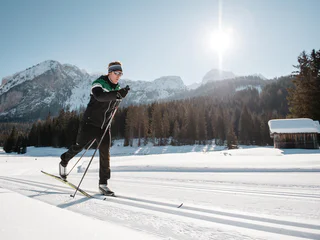
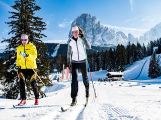
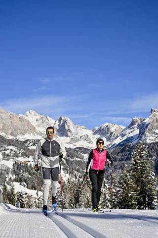
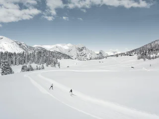
    In the Dolomites you can find a true cross-country skiing Eldorado: The Dolomiti Nordicski network includes a network of 1,300 kilometers of trails - this is the largest network of cross-country trails in Europe! With the cross-border ticket you can even go to East Tyrol on your cross-country skis. All you have to do is choose which of the varied, daily groomed trails you would like to use to explore the breathtaking landscape of the Dolomites UNESCO World Heritage Site: Should it be a panoramic circular route, a challenging high-altitude trail or do you prefer a leisurely route on the alpine pastures with hut enjoyment?

    Results
    Cross-country ski-track
    Ritsch cross-country trail
    Kastelruth/Castelrotto, Dolomites Region Seiser Alm

    This loop route starts and ends in Ritsch and passes through the Kleine Moos on practically flat terrain, making it perfect for newcomers to cross-country skiing. With exceptional views over the Dolomite peaks of the Langkofel and Plattkofel, the Ritsch Trail is an unforgettable experience. Those who are trying their hand at cross-country for the first time can get a real feel for the sport here before tackling the more challenging trails on the Seiser Alm.

    Difficulty: easy
    15 altitude up
    0h:00 min duration
    Cross-country ski-track
    Hartl cross-country trail
    Kastelruth/Castelrotto, Dolomites Region Seiser Alm

    Setting out from Ritsch, this varied loop-route leads north over the Große Moos and through vast Alpine meadows towards the cable car for Ortisei/St. Ulrich, with the nearby Dolomite peaks of the Langkofel and the Plattkofel ever in sight. After a short uphill stretch, we head downwards through a stretch of woodland and over Alpine meadows with traditional Alpine dairy farms. In Hartl, you come to a curve in the trail and ski on, slightly uphill, along the slope through the vast Alpine meadows. There is a steep uphill stretch just before the trail meets the Möser trail, followed by easy, undulating terrain back to the set-off point in Ritsch.

    Difficulty: medium
    150 altitude up
    0h:00 min duration
    Cross-country ski-track
    Wolfsbühl cross-country trail
    Kastelruth/Castelrotto, Dolomites Region Seiser Alm

    This easy loop-route leads out from the Cross-Country Centre in Ritsch and heads north over the vast Alpine meadows. With the Langkofel and the Plattkofel, this stretch of the trail boasts an incredible panorama. A short but hard ascent takes you to the Wolfbühl, the highest point of the route. Then continue onwards through a stretch of wood and over easy, undulating terrain back to the beginning of the trail.

    Difficulty: easy
    154 altitude up
    0h:00 min duration
    Cross-country ski-track
    Panorama cross-country trail
    Kastelruth/Castelrotto, Dolomites Region Seiser Alm

    The Panorama cross-country trail is classed as one of the most challenging loop-routes on the Seiser Alm and, with the Langkofel, Plattkofel and the Schlern, boasts a landscape which is second to none. The trail starts at the Cross-Country Centre in Ritsch and leads up to the mountain station of the Panorama chairlift with numerous sweeping curves through the Palude di Ladinser Moos. When you get to the Laurinhütte hut, loop round and head back to the start of the trail.  

    Difficulty: difficult
    308 altitude up
    0h:00 min duration
    Cross-country ski-track
    Joch cross-country trail
    Kastelruth/Castelrotto, Dolomites Region Seiser Alm

    The longest and most challenging cross-country trail of the Seiser Alm leads out from the Cross-Country Centre in Ritsch through vast Alpine meadows in a steep uphill to the mountain station of the Panorama chairlift. Then, in numerous curves, cross the Palude di Ladins/Ladinser Moos and continue on towards Joch and Spitzbühl, past the Laurinhütte hut and back to Ritsch. With the nearby Dolomite peaks of the Langkofel, Plattkofel and the Schlern massif, the views along this trail are breathtaking.

    Difficulty: difficult
    350 altitude up
    0h:00 min duration
    Cross-country ski-track
    Ritsch beginners run
    Kastelruth/Castelrotto, Dolomites Region Seiser Alm

    This easy loop trail is directly behind the Cross-Coutry Centre in Ritsch and leads from the Ritsch Hotel and Restaurant to the Große Moos. With outstanding views over the Langkofel and
    Plattkofel, this practice piste guarantees an unforgettable experience for young and old alike. Beginners can get a feel for cross-country skiing on the practice trails and hone their double poling, diagonal stride and herringbone techniques. The tracks are also ideal for warming-up before heading out on longer tours.

    Difficulty: easy
    30 altitude up
    0h:00 min duration
    Cross-country ski-track
    Link trail Sonne
    Kastelruth/Castelrotto, Dolomites Region Seiser Alm

    This link-trail connects the Hotel Sonne to the Möser, Wolfsbühl and Hartl trails. It ranges very little in elevation and is an easy run which is also suitable for beginners.

    Difficulty: easy
    39 altitude up
    0h:00 min duration
    Cross-country ski-track
    Connection Tesido to Val Casies Valley track
    Welsberg-Taisten/Monguelfo-Tesido

    Connection from Tesido to the Val Casies Valley track. From the crossing point there is the possibility to sci to Santa Maddalena or to Monguelfo and near the train station further to the 3 Zinnen Dolomites area.

    Difficulty: easy
    6 altitude up
    0h:00 min duration
    Cross-country ski-track
    18 SEXTEN - Circular Trail in the Fischleintal Valley
    Sexten/Sesto, Dolomites Region 3 Zinnen

    The 4.5 km long "Rundloipe Fischleintal" trail runs through the Fischleintal valley. This is easily accessible by public transport (Fischleinboden bus stop). There is also a pay parking possibility.                                                                            

    Difficulty: medium
    101 altitude up
    0h:00 min duration
    Cross-country ski-track
    Cross country track Weißenbach/Rio Bianco
    Ahrntal/Valle Aurina, Ahrntal/Valle Aurina

    Improving the health by the movement in the fresh mountain air and enjoying the beautiful nature. Having rest and relaxation on the trails leading through meadows and forests. And in the end, refreshment in one of the traditional huts completes a day of cross-country skiing.

    Difficulty: medium
    226 altitude up
    0h:00 min duration
    Cross-country ski-track
    Red cross-country ski run
    Sëlva/Selva, Dolomites Region Val Gardena

    During the wintertime the vallunga trasforms hisself in a Winterwonderland. The snow which covers the forest trasmits a mystic flair and you can enjoy the quitness of the valley.

    Difficulty: medium
    134 altitude up
    0h:00 min duration
    Cross-country ski-track
    Cross-Country ski run Pra da Rì
    Sëlva/Selva, Dolomites Region Val Gardena

    During the wintertime the vallunga trasforms hisself in a Winterwonderland. The snow which covers the forest trasmits a mystic flair and you can enjoy the quitness of the valley.

    Difficulty: difficult
    200 altitude up
    0h:00 min duration
    Cross-country ski-track
    Cross-country ski run green
    Sëlva/Selva, Dolomites Region Val Gardena

    During the wintertime the vallunga trasforms hisself in a Winterwonderland. The snow which covers the forest trasmits a mystic flair and you can enjoy the quitness of the valley.

    Difficulty: easy
    67 altitude up
    0h:00 min duration
    Cross-country ski-track
    Cross-country ski run blue
    Sëlva/Selva, Dolomites Region Val Gardena

    During the wintertime the vallunga trasforms hisself in a Winterwonderland. The snow which covers the forest trasmits a mystic flair and you can enjoy the quitness of the valley.

    Difficulty: easy
    20 altitude up
    0h:00 min duration
    Cross-country ski-track
    Link trail Saltria - Monte Pana
    Kastelruth/Castelrotto, Dolomites Region Seiser Alm

    The Saltria - Monte Pana link trail is reserved exclusively for experienced cross-country skiers. 

    It begins on a descent through vast Alpine meadows, leading shortly afterwards through the woods and along narrow riverside trail, in a constant slope to Monte Pana. The trail features numerous twists and turns and the utmost of caution is advised on one particularly exposed stretch.

    Difficulty: difficult
    147 altitude up
    0h:00 min duration
    Cross-country ski-track
    Link trail Ritsch-Saltria
    Kastelruth/Castelrotto, Dolomites Region Seiser Alm

    The trail links the Cross-Country Centre in Ritsch with Saltria. The Ritsch-Saltria link trail takes you straight downhill towards Saltria through wide Alpine meadows, and is classed as one of the most challenging cross-country trails on the Seiser Alm. In spring the trail may be partially iced over, so the utmost of caution is recommended.

    Difficulty: difficult
    0 altitude up
    0h:00 min duration
    Cross-country ski-track
    Störes
    Badia, Dolomites Region Alta Badia

    The slope is prearranged as agonistic and training area through the beautiful woods of San Cassiano.

    Difficulty: difficult
    83 altitude up
    0h:00 min duration
    Cross-country ski-track
    Sprint
    Badia, Dolomites Region Alta Badia

    The slope is prearranged as agonistic and training area through the beautiful woods of San Cassiano.

    Difficulty: difficult
    20 altitude up
    0h:00 min duration
    Cross-country ski-track
    Conturines
    Badia, Dolomites Region Alta Badia

    The slope is prearranged as agonistic and training area through the beautiful woods of San Cassiano.

    Difficulty: difficult
    81 altitude up
    0h:00 min duration
    Cross-country ski-track
    Gran Ancëi
    Badia, Dolomites Region Alta Badia

    The slope is prearranged as agonistic and training area through the beautiful woods of San Cassiano.

    Difficulty: medium
    42 altitude up
    0h:00 min duration
    Cross-country ski-track
    Saré
    Badia, Dolomites Region Alta Badia

    The slope is prearranged as agonistic and training area through the beautiful woods of San Cassiano.


    Difficulty: easy
    29 altitude up
    0h:00 min duration
    Cross-country ski-track
    Setsas
    Badia, Dolomites Region Alta Badia

    The slope is prearranged as agonistic and training area through the beautiful woods of San Cassiano.


    Difficulty: difficult
    79 altitude up
    0h:00 min duration
    Cross-country ski-track
    Scotoni
    Badia, Dolomites Region Alta Badia

    The slope is prearranged as agonistic and training area through the beautiful woods of San Cassiano.


    Difficulty: difficult
    65 altitude up
    0h:00 min duration
    Cross-country ski-track
    20 SEXTEN - Circuito Schönfelder
    Sexten/Sesto, Dolomites Region 3 Zinnen

    The "Circuito Schönfelder" has several entry points and is located in Moos. Ideally accessible by public transport (Rotwand bus stop) or, if applicable, parking facilities directly on site.            

    Difficulty: easy
    15 altitude up
    0h:00 min duration
    Cross-country ski-track
    23 SEXTEN - Sentiero sci-escursionistico
    Sexten/Sesto, Dolomites Region 3 Zinnen

    Slope Malga Klammach till Malga Nemes


    Start at the border between South Tyrol and the Italian Belluno. A beautifully ski / hiking trail with cross-country trails 

    Difficulty: medium
    380 altitude up
    0h:00 min duration
    Cross-country ski-track
    21 SEXTEN - night slope Waldheim - Moso
    Sexten/Sesto, Dolomites Region 3 Zinnen

    The circuit "Waldheim - Moos" is the perfect slope for all beginners.                                                                                                  

    Difficulty: easy
    20 altitude up
    0h:00 min duration
    Cross-country ski-track
    19 SEXTEN - Circuito Prato Larici
    Sexten/Sesto, Dolomites Region 3 Zinnen

    The "Circuito Prato larici" is a challenging trail with a length of approx. 3.5 km. The trail is located in the middle of our larch forests in the Val Fiscalina valley.                                                             

    Difficulty: difficult
    97 altitude up
    0h:00 min duration
    1 2 3 4
      image
      Summer
      Uphill Seespitz
      Meran and environs
      Starting point: Töll Etschbrücke (525 m) End point: Gasthaus …
      44 km total slope
      7 lifts
      Highest point: 2,505 m