Südtirol Guide App
South Tyrol´s digital travel guide
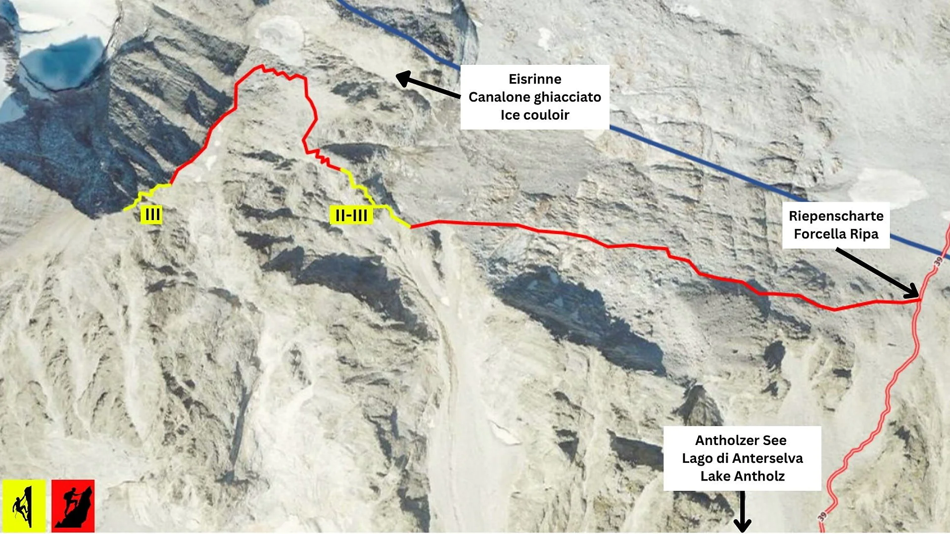
The 3,436 m high Hochgall is the highest peak of the Rieserferner Group and is considered one of the most beautiful mountains in the Eastern Alps. As a prominent main summit, it rises visibly above the Antholz Valley and is regarded as a high-alpine classic for experienced mountaineers. The ascent from Lake Antholz requires not only good fitness, but also alpine experience and confident climbing technique.
In spring, the summit can traditionally still be climbed via the distinctive ice gully. From summer onwards – around July – the snowmelt, however, makes this ascent no longer possible. In close cooperation with the Mountain Guides Association of the Central/Lower Puster Valley district, an alternative route was therefore identified and opened in 2025 through targeted improvements. This has made it possible to reach the Hochgall from the Antholz Valley throughout the entire summer season.
Starting point: Lake Antholz (1,642 m)
First, follow trail no. 39 to the Riepenscharte Pass. At the pass, a path branches off into rocky terrain. The route is marked with cairns. This is followed by a section of alpine climbing (difficulty II–III), secured with bolts and iron pegs (yellow section).
After that, the route continues over marked terrain (cairns) up to the ridge. On the eastern side, just below the ridge, it leads on to the next climbing section (yellow section). The second climbing part (grade III) is also secured with iron pegs and leads directly to the summit of the Hochgall (3,436 m).
Caution: The provided GPX data are for illustration purposes only and do not correspond exactly to reality. Significant deviations may occur – the tour description is definitive.
Descent
• Descent along the ascent route
• Alternative descent via the Rainer Ridge (requires a 40 m rope)
Skills required
• Surefootedness and alpine experience
• Climbing proficiency up to grade III
• Excellent physical condition
Equipment
• 30 m rope, or 40 m rope if descending via the Rainer Ridge
• Alpine safety equipment required
• Crampons and ice axe may be required depending on conditions

Thank you for signing up!
You are already subscribed
Confirm your registration
To complete your subscription, open the email we just sent you and click on the confirmation link.
Can’t find it? Check your spam folder too.
We noticed that you are already subscribed to our Newsletter. We will update you on exclusive offers, fun adventures and more so you can make the best out of your vacation.
We noticed that you already tried to subscribe to our Newsletter in the past but didn’t confirmed the subscription. We have resent you an email now, please check your inbox and spam folder to confirm.