Skip to content
added to favourites
removed from favourites
Oops! Something went wrong. Try again
Your account is being created
Your account has been successfully created and you are now logged in
You are logged out.

How best do I reach the Sellajoch pass?

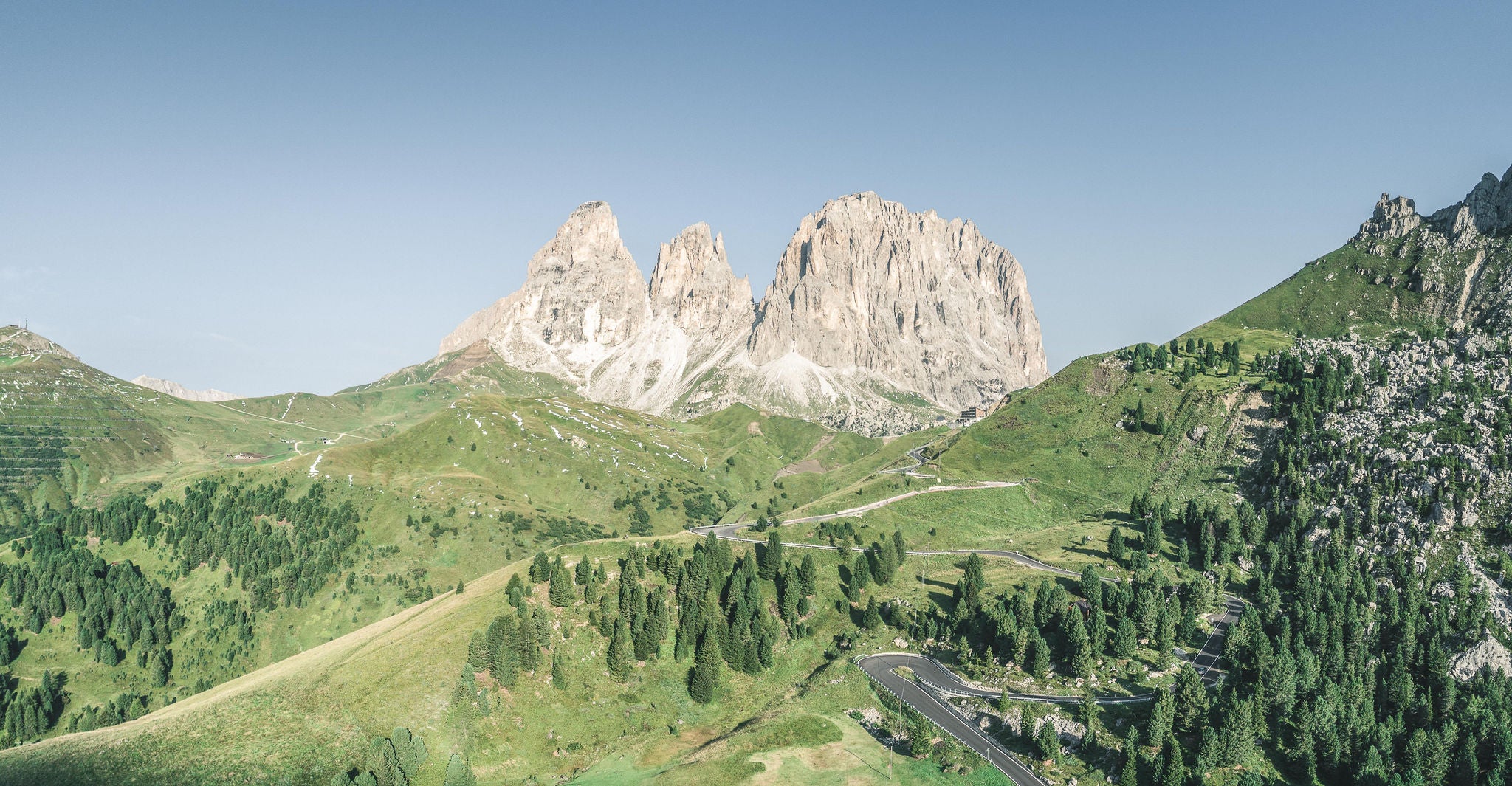
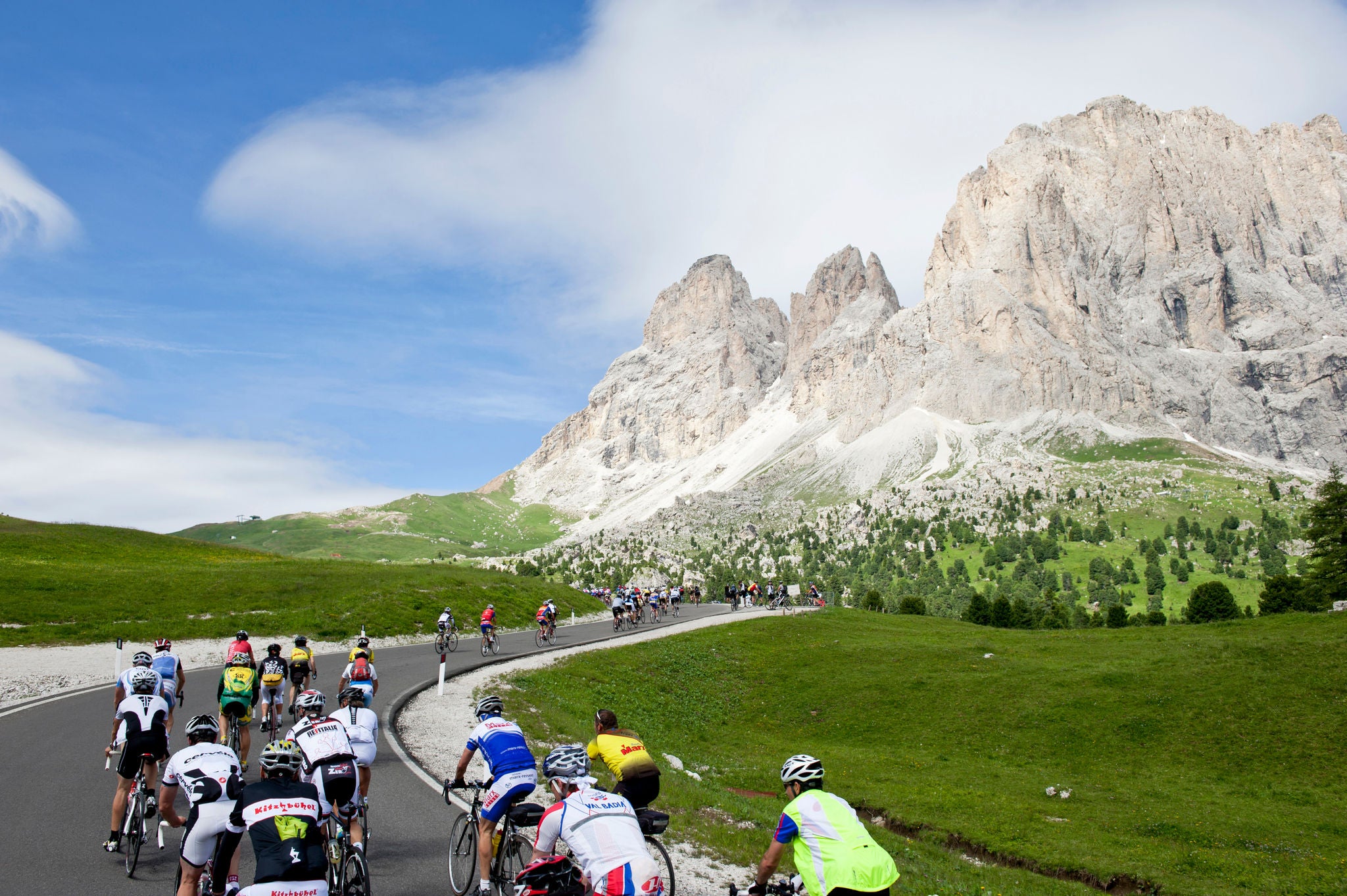
The Sellajoch Pass ( 2,218 m a.s.l. - Italian: Passo Sella, Ladin: Jëuf de Sela)) is located between the famous Langkofel mountain and the impressive Sella massif. The pass connects the Ladin Val Gardena valley with the Val di Fassa valley in Trentino and is a popular destination for experiencing the unique landscape of the UNESCO World Heritage site Dolomites. The  best way is without a car: that’s because on foot, by bike, via the cable car or public transport, you can conquer the passes in a sustainable manner whilst enjoying the  superlative backdrop  of the Dolomites

Reaching the Sellajoch pass on foot

One foot after the other is the best way to reach the pass. In addition to sporting activities in the breathtaking landscape of the Dolomites, hikers can also experience the  flora and fauna  of this fascinating mountain world up close and personal.

Tip: Before setting off, inform yourself about safety in the mountains, the current weather conditions and whether the hiking trail of your choice is open.

From Plan de Gralba (Sëlva/Selva):
duration: 1:20 h, altitude difference: 400 m ↑, length: 5.2 km
Follow hiking trail no. 657 to the Sellajoch pass.

From Sëlva/Selva:
duration: 2:30 h, altitude difference: 614 m ↑, length: 8 km
Follow hiking trails no. 27, no. 21 A and then no. 526 to the Sellajoch pass. 

From S.Crestina/S.Cristina:
duration: 3:30 to 4 h, altitude difference: 800 m↑, length: 8.3 km
Follow hiking trails no. 30, no. 528 and finally trail marker no. 526 to the Sellajoch pass. 

From Urtijëi/Ortisei:
duration: 6:30 h, altitude difference: 1,013 m ↑, length: 13 km
First take the hiking trail along the railway platform promenade to S.Crestina/S.Cristina. From there, the hiking trail leads via trail markers no. 30 B, no. 23, no. 528 and finally no. 526 to the Sellajoch pass.

From Canazei (Val di Fassa valley):
 duration: 2:30 h,  altitude difference: 763 m ↑, length: 6.3 km
From the St. Florian church in the village centre, hike up the Strèda dò Ruf de Antermont road and, after a short time, arrive at a wooden bridge. From the bridge, follow trail no. 655 towards Pian de Frataces-Lupo Bianco (about 1 hour) and then hike through the Salei valley to the Sellajoch pass.

From Plan de Gralba (Sëlva/Selva):
Variant A): duration: 1 h, altitude difference: 260 m ↑, 90 m↓,  length: 3.1 km
To the mountain station of the Piz Seteur gondola cable car and then follow hiking trail no. 657 to the Sellajoch pass.
Variant B): duration: 25 minutes, altitude difference: 75 m ↑, length: 1.3 km
Take the Piz Seteur gondola cable car and the Gran Paradiso chairlift and then follow trail marker no. 526 (Steinerne Stadt (Stone City)).

From Selva:
duration: 1:30 h, altitude difference: 141 m ↑, length: 4.3 km
Take the Ciampinoi gondola cable car and then follow hiking trails no. 21 A and no. 526 to the Sellajoch pass.

From S.Crestina/S.Cristina:
duration: 1:30 h , Altitude difference: 263 m ↑, 128 m ↓, length: 4.7 km 
Variant A): First take the Monte Pana chairlift, then the Mont de Sëura chairlift then follow hiking trails no. 526 B, no. 528 and no. 526 to the Sellajoch pass.
Variant B): Take the Monte Pana and Mont de Sëura chairlifts, follow hiking trail no. 526 B, then take the Tramans chairlift. Finally, trail markers no. 21 A and no. 526 lead to the Sellajoch pass.

From the Val di Fassa valley:
duration: 40 minutes, altitude difference 216 m ↓, length: 2.1 km
With the Col Rodella cable car (Campitello) or the Pradel - Rodella cable car (Pian de Frataces), then walk along hiking trailno. 557 to the Sellajoch pass.

Tickets for the cable cars & lifts can be purchased directly on site. In addition to one-way tickets, the following advantage cards are available:

  • Gardena Card: using this card, enjoy unlimited access to all 17 cable cars & lifts in Val Gardena for three or six consecutive days (from the first day). (price for bike transport not included).
  • The Supersummer Card:120 cable cars & lifts in the Dolomites can be used with the Supersummer Card (day pass/3 out of 4 days/5 out of 7 days), including bike transport. The ticket is valid for all cable cars & lifts on the aforementioned Sellaronda tours.
  • The Val di Fassa PanoramaPass: With the PanoramaPass, ride all 33 cable cars without restrictions for 3 days within 6 days, for 6 days within 6 days or  for 7 days within 13 days (from date of purchase). Some permit bike transport (ticket for bike transport not included).

Note: You may not use the lifts with the Val Gardena Mobil Card or the Val di Fassa Guest Card. Dogs can be transported only when muzzled.

The most scenic hikes to Sellajoch pass

In addition to challenging routes, leisurely and partially wheelchair accessible trails lead to the Sellajoch pass - magnificent panoramic views of the Sella massif, Langkofel mountain and the surrounding Dolomite massifs are guaranteed!

From Monte Pana via Mont Sëura to Passo Sella

From Monte Pana via Mont Sëura to Passo Sella

Reaching the Sellajoch pass by bike

Easily reach the Sellajoch pass viaracing bike,mountain bikeor e-bike.  We recommend finding out in advance if the route of your choice is open in addition to the current weather. Also, please obey fair and safe cycling practices. According to the local road code, the pass is passable via bike using the provincial road (SS242) without restrictions.

From Sëlva/Selva:
Length: 16,9 km, difference in elevation: 796 hm ↑, 796 hm ↓, duration: 2:35 hours, difficulty level: medium
MTB
 Passo Sella circuit: Starting point is the cycle path Plan. Follow mountain bike track no. 308 to the Passo Sella.

From the Val de Fascia/Val di Fassa:
Sellaronda mountain-biking route clockwise:
Length: 59.7 km, altitude difference: 440 m ↑, 4130 m ↓, duration: 6-7 hours, degree of difficulty: medium
Start: Campitello at the Col Rodella cable car. Take the Col Rodella cable car to the mountain station, then follow the orange Sellaronda mountain biking markers.

Sellaronda mountain-biking tour counterclockwise:
Length: 56.7 km, altitude difference: 1020 m ↑, 3660 m ↓, duration: 6-7 hours, degree of difficulty: hard
Start: parking lot of the Belvedere cable car. Take the Belvedere and Col dei Rossi cable cars to the mountain station, then follow the green Sellaronda mountain biking markers.

From Arabba:
Sellaronda mountain biking route clockwise
:
Length: 59.7 km, altitude difference: 440 m ↑, 4130 m ↓, duration: 6-7 hours, degree of difficulty: medium
Start: Funifor Arabba-Porta Vescovo cable car. Take the lift to the mountain station, then follow the orange Sellaronda mountain biking signs.

Sellaronda mountain-biking route counterclockwise:
Length: 56.7 km, altitude difference: 1020 m ↑, 3660 m ↓, duration: 6-7 hours, degree of difficulty: hard
Start: Arabba-Monte Burz chairlift. Take the lift to the mountain station, then follow the green Sellaronda mountain biking signs.

Tickets for the cable cars can be purchased directly on site or online. 5€/bike will be charged if not already included with the cable-car ticket. The following advantage card is also available for cyclists:

  • The Supersummer Card: take advantage of 120 cable cars in the Dolomites (day ticket/3 to 4 days/5 to 7 days/season ticket). Bike transport is included. The ticket is valid, for example, for all the cable cars of the Sellaronda tours described above.
  • The Arabba Marmolada Summer Pass: With the pass in hand, use the 6 cable cars in Arabba on 3 out of 4 days or on 5 out of 7 days. Bike transport is included.

Note: You may not use the cable cars with the Val di Fassa Guest Card or Trentino Guest Card. 

The most scenic hikes to Sellajoch pass

Are you keen to pedal on the mountain pass road, or would you prefer a flowing mountain-bike trail? There are plenty of tours on two wheels up to and around the Sellajoch pass.

Well equipped & fully charged

To make sure that nothing gets in the way of your cycling experience around the Grödnerjoch pass, there are numerous bike rental shops and e-bike charging stations nearby.

Unfortunately we could not find any result

Arriving to the Sellajoch pass by bus

Using the Mobilcard or the regional Guest Cards  (e.g. Val Gardena Mobil Card), guests can travel by bus free of charge (validation required at the beginning of each journey). Alternatively, tickets can be purchased directly on the bus. Children younger than 6 do not need a ticket.
With the Val di Fassa Guest Card and the Trentino Guest Card, use all public transport within the province of Trento, as well as the bus line no. 180 to Bolzano/Bozen and the bus line no. 471 to the Sella massif and the Pordoijoch pass without restrictions.
Dogs must be kept on a leash and muzzled if necessary. Small dogs travel free of charge.

From Val Gardena:
Take bus line no. 471 from the Val Gardena valley - Sellajoch pass - Canazei/Pordoi. 
From Val Gardena, reach the Sellajoch pass every 15 minutes during peak hours, direct journeys depart early in the morning, then typically afterwards with a change in Plan de Gralba with the bus lines no. 350 and no. 352 to bus line no. 471.

Note: bus line no. 471 runs from Plan de Gralba every quarter of an hour. If the bus is already full, please wait for the next bus or alternatively use the cable car from Plan de Gralba .

From the Val Badia valley:
From Corvara, reach the Sellajoch pass either with bus line no. 473 Corvara - Grödnerjoch pass - Val Gardena valley (every hour) or with the bus line no. 471 (from Plan de Gralba every quarter of an hour) - change at the Miramenti junction - Service every hour. 

From the Val di Fassa valley:
From Canazei in the Val di Fassa valley, there is an hourly direct connection with bus line no. 471.

Reaching the Sellajoch pass by private vehicle

Although it is permitted to drive to the  Sellajoch pass  in summer by private vehicle, we advise against it due to road congestion and for reasons of sustainability. Parking at the pass  is limited. Parking on the side of the road is sanctioned by law enforcement officers according to the road code.
PLEASE NOTE: Traffic jams and other inconveniences can be expected at any time during the summer months. For the current traffic situation or possible pass closures, we recommend consulting the traffic information centre.  

In South Tyrol, sustainable transportation is a top priority. For this reason, it is recommended that visitors use sustainable forms of transport whenever possible and use public transport to get to the desired starting points for hikes or other activities.

Question:  Are there public toilets at the Sellajoch pass?
Answer: There are no public toilets on the Sellajoch pass, but there are several places to stop at the top of the pass and along the hiking and biking trails (huts, bars and restaurants) where toilets can be used by those who make a purchase.  

Question:  When is the best time to visit the Sellajoch pass?
Answer: Due to the large crowds especially during the summer months (July and August), we recommend visiting the Sellajoch pass outside of core hours (9:00 am - 12:00 pm).

Question:  Where can I get more information about the Sellajoch pass and the surrounding area?
Answer:  In the relevant Val Gardena or Val de Fascia/Val di Fassa Tourist Infos:
-Tourist Info Val Gardena: Tel. +39 0471 777 777, info@valgardena.it, www.valgardena.it
-Tourist Info Val de Fascia/Val di Fassa: Tel. +39 0462 609500, info@fassa.com, www.fassa.com

Located close by

Accommodation image
Finish your booking for
Accommodation name
0  room rooms Not selected No board Breakfast Half board Full board All inclusive
Total price: 0 €
(incl. VAT / excl. local tourism tax)